All Activity
- Past hour
-

First Legit Storm Potential of the Season Upon Us
40/70 Benchmark replied to 40/70 Benchmark's topic in New England
I think I've seen enough of this event. Just wrapping up my map and narrative. -

First Legit Storm Potential of the Season Upon Us
Baroclinic Zone replied to 40/70 Benchmark's topic in New England
Nice hit here -

First Legit Storm Potential of the Season Upon Us
MJO812 replied to 40/70 Benchmark's topic in New England
Nice for sne.thumb.png.7c3f4047643eb09bbe71a8d52b239bd6.png)
-
Oh really?
-

First Legit Storm Potential of the Season Upon Us
dendrite replied to 40/70 Benchmark's topic in New England
It’s curling the southern end of the vortmin pretty good as it approaches SNE. We’ll have to see if that suite trends that way. -

First Legit Storm Potential of the Season Upon Us
Sey-Mour Snow replied to 40/70 Benchmark's topic in New England
Goes from 1-2 flurries to 2-4 flurries -
First Legit Storm Potential of the Season Upon Us
MJO812 replied to 40/70 Benchmark's topic in New England
.thumb.png.99d542e9038a64f100a057543662ab56.png)
-
I mean it matches the Euro AI, rgem and AI gfs.
-
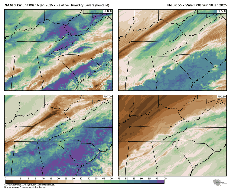
Great trend for the mtns and foothills with the moisture transport on NAM 3km. Still need a bit more but as we know in these situations the far western extent of the precip shield is sometimes underestimated from the moisture being pushed up and over the arctic front. Unbelievably, I think we’re still in the game with a small chance.
-
Very nice 2-4 inches
.thumb.png.eb1a16a1da8986c8214a6cef44f68a1d.png)
-

Storm potential January 17th-18th
Franklin0529 replied to WeatherGeek2025's topic in New York City Metro
It's always amped an usually wrong -

Southern MD / Lower Eastern Shore weather discussion
AlexD1990 replied to PrinceFrederickWx's topic in Mid Atlantic
My bad, but who knows, could still bump west. And it looks like there will be some more chances in the next 2 weeks Sent from my Pixel 9 Pro XL using Tapatalk -
First Legit Storm Potential of the Season Upon Us
40/70 Benchmark replied to 40/70 Benchmark's topic in New England
-

Storm potential January 17th-18th
EastonSN+ replied to WeatherGeek2025's topic in New York City Metro
Weird solution -
First Legit Storm Potential of the Season Upon Us
dendrite replied to 40/70 Benchmark's topic in New England
NAM was the flattest at H5…looks more in line now to me -
-
First Legit Storm Potential of the Season Upon Us
40/70 Benchmark replied to 40/70 Benchmark's topic in New England
2 minutes later "Little west, but not quite enough for most" -
Another Coating of Snow Saturday - "It's all we Got"
Sey-Mour Snow replied to Sey-Mour Snow's topic in New England
100% -
First Legit Storm Potential of the Season Upon Us
Baroclinic Zone replied to 40/70 Benchmark's topic in New England
Yeah, nice curl to that vorticity. Heights also higher over us. should bode well -
-
3k not as far west, but west of 18z.
-
First Legit Storm Potential of the Season Upon Us
40/70 Benchmark replied to 40/70 Benchmark's topic in New England
This period can't even do boring right....the boring is mundanely unremarkable and not extreme. @Typhoon TipI'll bet we would be challenging seasonal futility records for snowfall region wide if CC were real....literature be damned. The scholarly peers should review that. -
Keep us posted on tonight. Can actually see heavy stuff moving over your place on radar for once. I smell an overperforming weekend again
-

First Legit Storm Potential of the Season Upon Us
ORH_wxman replied to 40/70 Benchmark's topic in New England
NAM significantly west -
I think we need to separate the threads for tomorrow’s little event and Sunday, but I’ll defer to Randy and the mods. I guess tomorrow doesn’t affect enough of the sub?
.png.a435d2b2749bbdba0698546e30431386.png)

.png.539f4f2d1068fcfaf8e69522f1086d17.png)


.png.f58a066d2a197866f867afe2de151848.png)


