All Activity
- Past hour
-
Holy Jesus it's oppressive out today. I stepped outside to grab my kid's swim gear after a late night at the park and it felt like I was smashed by an industrial-sized wet towel. Still better than 55 and rain.
-
Showers developed early this morning, and getting a nice soaker atm. Flower garden planted yesterday, so this rain is right on time.
-

2025-2026 ENSO
40/70 Benchmark replied to 40/70 Benchmark's topic in Weather Forecasting and Discussion
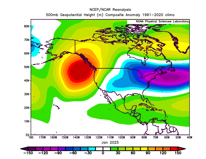
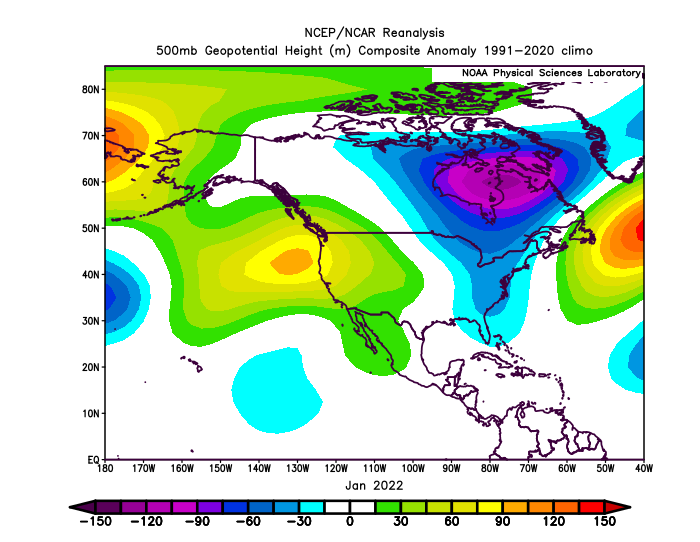
Believe it or not, sometimes the big storm doesn't work out and the reason why isn't directly attributable to climate change. Even in those to monthly composites, its easy to see that the January 2022 pattern was much more suportive relative to January 2025, when the lowest heights were right over the NE. The vortex was a little further NW, over SE Canada in 2022, which was less supressive. -
I'll be driving through your neighborhood later today on our way to Presque Isle for a couple of days and then P.E.I. for a week.
-
2025-2026 ENSO
40/70 Benchmark replied to 40/70 Benchmark's topic in Weather Forecasting and Discussion
First of all, that is a monthly mean composite, but the ridge was actually a bit more favorably positioned at the during the timeframe that the blizzard took place. Secondly, the better positioning of the ridge in conjunction with the strongly negative WPO that was in place that month (and season) made that pattern more conducive than this past January. -
Not once did Scoots say anything about a cool, chilly pattern. Who the hell is thinking "Looks like big heat is gone for a while" means 30s at night? The mental gymnastics, projections, hyperbole and assumptions in here could keep a psychiatrist going for years. If we as a science forum have gotten to the point where we can't call it like the models show, we've jumped the shark.
-

Central PA Summer 2025
Mount Joy Snowman replied to Voyager's topic in Upstate New York/Pennsylvania
Did you see this week's update where they basically removed everything?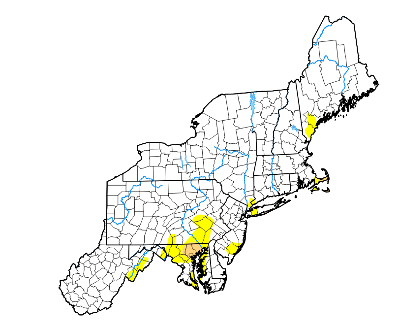
-
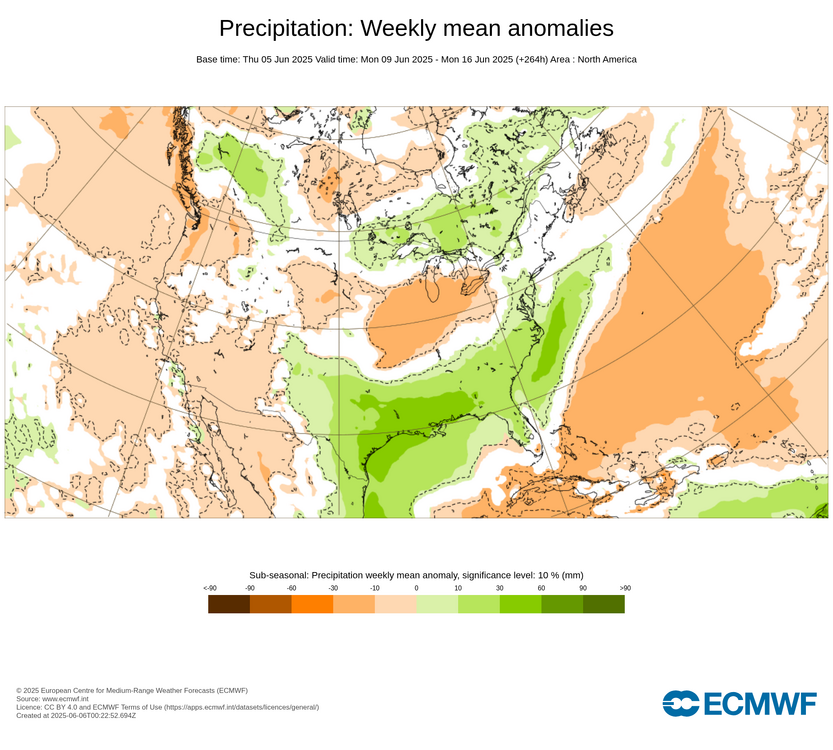
We’ll see if the pattern can dry out a bit after the 16th and maybe promote higher temperatures than we got the last few days.
-
The +PNA ridge worked out for us in January 2022 in that position just off the West Coast in conjunction with the solid MJO 8.
-
It'll come sneaking in...
-
The thing is though it’s misleading because it’s not cool , chilly pattern. It’s still AN . The ACATT crew is thinking lots of 60’s/70’s with 30’s/ 40’s at night . Nothing wrong with low-upper 80’s in Junorch
-
Nope, I hear you, Just like the 13th rainy Saturday in a row coming up, Nothing we can do about it.
-
72 mph near Tip https://x.com/wx1box/status/1930977229669912888?s=46&t=dhcbvkjmRcyBVQtDxJ3lRg
-
I actually would like it warmer, but calling it as I see it. Can't let emotions get in the way unlike some.
-
Good luck here. We used to live more in model reality but that’s moved on to filling agendas with strong hyperbole. The ones to trust are the ones who can actually say when models show the weather they don’t want. Like Coastalwx loves heat and humidity in the summer… if he says models have backed off a bit on heat, they did.
-
Have to watch next Friday/Saturday for some severe potential...been a signal for a few days. I think we get one hot day end of next week ahead of the front but have to watch warm front.
-
You will get attacked from the heat humpers for this.
-
Yeah couple warm days maybe next weekend and then EPS seems to be backing off warmth here.
-
2025-2026 ENSO
40/70 Benchmark replied to 40/70 Benchmark's topic in Weather Forecasting and Discussion
Yea, that was an instance of the PNA ridge beging just off of the west coast. I'm sure that the active jet didn't help matters, but the positioning of the PNA ridges was consistently an issue. -
It may never hot again. wow
-
That's ridiculous lol what are the chances
-
Thinking of going to Ringe, NH as a spot...there is a place with some decent views there. But I am thinking the area from Rindge/Fitchburg/Leominster may be the "best" local corridor today. Right along the instability axis and somewhat stronger (still meh) wind shear. What is our goal for today? See some CGs and hopefully a shelf cloud.
-
The EPO was only consistently negative in January. As the big swings in December and February lead to more neutral those months. Unfortunately, the big snowstorm in January got suppressed down to the Gulf Coast.
-
Rte 2 was fun coming down the hill by KFIT. Serious ponding and I've been driving my daughter's smaller car for a couple of days. Was like I was in a wave pool. Some good lightning. Rain wasn't so bad when I was driving, but earlier it was nasty
-
I'm taking soem classes in coding and we design. One of the things I want to get better at is retrieving data from the web and using it in web pages I create. For example I'd like to create a calendar with graphics showing the frequency of rainy weekends here in Southern Vermont this year. Can you point me to APIs and documentation to use the NOAA/NWS data? Perhaps just starting with precipitation, max/min temps, and that sort of data for a given location.