All Activity
- Past hour
-

Major Hurricane Melissa - 892mb - 185mph Jamaica landfall
Floydbuster replied to GaWx's topic in Tropical Headquarters
Dropped a category, I see. I figured they'd at least hold at a 4 since the satellite appearance had recovered this evening. But a few knots difference is paltry. I read that maybe recon is not finding much to support above 115 mph. -
Major Hurricane Melissa - 892mb - 185mph Jamaica landfall
Windspeed replied to GaWx's topic in Tropical Headquarters
Hopefully, they will stay out of the southeastern quadrant of the eyewall. Based on radar motion, they should miss it to their west. The terrain at the coast is rather rugged west of Santiago, so surge isn't as much a problem there. But Santiago proper has the harbor and low-lying area. They probably will get some surge, but not as bad as actually taking a hit from within eyewall. Melissa is also moving at a pretty decent clip now, so hopefully inland flooding off of the higher elevations won't compound the issue. -

Major Hurricane Melissa - 892mb - 185mph Jamaica landfall
Windspeed replied to GaWx's topic in Tropical Headquarters
Dropped a category, I see. I figured they'd at least hold at a 4 since the satellite appearance had recovered this evening. But a few knots difference is paltry. -
Major Hurricane Melissa - 892mb - 185mph Jamaica landfall
gallopinggertie replied to GaWx's topic in Tropical Headquarters
Any thoughts on surge threat for Santiago de Cuba? I looked the city up on Google street view, there are some photo spheres showing that part of the colonial heart is just a few feet above the bay there. - Today
-

Major Hurricane Melissa - 892mb - 185mph Jamaica landfall
WxWatcher007 replied to GaWx's topic in Tropical Headquarters
2:00 AM EDT Wed Oct 29 Location: 19.7°N 76.4°W Moving: NE at 10 mph Min pressure: 952 mb Max sustained: 125 mph -

Major Hurricane Melissa - 892mb - 185mph Jamaica landfall
Windspeed replied to GaWx's topic in Tropical Headquarters
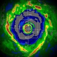
Trying to adjust and pinpoint motion to landfall. Barring any wobbles, it looks like the center will cross somewhere directly between Chivrico and Santiago. There is a small community on route 20 located there with an icon on the coast named Playa Aserradero. Not sure if anyone is familiar with the coastal region there. -

Major Hurricane Melissa - 892mb - 185mph Jamaica landfall
WxWatcher007 replied to GaWx's topic in Tropical Headquarters
With recon done I doubt there are any new updates to intensity outside of whatever they decide at 2am. -

Major Hurricane Melissa - 892mb - 185mph Jamaica landfall
Windspeed replied to GaWx's topic in Tropical Headquarters
Perhaps two to three hours to landfall based on radar. -

Major Hurricane Melissa - 892mb - 185mph Jamaica landfall
WxWatcher007 replied to GaWx's topic in Tropical Headquarters
Not sure how much time it has left, but it’s really trying to intensify. -

Major Hurricane Melissa - 892mb - 185mph Jamaica landfall
Windspeed replied to GaWx's topic in Tropical Headquarters
VHT bursting in the northern eyewall. -
That's really interesting! I tapped it...... Hope you guys get good soaking rains.
-

Major Hurricane Melissa - 892mb - 185mph Jamaica landfall
Windspeed replied to GaWx's topic in Tropical Headquarters
Chivrico is a town that might get a direct hit. It's west of Santiago on coastal route 20. It's located at -76.4 W and that looks about where the eye will come ashore. Santiago should be just far enough east to stay out of the eyewall. Fortunately, the location around Chivrico is not as prone to surge. Melissa will be mostly a wind event and hopefully it's gaining enough forward speed to mitigate flash flooding from torrential rain. -

Major Hurricane Melissa - 892mb - 185mph Jamaica landfall
Nibor replied to GaWx's topic in Tropical Headquarters
Worried about Santiago de Cuba. Second largest city in the country. -
Picked up another 1.3 inches of rain since that last post. It was drizzle and light rain most of today.
-

Major Hurricane Melissa - 892mb - 185mph Jamaica landfall
Windspeed replied to GaWx's topic in Tropical Headquarters
Impressive. -

Major Hurricane Melissa - 892mb - 185mph Jamaica landfall
Boston Bulldog replied to GaWx's topic in Tropical Headquarters
Agreed, the ongoing contraction of the core as the vortices get back in concert with each other tells me we should see additional pressure falls through landfall. Insanely anomalous to get a Cat-4 strike in this area of Cuba that is so well guarded by mountainous islands. Sandy is obviously the gold standard when it comes to poleward tracking hurricane intensification over the Eastern Cayman Trench (kind of shocked there isn't a more descriptive name that's easy to find for this body of water), but Melissa is putting on an impressive performance. -
I hate the cold, dark mornings so yes it's fine. Can't imagine it still being dark at 8-830.
-

Major Hurricane Melissa - 892mb - 185mph Jamaica landfall
Windspeed replied to GaWx's topic in Tropical Headquarters
Really impressed by how well Melissa's mid level vortex held together and how fast the eyewall is reorganizing. It's not got a lot of time before landfall in Cuba, but it has incredible upper level support and obviously high SSTs to reintensify some in short order. At least maintain current intensity. Should be a Category 4 strike. -

Major Hurricane Melissa - 892mb - 185mph Jamaica landfall
WxWatcher007 replied to GaWx's topic in Tropical Headquarters
Given how light the wind was, even if it missed by a touch I would bet it doesn’t make much of a difference. -

Major Hurricane Melissa - 892mb - 185mph Jamaica landfall
Wannabehippie replied to GaWx's topic in Tropical Headquarters
I am not sure the plane got dead center of the hurricane. https://www.tropicaltidbits.com/recon/recon_AF301-2613A-MELISSA.png https://www.tropicaltidbits.com/recon/recon_AF301-2613A-MELISSA_dropsondes.png -

Major Hurricane Melissa - 892mb - 185mph Jamaica landfall
WxWatcher007 replied to GaWx's topic in Tropical Headquarters
Center sonde has a 954mb reading with 6kt wind so despite the satellite appearance, it hasn’t translated into strength in a substantial way yet. Obviously still need to see the SW and NE quadrants. -

Major Hurricane Melissa - 892mb - 185mph Jamaica landfall
Boston Bulldog replied to GaWx's topic in Tropical Headquarters
Given the broader core and limited time over water, I would bet against Melissa re-attaining Cat 5 status. Perhaps flight level winds will begin to resemble that intensity again, but it is highly unlikely those winds would get down to the surface in time. If Melissa had another 18 hours or so before landfall it’s a different story. -

Major Hurricane Melissa - 892mb - 185mph Jamaica landfall
Wannabehippie replied to GaWx's topic in Tropical Headquarters
11:00 PM EDT Tue Oct 28 Location: 19.3°N 76.6°W Moving: NE at 9 mph Min pressure: 950 mb Max sustained: 130 mph


