All Activity
- Past hour
-

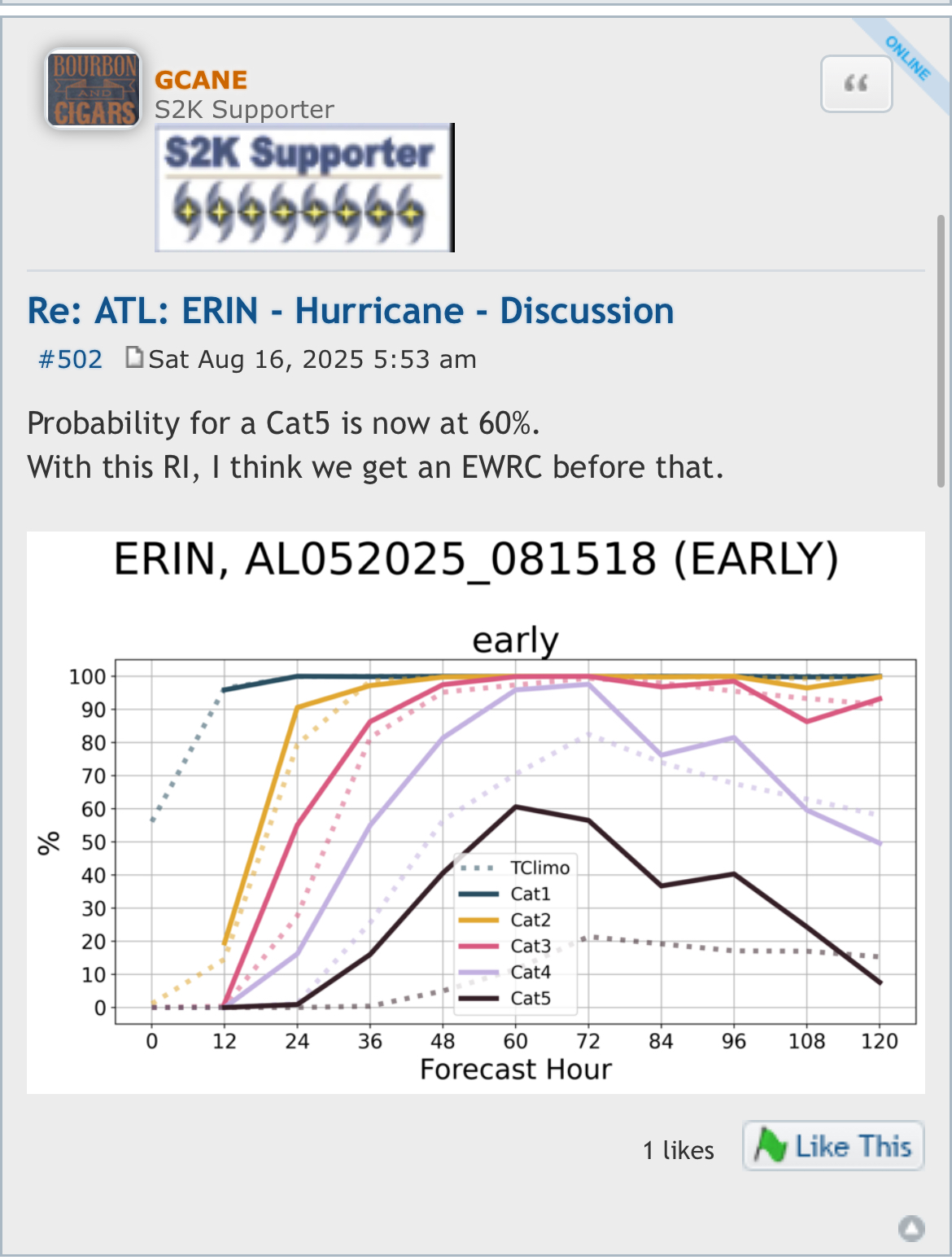
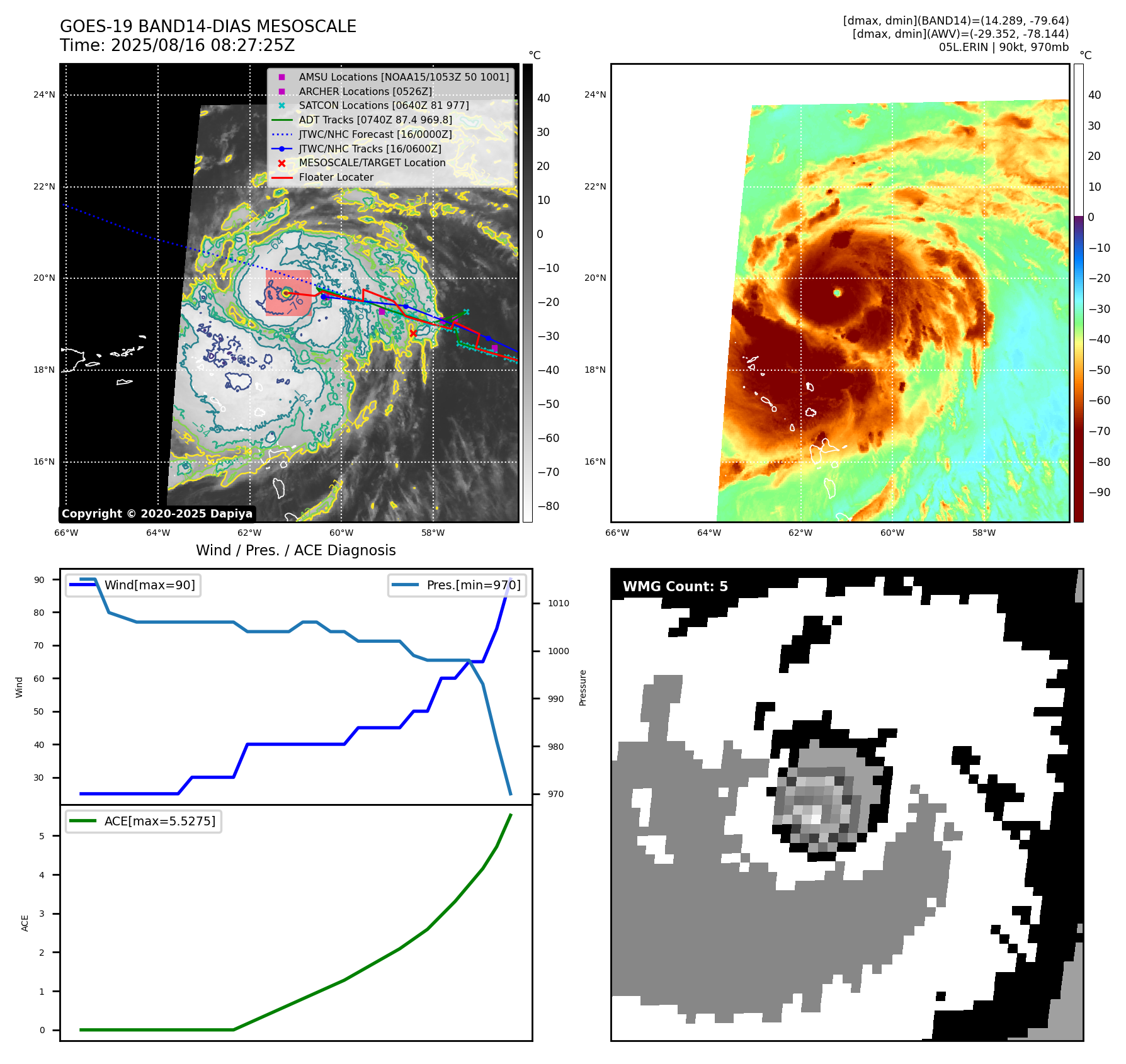
Hurricane Erin - NOW 130 MPH AND 948 MB
Wannabehippie replied to BarryStantonGBP's topic in Tropical Headquarters
5:50 AM AST Sat Aug 16 Location: 19.6°N 61.5°W Moving: WNW at 20 mph Min pressure: 948 mb Max sustained: 130 mph -
Erin's a regular smoke show this morning. Impressive intensification overnight.
-

Hurricane Erin - NOW 130 MPH AND 948 MB
olafminesaw replied to BarryStantonGBP's topic in Tropical Headquarters
Not uncommon for strong hurricanes to continue trucking along more to the South than expected. Once it feels the weakness in the ridge, it will sharply turn right, probably not much West of forecast -

Hurricane Erin - NOW 130 MPH AND 948 MB
BarryStantonGBP replied to BarryStantonGBP's topic in Tropical Headquarters
-
Hurricane Erin - NOW 130 MPH AND 948 MB
BarryStantonGBP replied to BarryStantonGBP's topic in Tropical Headquarters
OI LASS WE COULD DO WITH SOME MORE INNIT
-
Hurricane Erin - NOW 130 MPH AND 948 MB
BarryStantonGBP replied to BarryStantonGBP's topic in Tropical Headquarters
How do you rate Erin right now lad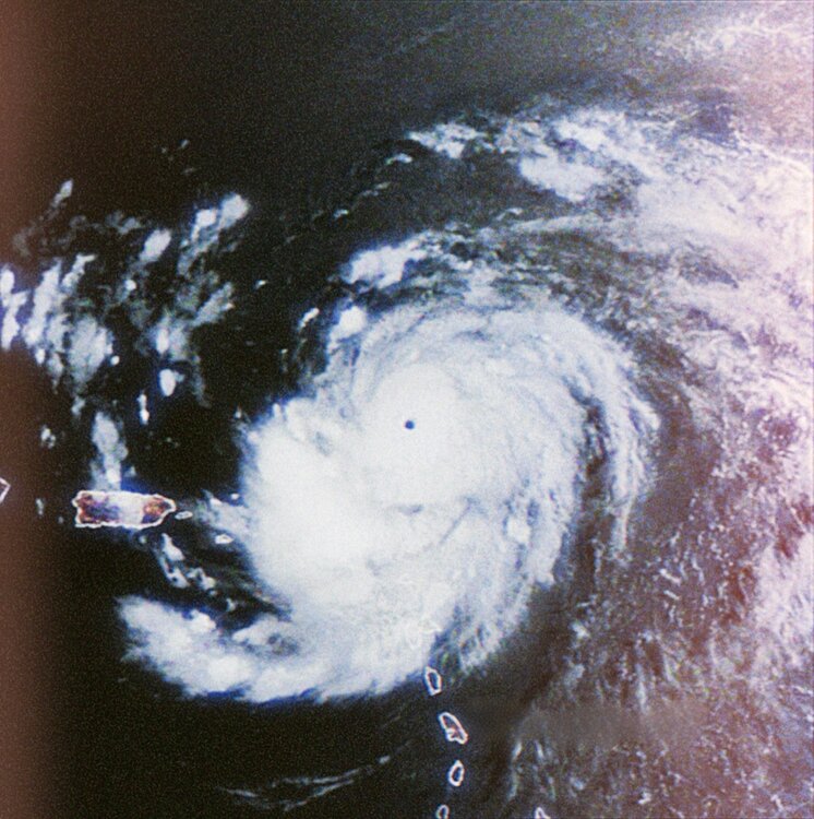
-
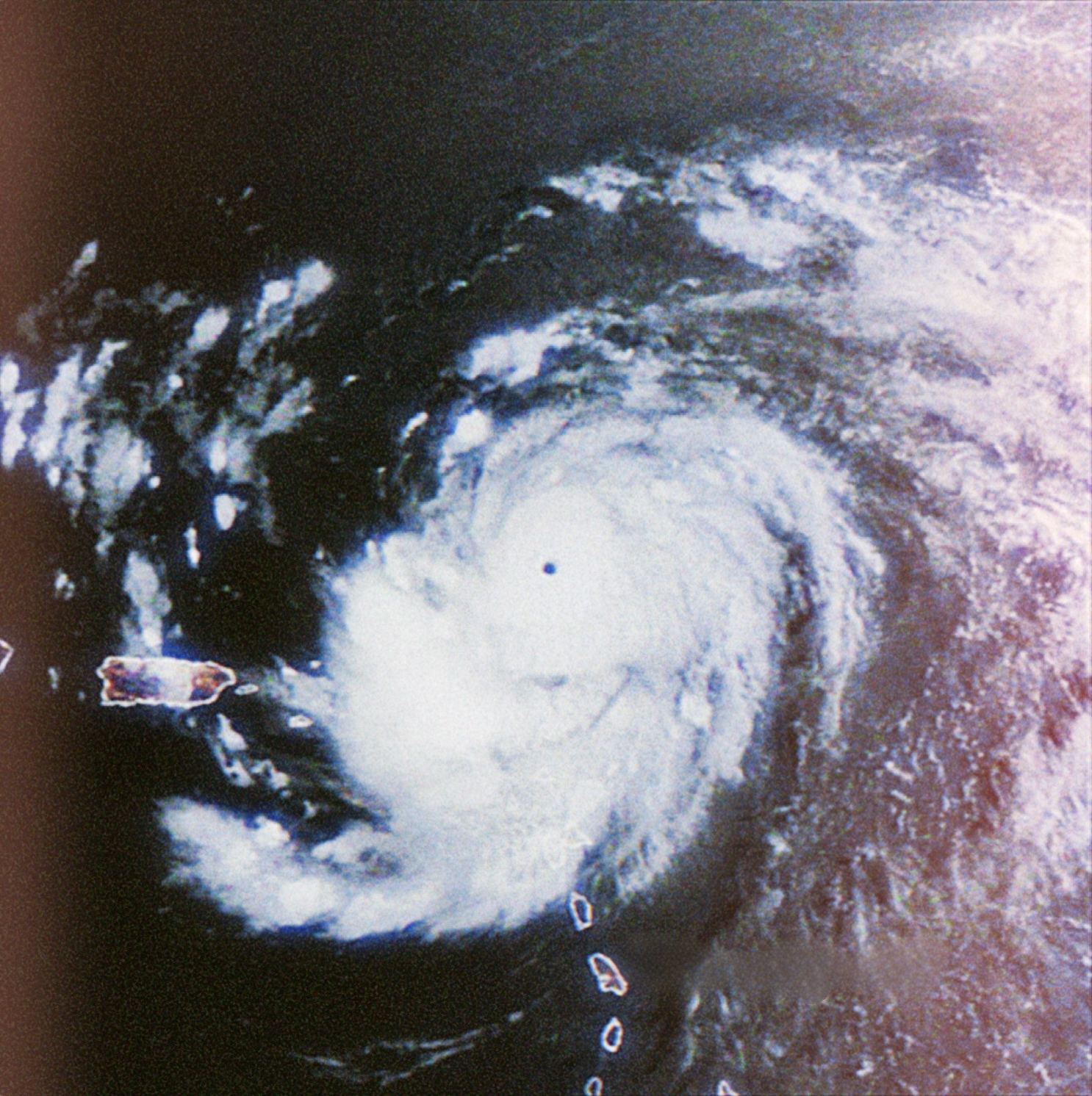
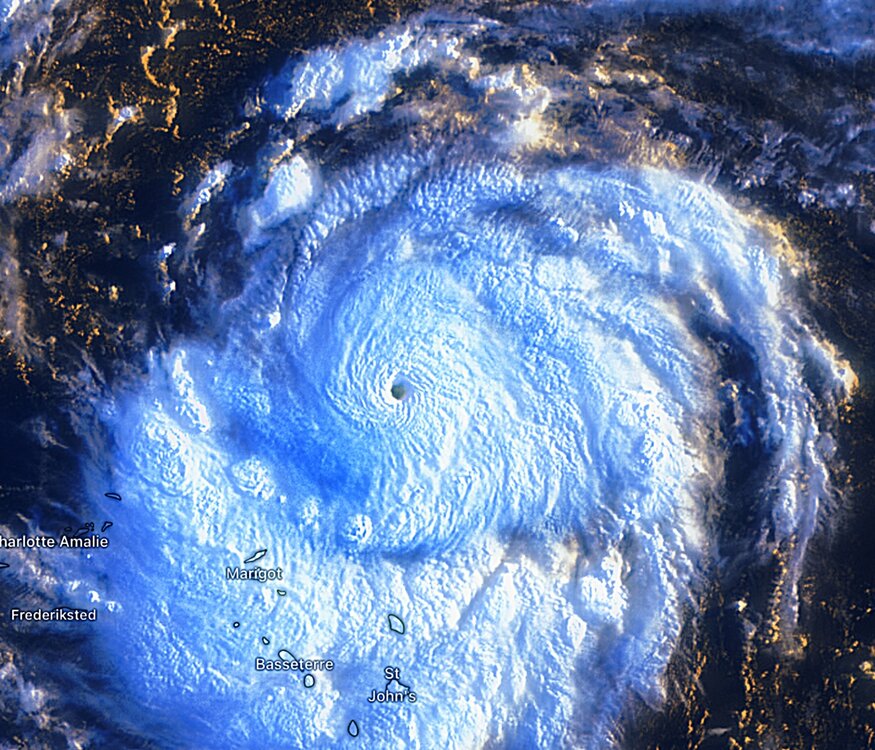
Eyewall really contracting in the visible . Might make a run at cat 5
-

Hurricane Erin - NOW 130 MPH AND 948 MB
TheDreamTraveler replied to BarryStantonGBP's topic in Tropical Headquarters
I like how NHC has Erin moving WNW but the past few hours she's been going due west. That's without wobbling or stair stepping. -
 My guess is that the stronger sea breeze in recent years has been also playing a role reducing the 90° days relative to the increases at other areas. Stronger sea breeze circulation South Shore of NYC and LI. Plus there have been several equipment moves at JFK since 1948. So it appears that the observations prior to 1995 were at warmer parts of the airport a little further from Jamaica Bay. Making it easier to record 90° days further from the sea breeze. The current location of the ASOS since 1995 is right on the water. JFK is so large that there is a significant difference in temperatures closer to the Ozone Park side than the current ASOS near the cooler 5 towns right on the Bay. See the full location history for this station using the Historical Observing Metadata Repository. Latitude Longitude History LATITUDE LONGITUDE PRECISION BEGIN DATE¹ END DATE¹ 40.63915 -73.7639 DDddddd 1996-05-01 Present 40.63915 -73.76401 DDddddd 1995-05-01 1996-05-01 40.65 -73.78333 DDMM 1948-07-01 1995-05-01 40.65 -73.783333 DDMM 1948-06-01 1948-07-01 Elevation History ELEVATION ELEVATION TYPE BEGIN DATE¹ END DATE¹ 2.7 GROUND 1996-05-01 Present 3.4 GROUND 1995-05-01 1996-05-01 4.9 GROUND 1982-01-01 1995-05-01 10.1 GROUND 1958-01-01 1982-01-01 9.1 GROUND 1951-01-01 1958-01-01 6.1 GROUND 1948-07-01 1951-01-01 4.9 GROUND 1948-06-01 1948-07-01 9.8 BAROMETRIC 1996-05-01 Present Relocation History RELOCATION DATE¹ .3 mi S 1957-12-18 Location Descriptions DESCRIPTION BEGIN DATE¹ END DATE¹ E SIDE JFK INTL AP MIDWAY BTWN RWYS 4L-22R/4R-22L AND RWYS 13L-31R/13R-31L 1995-06-27 Present ROOF OF INTL ARRIVALS BLDG WITHIN AND 1 MI S OF PO AT JFK AIRPORT 1991-06-13 1995-06-27 0 OF PO 1948-06-01 1948-07-01 Topography Descriptions TOPOGRAPHY BEGIN DATE¹ END DATE¹ JAMAICA BAY WITH NUMEROUS SMALL MARSH ISLANDS TO THE SOUTH AND SOUTHWEST. ATLANTIC OCEAN IS 5 MILES TO THE SOUTH SEPARATED BY A BARRIER SAND PENINSULA HOME TO THE ROCKAWAYS. TERRAIN AT AIRPORT COMPLEX IS FLAT WITH MUCH OF IT SANDFILL. HEAVILY POPULATED WITH CONGESTED CAR TRAVEL TO THE NORTH AND EAST. 1996-05-01 Present JAMAICA BAY W NUMEROUS SMALL MARSH ISLANDS. TERRAIN FLAT AND SANDFILL. HEAVILY POPULATED AND CONJESTED CAR TRAVEL TO N AND E 1991-06-13 1996-05-01
 -
-
53.9° Chilly
-
Hurricane Erin - NOW 130 MPH AND 948 MB
BarryStantonGBP replied to BarryStantonGBP's topic in Tropical Headquarters
F. CLOSEDG. C7
- Today
-
Just upgraded to cat 4
-
Hurricane Erin - NOW 130 MPH AND 948 MB
BarryStantonGBP replied to BarryStantonGBP's topic in Tropical Headquarters
OI LAD SHE’S A C4 NOW -
Looks like Erin made a small jog SW in latest image Now 120mph.
-
Hurricane Erin - NOW 130 MPH AND 948 MB
BarryStantonGBP replied to BarryStantonGBP's topic in Tropical Headquarters
GOOOOOOOOAAAAAAALLLLLLLL ERIN SCORED A FAT CAT 4 NOW COOK ME SOME MORE SCRAN Hurricane Erin Satellite | Buoys | Grids | Storm Archive ...NOAA HURRICANE HUNTERS FIND ERIN A DANGEROUS CATEGORY 4 HURRICANE... 5:50 AM AST Sat Aug 16 Location: 19.6°N 61.5°W Moving: WNW at 20 mph Min pressure: 948 mb Max sustained: 130 mph -
I wake up to see I missed again. An overnight storm complex left southwestern Schuylkill County in a flood warning this morning. Some personal weather stations recorded as much as 4 inches of rain. Sadly, it drifted southeast into Berks County.
-
Hurricane Erin - NOW 130 MPH AND 948 MB
BarryStantonGBP replied to BarryStantonGBP's topic in Tropical Headquarters
Been cooking right GET BACK IN THE KITCHEN ERIN AND MAKE ME SOME SCRAN It’s breakfast so gimme a full English with korma on the side anyway she’s been cooking a lot while i was asleep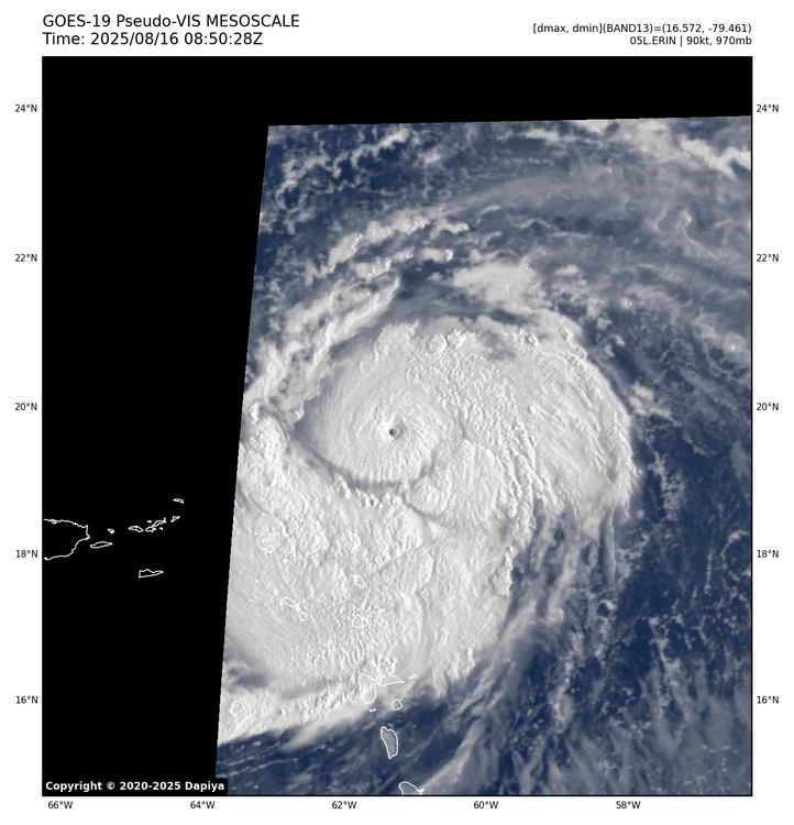

-
Hurricane Erin - NOW 130 MPH AND 948 MB
BarryStantonGBP replied to BarryStantonGBP's topic in Tropical Headquarters
BLOODY HELL I just woke up and saw Éowyn uh I meant Erin becoming a bloody category 3, and a mid-range one at that innit -
2025 Atlantic Hurricane Season
BarryStantonGBP replied to BarryStantonGBP's topic in Tropical Headquarters
OI LAD WE GOT OUR FIRST MAJOR -
Hurricane Erin - NOW 130 MPH AND 948 MB
BarryStantonGBP replied to BarryStantonGBP's topic in Tropical Headquarters
MATE WTF IS ON WITH THIS LASS DID SHE JUST DUNK HER HEAD IN KET IN AYIA NAPA Hurricane Erin Satellite | Buoys | Grids | Storm Archive ...ERIN RAPIDLY STRENGTHENING... ...OUTER RAINBANDS BEGINNING TO AFFECT THE NORTHERN LEEWARD ISLANDS... 5:00 AM AST Sat Aug 16 Location: 19.8°N 61.1°W Moving: WNW at 20 mph Min pressure: 955 mb Max sustained: 120 mph week. FORECAST POSITIONS AND MAX WINDS INIT 16/0900Z 19.8N 61.1W 105 KT 120 MPH 12H 16/1800Z 20.3N 63.3W 130 KT 150 MPH 24H 17/0600Z 21.1N 65.6W 130 KT 150 MPH 36H 17/1800Z 22.1N 67.5W 125 KT 145 MPH 48H 18/0600Z 23.3N 68.8W 120 KT 140 MPH 60H 18/1800Z 24.6N 69.8W 115 KT 130 MPH 72H 19/0600Z 26.2N 70.5W 110 KT 125 MPH 96H 20/0600Z 29.9N 70.9W 105 KT 120 MPH 120H 21/0600Z 34.7N 68.0W 95 KT 110 MPH -
It’s the scale
-

Hurricane Erin - NOW 130 MPH AND 948 MB
Windspeed replied to BarryStantonGBP's topic in Tropical Headquarters
He meant at the 925 mb flight level. Not at the surface. At any rate, faster than steady intensification continues, but the lid is about to come off. Expect rapid deepening through Saturday and high-end Category 4 type intensity until outer banding consolidates. Given the regional environment and outflow pattern, Erin most likely will grow into a large size hurricane by Tuesday. So expect several replacement cycles with periods of reintensification in-between. -

Hurricane Erin - NOW 130 MPH AND 948 MB
TriPol replied to BarryStantonGBP's topic in Tropical Headquarters
9...25??? Is that right? -
If it’s anything like the first half of last fall, I’m all for it. The winters just aren’t what they used to be around here (at least on the coastal plain) and by mid January, I’m usually thinking of much brighter skies and greener pastures! We really gotta do away with the whole daylight savings bs imo..that would really take a huge sting off of things.