All Activity
- Past hour
-
 buying medicine online in india: GenIndusPharma - indian pharmacy website
 -

Strong Nor'Easter/Hybrid Storm Late September 2026
Rjay replied to Rjay's topic in New York City Metro
Had loud thunder about an hour ago. ISP gusted to 54mph -

Strong Nor'Easter/Hybrid Storm Late September 2026
weathermedic replied to Rjay's topic in New York City Metro
61 mph gust recorded at Republic airport in Farmingdale Long Island -
.thumb.jpg.6a4895b2a43f87359e4e7d04a6fa0d14.jpg)
Central PA Autumn 2026
Yardstickgozinya replied to canderson's topic in Upstate New York/Pennsylvania
Area Forecast Discussion National Weather Service State College PA 342 AM EDT Sat Sep 26 2026 .WHAT HAS CHANGED... * Increased/darkened the sky cover grids across the board for the next 60 hrs * Increased winds and gusts slightly, especially over the east today and Sunday && .KEY MESSAGES... 1) Nor`easter will bring gusty winds and periods of rain for the first weekend of Fall && .DISCUSSION... KEY MESSAGE 1: Nor`easter will bring gusty winds and periods of rain for the first weekend of Fall Big storm will tuck itself between Long Island and NJ for the weekend. It will deepen to about 990mb depending on your numerical model/ensemble member of choice. At least one solution has the sfc low getting as far W as the Delaware River. Most keep the western extent of it`s wobbly track around the Jersey Shore. The wind already made a gust near 30KT at Wellsboro (KN38) around midnight and VAD Wind Profile from KCCX has 50KT winds not even 4kft aloft. KPHL has just gusted to 40KT (which is wind advy level). We may have to consider a wind advy, but current and previous thinking is that most gusts should stay in the 30s over our CWA. Lancaster, Lebanon, Schuylkill and Sullivan Counties are the most-possible locations to get a 40+KT gust. The gradient stays similar in tightness from mid-day today through Sunday evening. Very light rainfall has already begun at PHL, and will work back to the west through the day. Expect some drops to hit the ground before 10 AM, and perhaps before 8 AM, in Lancaster Co. QPF is minor. The highest rainfall will be later tonight and through the day Sunday. Storm total numbers range from near 1" in New Holland and Dushore to less than a tenth of an inch from State College west. As the nor`easter lifts to the northeast later Monday, conditions should steadily improve with temperatures poised to rebound above the historical average for the end of September. && .AVIATION /07Z SATURDAY THROUGH WEDNESDAY/... Prevailing VFR flight cats through the night with increasing high to mid level clouds from southeast to northwest. Localized vis restrictions may occur in valley fog later tonight, but the probability of prolonged restrictions at any TAF sites is too low to include in the forecast. LLWS is expected throughout the ZNY airspace tonight as a 45-60 knot low level jet moves into the area on the west-side of a powerful Nor`easter. Surface winds increase to 10-15 knots out of the northeast after sunrise and gusts of 25-30 knots are expected for much of the day. The highest gusts will occur at southeastern sites. Light rain will approach MDT and LNS during the afternoon, but the rest of the region should remain dry into the the first part of Saturday night. A strong low-level jet will remain in place over much of Central PA through much of Saturday night, but the strongest winds may remain just above 2000 feet for most locations. Because of this, LLWS has been kept out of most of the TAFs. After a break in the rain during the evening, another round of steady rain moves in from the east as the surface low moves closer to the region. The biggest uncertainty in the forecast is just how far west this rain makes it during the day on Sunday. Ceilings should gradually drop to MVFR at MDT and LNS as the steadier rain moves in. https://forecast.weather.gov/product.php?site=CTP&issuedby=CTP&product=AFD&format=CI&version=1&glossary=1&highlight=off -

October Comes Early: Late September Multi-Hazard Hybrid Storm
CT Rain replied to WxWatcher007's topic in New England
FRG at 53 knots. Maybe OKX will issue the high wind warning now? -
online shopping medicine: GenIndusPharma - medicine purchase
-
Polo is undergoing an EWRC. The inner eye is shrinking rapidly. The concentric outer eyewall appears to be taking off, and convection remains intense. Though, due to the chaotic nature of these processes, it's futile to try and forecast how fast these will complete and the larger eye clear out entirely, but this one may not take very long. I am basing this on the intensity of convection that persists and the symmetrical structure of the CDO. Once the outer eyewall is fully dominant, it shouldn't take long for sinking airmass to suppress remnant convection of the old and clear it out. SSTs are still very warm, though OHC at depth is decreasing. Polo's motion seems fast enough that upwelling shouldn't be much of an issue for now. SSTs do drop off in the forecast when Polo is moving poleward, which will bring down intensity regardless. Southwesterly shear should also begin to increase, which may help get some drier airmass into the core and put an end to its many hours of Cat 5/upper Cat 4 durations of intensity. Polo may be able to maintain Cat 3 status into the Baja Peninsula. We are still several days away from that, however.
-

Strong Nor'Easter/Hybrid Storm Late September 2026
EasternLI replied to Rjay's topic in New York City Metro
Analysis recorded the center at 987mb as of 06Z today. -

October Comes Early: Late September Multi-Hazard Hybrid Storm
ineedsnow replied to WxWatcher007's topic in New England
6z Nam would be fun - Today
-
https://canamcrosscare.com/# canadian drug pharmacy
-

Strong Nor'Easter/Hybrid Storm Late September 2026
Dan76 replied to Rjay's topic in New York City Metro
Winds are cranking and no HWW smh . -

Strong Nor'Easter/Hybrid Storm Late September 2026
nycwinter replied to Rjay's topic in New York City Metro
upton lowered rain totals for 2-3 inches for the city when earlier it was 3-5 inches.. -

Strong Nor'Easter/Hybrid Storm Late September 2026
Parterre replied to Rjay's topic in New York City Metro
Bone dry here in upper Manhattan. -
indian pharmacy online: india rx - drug store online
-

E PA/NJ/DE Autumn 2026 Obs/Discussion
The Iceman replied to PhiEaglesfan712's topic in Philadelphia Region
Maybe it’s just because there’s still so many leaves but it sounds like the wind is overperforming out there… wish I had an anemometer. Trenton airport has gusted over 40 several times overnight though which is pretty impressive this far inland especially since it’s not the peak. Saw some impressive gusts at the shore too think the highest I saw was 77 mph. -
canadian pharmacy official website and canadian pharmacy comparison canada rx pharmacy https://www.google.si/url?q=https://canamcrosscare.com canadian pharmacy world or https://boyerstore.com/user/hkgvfoatfk/?um_action=edit canadian drugstore online [url=http://cse.google.com.gh/url?q=https://canamcrosscare.com]cipa canada online pharmacy[/url] cipa canada online pharmacy or [url=http://dnp-malinovka.ru/user/xwbytldmhv/?um_action=edit]safe online pharmacies in canada[/url] canada pharmacy world
-

October Comes Early: Late September Multi-Hazard Hybrid Storm
vortex95 replied to WxWatcher007's topic in New England
Another item, MQE ended up w/ 5.76" of rain for the Perfect Storm in 1991, far more than any model showed. Of course, no hires models then, but what the ECMWF is showing does makes sense when you have extended duration big ENE fetch moist flow. -
October Comes Early: Late September Multi-Hazard Hybrid Storm
vortex95 replied to WxWatcher007's topic in New England
But give it some "TYME!!!" It has lots of it to meander "down there." -
October Comes Early: Late September Multi-Hazard Hybrid Storm
vortex95 replied to WxWatcher007's topic in New England
What about 99 bottles of BEER on the wall? -
October Comes Early: Late September Multi-Hazard Hybrid Storm
ineedsnow replied to WxWatcher007's topic in New England
LFG!! -
October Comes Early: Late September Multi-Hazard Hybrid Storm
vortex95 replied to WxWatcher007's topic in New England
Sct embedded tstms likely. CAPE not bad in SNE for a Nor'easter today and Sunday. So bring down those winds as @ineedsnow would say! -
October Comes Early: Late September Multi-Hazard Hybrid Storm
vortex95 replied to WxWatcher007's topic in New England
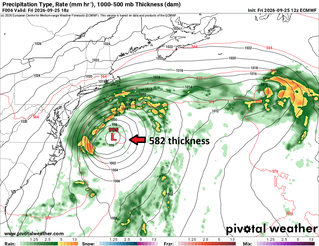
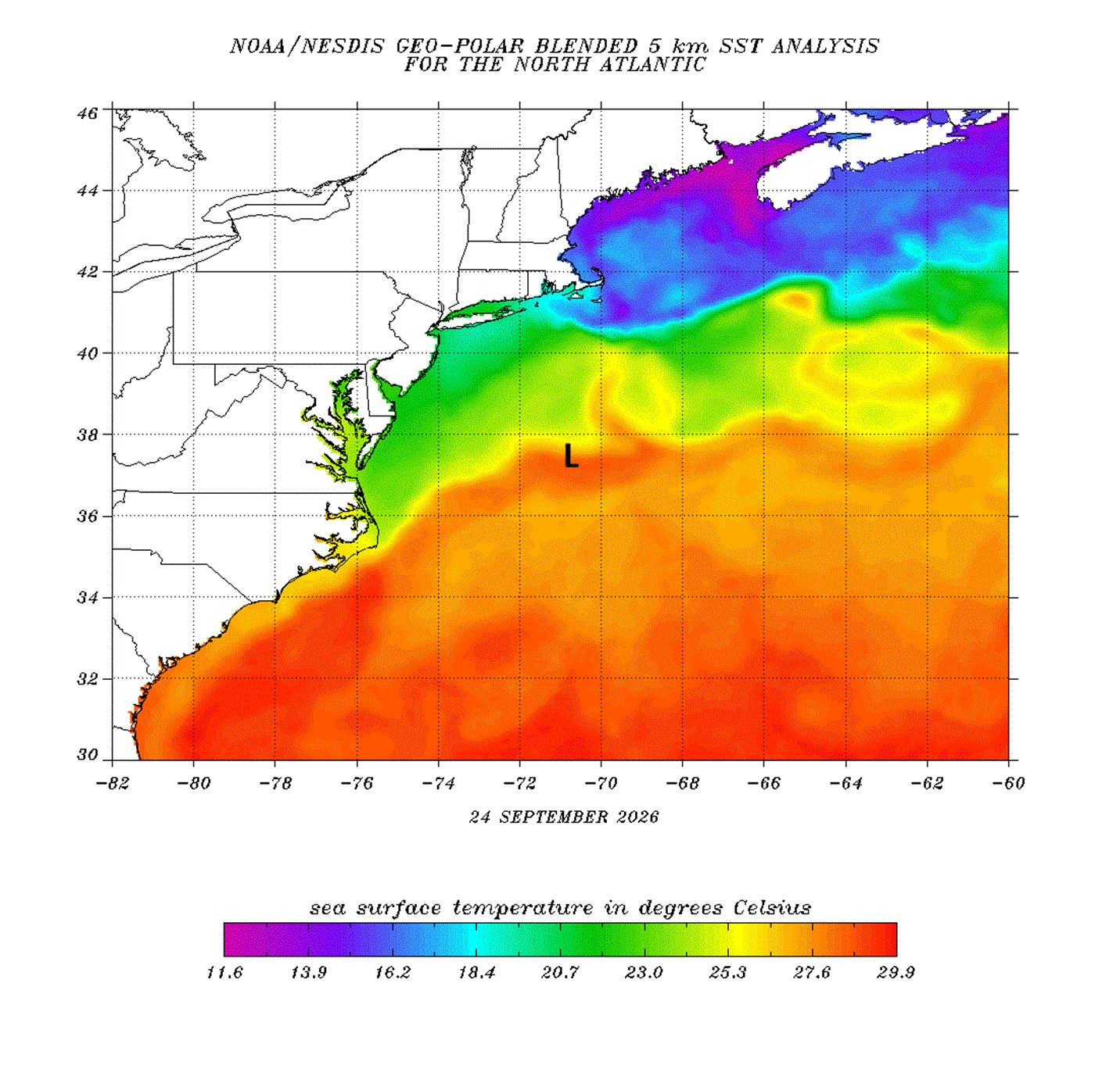
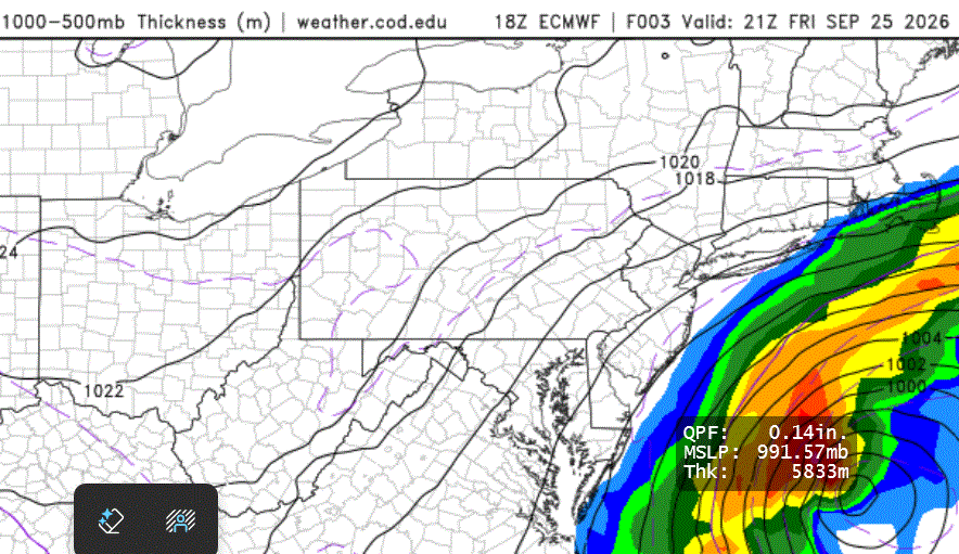
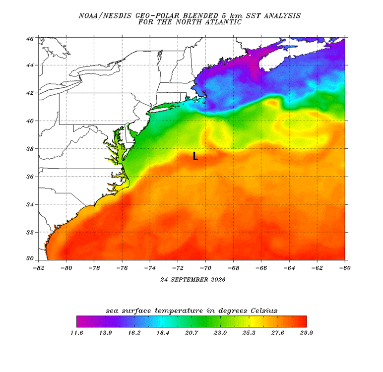
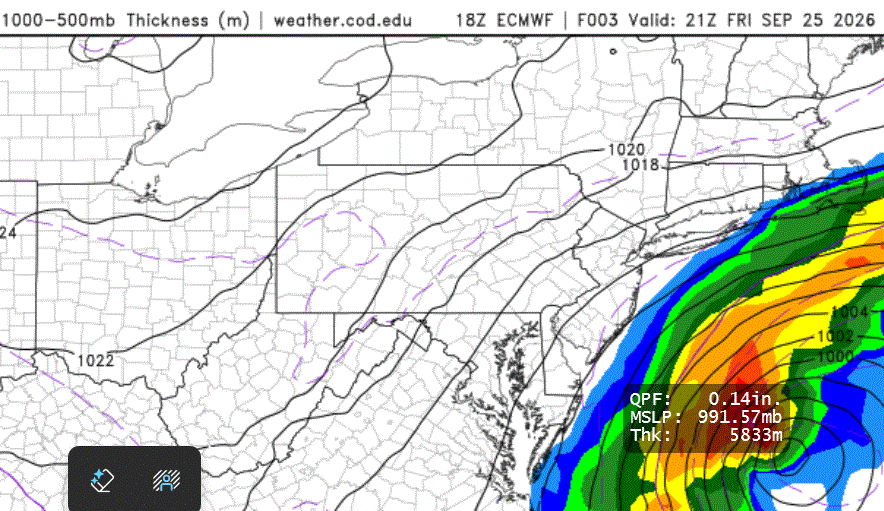
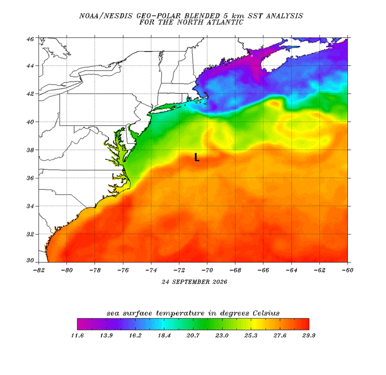
This is not your typical "cold" ET storm evolution. The initial surface low development was S of the 576 dm 1000-500 thickness line and by 25/18z, a small 582 closed thickness pool had formed over the low center (see ECMWF 12z 06 hr and 18z 03 hr forecast attached). This is a much higher thickness than what you would find in a typical strong ET storm development near 37N in late September in this region off the U.S. East Coast. A 582 thickness pool is what you commonly see on the global models over a mature hurricane, so I would be cautious here as this is an outlier case and conventional rules of thumb may not apply. This is why I mentioned in an earlier post that one needs to think outside the box here. Yes, I know that this mid-level warm pool alone does not make it even close to a ST system currently, but you have to admit this is unusually warm for initial strong baroclinic development and a high launching pad, relativity speaking. Nothing quite like this (at least in the last 50 yr) has occurred in September in this particular region when a strong ET low develops during the near peak climo of SSTs that are 2-4 C above average and the low meanders for days in the same region close to the coast. I attached the SSTs analysis and the approximate position of the surface low at 25/18z. It is over SSTs more than enough to support ST transition and is going nowhere fast the next 72 hr off the Mid-Atlantic coast, so I would not let one's guard down here. The closest analog is the Perfect Storm Oct-Nov 1991 and the hurricane that formed from it eventually, so such a scenario here is not unprecedented. If I recall correctly, a recon was flown into that system when the transition had occured and they found a 981 pressure and 88 kt FL winds.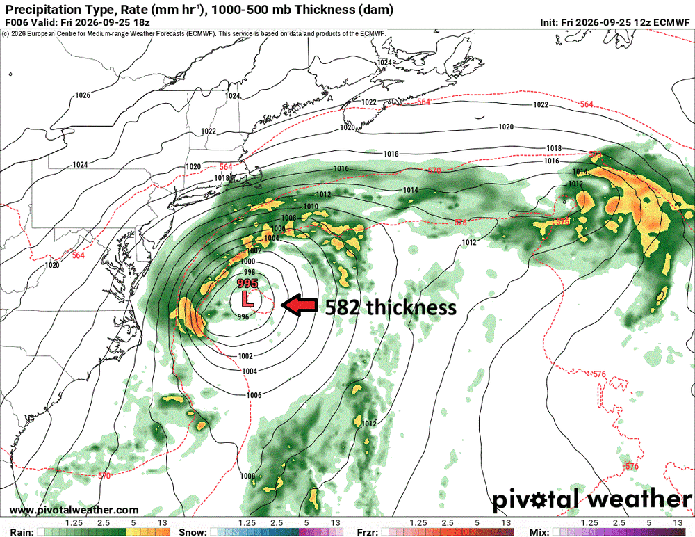
-
October Comes Early: Late September Multi-Hazard Hybrid Storm
vortex95 replied to WxWatcher007's topic in New England
Good! So much rain in Weymouth, it will "drown out" @CoastalWx's constant boring whining nonsense! LOL -
2026 Atlantic Hurricane Season
vortex95 replied to Stormchaserchuck1's topic in Tropical Headquarters
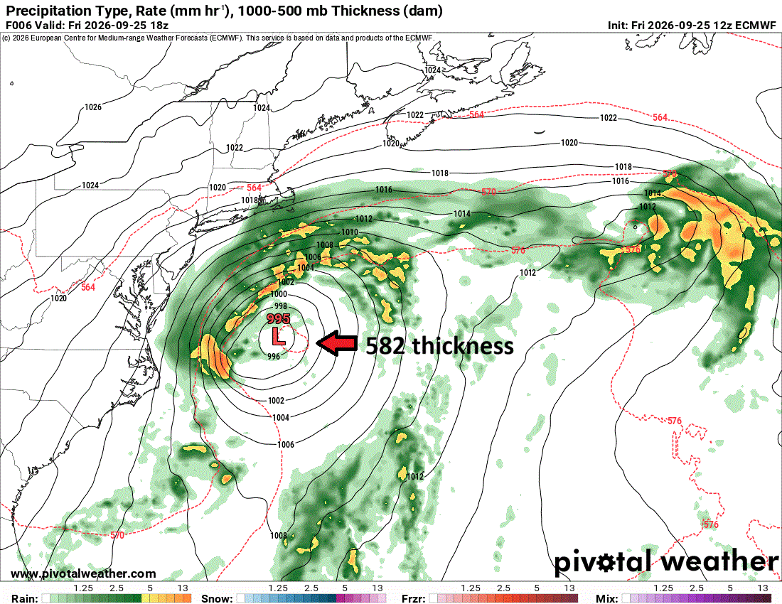
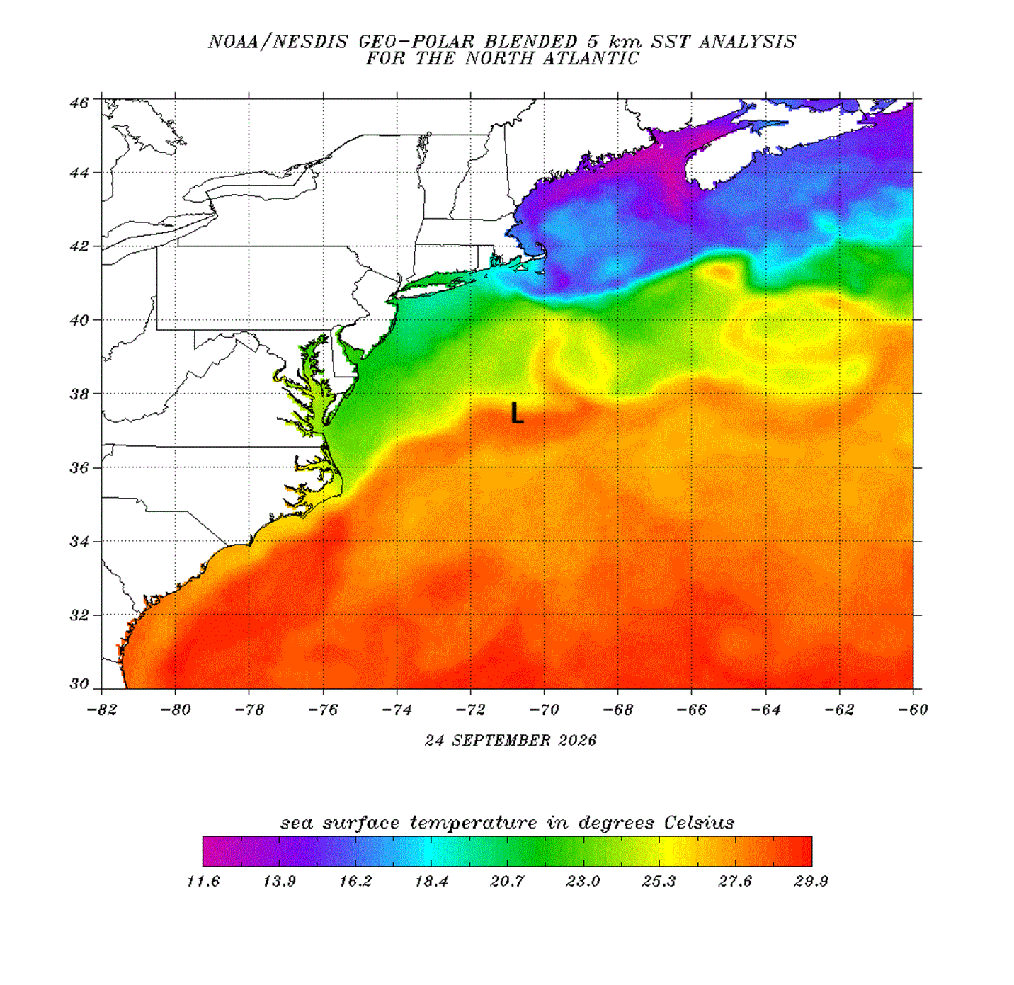
Concerning the East Coast storm, I wanted to point out something I can not recall seeing in this region in Sep. This is not your typical "cold" ET storm evolution. The initial surface low development was S of the 576 dm 1000-500 thickness line and by 25/18z, a small 582 closed thickness pool had formed over the low center (see ECMWF 12z 06 hr and 18z 03 hr forecast attached). This is a much higher thickness than what you would find in a typical strong ET storm development near 37N in late Se in this region off the U.S. East Coast. A 582 thickness pool is what you commonly see on the global models over a mature hurricane, so I would be cautious here as this is an outlier case and conventional rules of thumb may not apply. This is why I mentioned in an earlier post that one needs to think outside the box here. Yes, I know that this mid-level warm pool alone does not make it even close to a ST system currently, but you have to admit this is unusually warm for initial strong baroclinic development and a high launching pad, relativity speaking. Nothing quite like this (at least in the last 50 yr) has occurred in Sep in this particular region when a strong ET low develops during the near peak climo of SSTs that are 2-4 C above average and the low meanders for days in the same region close to the coast. I attached the SSTs analysis and the approximate position of the surface low at 25/18z. It is over SSTs more than enough to support ST transition and is going nowhere fast the next 72 hr off the Mid-Atlantic coast, so I would not let one's guard down here. The closest analog is the Perfect Storm ET low Oct-Nov 1991 and the hurricane that formed from it eventually, so such a scenario here is not unprecedented. A recon was flown into that system when the transition had occured and they found a 981 pressure and 88 kt FL winds.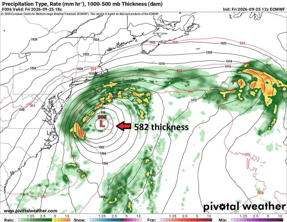
-

Strong Nor'Easter/Hybrid Storm Late September 2026
TriPol replied to Rjay's topic in New York City Metro
FWIW, I was being sarcastic. The storm is still off of the Carolinas. It's taking absolutely forever to get up here. What we have now are the outer bands. The main event is tomorrow night.