All Activity
- Past hour
-
The circulation patterns have changed since the 1950s. So areas east of the Hudson have more onshore flow influence and rainfall. So the most impressive records for heat in recent years have been found in NJ. We can’t use NYC to compare to those days since they changed how the measure temperatures in 1995 under the trees instead of out in the open in the 1940s and 1950s.
-
The got a 2024 first round pick back
-
wow I wish I was alive then, this must have been absolutely amazing-- look at that 96 high on August 16 with 0.88 of rain, who said it can't get hot and rain a lot at the same time ;-)
-
Hopefully
-
If the storms miss west Thursday . And the blistering pattern coming next few weeks. Everything will very quickly go Stein
-
NYC August 1944 August 10 97 66 0.00 0.0 August 11 102 74 0.00 0.0 August 12 97 75 0.00 0.0 August 13 96 76 0.00 0.0 August 14 95 77 0.00 0.0 August 15 95 75 0.00 0.0 August 16 96 73 0.88 0.0 August 17 95 76 0.00 0.0
-
False black widow? Maybe @weatherwiz would know


-
Chris, isn't the consecutive 95+ streak at Central Park from 1944 at 8 days? That's why I listed 1944 as the start of the super hot cycle that ended in 1955. 1944-1955 is twelve years and 5 of those summers were extremely hot. It mirrors the 12 year period from 1991-2002 which also had 5 really hot summers. Maybe climate change will add more to this intense heat and the next time we get this very hot 12 year cycle climate change superimposed on top of this 12 year cycle will break the records that were set in both those cycles? The records I'm looking at are: 1944 8 consecutive 95+ days NYC 1948 3 straight days of 100+ at JFK 1949 5 days of 99+ at NYC (the 8 days of 100+ at EWR was already exceeded in 1993, in the next very hot cycle). 1953 a 12 day and a 7 day super heatwave at NYC with 4 days of 100+ evenly split between the two superheatwaves, which included the highest temperature ever recorded in September at 102. 1955 16 95+ days at NYC and 14 95+ days at LGA Second hot cycle 1991 39 90+ days at NYC 1993 39 90+ days at NYC (tied 1991), 3 straight days of 100+ at NYC during a 10 day super heatwave, 9 days of 100+ at EWR, including 5 in a row (beat the record from 1949 during the last very hot cycle) 1995 July had our area's highest heat index on record (at LGA) followed by the driest August on record with widespread wildfires 1999 Two super heatwaves of 9 and 8 days length in July, exceeded 100 areawide and set records for number of 90+ days in July 2002 Two super heatwaves of 8 and 7 days length in July and August
-
While those 1950s heatwaves were intense while they were occurring, they didn’t t have the lasting power of extended stretches of 95°+ heat that has become common during the 2010s and 2020s. This is the top 11 for 95° days at Newark. 1955 only had 17 days reaching 95° in 1955. Newark has exceed that number twice since 2021. Last summer Central NJ had 21 days which surpassed 2002 and 1955. Time Series Summary for NEWARK LIBERTY INTL AP, NJ - Jan through Dec Click column heading to sort ascending, click again to sort descending. 1 1993 25 0 2 2010 21 0 3 2022 20 0 - 1988 20 0 - 1944 20 0 4 2021 18 0 5 2012 17 0 - 2011 17 0 - 2002 17 0 - 1955 17 0 6 1949 16 0 7 2005 14 0 - 1953 14 0 8 2016 13 0 - 1999 13 0 - 1991 13 0 - 1987 13 0 9 1994 12 0 - 1983 12 0 - 1966 12 0 10 2018 11 0 - 1973 11 0 11 2024 10 0 Time Series Summary for HIGHTSTOWN 2 W, NJ - Jan through Dec Click column heading to sort ascending, click again to sort descending. 1 2024 21 2 2 2002 17 0 3 1955 16 8 4 1953 14 0 5 2021 13 0 - 2018 13 1 - 2016 13 2 - 2010 13 4 - 1988 13 0 - 1949 13 0
-
Nearest sun is CT or Pittsburg
-
I would have preferred that they ate some of the deal to got a top prospect back, or a bonafide SP.
-
Okay…I believe you.
-
Maybe there was some cyclical factor that made the period from 1944-1955 exceptionally hot? And maybe that cyclical factor repeated itself between 1991 and 2002? Note that both periods were 12 years in length...... I don't know about the other summers but I can list the exceptionally hot ones from both 12 year periods: 1944 1948 1949 1953 1955 and 1991 1993 1995 1999 2002 hmmm both 12 year periods had 5 extremely hot summers.....
-
Specifically 1953 and 1955. I added more to the post Tony. Although we can also add in 1948 and 1949 which were exceptionally hot too. 1949 8 100+ days at Newark only exceeded in 1993 with 9. NYC 5 days of 99+ at NYC never matched or exceeded (and 4 days of 100+ in 1953). Incidentally, the great 1953 heatwave and historic number of 95+ days in 1955 at both NYC and LGA hasn't been matched since either. I agree that climate change is changing our climate, but I don't think it's making our extremely hot days any hotter, it's increasing the mins and making it wetter. Otherwise why is the 95+ record at both LGA and NYC still from 1955?
-
Which periods of the 50s are you referring to Liberty? Just those two? Otherwise some below normal / wet sumemr months in the 50s (area-wide)
-

2025-2026 ENSO
40/70 Benchmark replied to 40/70 Benchmark's topic in Weather Forecasting and Discussion
I think CC is going to impact the tropics in the same manner that it is winter in terms of the greater degree of variance...ie "all of nothing". When conditions are favorable, it will undoubtedly be hyper active with instense storms, but I think there will be some instances where it will result in greater shear. -
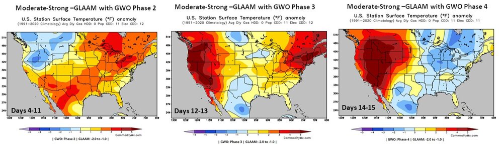
This progression might indeed happen, heat mid week, followed by a couple days of relative cooling , then a heat wave next week ( worse North of us ) and then moderation again, matching the global wind progressions. Note the worst of the heat moving back West by days 14 to 15.
-
2025-2026 ENSO
40/70 Benchmark replied to 40/70 Benchmark's topic in Weather Forecasting and Discussion
Okay, no one is calling for hyper active. -
I wasn't alive in the 50s when those historic heatwaves occurred in 1953 and 1955 that haven't been matched since, but I was alive in the 1990s especially years like 1991 and 1993 when it was hotter here with less rain and more sunshine. I feel like our springs have gotten cooler and wetter since then. Central NJ has always been a heat paradise lol. Incidentally, the great 1953 heatwave and historic number of 95+ days in 1955 at both NYC and LGA hasn't been matched since either. I agree that climate change is changing our climate, but I don't think it's making our extremely hot days any hotter, it's increasing the mins and making it wetter. Otherwise why is the 95+ record at both LGA and NYC still from 1955?
-
This is also a Sonoran heat release pattern fwiw
-
I sincerely hope you’re right as I want a quiet season for a change. But “anyone that’s been paying attention knows we’re not coming anywhere these numbers”?? Named Storms: 15-19Total Hurricanes: 7-9Major Hurricanes: 2-3ACE Index: 120-150 Based on what are you saying you know we’ll be nowhere close to these mainly only slightly above avg #s? We’re headed toward a weak Niña per RONI, which favors more active than avg and Atlantic temps are near the 1991-2020 avg, not cool.
-
Yes I would like to see a traditional 40s and 50s style heat ridge. I think climate change is messing with our ridges and making it more wet and less hot here in the summer so maybe we can reverse that now.
-
it's different dry vs wet. I have a really bad mold allergy problem and I sneeze too much to be able to sleep if the air is really moist.
-
Interesting in 2024 and 21 the ridge position switched and trended north over time witihin this timeframe, while this time appears to be stable. We shall see. That strong storm over the plains ND is pumping the flow SW and building the ridge.
-
we really need to build houses like they do in the southwest, instead of these brick ovens people live in.


.thumb.png.4150b06c63a21f61052e47a612bf1818.png)