All Activity
- Past hour
-
Does anyone have the gefs?
-

Central PA Winter 25/26 Discussion and Obs
Itstrainingtime replied to MAG5035's topic in Upstate New York/Pennsylvania
100% correct- the vast majority of precip will last about 6 hours in any given location. Freezing drizzle will follow. Merry Christmas everyone! -
Mine says 3-5 while the snow totals for select towns says 4-7 lol
-
My point and click says 5-10”
-
Next Friday couple be a redo of tomorrow night. Definitely has potential from that wave coming down with the arctic front!
-
Apple weather app.
-

26th-27th event, coming at us like a wounded duck.
Sey-Mour Snow replied to Go Kart Mozart's topic in New England
I could see locally 8-10” jack somewhere that gets lucky -
WWA now. Figures with models trending downward. However more ice will probably cause more issues had we just had more snows.
-
Is that on am app or something?
-

26th-27th event, coming at us like a wounded duck.
EastonSN+ replied to Go Kart Mozart's topic in New England
Updated map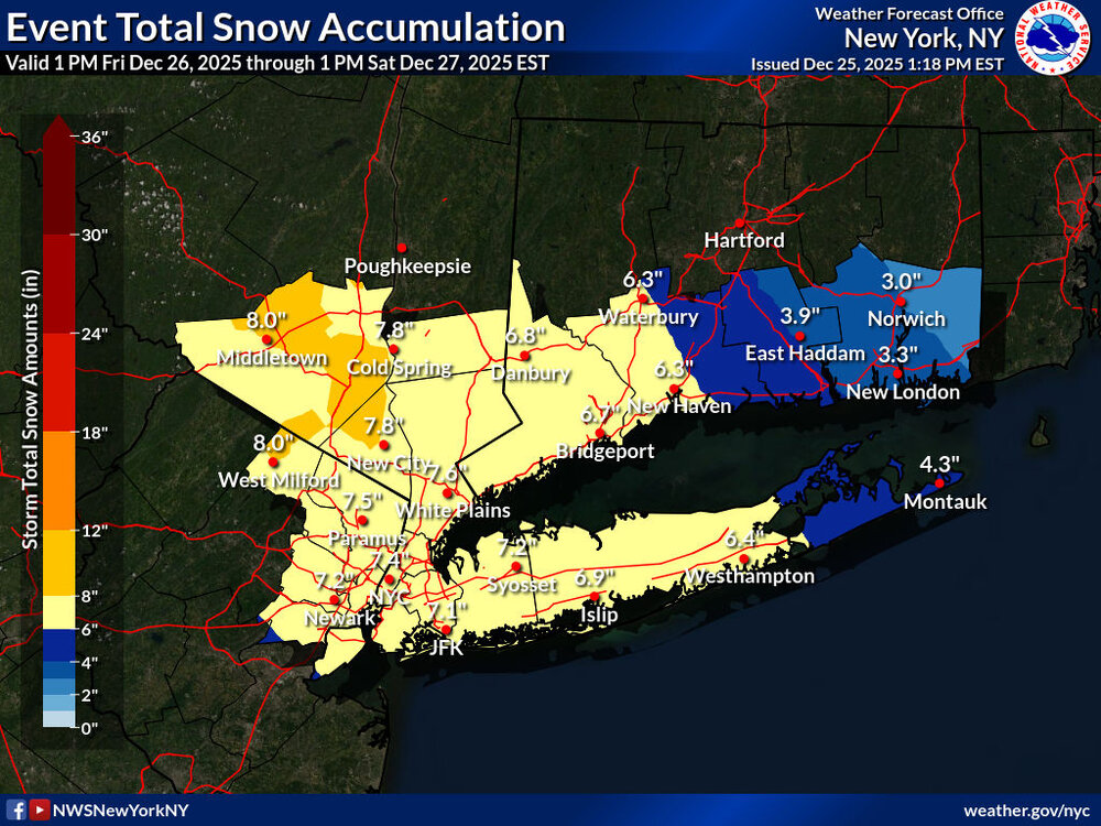
-
Very toasty Christmas overall, record breaking warmth southwest and central
-

26th-27th event, coming at us like a wounded duck.
CoastalWx replied to Go Kart Mozart's topic in New England
I’ll sell 10-15+. -

26th-27th event, coming at us like a wounded duck.
kdxken replied to Go Kart Mozart's topic in New England
Enjoy the e coli for Christmas. -

26th-27th event, coming at us like a wounded duck.
Damage In Tolland replied to Go Kart Mozart's topic in New England
I hope the city can get a good deal of snow.. but I’ve been in this scenario where so many times thinking I was safe and gonna do well and ended up wearing a hard hat . It’s where the dumbfounded term originated on the board -

26th-27th event, coming at us like a wounded duck.
Ginx snewx replied to Go Kart Mozart's topic in New England
Happy Happy birthday -
26th-27th event, coming at us like a wounded duck.
EastonSN+ replied to Go Kart Mozart's topic in New England
Wsw for Fairfield County CT. URGENT - WINTER WEATHER MESSAGE National Weather Service New York NY 119 PM EST Thu Dec 25 2025 CTZ005-009-NJZ002-004-006-103>108-NYZ067>075-078-080-176>179-260900- /O.UPG.KOKX.WS.A.0004.251226T2100Z-251227T1800Z/ /O.NEW.KOKX.WS.W.0003.251226T2100Z-251227T1800Z/ Northern Fairfield-Southern Fairfield-Western Passaic-Eastern Passaic-Hudson-Western Bergen-Eastern Bergen-Western Essex- Eastern Essex-Western Union-Eastern Union-Orange-Putnam-Rockland- Northern Westchester-Southern Westchester-New York (Manhattan)- Bronx-Richmond (Staten Island)-Kings (Brooklyn)-Northwest Suffolk- Southwest Suffolk-Northern Queens-Northern Nassau-Southern Queens- Southern Nassau- 119 PM EST Thu Dec 25 2025 ...WINTER STORM WARNING IN EFFECT FROM 4 PM FRIDAY TO 1 PM EST SATURDAY... * WHAT...Heavy snow expected. Total snow accumulations between 4 and 8 inches. * WHERE...Portions of southern Connecticut, northeast New Jersey, and southeast New York. * WHEN...From 4 PM Friday to 1 PM EST Saturday. * IMPACTS...Travel could be very difficult. The hazardous conditions could impact the Friday evening commute. PRECAUTIONARY/PREPAREDNESS ACTIONS... If you must travel, keep an extra flashlight, food, and water in your vehicle in case of an emergency. Check local Department of Transportation information services for the latest road conditions. && -

-
WS Watch to a WWA here. 1-3 snow/sleet + glaze of ice. Kinda expected. Hard to fight both WAA and the east wind.
-
02-004-006-103>108-NYZ067>075-078-080-176>179-260900- /O.UPG.KOKX.WS.A.0004.251226T2100Z-251227T1800Z/ /O.NEW.KOKX.WS.W.0003.251226T2100Z-251227T1800Z/ Northern Fairfield-Southern Fairfield-Western Passaic-Eastern Passaic-Hudson-Western Bergen-Eastern Bergen-Western Essex- Eastern Essex-Western Union-Eastern Union-Orange-Putnam-Rockland- Northern Westchester-Southern Westchester-New York (Manhattan)- Bronx-Richmond (Staten Island)-Kings (Brooklyn)-Northwest Suffolk- Southwest Suffolk-Northern Queens-Northern Nassau-Southern Queens- Southern Nassau- 119 PM EST Thu Dec 25 2025 ...WINTER STORM WARNING IN EFFECT FROM 4 PM FRIDAY TO 1 PM EST SATURDAY... * WHAT...Heavy snow expected. Total snow accumulations between 4 and 8 inches. * WHERE...Portions of southern Connecticut, northeast New Jersey, and southeast New York. * WHEN...From 4 PM Friday to 1 PM EST Saturday. * IMPACTS...Travel could be very difficult. The hazardous conditions could impact the Friday evening commute.
-
Will be a dicey situation. Snow should come in between 4-6pm. They should be able to get it. Then again it’s HPN. Small runway, etc.
-

26th-27th event, coming at us like a wounded duck.
mob1 replied to Go Kart Mozart's topic in New England
Sad, but true. Mesos will be really fun starting tonight as they start showing the potential best banding and forcing, someone between the LHV and western CT will likely exceed 10". -
Northeast Suffolk-Southeast Suffolk- 119 PM EST Thu Dec 25 2025 ...WINTER STORM WARNING IN EFFECT FROM 7 PM FRIDAY TO 1 PM EST SATURDAY... * WHAT...Heavy snow expected. Total snow accumulations between 4 and 8 inches. Highest amounts are expected from near Riverhead on westward. The north and south forks will likely see a sharper gradient with amounts 2 to 5 inches. * WHERE...Northeast Suffolk and Southeast Suffolk Counties. * WHEN...From 7 PM Friday to 1 PM EST Saturday. * IMPACTS...Travel could be very difficult. The hazardous conditions could impact the Friday evening commute.
-
Winter storm warning area wide including all long island
-
26th-27th event, coming at us like a wounded duck.
Damage In Tolland replied to Go Kart Mozart's topic in New England
NYC is going to get a lot of sleet . This NE push still not caught up on models -
Merry Christmas to all.... (More like an Epiphany gag, but by January 6 we'll be too busy tracking a winter storm)


.thumb.jpeg.f5c6ba9d911ec96b3b124f8606aee58e.jpeg)


