All Activity
- Past hour
-
Practically hot almost.
-
Just enjoy deep summer coming up. Put the chainsaw down and head to the beach.
-
67 / 65 still an onshore focus keeping the June gloom cloud magnet overhead the brunt of the morning into early afternoon. Once the sun returns heats up quickly to the mid / uppper 80s. Those with more prolonged periods of sun could touch 90. Scattered storms overnight. Sunnier Sunday heats up upper 80s to low 90s in the hot spots again with scattered storms overnight. Mon looks the hottest of the week (till the 6/7th) with enough sun ahead of any storms, low perhaps some mid 90s in the hot spots. Tue storms may be abit more in coverage, otherwise hot/humid with in/out sun. Wed - Sat : Looks like a nice stretch (perhaps the nicest) of the summer beach days , dry, sunny, warm mainly mid - upper 80s with a mainly clear and dry fourth of July. Euro is coolest for the 4th/5th keeping the area low 80s or lower. Beyond there hotter towards the 7th and we'll see how the ridge lines up , overall hotter. 6/28 - 7/1 : Hot/humid possible storms (focus Sat PM, Mon PM / Tue) 7/2 - 7/5 : Warm, dry , clear mainly 80s 7/6 - 7/7: maybe a bit wetter 7/7 - beyond : Turning Hotter
-
Anything 60+ is mild in June.
-
All hot all the time having a tough time spinning this one.

-
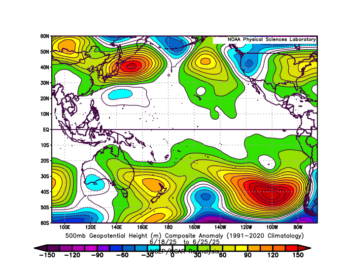
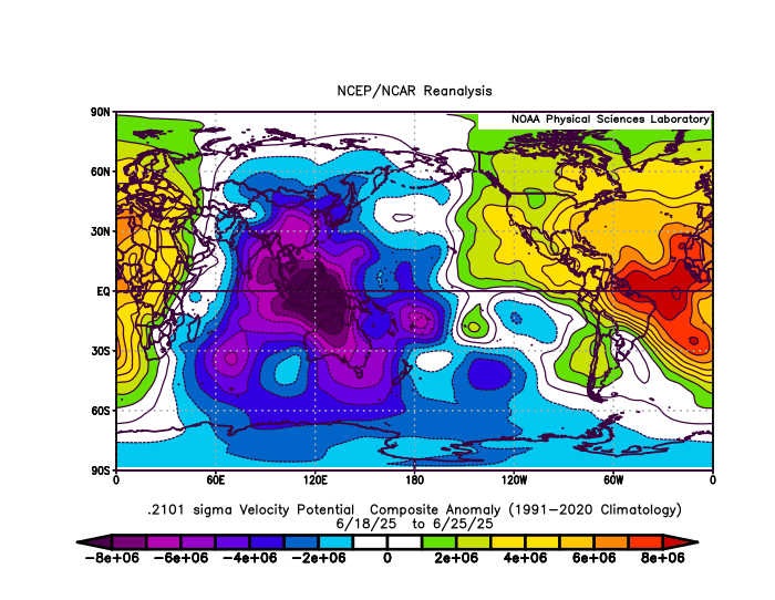
The record ridge over the WPAC driving the steep -PDO decline has resulted in the earliest end to the rainy season that the west of Japan has ever seen. Also part of the pattern which drove the all-time June heat the heat in the East a few days ago. So even with a neutral ENSO it’s creating a very strong La Niña background pattern. Very impressive forcing in the MJO 5 region. https://japannews.yomiuri.co.jp/society/general-news/20250627-266163/ Rainy season appears to have ended in various parts of western Japan, it was announced Friday. According to the Japan Meteorological Agency, the season ended in the southern Kyushu region 18 days earlier than usual and 19 days earlier than last year. In the northern Kyushu region, the season ended 22 days earlier than usual and 20 days earlier than last year. The Shikoku region saw the season finish 20 days earlier than average and 20 days earlier than last year, and the Chugoku region was 22 days earlier than average and 24 days earlier than last year. In the Kinki region, the season finished 22 days earlier than average and 21 days earlier than last year. With the exception of southern Kyushu, this marks the earliest end of the rainy season in western Japan since records began in 1951.
-
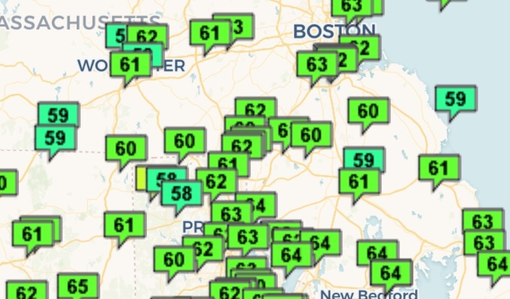
It's 64 but whatevs. How is below normal mild?
-
Oh boy near normal after two solidly below normal days! Kids get in the car we're going to the beach.
-
As Joe Namath said….struggaaliingg
-
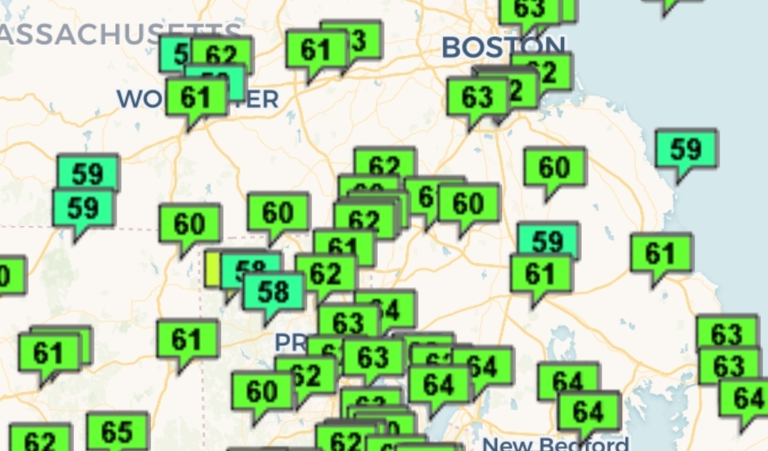
63 for Logan. A bit cooler in the burbs.
-

July 2025 Discussion-OBS - seasonable summer variability
wdrag replied to wdrag's topic in New York City Metro
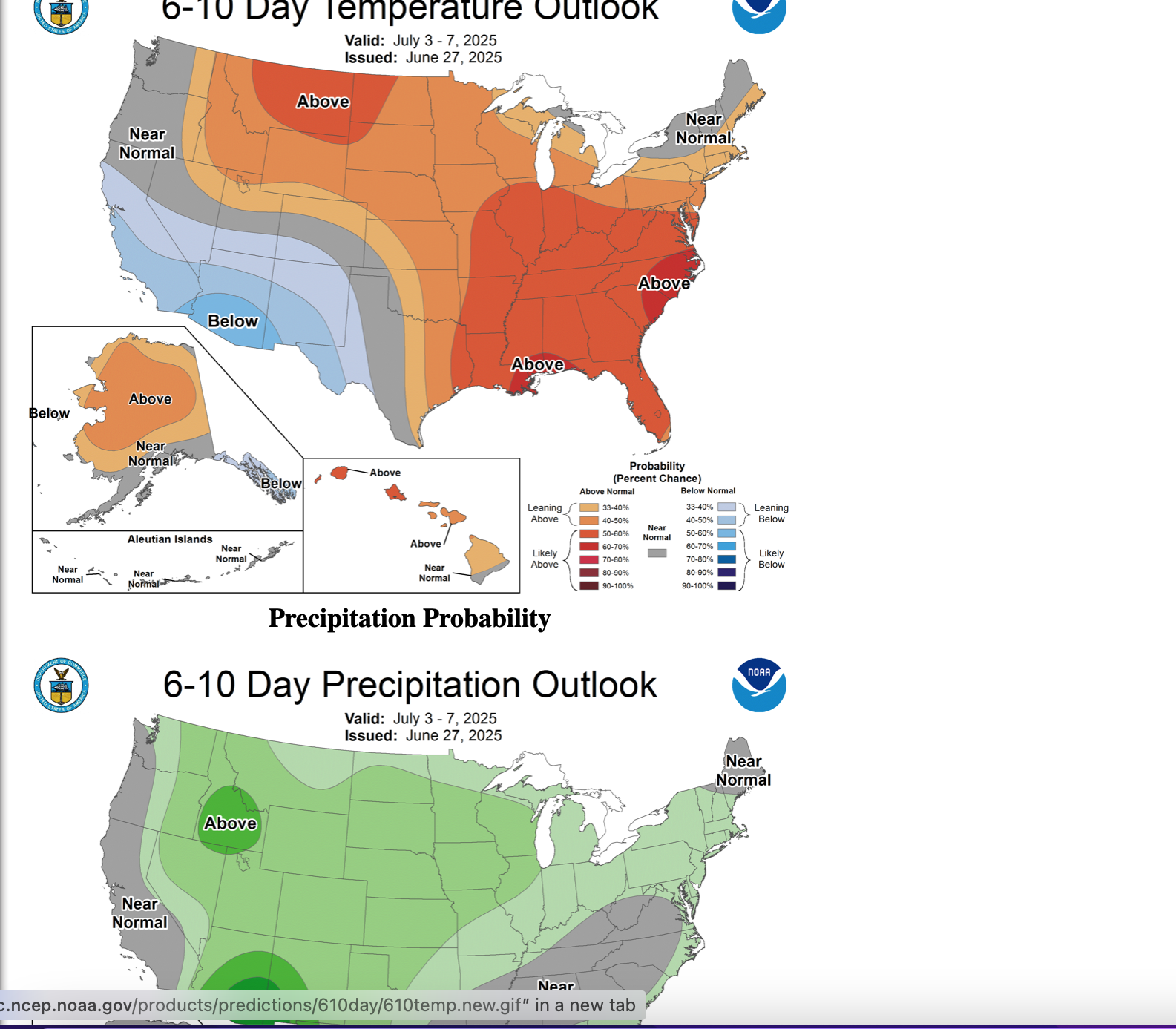
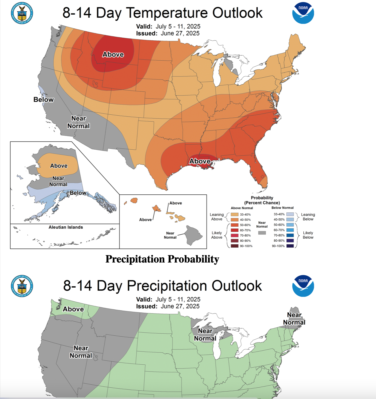
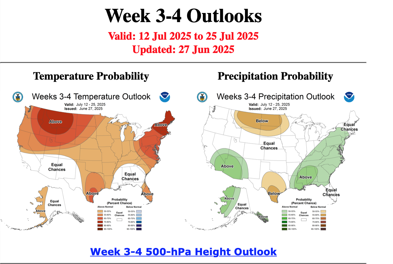
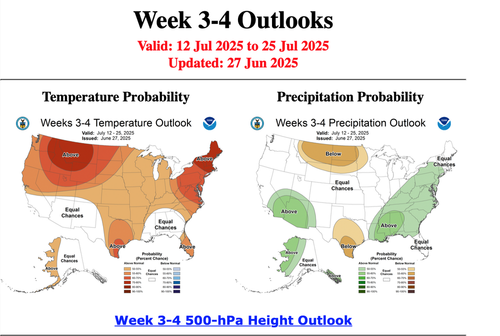
Looks like CPC continues with a warmer than normal July as posted in their 6/19 outlook. Here are some steps in that direction. Their updated monthly should post 6/30. Below from yesterday 6/27 for June periods as listed.

-

July 2025 Obs/Disco ... possible historic month for heat
CoastalWx replied to Typhoon Tip's topic in New England
The 4th looks like the coolest day out of the bunch coming up. Probably near 80 and low dews. Otherwise it’s a summery look. Possibly some 90+ weekend after the 4th. After that we trough again and then as I said yesterday, it looks to retro and open up the door to warmer and more humid weather at the end of the 11-15 day. -
Mild low? Lolz It ain't April. Average low for this time of year is 65.
-
When you start posting dewpoint 2m temps for real temps, it’s just very sad to see.
-
I honestly think they believe what they’re posting too. It’s mind boggling and a little disturbing all in one
-
Mild low near 60. Meh morning but should be better aftn.
-
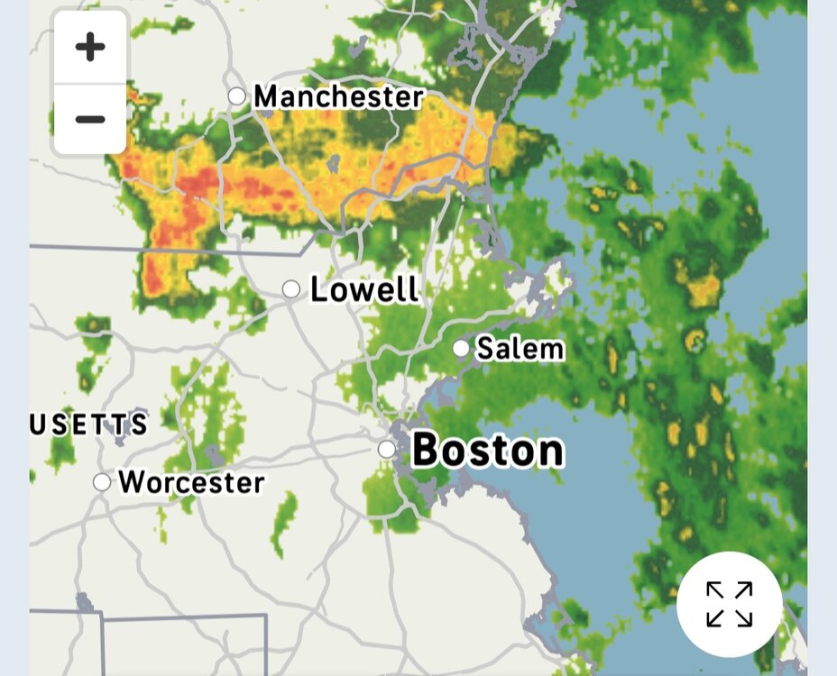
57* and pouring for the past hour. What a beaut of a Saturday.
-
Yeah it’s sad.
-
.13"/60F good down pour, will cut lawn Sunday. Gosh this month flew by to me, just like May WTF
-
Will be near normal today. 2 mild downs in a sea of warmth. ACATT really struggling.
-
Glad I stayed after the top of the 6th. Left at the start of the 7th when up 11-7. Was nice to see them finally be able to get some hits.
-
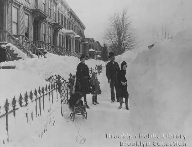
Beautiful collection of photos. There is so much Brooklyn history there going back to the Dutch settlement. The neighborhoods from around Prospect Park back to through your area up to Williamsburg contain some of the most sough-after urban real estate in the United States. I was able to find a great old photo from the Blizzard of 1888. https://www.brownstoner.com/history/blizzard-1888-new-york-brooklyn-snow-storm-history-environmental-subway/ Out in the snow in Cobble Hill, possibly Clinton Street near Amity Street. Photo via Brooklyn Public Library
-
Models go for another strong ridge after the holiday but it's centered SW of us vs directly over and then it retros west. If that holds true then we'll avoid another 100+ stretch.
-
Once we scour out the rain and the 50° temperatures it's shaping up to be a pretty nice day!
- Today
-
Having spent 7 years in the 518 area code, @powderfreakpost is bringing back some nostalgia for me… Granted I held onto my north-Jersey 973 while living there.