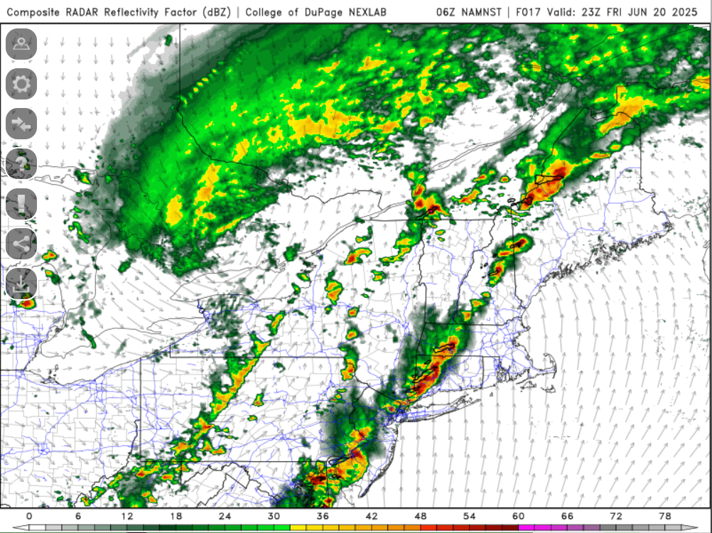
Records:
Highs:
EWR: 98 (2012)
NYC: 98 (1923)
LGA: 98 (2012)
JFK: 94 (2012)
Lows:
EWR: 52 (1956)
NYC: 49 (1914)
LGA: 55 (1959)
JFK: 55 (2005)
Historical:
1682 - A major tornado ripped through southwestern Connecticut, passing through Stratford, Milford, and New Haven, and then into Long Island Sound. (Sandra and TI Richard Sanders - 1987)
1921 - Circle, MT, received 11.5 inches of rain in 24 hours, a record for the state. The town of Circle received a total of 16.79 inches of rain that month to establish a rainfall record for any town in Montana for any month of the year. (The Weather Channel)
1928 - A farmer near Greensburg, KS, looked up into the heart of a tornado. He described its walls as rotating clouds lit with constant flashes of lightning and a strong gassy odor with a screaming, hissing sound . (The Weather Channel)
1964 - A squall line producing large hail swept through central Illinois. A second squall line moved through during the early morning hours of the 21st, and a third one moved through shortly after dawn. The series of hailstorms caused nine million dollars damage. Hailstones as large as grapefruit caused heavy damage to trees, utility lines, crops and buildings. The thunderstorms also produced as much as five inches of rain in an eight hour period. (David Ludlum)
1987 - Thunderstorms prevailed east of the Rockies, producing severe weather in the Central High Plains Region. Thunderstorms spawned four tornadoes in Colorado, and produced wind gusts to 70 mph at Goodland, KS. (The National Weather Summary) (Storm Data)
1988 - Thirty-eight cities in the central U.S. reported record high temperatures for the date. Afternoon highs of 97 degrees at Flint, MI, and 104 degrees at Chicago, IL, equalled records for the month of June. Thunderstorms in North Dakota produced baseball size hail near Kief, and wind gusts to 100 mph near McGregor. (Storm Data) (The National Weather Summary)
1989 - An early morning thunderstorm produced wind gusts to 61 mph at Pierre, SD, and the hot thunderstorm winds raised the temperature from 86 degrees at midnight to 96 degrees by 1 AM, and 104 degrees by 2 AM. Butte, MT, and Yellowstone Park, WY, reported snow that afternoon. (The National Weather Summary) (Storm Data)
1989:A meteorological "hot flash" hit Pierre. Descending air from collapsing thunderstorms caused the temperature in Pierre to warm from 86 degrees at midnight to 96 at one a.m. and to 104 at 2 a.m. Pierre's record high for the date of 105 degrees in 1974.
2001: Large hail driven by strong thunderstorm winds raked Denver International and front-range airports. Wind gusting to 54 mph along with hail as large as 2 inches in diameter punched at least 14 thousand holes and cracks in the flat roofs of several buildings at Denver International Airport. Also, 93 planes and hundreds of cars were damaged. About 100 flights had to be canceled stranding 1500 travelers. The Airport was completely shut down for about 20 minutes. The storm also damaged ground avoidance radar used to track planes on the ground to prevent collisions. Damage was estimated at 10 million dollars not counting the cost to the 93 airliners. The storm moved south and struck Watkins Colorado with hail as large as 2 1/2 inches in diameter and winds gusting to 60 mph.