All Activity
- Past hour
-
This would be one of those “why do I do this hobby again?” Kind of things if this thing now trends back east
-

2/22-23 "There's no way..." Storm Part 2
Weather Will replied to Maestrobjwa's topic in Mid Atlantic
6Z NAMs weaker so far, not as intense. -
Is it me or is it much weaker?
-
I'm going to have to agree with you looks a bit drier.
-

“Cory’s in NYC! Let’s HECS!” Feb. 22-24 Disco
40/70 Benchmark replied to TheSnowman's topic in New England
Looks like the NAM is finally pulling the rug on those doomsday mid atl amounts. -
Going to be less snow on this run
-
HRDPS jumped east and will be a scraper.
-
I'm out to hour 35.
-
“Cory’s in NYC! Let’s HECS!” Feb. 22-24 Disco
40/70 Benchmark replied to TheSnowman's topic in New England
I'd lose it if there were ever a rug-pull right after I finally bought in -
Yeah that's what im saying, the city wasn't prepared. Although the models also had the yips. Ended up with close to 14 inches here. After a prediction of 4 to 8 a day before.
-
Yes.
-
Is the NAM running yet?
-
especially when you get old lol..
-
Never underestimate the groundhogs ability to keep winter going. He might the most reliable forecaster at this point.
-
the nws did a good job on the last storm we had it was the city response that was lacking..
-
Life comes at you fast.
-
If you look at the weather channel forecast and I can consider them one of the most accurate weather sites, they have 1 to 3 for us on Sunday, 8 to 12 Sunday night and another 1 to 3 on Monday
-
If you view the Euro as being somewhat of an outlier, and GFS/NAM as being steroid outliers and weave in the other guidance, it’s a pretty reasonable forecast.
-
And like 12-18 hours ago they where predicting 1-3”
-
they are predicting between 13-18 inches..
-
Clearly against the euro. They had to play catch up. Even a 1” storm could deliver blizzard conditions so its not all about snowfall.
-
So the city can actually prepare right this time. Better to be prepared then to hear the bitching later. Everybody on their toes.!!
-

“Cory’s in NYC! Let’s HECS!” Feb. 22-24 Disco
The 4 Seasons replied to TheSnowman's topic in New England
First one since Jan 2022 in the okx and box CWAs -
i am curious why the nws would issue a blizzard warning kinda early considering the euro run not usually like them to jump the gun so fast..
-
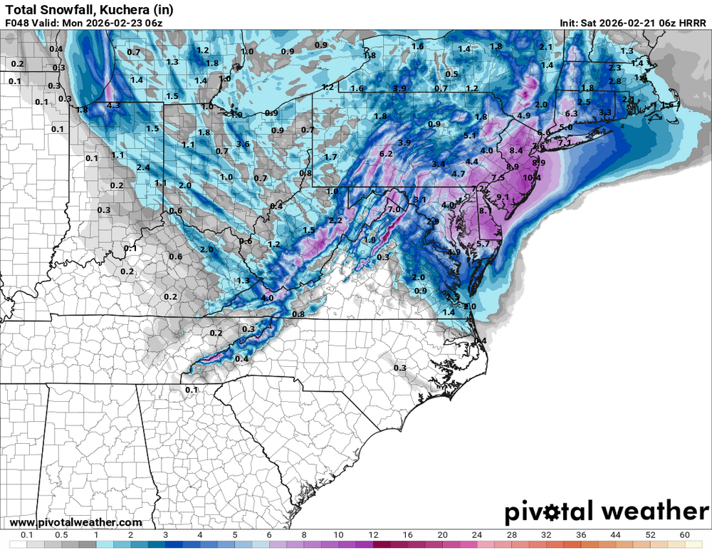
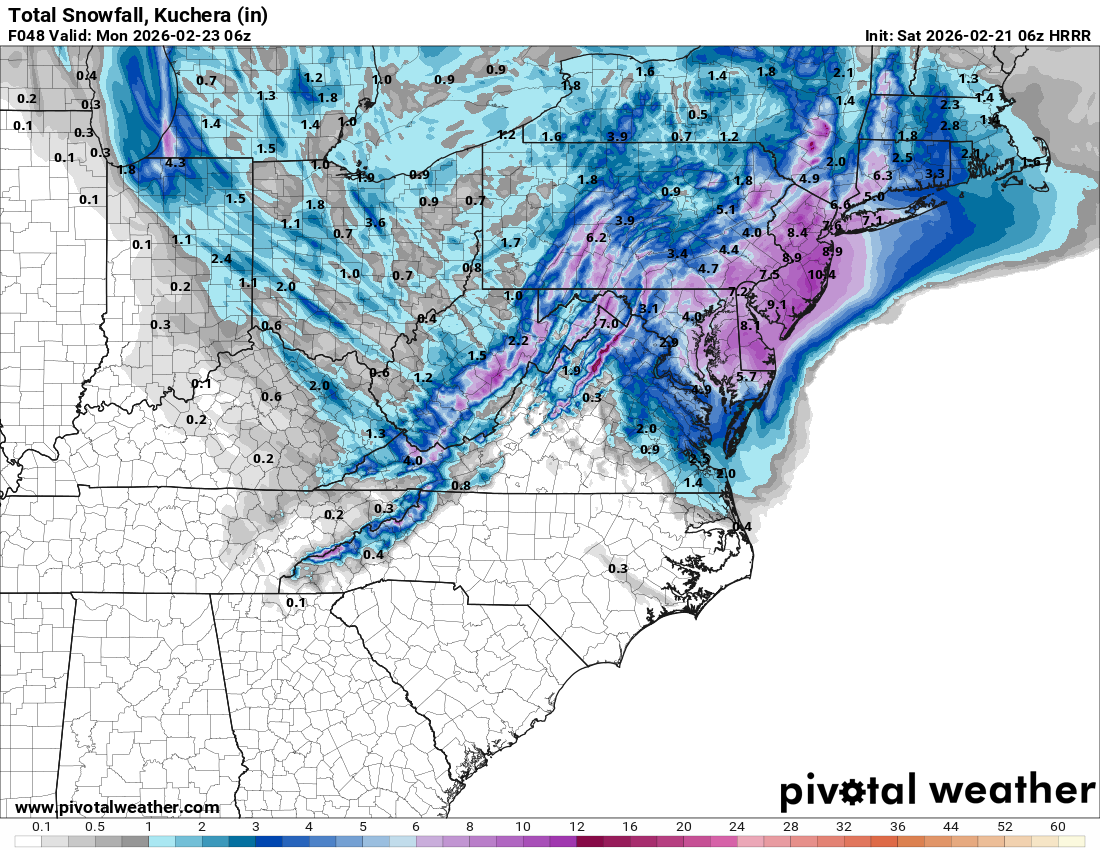
Ugh, just woke up after going down just before the GFS ran. Talk about swings. It's like watching a recorded game seeing your team up big at halftime, only to see it slipping away in the second half. Not jumping off the bandwagon yet, but gotta hope certain aspects of the ECMWF and AIFS aren't gonna become trends. That's is, um, where did the inverted trough go per the EC camp? That and a weaker surface low father offshore? It's like the EC runs of a couple days ago all over again. And I have to tell you, the CMC/GEM wasn't overly inspiring either, with the low farther offshore and much of our area in between the inverted trough band west and mega CCB band over the Eastern Shore. Lastly, the low over the VA Capes giving way to the new forming low off the NJ will need to be monitored. That can really screw with our totals. Remember a few winters back when Central Park had about 11" when they were supposed to get 2-3 feet (while areas east of them did)? That was the result of a similar quick transfer of energy. Not that 11" would be bad! But it was more than half less than what was anticipated. Damn this storm is littered with land mines. BTW 06Z HRRR Kuchera through 06Z Mon. Still snowing..