All Activity
- Past hour
-

2026-2027 Super El Nino
40/70 Benchmark replied to Stormchaserchuck1's topic in Weather Forecasting and Discussion
June 2023 forecast looked pretty different. -
Yeesh. Almost every neighbor on our street is having some sort of party today. If these hold..
-
Was this in any forecast?
-
Central PA Summer 2026 Discussion/Obs Thread
Porsche replied to Voyager's topic in Upstate New York/Pennsylvania
There are much better options now than when I got diagnosed, so hopefully they give you some good options, every case seems to be different and you'll learn to know what works and what doesn't. Take care and good luck! -
Same. Never seen it so bad this early. August sure, but not June
-

Late May/June 2026 Medium/Long Range
Stormchaserchuck1 replied to JenkinsJinkies's topic in Mid Atlantic
I would love a -NAO with Super Nino STJ. Unfortunately, something like 14 Winters in a row have been +NAO (CPC). AO going negative has been easier to achieve. We will also likely have strong +QBO which strengthens the Stratosphere PV. -
Winter 26-27 with averaged - NAO . Also. Appears a weakened or displaced PV
-

2026-2027 Super El Nino
Maestrobjwa replied to Stormchaserchuck1's topic in Weather Forecasting and Discussion
I think 95% of us MidAtl/Northeastern would take that all day--sold! Lol -
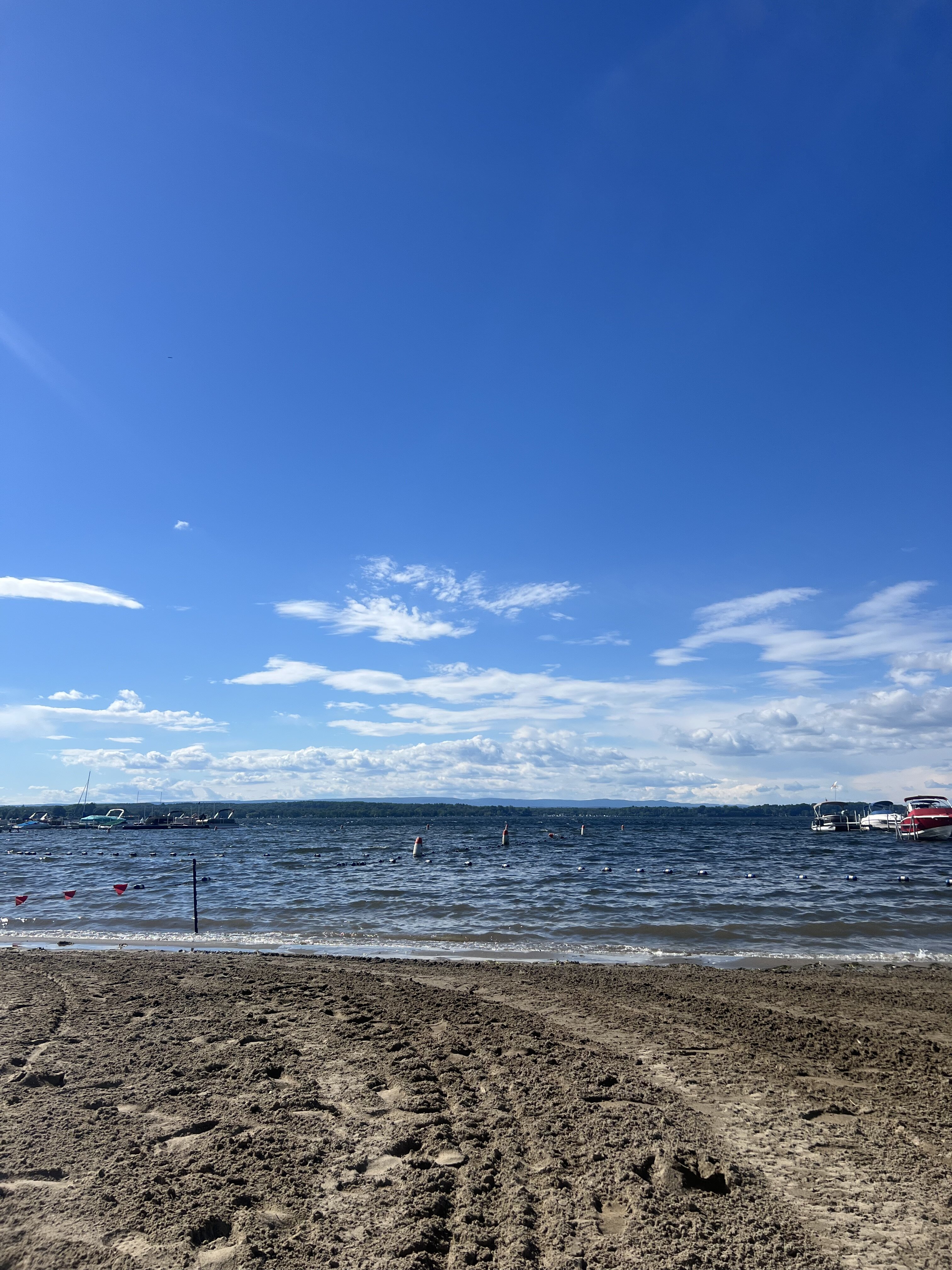
Nice day at the lake beach today in Saratoga. Cleared out about an hour or two ago. Almost time to go to treehouse brewing and grab a beer

-
it has but some act like its been 90 plus for weeks with high dews.. it really hasn't been that bad other that one crappy week
-
another great week coming up!! This Afternoon A chance of showers and thunderstorms, mainly after 5pm. Mostly sunny, with a high near 74. West wind around 14 mph, with gusts as high as 30 mph. Chance of precipitation is 30%. New rainfall amounts of less than a tenth of an inch, except higher amounts possible in thunderstorms. Tonight A chance of showers and thunderstorms, mainly before 7pm. Mostly clear, with a low around 53. West wind 5 to 8 mph becoming calm in the evening. Chance of precipitation is 30%. New precipitation amounts of less than a tenth of an inch, except higher amounts possible in thunderstorms. Sunday A chance of showers and thunderstorms, mainly between 3pm and 5pm. Increasing clouds, with a high near 76. West wind 5 to 8 mph. Chance of precipitation is 30%. New rainfall amounts of less than a tenth of an inch, except higher amounts possible in thunderstorms. Sunday Night A chance of showers and thunderstorms before 7pm. Increasing clouds, with a low around 53. Light west wind. Chance of precipitation is 30%. Monday Showers likely, with thunderstorms also possible after 5pm. Mostly cloudy, with a high near 71. Calm wind becoming southeast around 6 mph in the afternoon. Chance of precipitation is 70%. Monday Night Showers and possibly a thunderstorm before 1am, then showers likely. Low around 55. East wind 3 to 7 mph. Chance of precipitation is 90%. Tuesday A chance of showers before 8am. Mostly sunny, with a high near 77. Northwest wind 5 to 9 mph. Chance of precipitation is 30%. Tuesday Night Mostly clear, with a low around 55. Northwest wind 3 to 5 mph. Wednesday Sunny, with a high near 81. Northwest wind 3 to 5 mph. Wednesday Night Mostly clear, with a low around 57. Calm wind. Thursday A chance of showers. Mostly sunny, with a high near 79. Calm wind becoming southwest around 6 mph in the afternoon. Chance of precipitation is 30%. Thursday Night A chance of showers. Mostly cloudy, with a low around 57. South wind around 5 mph becoming calm in the evening. Chance of precipitation is 40%. Friday Showers likely. Partly sunny, with a high near 77. Calm wind becoming south 5 to 7 mph in the afternoon. Chance of precipitation is 60%. Friday Night Showers likely. Mostly cloudy, with a low around 57. South wind around 5 mph becoming calm in the evening. Chance of precipitation is 60%. Saturday A chance of showers. Partly sunny, with a high near 78.
-
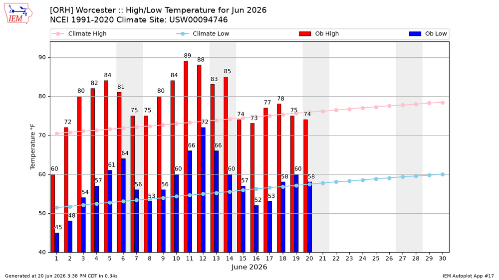
I think ORH only averages something like 3 90+ per year? it has been warm. Not debatable
-
2026-2027 Super El Nino
40/70 Benchmark replied to Stormchaserchuck1's topic in Weather Forecasting and Discussion
Yea, I know it's biased towards stock ENSO, but it makes sense to an extent if the warm pool does slosh east somewhat. -
2026-2027 Super El Nino
40/70 Benchmark replied to Stormchaserchuck1's topic in Weather Forecasting and Discussion
We had more MC influence in 2023 for an east-based pattern despite Modoki like SSTs, but I wonder if we don't end with more Modoki pattern this season despite SSTs looking east-based due to the warm pool being tugged eastward a bit. -
2026-2027 Super El Nino
Stormchaserchuck1 replied to Stormchaserchuck1's topic in Weather Forecasting and Discussion
I think bluewave has pointed out the last major seasonal forecast hit was the JMA in 2013. I do have bad memories of the constant trough over the EC that seasonal models were showing in the Summer/Fall 2023 though. -
2026-2027 Super El Nino
40/70 Benchmark replied to Stormchaserchuck1's topic in Weather Forecasting and Discussion
Anyone notice the JMA 2m temps for next winter? interesting... Looks Modoki. -
Worcester hasn't hit 90 yet this month?
-
Late May/June 2026 Medium/Long Range
Stormchaserchuck1 replied to JenkinsJinkies's topic in Mid Atlantic
It does correlate with following Winter NAO. Right now the Atlantic SST index is slightly negative Here is what you're looking for (default of map is positive phase, with both sides considered) Notice the Atlantic tripole. That's a high correlation for SSTA.- 186 replies
-
- 1
-

-
- we got burned
- rugpull central
- (and 1 more)
-
Late May/June 2026 Medium/Long Range
Stormchaserchuck1 replied to JenkinsJinkies's topic in Mid Atlantic
^Finally getting that El Nino below average temps around the Great Lakes -
Not enough attention is being paid to the spreading cold blob in the North Atlantic. What it means for us, I don't know. But fear not, I have my eye on it.
-
ya its well above but only because of that one crappy week.. it hasn't been constant
-
2026-2027 Super El Nino
Stormchaserchuck1 replied to Stormchaserchuck1's topic in Weather Forecasting and Discussion
Might be another -AO vs +NAO type of scenario, but it's still early. Stronger El Nino going forward might disrupt the consistency over the Arctic, which is imo Solar related. -
2026-2027 Super El Nino
40/70 Benchmark replied to Stormchaserchuck1's topic in Weather Forecasting and Discussion
I would take that. I'm thinking maybe one solid month of -NAO. -
2026-2027 Super El Nino
Stormchaserchuck1 replied to Stormchaserchuck1's topic in Weather Forecasting and Discussion
Should be interesting to see how closely we follow 2015 when the QBO switches. I agree that it's the best ENSO/QBO combo. 23-24 and 72-73 look like good ENSO/PDO matches, although this one will probably be a stronger Nino. And of course 1997 is taking the lead in the subsurface. Next year we will start descending into more of a Solar Min. -
2026-2027 Super El Nino
Stormchaserchuck1 replied to Stormchaserchuck1's topic in Weather Forecasting and Discussion
Since the Solar max in 2024, 3 straight Summers, or in this case early Summer, has had big time cold over the Arctic 60-90N relative to the global warming. I'm thinking that we are pretty close to 2024, 2025 so far.