All Activity
- Past hour
-
The GFS op is definitely an outlier with the ridiculous amount of snow it’s showing in southern NJ, Delmarva, Maryland. No other model shows anything even remotely close
-
Model Mayhem continues. So, at 0Z, the Euro/UK/ICON all have the surface low move ENE from Cape Hatteras with very robust precip fields (with snow on the NW side of those fields) that are just too far SE to do much for people who live on land, while the GFS/CMC/AIFS/Weathernext2 have surface lows that move ENE from about Norfolk, 100+ miles N or Hatteras, with robust precip fields which are close enough to land to put down a lot of snow at the coast and lesser amounts as one goes inland. Which camp do I believe? No idea, but I will say that the fact that the 0Z Euro ensemble mean is well NW of the Op Euro tells me that the Op Euro has a decent chance of being a bit of a SE outlier and that it should move NW and show more snow. If that were the case, that would tip the balance towards a snowier solution, IMO, since right now, the two best models (Euro-AIFS and Euro-Op) are in different camps.
-
Oh yeah the mean went up on the EPS and AIEPS with several big hits in there about 8-10 on the EPS
-

Central PA Winter 25/26 Discussion and Obs
MAG5035 replied to MAG5035's topic in Upstate New York/Pennsylvania
This has actually been the most consistent part of forecasting this the last couple days, the inverted trough/NORLUN feature plus the general lighter snows having to do with the upper level feature dropping through. The last couple model runs have been fairly consistent across the board with delivering a light to moderate snowfall. The 0z suite is solid in C-PA, Euro included, with ensemble support for such things. What is still wildly different is the evolution of the coastal itself. 0z GFS threw down like 30” on a big part of the Delmarva, while the 0z Euro has 1-2” at best there and way offshore with the developing coastal. -
you have some weenievista maps, wxbell isn't out yet
-
Eps is also improved. Nice trends.
-
@psuhoffman the Ai ensembles have snow by tomorrow night lol
-

“Cory’s in NYC! Let’s HECS!” Feb. 22-24 Disco
The 4 Seasons replied to TheSnowman's topic in New England
Euros been out for a while, its worse than 18Z but better than 12Z. still off shore -
We’re not at Mid range. Storm basically starts day after tomorrow
-
So Ukmet, Icon and Euro dont have much of anything. Gfs, Cmc and the AI models at least give us a moderate event.
-

E PA/NJ/DE Winter 2025-26 Obs/Discussion
snowwors2 replied to LVblizzard's topic in Philadelphia Region
…AI euro MUCH improved‼️‼️ -

Feb 22nd/23rd "There's no way..." Storm Thread
Maestrobjwa replied to Maestrobjwa's topic in Mid Atlantic
Forgive me, but...why do you always sound surprised everytine there's model discrepancy in the mid-range? The models are not so good that chaos at this range is some kind of unthinkable thing, lol -

Feb 22nd/23rd "There's no way..." Storm Thread
Solution Man replied to Maestrobjwa's topic in Mid Atlantic
Yep, on its own for now -

“Cory’s in NYC! Let’s HECS!” Feb. 22-24 Disco
RUNNAWAYICEBERG replied to TheSnowman's topic in New England
Euro is bleh. Better than 12z but significantly worse than 18z. -
Euro still gives us a few inches even with the low way overshore.
-
Snowing for 18hrs at 32 or below into the night. Think it would do just fine. But also so I believe any these models are right? No
- Today
-
Because it’s so weak. Snow tv
-
And for you. Good luck getting 5 inches with no rates
-

E PA/NJ/DE Winter 2025-26 Obs/Discussion
MJO812 replied to LVblizzard's topic in Philadelphia Region
Its even worse than 18z after some positives earlier in the run. It might be struggling. -
Feb 22nd/23rd "There's no way..." Storm Thread
Solution Man replied to Maestrobjwa's topic in Mid Atlantic
At 84 it throws a mixed bag into region -
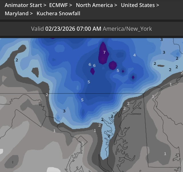
The GFS shows 2 feet in Sailsbury, what could go wrong?
-
NE MD likes this run. But everyone else doesn’t. Wild how different the solutions are on every model now even inside 96hrs.
-
Overall the EC is worse than 18Z but better than 12Z The CMC para is a tick SE of the OP, but improved a lot from its 12Z run.
-
Maybe for you.
-
Euro is absolutely horrific. Non event


