All Activity
- Past hour
-

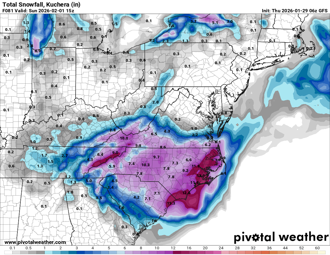
Possible coastal storm centered on Feb 1 2026.
The 4 Seasons replied to Typhoon Tip's topic in New England
yep i knew that 18Z EC/EPS was bullshit. its been happening all winter...watch 6Z come back again. Ok, this time i think it's safe to say she's gone, though for you, you might be scraped. For CT its gone. -
Yes we are.
-

The “I bring the mojo” Jan 30-Feb 1 potential winter storm
Silver Meteor replied to lilj4425's topic in Southeastern States
Wilmington and Myrtle ... what a hoot! -
Off hour runs suck. Never trust them.
-
Off hour runs suck. Never trust them.
-

The “I bring the mojo” Jan 30-Feb 1 potential winter storm
NorthHillsWx replied to lilj4425's topic in Southeastern States
It trended slightly south. It actually benefits you -
The “I bring the mojo” Jan 30-Feb 1 potential winter storm
NorthHillsWx replied to lilj4425's topic in Southeastern States
Not a bad run but a few concerning things. Shaved .1-.2” QPF for a lot of areas and though the snow maps don’t show it well you can see evidence of the dry slot as coastal takes over -
There is not one model now that gives meaningful snow…. I think we can officially declare it dead
-

The “I bring the mojo” Jan 30-Feb 1 potential winter storm
JoshM replied to lilj4425's topic in Southeastern States
lol, your QPF actually went up. So did MBY -

Possible coastal storm centered on Feb 1 2026.
ineedsnow replied to Typhoon Tip's topic in New England
I'll give it until 12z today but could even see changes after that.. if we get that low to the east to change up a bit i think we could move this much further west -

The “I bring the mojo” Jan 30-Feb 1 potential winter storm
lilj4425 replied to lilj4425's topic in Southeastern States
I knew it. Party is over. Probably will be lucky to see flurries now. -

The “I bring the mojo” Jan 30-Feb 1 potential winter storm
timnc910 replied to lilj4425's topic in Southeastern States
Not as good as the runs it has been putting out. The 6z wasn't terrible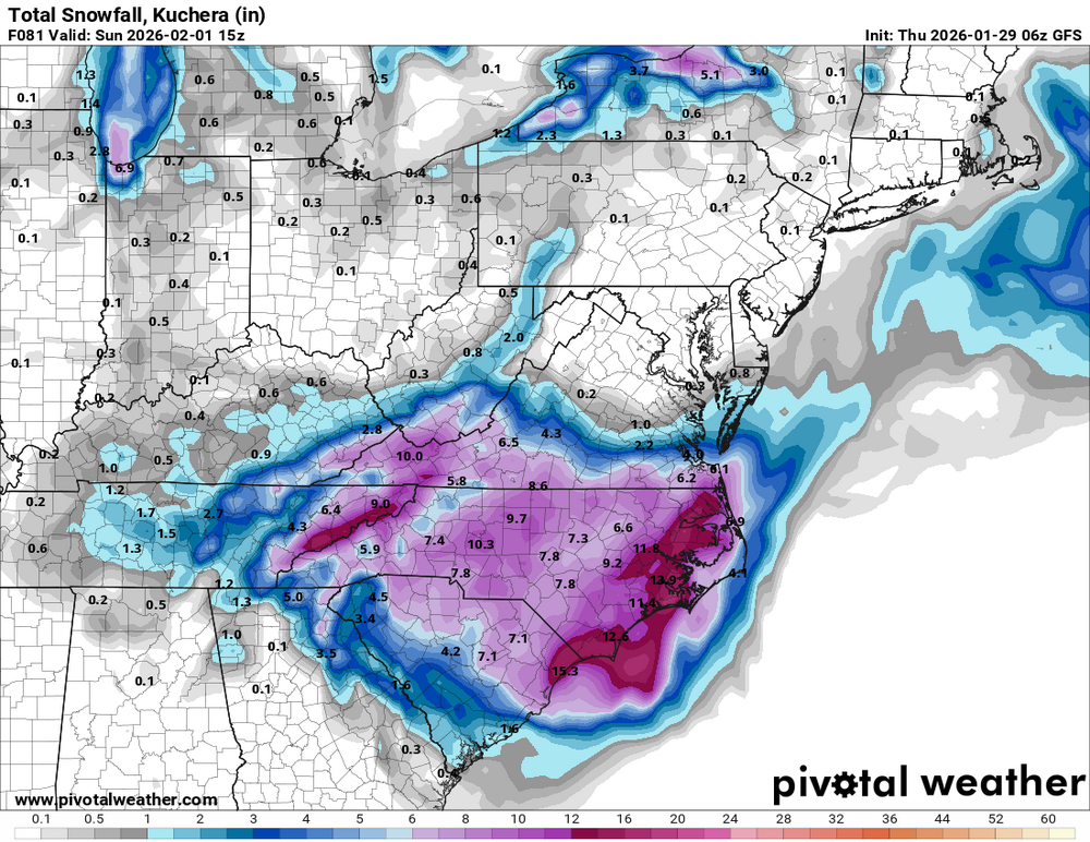
-

Possible coastal storm centered on Feb 1 2026.
CoastalWx replied to Typhoon Tip's topic in New England
Not the best looks overnight. -
The “I bring the mojo” Jan 30-Feb 1 potential winter storm
lilj4425 replied to lilj4425's topic in Southeastern States
It’s due to the transfer occurring. -
The “I bring the mojo” Jan 30-Feb 1 potential winter storm
NorthHillsWx replied to lilj4425's topic in Southeastern States
GFS big hit for coastal areas. Drier pretty much everywhere inland. Also has the dry slot over Raleigh -
The “I bring the mojo” Jan 30-Feb 1 potential winter storm
NorthHillsWx replied to lilj4425's topic in Southeastern States
GFS drier -

February 2026 Medium/ Long Range Discussion: Buckle Up!
CAPE replied to Weather Will's topic in Mid Atlantic
It does look like the next tease will be late next week on the ensembles. -
The “I bring the mojo” Jan 30-Feb 1 potential winter storm
NorthHillsWx replied to lilj4425's topic in Southeastern States
3k has a vicious dry slot Raleigh to coastal plain -
I'd normally post the final snowfall maps here but there is a separate thread for storm totals so i posted them in there, thanks
-

Possible coastal storm centered on Feb 1 2026.
moneypitmike replied to Typhoon Tip's topic in New England
The death of posts overnight said it all. Only 5 of those have any impact up this way. I knew it was a long-shot; this seals the deal. -
low of 2
-
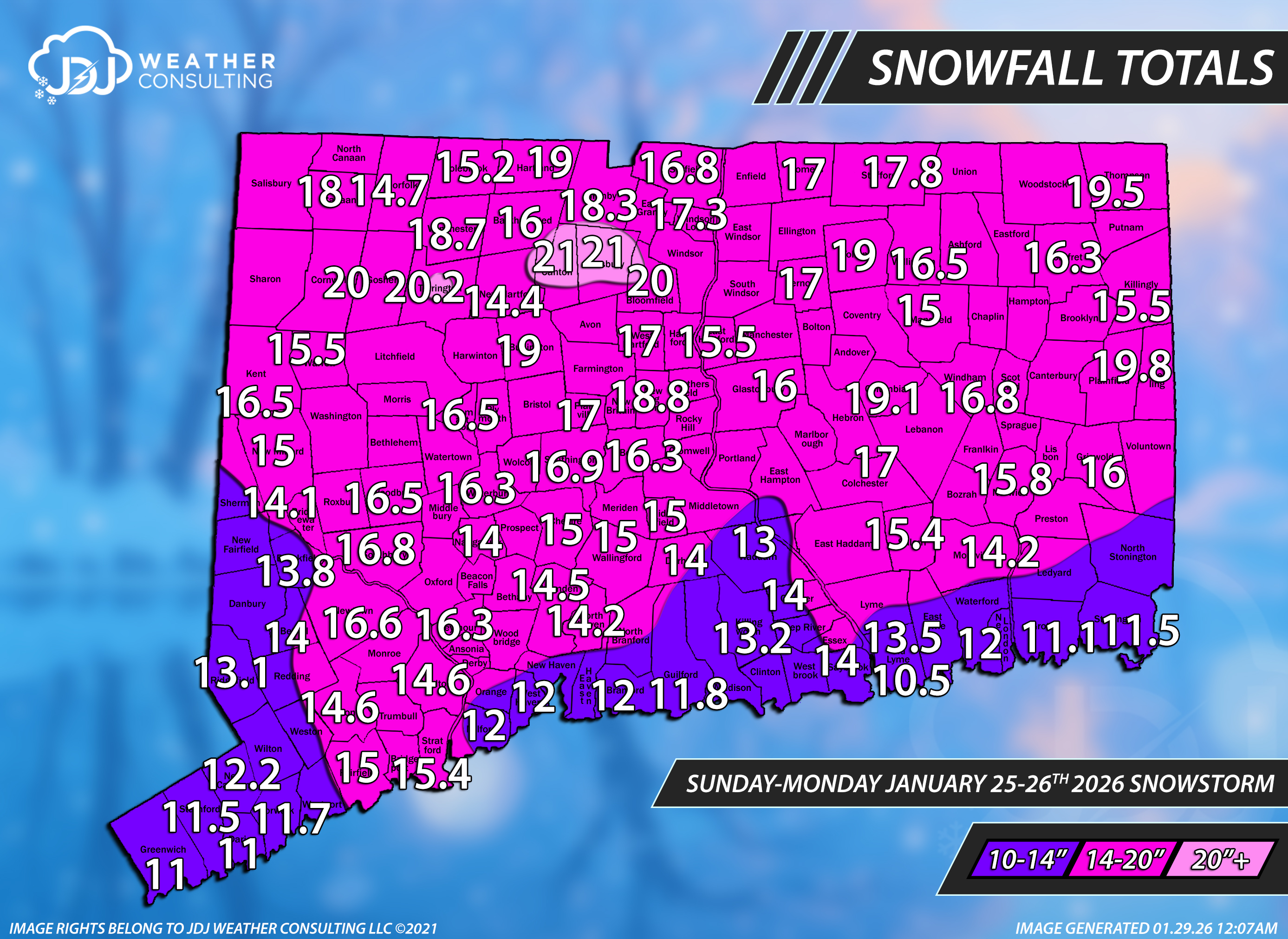
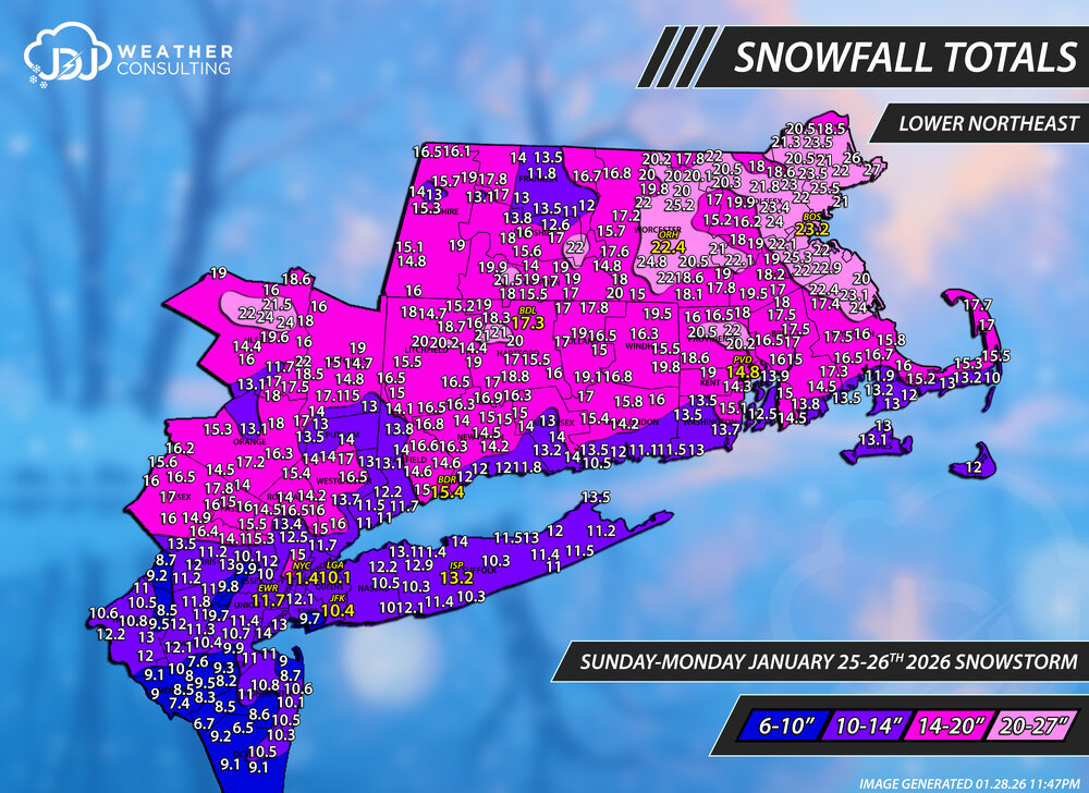
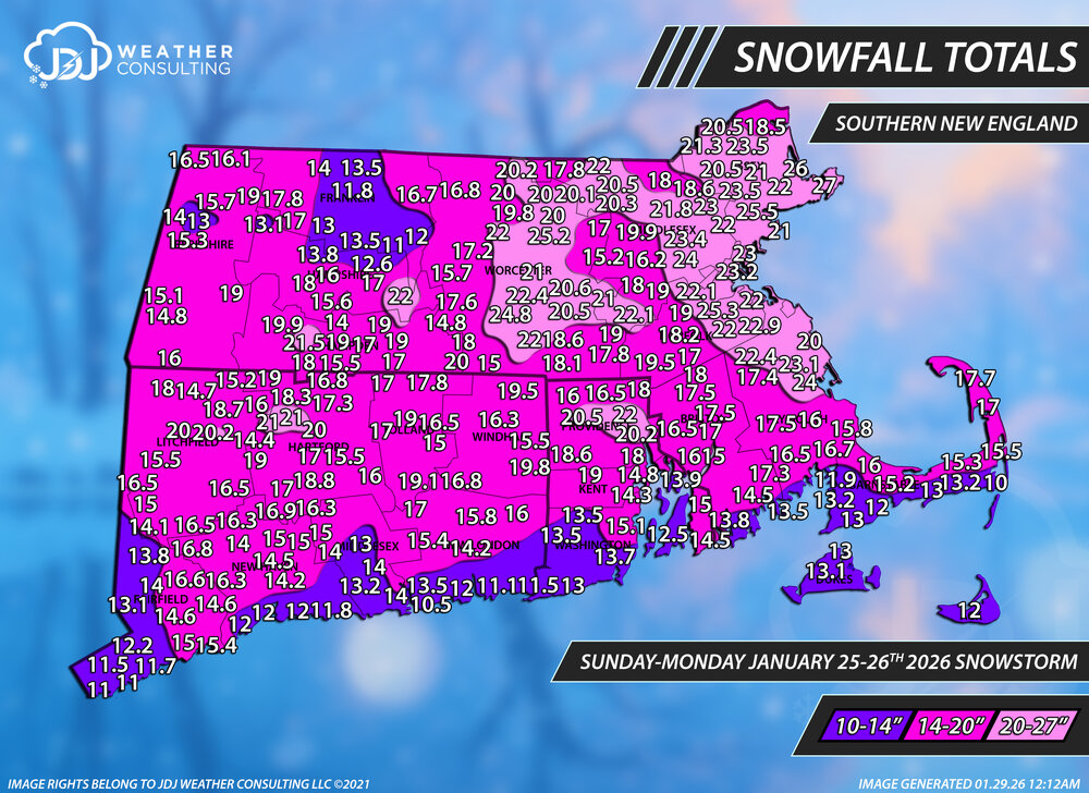
January 25-26th, 2026 Final Storm Totals
The 4 Seasons replied to The 4 Seasons's topic in New England
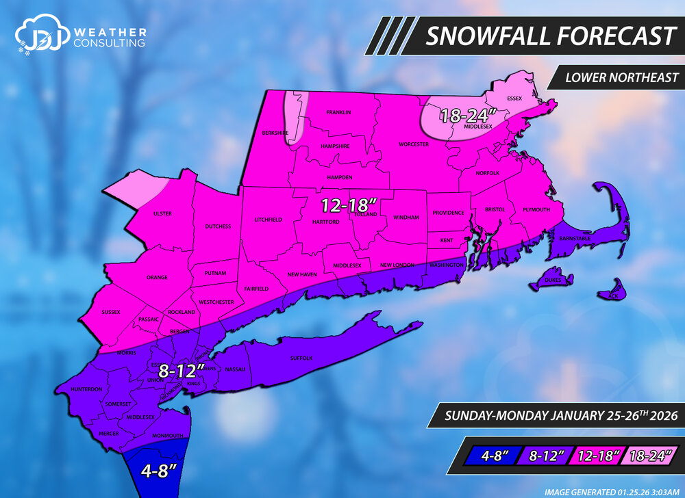
Just finished all the final snowfall maps for this historic snowstorm. I tried to make sure only to include reports that were updated as of late Monday night which was a nightmare (OKX never updated their PNS, the interactive map had tons of old reports, etc). Reports are from here, cocorahs, COOP and official climo sites. Thanks to everyone who messaged me or tagged me in a report. I tried to use most of them if i could fit them in but sometimes they overlap or there is more than 1 for a given town. I ended up changing the ranges to 6-10/10-14/14-20/20-27 to be more fitting with system and so there was less bubbles and holes. These are all up on the site and a full archive link will come later with radar & sfc/upper air maps. https://www.jdjweatherconsulting.com/winter-25-26 The final forecast was mostly good but was a bit too conservative across the board. Most of CT did fall within the 12-18" range with some higher numbers to the north and northeast. SE corner and SW corner also verified in the 8-12 range. Looking back a realistic best call would have been 10-14/14-20 and for SNE 10-14/14-20 and 20-30 or 20+ northeast. Snowfall Totals Final Forecast
-
The “I bring the mojo” Jan 30-Feb 1 potential winter storm
NorthHillsWx replied to lilj4425's topic in Southeastern States
It’s been showing up to varying degrees on different runs across most modeling. If you’re between Greensboro and Greenville that is this storms *potential* fail mode -
The “I bring the mojo” Jan 30-Feb 1 potential winter storm
NorthHillsWx replied to lilj4425's topic in Southeastern States
Yep that is my concern. It is why I posted. It’s damned close to triangle areas and would be an absolute kick in the nads to get 1” with 8”+ on either side -
The “I bring the mojo” Jan 30-Feb 1 potential winter storm
Silver Meteor replied to lilj4425's topic in Southeastern States
This is not the first time I've seen that modeled gap between Raleigh and the Coast. Greenville less snow than anyone? What the hell is going on!