All Activity
- Past hour
-
Nice soaking rain at times today afterall. Finished with .31 here
-

October Comes Early: Late September Multi-Hazard Hybrid Storm
DirtySnowDen replied to WxWatcher007's topic in New England
I’d like this thing to go OTS, but considering the time frame, I’m expecting something of a “landfall” in RI, the high pressure to the north is going to be the determining factor and how it splits. Another smaller, yet important factor, is going to be how strong the Low deepens upon their “dance.” -

October Comes Early: Late September Multi-Hazard Hybrid Storm
WinterWolf replied to WxWatcher007's topic in New England
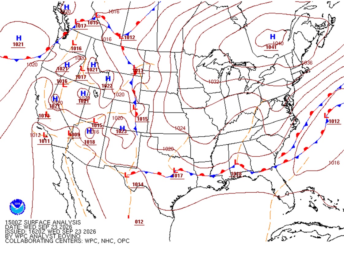
Picking up on the stronger high pressure…? And we are getting closer in now, maybe it’s getting a clue? And yes…that 1041 high is very impressive, have we ever/how often have we seen that in September while a system will be climbing the coast? -

2026 Atlantic Hurricane Season
vortex95 replied to Stormchaserchuck1's topic in Tropical Headquarters
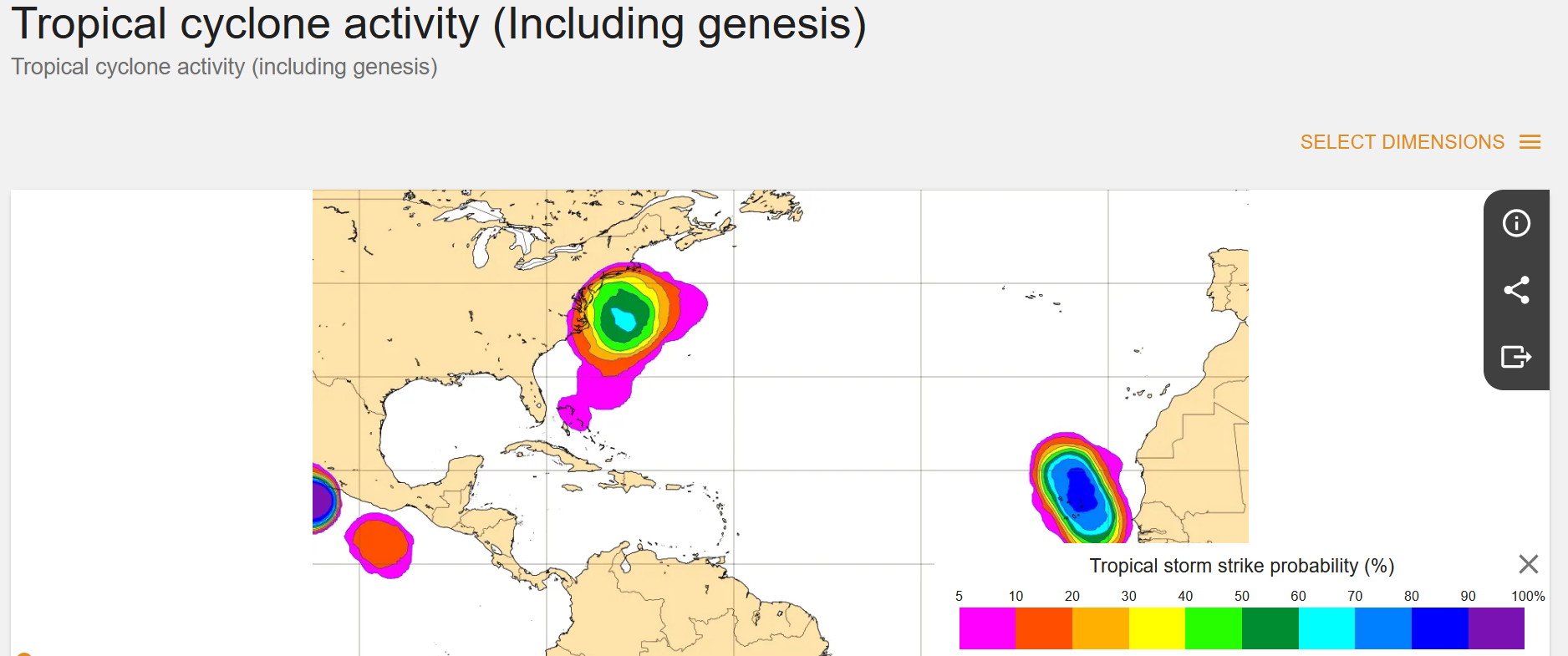
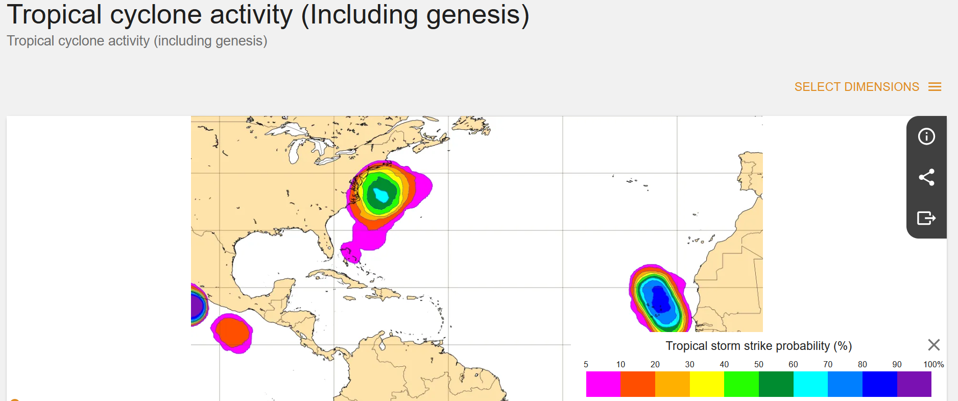
These are non-trivial probabilities for TC formation of the E Coast, and yet nothing in the TWO? Let me put it this way, you can't highlight areas w/ 0/0 chance on the tropical wx outlook (they do do this) and ignore something like this. And beyond the the model probs, from a empirical fcst skill/experience, such a formation is quite possible. So objective end subjective combined, that's how to do it!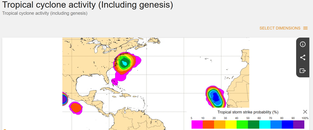
-
October Comes Early: Late September Multi-Hazard Hybrid Storm
DirtySnowDen replied to WxWatcher007's topic in New England
The uncertainty is what’s has my “brain-a-tickin’ -
October Comes Early: Late September Multi-Hazard Hybrid Storm
vortex95 replied to WxWatcher007's topic in New England
Those TC probs are *non-trivial*. Certainly enough to say something in the TWO, so you see what I mean. This is not a far-fetched situation from a model probability standpoint, and lots of decision go/no go as from model probs. As I like to say, you can't have it both ways here! Highlight systems w/ 0/0 percent chance and then ignore something like this? And beyond the the model probs, from a empirical fcst skill/experience, such a formation is quite possible. So objective end subjective combined, that's how to do it! -

Strong Nor'Easter/Hybrid Storm Late September 2026
TriPol replied to Rjay's topic in New York City Metro
Valid 00Z Monday Sep. 28, 8 PM Sunday EDT, the GFS has the center down near the waters south of Long Island / east of New Jersey, while filling rapidly to 999 mb. Compare the evolution: F72: 993 mb, offshore F84: 993 mb, moving west F90: 995 mb, farther west F96: 999 mb, farther west again So this is no longer ambiguous model-map noise. The 00Z GFS explicitly depicts a cyclone that stalls offshore and then tracks back toward the coast while weakening. And the precipitation character changes substantially by F96. The intense compact wraparound band from earlier has weakened considerably, but the circulation is still producing a huge area of rain from NJ/NY through New England. So by Sunday evening the modeled problem has transitioned from a compact, intense coastal cyclone toward a broad, weakening circulation still capable of producing prolonged rainfall. What strikes me most is how much farther the GFS has come compared with the runs we were watching yesterday. The disagreement used to be something like: GFS: northeast and gone. European guidance: trapped, then west. Now the 00Z GFS itself is showing trapped, then west. The exact center, rainfall amounts and timing can absolutely still change. But the synoptic mechanism of a trapped cyclone retrograding toward the Northeast has now survived another GFS cycle, and we're getting into the 3–4 day range. -
Strong Nor'Easter/Hybrid Storm Late September 2026
TriPol replied to Rjay's topic in New York City Metro
Out to 72... the storm is stalled. Just completely stalled off of Long Island. About 150 miles SE. Lots of rain and wind for our areas. -

October Comes Early: Late September Multi-Hazard Hybrid Storm
WxWatcher007 replied to WxWatcher007's topic in New England
FWIW, the GFS is slightly stronger and further west. -

Strong Nor'Easter/Hybrid Storm Late September 2026
GaWx replied to Rjay's topic in New York City Metro
Thanks. But how do you explain a 1000/500 mb thickness max of >576 dm and 700 mb height max both at the center if it is cold core? That almost has to be warm core. -
Strong Nor'Easter/Hybrid Storm Late September 2026
TriPol replied to Rjay's topic in New York City Metro
Holy crap did the GFS absolutely CAVE to the EURO! This is more west than 18z! -
October Comes Early: Late September Multi-Hazard Hybrid Storm
vortex95 replied to WxWatcher007's topic in New England
Prob of TS graphic from ECMWF...great! Did not know about that from WxModels. The ECMWF site itself has it as well.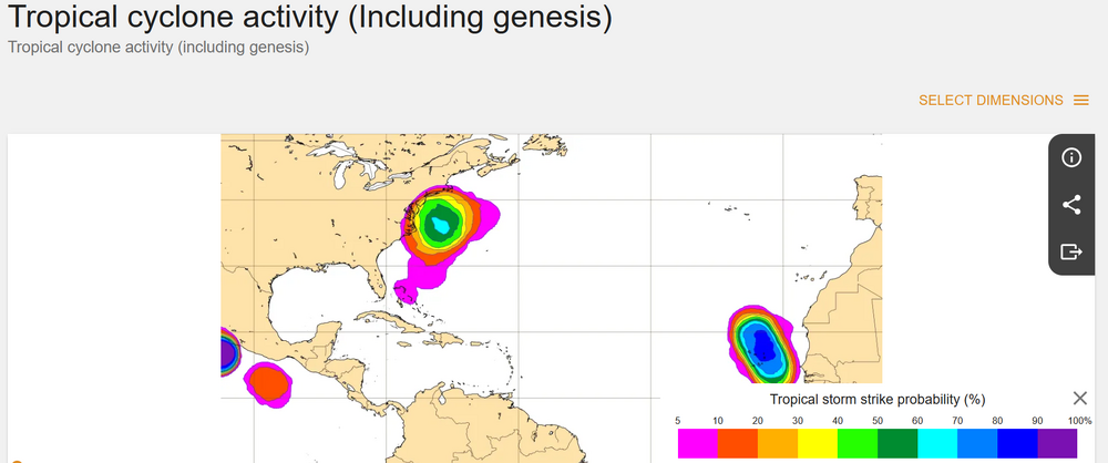
-
Strong Nor'Easter/Hybrid Storm Late September 2026
TriPol replied to Rjay's topic in New York City Metro
0z EURO out to 24... At F24, I do not see an obvious early Bermuda run. The low is still close enough to the Mid-Atlantic coastal zone that the later interaction with the block is very much alive. God if we got this in 3 months from now this forum would be going nuts. -
October Comes Early: Late September Multi-Hazard Hybrid Storm
WxWatcher007 replied to WxWatcher007's topic in New England
1041 is very impressive. -
October Comes Early: Late September Multi-Hazard Hybrid Storm
DirtySnowDen replied to WxWatcher007's topic in New England
The “path of least resistance.” -
October Comes Early: Late September Multi-Hazard Hybrid Storm
vortex95 replied to WxWatcher007's topic in New England
Also, and something @CoastalWxshould pay attention more to, the high in Quebec is 5 mb stronger than fcst. 15z Wed it was 1041 mb, which is an exceptional high pressure value for this area in Sep. 00z it was 1038 mb. So again, don't underestimate the wind potential here. It is just as much about the high to the N than the low to the S! The high holds its ground for the entire event.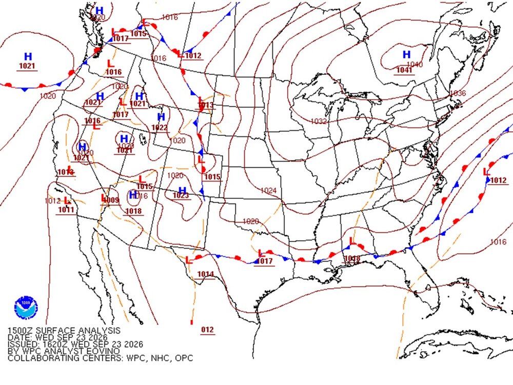
-
October Comes Early: Late September Multi-Hazard Hybrid Storm
DirtySnowDen replied to WxWatcher007's topic in New England
Hide yo’ patio furniture, Hide yo’ wife. Considering there is a lot of disagreement among the models at this timeframe doesn’t bode well, especially for SNE (mainly GON/WOR eastward) - Today
-

October Comes Early: Late September Multi-Hazard Hybrid Storm
NW_of_GYX replied to WxWatcher007's topic in New England
Howdy friends, is my flight home into PWM getting canceled Sunday afternoon or na? -

Strong Nor'Easter/Hybrid Storm Late September 2026
NJwx85 replied to Rjay's topic in New York City Metro
He’s a tool. The reason it weakens is because it becomes vertically stacked and occludes, because it’s cold core. Tropical systems don’t weaken when they become stacked. -
October Comes Early: Late September Multi-Hazard Hybrid Storm
WxWatcher007 replied to WxWatcher007's topic in New England
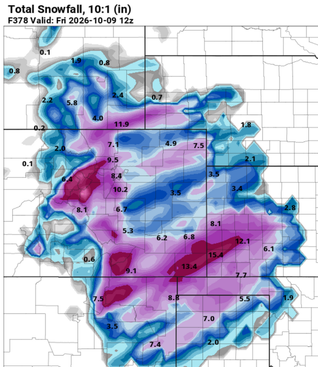
I agree. That's why I think it's important to let the science do the speaking. I'm no met obviously, but I still think it's possible to communicate meteorology in a way that doesn't add all the extra nonsense that pushes people from being effectively informed in the first place. But I think the lack of any mention by the NHC is a pretty significant tell at this stage. Maybe we get some late acknowledgement from them as the system is developing, but I'm not counting on it. Back to the system...even though it's shallow, if anything the GFS and Euro are more aligned on this being warm core than they were a few days ago. We don't get these often, and I'd argue that it's not insignificant if we see this really consolidate as it's crossing the Gulf Stream and organizing on Friday. If this takes longer to pull together it's weaker and more strung out and more mundane...but we don't see this signal often. -
GFS fantasyland maps, how I've missed you
-
October Comes Early: Late September Multi-Hazard Hybrid Storm
WinterWolf replied to WxWatcher007's topic in New England
He loves absolutism….and it’s backfired on him more than once. -
October Comes Early: Late September Multi-Hazard Hybrid Storm
vortex95 replied to WxWatcher007's topic in New England
When dealing w/ outlier events, you need to think outside the box! Odds often are more surprises than usual, so be careful about absolutisms like "this will be nothing like." I brought up Oct 2021 b/c it looped back toward the coast. This storm will likely do the same. That does not mean G113mph on Cape Cod, but such movement for a nor'easter is not typical, so I say again, be careful! Want to know another storm (actually hurricane once reanalyzed) that looped back in and resulted in winds way higher than fcst? Dec 23, 1994. I'm sure a 15 y.o. Scott was taken aback by that in GHG! -
 mexican pharmacy online or mexican pharmacies shipping to usa mexican drugstore http://www.gubanr.com/export.php?url=http://solmedsdirect.com farmacia pharmacy mexico delivery to usa or http://www.orangepi.org/orangepibbsen/home.php?mod=space&uid=7036066 mexican pharmacy prescription savings [url=http://vmus.adu.org.za/vm_search.php?database=vimma&prj_acronym=MammalMAP&db=vimma&URL=http://solmedsdirect.com&Logo=images/vimma_logo.png&Headline=Virtual]order meds from mexico[/url] pharmacies in mexico or [url=http://www.1gmoli.com/home.php?mod=space&uid=1108130]legit mexican pharmacy[/url] mexican pharmacy online ordering
 -
65.7 for a high and 59.8 currently