All Activity
- Past hour
-
 reliable online pharmacy or trusted online pharmacy pharmacy websites http://noexcuselist.com/li/?url=http://quickph.com п»їinternational drug martand https://www.emlynmodels.co.uk/user/qcbiycmzly/ pharmacy websites [url=http://mchsrd.ru/versionPrint/99?model=MSections&url=http://quickph.com/]overseas pharmacy no prescription[/url] overseas pharmacy no prescriptionand [url=https://www.0468wudi.com/home.php?mod=space&uid=268451]no rx needed pharmacy[/url] online pharmacy no prescription
 -

2026-2027 Record-breaking El Nino
40/70 Benchmark replied to Stormchaserchuck1's topic in Weather Forecasting and Discussion
August should be out early next week. -
Terrible
-
2026-2027 Record-breaking El Nino
40/70 Benchmark replied to Stormchaserchuck1's topic in Weather Forecasting and Discussion
August isn't quite out yet...May-July: https://psl.noaa.gov/data/atmoswrit/map/index.html -
Those Detroit storms literally just popped up out of nowhere. Turning into a Flash Food situation even (not necessarily a bad thing with how dry that area's been).
-
@Stebois getting rocked tonight
-
Long range pattern is and has already established itself. It’s clear and evident but he explosive development of storms. And it’s been that way for quite some time. Mild and dry winter here we come!
-
Unbelievable, half of October got punted... Are we really going to get rug pulled instead of the niño kicking in?
-
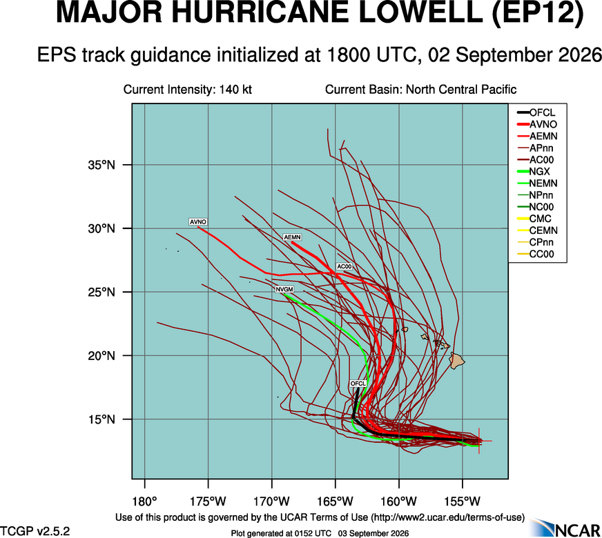
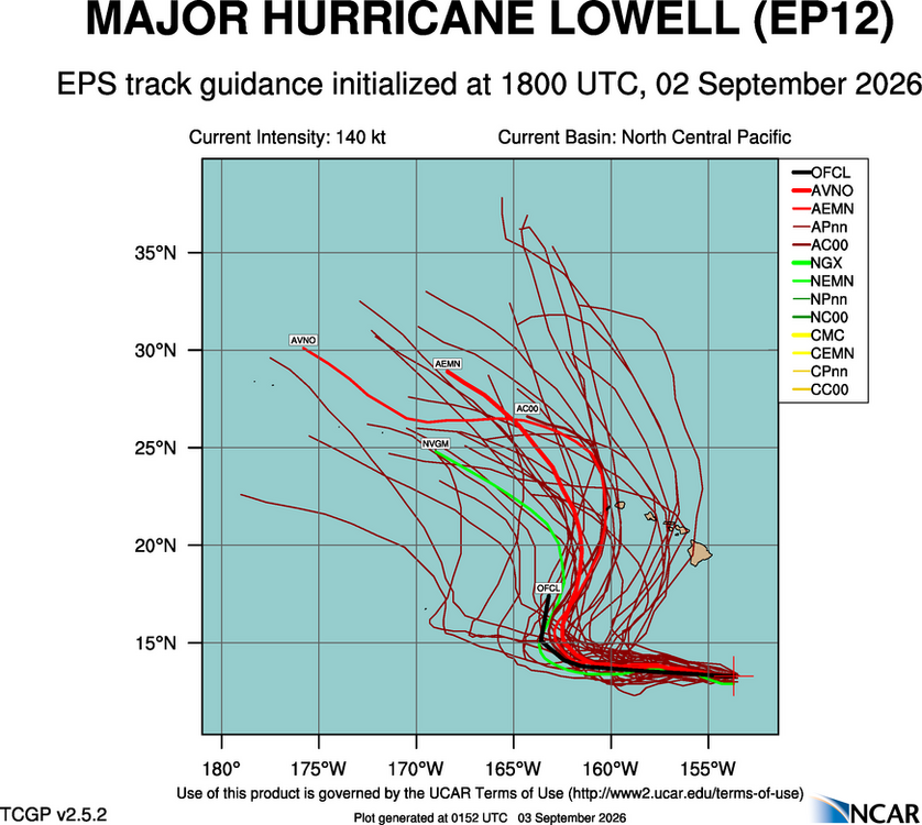
It's complex for Lowell's track. Karina moving into to area N of the islands will likely play a role here as to how strong it may be when it get closer to the trough to the NW, and how it influences the depth and position of the main upper-level trough itself! It is quite a strong 200 mb trough that develops NNW of the islands, but it only digs so far S, and at first it is positively titled and then goes negative, but at that time, it lifting is N rapidly, and then Lowell gets left behind well NW of the islands and starts moving W again. And the ensembles reflect this w/ a recurve path NNE and then it goes back NW. Where will the inflection point be!? Given the intensity of Lowell, 200 mb flow is good to use for general steering flow in this case. This is not like Iwa in 1982 or Iniki in 1992. Those were picked up by strong troughs to the W of islands much farther S, so their tracks were more straight-shooter, acceleration N going ET fairly quickly after passing the islands. Dot's track in 1959 is not the same setup either, and the 1871 estimated Cat 3 hit the eastern side of the Big Island coming in from the, so no real good analogs here when it comes to very close passes or direct hits on HI for hurricanes. Has social media latched on to this threat yet? You know how that goes! @weatherwiz has a great post recently on the Edouard thread about wishcasting, some trying everything and anything to make Edouard to RI. It did start that process. but it ran out of time, and the finer details looking at it evolution in real time that were fascinating in itself were overlooked (not here, elsewhere). Beyond the actual meteorology, I often think about the social and economic factors/impacts. The Lowell threat to HI that is starting to ramp up now about 6 days before any sig impacts, it going to hurt travel/vacation to the state. And say the western part of the state gets hit, the hype/doom will be so intense, ppl are going to think he entire island chain was devastated, and that has huge impacts well down the road for tourism and the like.
-
.thumb.jpg.6a4895b2a43f87359e4e7d04a6fa0d14.jpg)
Central PA Summer 2026 Discussion/Obs Thread
Yardstickgozinya replied to Voyager's topic in Upstate New York/Pennsylvania
short live stream of the lightning from the northern york county, looking north from a slight elevation -
 Tomorrow afternoon/early evening will be our best chance for scattered convection.
 - Today
-
2026-2027 Record-breaking El Nino
40/70 Benchmark replied to Stormchaserchuck1's topic in Weather Forecasting and Discussion
Well, like you said....we need to give it through October. -
2026-2027 Record-breaking El Nino
40/70 Benchmark replied to Stormchaserchuck1's topic in Weather Forecasting and Discussion
Should be in the seasonal mean, but we need to time one during the negative intervals...there should be some. -
 So far it hasn't I agree that the cold season will be super interesting to see if it happens or not. Like I said models showing -200dm for a monthly mean, are they that bad? lol
 -
2026-2027 Record-breaking El Nino
40/70 Benchmark replied to Stormchaserchuck1's topic in Weather Forecasting and Discussion
BTW, if you have seen the EURO and CANSIPS snowfall output, this appears to be what these models do. -
SPC has day 4 yellow highlighted 15% risk out for portions of East Tennessee https://vxtwitter.com/iembot_mrx/status/2095070809425371576?s=46&t=nTdsbQZkQMPkUI3zGjAXJg .
-
Usually that storm track happens in +NAO raindancewx still has to tell me how he gets U of Del precip working on that map lol
-
2026-2027 Record-breaking El Nino
40/70 Benchmark replied to Stormchaserchuck1's topic in Weather Forecasting and Discussion
Sure, but the question you need to ask yourself..."is it already out of the picture completely"...because if the answer is no, then it will show up this season. -
Next year should make up for it with a Nina, assuming the mdr warms back up. But yeah this season was dead on arrival. .
-
2026-2027 Record-breaking El Nino
40/70 Benchmark replied to Stormchaserchuck1's topic in Weather Forecasting and Discussion
-
I'm not actually taking for granted that the El Nino will actually do anything to the N. Pacific pattern. Models have -120 to 200dm on monthly means... they usually don't bust that bad... but we are in a "time" where the N. Pacific low is trending more and more out of the picture completely. Just the way it's going.
-
2026-2027 Record-breaking El Nino
40/70 Benchmark replied to Stormchaserchuck1's topic in Weather Forecasting and Discussion
Agree. I wonder if a neutralish PDO with an El Niño of this magnitude doesn't shift the STJ inward and upward relative to climo for intense El Niño. -
I don't think the SE, US will be below average temps like a lot of historical analogs suggest
-
2026-2027 Record-breaking El Nino
40/70 Benchmark replied to Stormchaserchuck1's topic in Weather Forecasting and Discussion
Yea, someone in the New England forum was trying to tell me were going to have a -PNA this winter...I was like, find a super El Niño that pulled that off. -AO/+PNA means you can essentially eliminate the bottom dwelling seasons....even 1972 didn't. Now, maybe it will be bootleg, etc...but the season will average +PNA in the DJFM mean. -
https://quickph.com/# online pharmacy without prescription