NorthArlington101
-
Posts
10,979 -
Joined
-
Last visited
Content Type
Profiles
Blogs
Forums
American Weather
Media Demo
Store
Gallery
Everything posted by NorthArlington101
-

February 11-12; 12-13: Are they real??
NorthArlington101 replied to stormtracker's topic in Mid Atlantic
GFS slower through 51, not bothering me yet -
February 11-12; 12-13: Are they real??
NorthArlington101 replied to stormtracker's topic in Mid Atlantic
The uncertainties about temperatures and rates do knock this down - they are predicting what sticks. Big items on my list today are seeing if the can get temps down and/or get the heaviest after dark. Don’t want to burn the best stuff before 6pm. -
February 11-12; 12-13: Are they real??
NorthArlington101 replied to stormtracker's topic in Mid Atlantic
-
February 11-12; 12-13: Are they real??
NorthArlington101 replied to stormtracker's topic in Mid Atlantic
No real directional shift, just wetter. if it goes this way it’s pretty funny the ens wouldve nailed it 8 days out, lost it, then found it again
-
February 11-12; 12-13: Are they real??
NorthArlington101 replied to stormtracker's topic in Mid Atlantic
00z 18z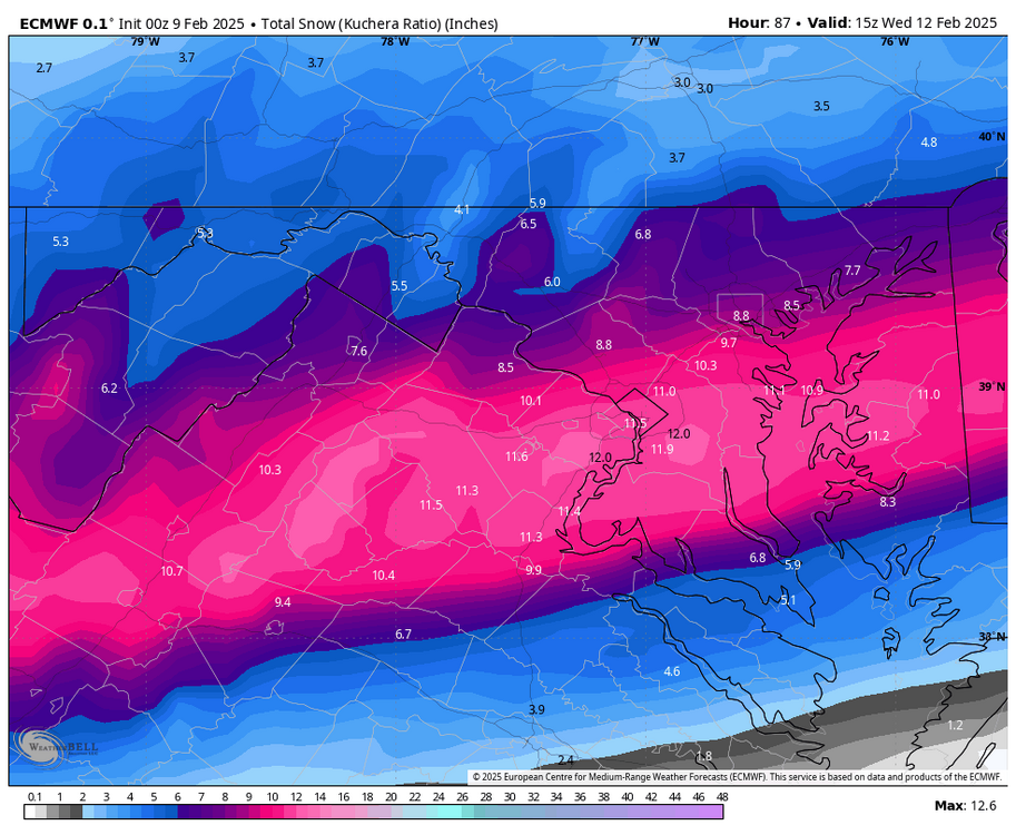
-
February 11-12; 12-13: Are they real??
NorthArlington101 replied to stormtracker's topic in Mid Atlantic
I don’t see that at all between 18z and 00z tbh The southern end hasn’t moved… maybe that’s what I’m really talking about -
February 11-12; 12-13: Are they real??
NorthArlington101 replied to stormtracker's topic in Mid Atlantic
It’s astounding what a couple runs does to your expectations. Now I’m gonna be salty if I only get 3” -
February 11-12; 12-13: Are they real??
NorthArlington101 replied to stormtracker's topic in Mid Atlantic
No real directional trend, just wetter
-
February 11-12; 12-13: Are they real??
NorthArlington101 replied to stormtracker's topic in Mid Atlantic
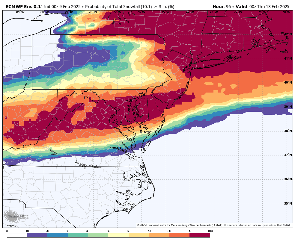
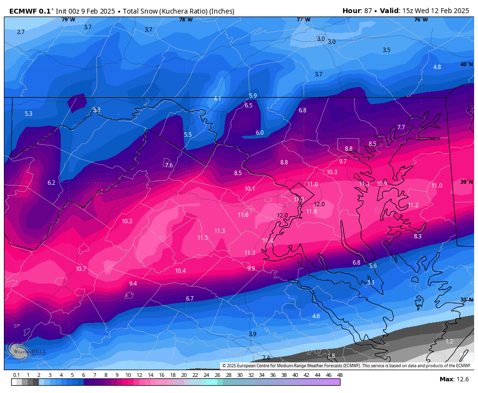
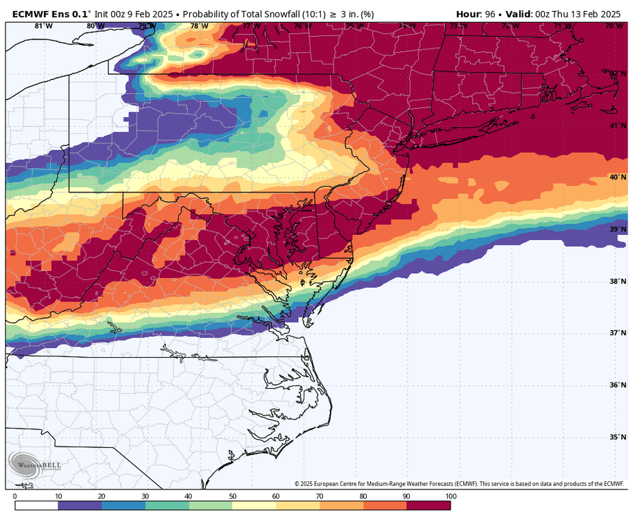
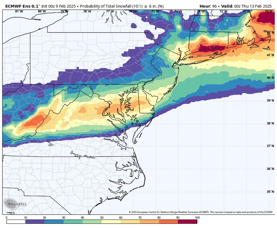
10”+ DC -
February 11-12; 12-13: Are they real??
NorthArlington101 replied to stormtracker's topic in Mid Atlantic
EURO looks good -
February 11-12; 12-13: Are they real??
NorthArlington101 replied to stormtracker's topic in Mid Atlantic
NWS forecast thru Tuesday @ 7pm
-
February 11-12; 12-13: Are they real??
NorthArlington101 replied to stormtracker's topic in Mid Atlantic
CMC is a very different look than the GFS but a net improvement from 12z -
February 11-12; 12-13: Are they real??
NorthArlington101 replied to stormtracker's topic in Mid Atlantic
I think we forgot to share the 18z EPS? Need to rectify that mistake... this is gorgeous -
February 11-12; 12-13: Are they real??
NorthArlington101 replied to stormtracker's topic in Mid Atlantic
snowmap looks like the 06z Thursday run lol -
February 11-12; 12-13: Are they real??
NorthArlington101 replied to stormtracker's topic in Mid Atlantic
It snows at DCA almost every hour from 66 to 96. Would snow for more hours then we get in many a winter. -
February 11-12; 12-13: Are they real??
NorthArlington101 replied to stormtracker's topic in Mid Atlantic
I'm still unsure looking at this side-by-side if this was really a jog "north" or just wetter. I'm okay with either trend where we stand for now. -
February 11-12; 12-13: Are they real??
NorthArlington101 replied to stormtracker's topic in Mid Atlantic
If it pans out, I demand Rotunda snow photos. Nobody has provided this subforum that service since I graduated in 2022. Best snowstorm scenery in the U.S.. -
February 11-12; 12-13: Are they real??
NorthArlington101 replied to stormtracker's topic in Mid Atlantic
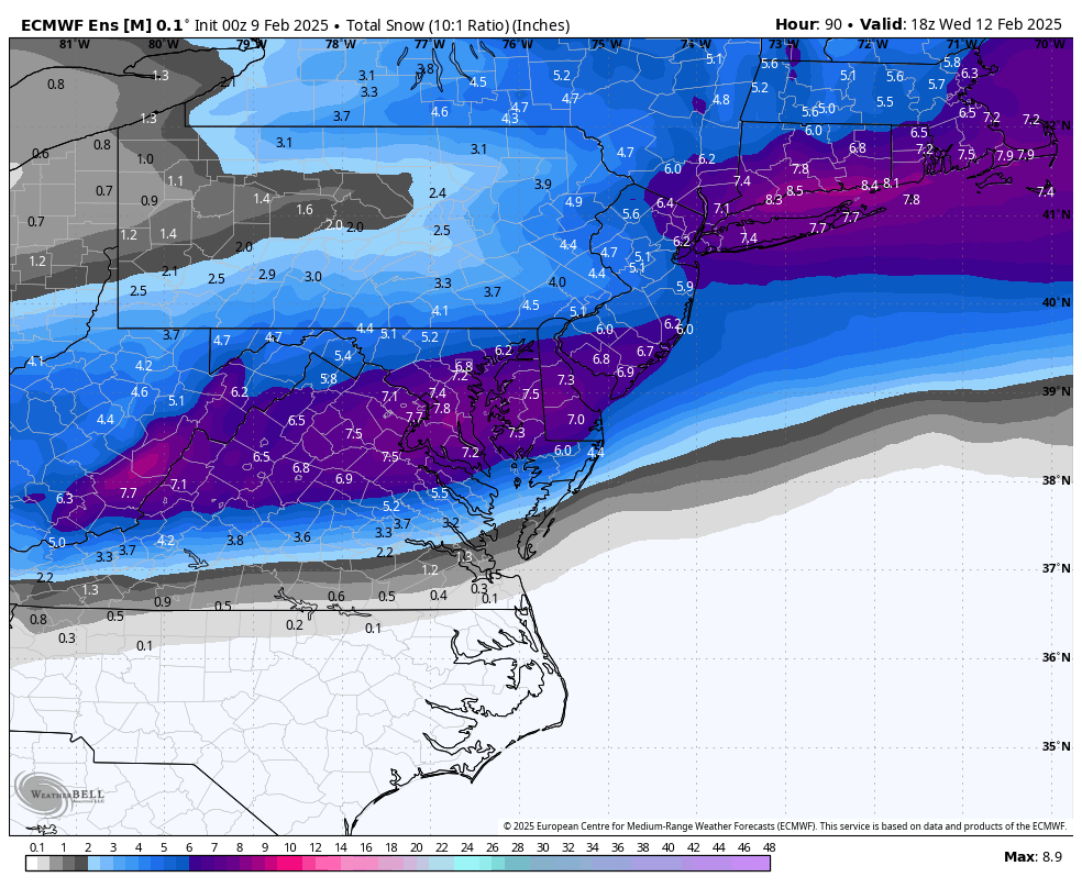
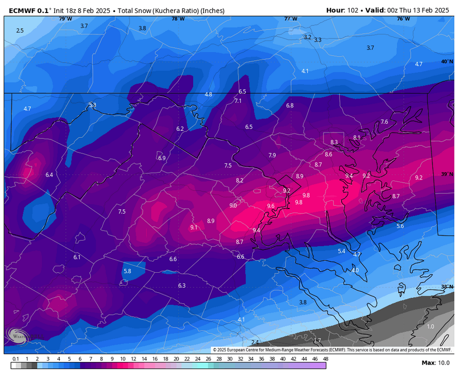
1000%. though, that 16.3" max isn't that far south... -
February 11-12; 12-13: Are they real??
NorthArlington101 replied to stormtracker's topic in Mid Atlantic
BOOM -
February 11-12; 12-13: Are they real??
NorthArlington101 replied to stormtracker's topic in Mid Atlantic
there is - and wetter/norther again. Nothing MAJOR -
February 11-12; 12-13: Are they real??
NorthArlington101 replied to stormtracker's topic in Mid Atlantic
Nice storm Tuesday late morning-early night - seeing if there is a second wave Wednesday morning. -
February 11-12; 12-13: Are they real??
NorthArlington101 replied to stormtracker's topic in Mid Atlantic
can't really tell if it's more north or just wetter... good either way -
February 11-12; 12-13: Are they real??
NorthArlington101 replied to stormtracker's topic in Mid Atlantic
looks pretty similar at hr60 -
February 11-12; 12-13: Are they real??
NorthArlington101 replied to stormtracker's topic in Mid Atlantic
RGEM is a weird evolution - there is an end-of-run flip to sleet/FRZA here too -
February 11-12; 12-13: Are they real??
NorthArlington101 replied to stormtracker's topic in Mid Atlantic
ends up worse once you get north of DC, unfortunately