

TSSN+
-
Posts
4,731 -
Joined
-
Last visited
Content Type
Profiles
Blogs
Forums
American Weather
Media Demo
Store
Gallery
Everything posted by TSSN+
-
When they go low that’s when we score
-
The hell you talking about
-
Nam is a smoke show, absolutely beautiful
-
Nam is going annular
-
My guess will be out after 3pm there
-
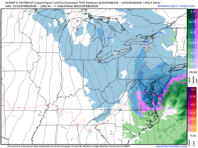
Well then ...WINTER STORM WARNING IN EFFECT FROM 5 AM SUNDAY TO 1 PM EST MONDAY... * WHAT...Heavy snow likely. Total snow accumulations between 6 and 12 inches possible. Winds could gust as high as 40 mph Sunday night and Monday. * WHERE...A portion of central Pennsylvania. * WHEN...From 5 AM Sunday to 1 PM EST Monday. * IMPACTS...The strong winds and weight of snow on tree limbs may down power lines and could cause sporadic power outages. Travel could be very difficult to impossible. The hazardous conditions could impact the Monday morning commute. * ADDITIONAL DETAILS...Uncertainty remains for where the heaviest snow bands will occur. Snow totals could be higher depending on these localized bands. Snowfall at times could exceed 1 inch per hour rates.
-
Got em right where we want em
-
Keep it coming!
-
Ya that’ll change later now the euro just went boom
-
More like the jester on this storm. Finally catches on in the last 24hrs
-
Yes
-
Fold
-

The February 22-23 Late Season Miracle: JV Disco/Banter Thread
TSSN+ replied to bncho's topic in Mid Atlantic
Been on a liquid diet for 24hrs. Finally got upgraded to real food lol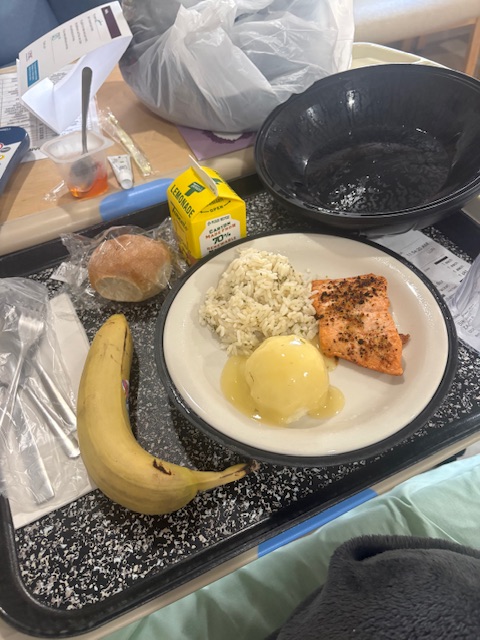
-
Hey if we get lucky, let it snow. If not I will carry on.
-
We all know the super unhinged haha
-
Track them yes. But I’m not crying over a storm misses. I don’t care if I get 1” or 15”. It’s whatever
-
Since when have I got upset that it’s not snowing? I haven’t. I say who cares. I don’t.
-
People get too worked up over this stuff. Over the last 2 years I learned to just let it go. Do I want snow? Sure. Am I going to freak out over it not? No
-
The February 22-23 Late Season Miracle: JV Disco/Banter Thread
TSSN+ replied to bncho's topic in Mid Atlantic
Not a lot to do when laying in a hospital bed haha -
The February 22-23 Late Season Miracle: JV Disco/Banter Thread
TSSN+ replied to bncho's topic in Mid Atlantic
I didn’t even see this thread. Thanks for all the well wishes. I am feeling better mostly. Had a high fever but that’s gone now, still have some pain in my abdomen but it’s much less than it was. Been on antibiotics, Tylenol,and pain meds. Waiting for a doctor to come in to discuss game plan. I wanna go home lol. -
In the hospital still but feeling much better than yesterday. Thank you
-
I’d say it’s about time we got positive game time improvements from a system. Hopefully it continues into tonight and we all looking at a massive snow storm.
-
They do now
-
URGENT - WINTER WEATHER MESSAGE National Weather Service Baltimore MD/Washington DC 812 AM EST Sat Feb 21 2026 DCZ001-MDZ013-016-504-VAZ053-054-057-501-506-526-527-212115- /O.EXA.KLWX.WS.A.0003.260222T2000Z-260223T1500Z/ District of Columbia-Prince Georges-Charles-Central and Southeast Montgomery-Fairfax-Arlington/Falls Church/Alexandria-King George- Northern Fauquier-Eastern Loudoun-Northwest Prince William- Central and Southeast Prince William/Manassas/Manassas Park- 812 AM EST Sat Feb 21 2026 ...WINTER STORM WATCH IN EFFECT FROM SUNDAY AFTERNOON THROUGH MONDAY MORNING... * WHAT...Heavy snow possible. Total snow accumulations of 5 or more inches possible. Winds could gust as high as 35 mph. * WHERE...DC and portions of central and southern Maryland, and central and northern Virginia. * WHEN...From Sunday afternoon through Monday morning. * IMPACTS...Plan on slippery road conditions. The hazardous conditions could impact the Monday morning commute. PRECAUTIONARY/PREPAREDNESS ACTIONS... Monitor the latest forecasts for updates on this situation.
-
It’s about to smoke


