TSSN+
-
Posts
4,772 -
Joined
-
Last visited
Content Type
Profiles
Blogs
Forums
American Weather
Media Demo
Store
Gallery
Everything posted by TSSN+
-

Outta gas and Outta Time: Early March Winter Storm finale
TSSN+ replied to Ji's topic in Mid Atlantic
Put us out of our misery -
Models can’t even get rain right 6hrs out. Had it dry up jere today and it’s been raining for over an hour.
-
Outta gas and Outta Time: Early March Winter Storm finale
TSSN+ replied to Ji's topic in Mid Atlantic
Ya it’s raining when most models said no precip. Def not snow though lol -
Outta gas and Outta Time: Early March Winter Storm finale
TSSN+ replied to Ji's topic in Mid Atlantic
Perfect lol -
Outta gas and Outta Time: Early March Winter Storm finale
TSSN+ replied to Ji's topic in Mid Atlantic
Ok now out far enough. Ya that’s noting going to get it done. Needs to beef up -
Outta gas and Outta Time: Early March Winter Storm finale
TSSN+ replied to Ji's topic in Mid Atlantic
More than the last? -
Outta gas and Outta Time: Early March Winter Storm finale
TSSN+ replied to Ji's topic in Mid Atlantic
Anyone got euro op yet. I’m out to 84 on my site but it’s always behind -
Outta gas and Outta Time: Early March Winter Storm finale
TSSN+ replied to Ji's topic in Mid Atlantic
I mean it was wrong lol. Just cause a model shows a low over the Midwest an it ends up in the Ohio valley doesn’t mean it was right. Ya all the models show outputs that maybe somewhat close but when we are looking at our area what happens matters. -
Outta gas and Outta Time: Early March Winter Storm finale
TSSN+ replied to Ji's topic in Mid Atlantic
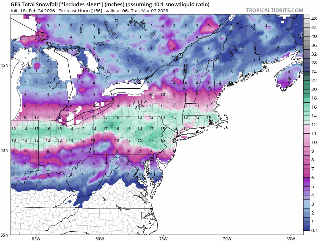
Meh I mean it showed us getting 20”+ for this past weekend for multiple runs at this range so -
Outta gas and Outta Time: Early March Winter Storm finale
TSSN+ replied to Ji's topic in Mid Atlantic
Live on for another 6hrs -
Outta gas and Outta Time: Early March Winter Storm finale
TSSN+ replied to Ji's topic in Mid Atlantic
I’ll tell ya right now. It’s trash
-
Outta gas and Outta Time: Early March Winter Storm finale
TSSN+ replied to Ji's topic in Mid Atlantic
Cue up the Benny Hill music
-
Outta gas and Outta Time: Early March Winter Storm finale
TSSN+ replied to Ji's topic in Mid Atlantic
Ya it comes north but needs a few more bumps north. -
Outta gas and Outta Time: Early March Winter Storm finale
TSSN+ replied to Ji's topic in Mid Atlantic
Gfs is coming north -
Outta gas and Outta Time: Early March Winter Storm finale
TSSN+ replied to Ji's topic in Mid Atlantic
Bring on the shorts and tshirts! -
Outta gas and Outta Time: Early March Winter Storm finale
TSSN+ replied to Ji's topic in Mid Atlantic
Every way to fail. Dry/south/north etc -
Outta gas and Outta Time: Early March Winter Storm finale
TSSN+ replied to Ji's topic in Mid Atlantic
For something 5 days out I don’t have a current read. I don’t start to take it seriously till down to 3 days out. -
Outta gas and Outta Time: Early March Winter Storm finale
TSSN+ replied to Ji's topic in Mid Atlantic
It’s not going to matter much what the models look like for another few days and we should have learned this by now. I’m guess in 48hrs..probably even 24 it’ll all look different anyway. -
Outta gas and Outta Time: Early March Winter Storm finale
TSSN+ replied to Ji's topic in Mid Atlantic
Nothing “easy” around here -
Outta gas and Outta Time: Early March Winter Storm finale
TSSN+ replied to Ji's topic in Mid Atlantic
I mean it was 53 the day before the last one and it dropped to 33 and it was accumulating. 24 probably is better no? -
Outta gas and Outta Time: Early March Winter Storm finale
TSSN+ replied to Ji's topic in Mid Atlantic
The fuck you talking about. -
Outta gas and Outta Time: Early March Winter Storm finale
TSSN+ replied to Ji's topic in Mid Atlantic
Best bet is the lower end haha -
Outta gas and Outta Time: Early March Winter Storm finale
TSSN+ replied to Ji's topic in Mid Atlantic
Monday ain’t exactly a week away but close 5 days haha -
Outta gas and Outta Time: Early March Winter Storm finale
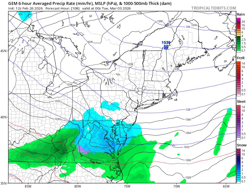
TSSN+ replied to Ji's topic in Mid Atlantic
This is the euro right? Please tell me it’s the euro? Oh no just the gfs…shit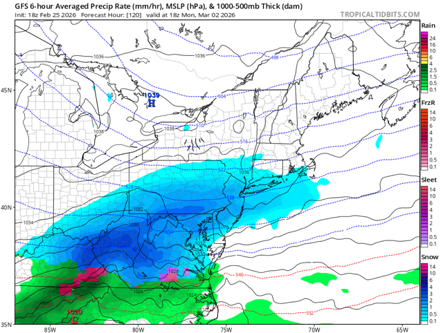
-
@DDweatherman Shits dead