

FXWX
-
Posts
834 -
Joined
-
Last visited
Content Type
Profiles
Blogs
Forums
American Weather
Media Demo
Store
Gallery
Posts posted by FXWX
-
-
3 minutes ago, ORH_wxman said:
Well it doesn't last....even on this NAM run it gets yanked back down to south of MVY....I think the biggest issue is the timing of it. I'm trying to think of any high-end storms that had something similar....2015 started to become very briefly elongated before being captured, but nothing like what is being shown on guidance.
Thanks, Will... at least if this goes bad, we will have something to try to blame... I'm just trying to wrap my head around physically how long and effect a dual structure could survive... sounds like it would not be long. Thus, the impact may not be significant.
-
1 minute ago, weatherwiz said:
I share this same exact question. Going to have to study up on dual low structures after this and the processes behind them.
I'm wondering if we are getting into a bit of over-analyzing? The big footprint pattern aloft has not really changed... We might be so involved with almost model nowcasting an event before it has really unfolded, that we are in a can't see the forest for the trees mentality?
-
 4
4
-
-
3 minutes ago, ORH_wxman said:
NAM still captures it south of islands. Just took longer this run.
Not an expert on the duel low scenario, but given the incredible potency of the upper levels (500 especially) I'm not sure a duel structure can last long before the surface structure gets consumed / consolidated into one very intense low??? I'm open to being schooled here, but how can a duel structure last under this upper air configuration. As 40/70 inquired, do you have any good historic similarities?
-
1
-
-
While no one should be slam-dunking the ball yet relative to final outcomes, congrats to TIP for another tremendous job on identifying a medium range major storm threat!!! Well done...
Also, this is another case in a long line of storms, most nowhere near as dynamic as this one, that understanding the tendency for mid-level forcing to produce more precip further west than initially modeled, is critical.
There will always be concerns about the western extent of mod/hvy precip, and sometimes there will be heart-breaking transitions from tons of snow to very little across short distances. But more times than not you can hedge the mod/hvy qpf west & north of the fronto forcing. As noted above, nothing is a done deal yet with this storm and hopefully all of the positive moves over the past 12 hours or so continue.
Now we should all try to mentally slow this down and enjoy the process & evolution of this storm, and not rush the experience to a close!
-
9
-
-
1 minute ago, CT Rain said:
Holy fu*k
Is that an approved meteorological term...lol
-
1
-
 2
2
-
-
31 minutes ago, 40/70 Benchmark said:
This will be comparable to 1978 in terms of snowfall...nothing else
See... Good things happen to people who are willing to wait and believe in it! Trust your instincts...
-
5
-
-
41 minutes ago, JC-CT said:
No offense, but that's not really fair to dismiss concerns about being on the fringes just because it's a big dynamic storm. March 2014 was as dynamic an upper air setup as they come...just too far east. Not saying this is March 2014, it's not...but there's always a fringe.

No offence taken... It was more about the inference that the ballgame is over for WOR... Hey in the end, it may prove to be correct, but this drumbeat to dismiss this event because the modeled snow gradient appears to remove shot at bigger totals for western areas, as currently stated by quite a few folks, is just not realistic given the nature this storm event. I'm only referencing those that have appeared to have given up. Certainly, concerns are warranted, but throwing the towel in is a bit much... No biggie...
-
19 minutes ago, CT Valley Dryslot said:
All the WOR peeps are either silent or left the thread after that run.
Another mediocré 6" storm for them.
That's only the ones who live and die with modeled snow totals and don't appreciate what a dynamic upper air setup is capable of doing and has done in the past; especially the evolution of that 500 mb low.
-
2
-
 1
1
-
-
3 minutes ago, Typhoon Tip said:
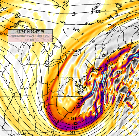
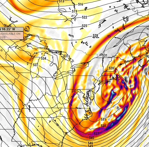
yup ...I wonder if that's also robbing it from being deeper. It's just got incredible deep layer jet structural mechanics...
980 ...um.
Don't get me wrong, that's nice and deep and all. But it seems this 'higher upside' aspect that this has had, really all along ... , is leaving something out on the table. So did the NAM for that matter, as that weird dual low aspect sort of pinches off maybe 20% QPF from getting back W
It's like watching and trying to time a hurricane's eye-wall replacement cycle. I think the modeling is going to struggle to resolve the duel low structure, but in the end, the incredible jet dynamics will take over quicker than modeled and it will go nuclear...
-
2
-
-
17 minutes ago, 40/70 Benchmark said:
This makes me feel better about my big hedge on first call map
Here is the 18z Saturday 700 mb fronto prediction from today's 18z euro run... I think we can live with this???
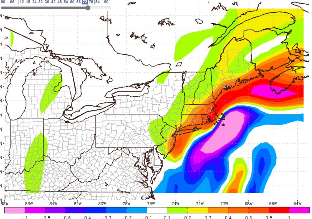
-
9
-
1
-
-
5 minutes ago, CT Rain said:
Yeah that's a pretty good jump west on the EPS. Didn't expect to see that at all.
And a very impressive cluster shifting west.
-
2
-
-
48 minutes ago, 40/70 Benchmark said:
Your thinking changed at all?
Not really... I still like the basic setup (location & intensity of the mid-level features) and try not to do any knee jerk changes when still 48 to 60 hours of go time. I do fully appreciate what Will has been noting about the southern stream but think there is enough time and wiggle room for this to still pan out very good for most of the area. Reading through the posts, you'd get the impression from some, not most, but some out there that this thing is going east of Bermuda. This will still be KU even... The basic layout fo the 850/700/500, etc... still look more than good to produce a widespread heavy, to locally excessive snowfall. Could western CT/MA end up out of the goods, certainly, but I still love the inflow to take care of that to a large extent... Still too much time to try to get too pessimistic about western arears...
-
2
-
1
-
-
10 minutes ago, ORH_wxman said:
Yeah frequently it is, but sometimes it's real. The convective chasing on this storm has been pretty minimal so far...but it definitely seemed like that run did it a little.
I would've expected more QPF to be thrown into central/western SNE based on these two frames:
Yes indeed...
-
When looking at total qpf forecast, which are likely to be a bit underdone in some areas, remember this is highly unlikely to be a 10:1 ratio storm...
-
4
-
-
19 minutes ago, 40/70 Benchmark said:
YES.
I am confident.
Tremendous inflow
Thank you... For western CT/MA, I'm not worried about the location of the main fronto... If the inflow verifies, which is a much more predicable item, there will be great snow totals way west of the fronto projection. Even in modest setups, my rule is to always skew it west & north of the fronto zone... In this setup with the projected inflow, it may be hard to get it to stop going west!!!
-
3
-
2
-
-
3 minutes ago, MJO812 said:
Gfs is holding back more energy. This should be more east.
It's hard to take the Euro seriously here since it has no support except for the Long range Nam.
"Hard to take Euro seriously" is not a hill I would want to die on!
-
1
-
-
Just now, 40/70 Benchmark said:
NAM looks just like EURO.
About fking time... Lol
-
3
-
1
-
3
-
-
1 minute ago, CT Rain said:
I think the GEFS and the UK being so far offshore (plus a fairly far east NAM) definitely are red flags today. Want to see some sizable jumps toward the Euro.
My gut is a Euro-esque solution is more likely but need some 12z jumps. The Euro isn't quite the king it once was.
Still riding the Euro layout, but for comfort level I'd love to see a meaningful move closer to Euro by GFS & NAM. Although, as mentioned earlier by someone this morning, gfs upper look appears good enough to produce a Euro solution.
-
1 hour ago, 40/70 Benchmark said:
WOR....STOP WORRYING.
You have margin for error on that map, and keep in mind...I agree east kicks are still likely, but model QPF is NOT going to capture the full extent of that deformation, so its not far enough west to begin with. NVM that this has so much s stream origin.
This is NOT Juno....this is NOT March 2018.....this is on another level as far as regional impact, though probably similar east.
This will be the most severe regional impactor in 9 years-
Period.
yep!
-
2
-
-
1 minute ago, CT Rain said:
It's also quite slow compared to the Euro.... and has slowed down from 18z.
Cautiously optimistic the pattern is slowly coming together... Would hope (expect) GFS to trend a bit better tonight. Not surprised by the slowing and think that overall trend will help foster a more widespread / high impact event across SNE...
-
1
-
1
-
-
5 minutes ago, Ginx snewx said:
Hey no snow stealing by wind there Mr.
Lol
Refresh my memory, which event a few years back had the westward charging hellacious band with TS+++ / Mix precio+++? That one had an incredible snow drift to it... while the band was east of me by several miles, I had S+++ but the radar was empty over my area...
-
38 minutes ago, weatherwiz said:
That is an absolute crushing in SE MA. With a giant screw job in the CTRV

Hey Wiz... I know you are probably just using this as eye candy right, but hope you realize with an incredibly dynamic setup like this, these fronto banding projections have the ability to jump around big time over the next 3 days; even over the final 12 to 24 hours. Given this is based on the GFS, which I suspect is too far east, I'm hedging the main band will be further west; maybe eastern CT into RI & east-central Mass. Do not under-estimate the ability this to build westward... Also, given the tremendous easterly inflow, I'm guessing there will be a significant westward drift to the heavy falling snow across eastern CT that actually improves snow amounts in parts of the CT Rvr valley. I saw that happen once before during one of our other biggies.
-
8
-
 1
1
-
-
1 hour ago, Typhoon Tip said:
Fifth … 1978 isn’t really good total meteorological analog ?
when did that come up and why/how?
It came up either just prior to the Euro run or very shortly thereafter; 40/70 shut it down pretty quick. Whenever modeling slows a slowing down of an East Coast winter storm, the 78 analog is brought up. But, as mentioned by others, synoptically is not even close. 78 had a full capture, stall and loop. It also had a classic banana high at the surfaces stretching from western NY on across southern Canada out into the Atlantic north of the storm. This has nothing of the sort; high pressure is retreating to its northeast, but no wrapping back of the high on across southern Canada; at least not enough to be noteworthy. This will be an attempt at a capture, but in the end, it will only be able to slow its forward motion; probably not get it to fully stall. I would expect this system will always have some forward motion component, even it crawls for a period of time, as it gets tugged a bit north and northwest.
-
1
-
1
-
-
40 minutes ago, 40/70 Benchmark said:
I agree. When I disputed your point the other day, all I meant was that guidance would over correct in that direction, before ultimately coming back and closing later...however, I fully expected some of these runs to close it off very quickly, and the most likely candidate is always the EURO in my experience.
I absolutely agree that the EURO is too fast and far SW with closing off as it stands now. but I just don't want it to trend too much before correcting. But you are right....that is probably not off of the table. The CF I feel is...I understand why some don't want it discussed yet, blah , blah, but its my opinion.
Agree... At this point, I'm locked in mentally for a big regional event with all the normal caveats. From this point on, want to enjoy the forecasting process; fine tune the snowfall prediction, update my predicted impacts for all of my clients across the Northeast based on my take of the 700 mb intensity & track trends; 850 inflow, etc... The coupled jet structure at 300 mb is a classic big deepener signal. Given the lack of big / widespread events this year, I'm want the next 2 or 3 days be a relaxed run-up to a big event so when we get to Friday, I can just step back and watch it unfold.
-
9
-
1
-


Powerful Multi-regional/ multi-faceted east coastal storm now above medium confidence: Jan 29 -30th, MA to NE, with snow and mix combining high wind, and tides. Unusual early confidence ...
in New England
Posted
I agree