

FXWX
-
Posts
834 -
Joined
-
Last visited
Content Type
Profiles
Blogs
Forums
American Weather
Media Demo
Store
Gallery
Posts posted by FXWX
-
-
9 minutes ago, wdrag said:
Thanks... not seeing any reports of this. Unsure whether BOX has the reports, or they're short staffed? Thank you for this!
Hey Walt; crazy variation across western Hartford County; only a slushy cover at my old location at 300', our current location 3.5" at 700' - meanwhile at under-construction new house at 1140' measured 6.0"... Hope you are well; talk soon.
-
 3
3
-
-
3 hours ago, dryslot said:
Look like 1" so far

Where did you get that particular snow stick???
-
1
-
-
3 hours ago, Typhoon Tip said:
Nice!!! sweet, thanks my 'gender neutral internet hyper PC convention '
No seriously ... are these one times as in now out of mercy, or is there a public access/url ?? Thanks man -
All ens teles are available on WxBell and/or Weathermodels.us; both which are paid for subscriptions... Weathermodel.us is the most reasonable. I need to view them on a regular basis for my work so the fee is worth it... Whenever you want to see them just ask...
-
1
-
-
36 minutes ago, Typhoon Tip said:
I don't know why I keep bothering to update/push a colder/stormier profile over this side of Hemisphere ... ' shit keeps doing this ..
How about this "La Nina" structure, huh? ... wtf This straight up looks to me like my hypothesis back in August - sorry to say. That the "La Nina" ?? ... it's not coupled to the atmosphere. I think NCEP is full of shit in their PDF too ...trying to negotiate an interpretation, is what's up with them, because there is no way in f'ing hell this below ...
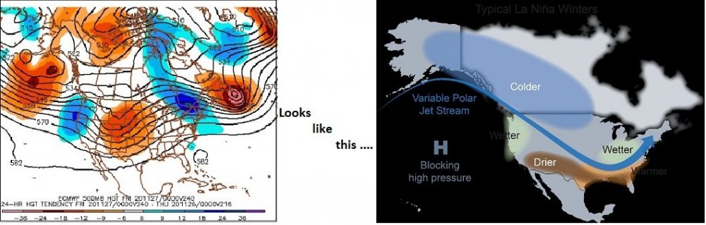
If the general hemispheric eddy was truly coupled to the La Nina ... we wouldn't have EL F'ING NINO JETS COMING INTO CALIFORNIA! ... assholes... Stop selling interpretations, put down the coffee and Solitaire, and do your jobs.
Oh shit I'm kidding... I'm sure they're all Master's and Phd asperger focused socially dysfunctional geniuses ...
However, I don't agree that the hemisphere is "coupling" to any forcing by the ENSO state.. .because I've grown tired of reading their ENSO publications, then ... fielding these kind of modeling complexions by the Euro ( left ) above, (...having them more less verify as we are seeing enhancing precipitation into the at least N. Ca up through Wa/Or ). I said in August ... if not an exact quote, ' La Nina may happenstance look like that from time to time, as the pattern migrates through the idealized mode, but it won't be because of the La Nina... ' - it was in deference to the idea that the HC is muting these ENSOs because it has expand beyond and completely engulfed the normal "triggering latitudes" where their modulation then forces patternization. In this case...I suspect with having wind flux anomalies in the mid latitudes that have been raging since...oh, 2002 ... there has to be a compensatory mass somewhere... Some of the wind channeling off toward polarward motion ...spliting N into the WCBs from cyclonic/trough gestation... But some of it by convention does split S and ends up underneath, and thus ...you have [ possibly ] enhancing easterly trades, purely as a function of more in must move more along those lower latitudes... causing SS stressing and plying the surface oceanic temperature distribution into mimicking La Nine; as the base-line state, but not really indicative of actually having one. I'm starting to wonder .. is that intrinsically misleading...So, we end up expecting to see the right annotation above, but because the total hemisphere is really ...doing something else, the left panel keeps existing
Hypotheticals aside/here and now:
Thing is ... I wasn't making that other stuff up re the GEFs ( at least - for how little they must be worth ) derived teleconnectors. They were/are biased toward a colder/stormier suggestion ... enough so that even if they don't ultimately verify a convincing look, when moving the mode of the AO down, the NAO down, and the PNA up ...that synergy typically gets interesting ( at least) .
But this? Above? Even the operation GFS is doing this ... and altogether, the operational runs are kind of in some sort of epic tug-a-war against that. It's like some agency is designing this to deliberately create a futility in the art of predict lol
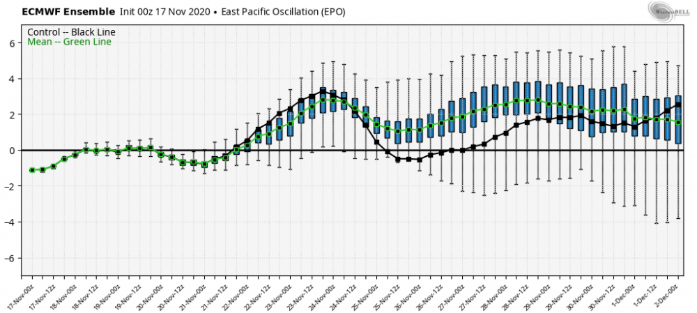
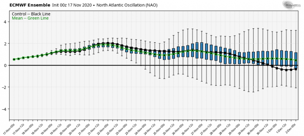
The EPS ... does anyone have those numbers?
Like ... I don't wanna read anyones interpretation... I want to see
EPS NAO = ?
EPS PNA = ?
EPS AO = ?
...The only ones available to the easy-to-find Internet/Americas appears to be the MJO coverage offered at the Climate Diagnostic Center.
-
28 minutes ago, WinterWolf said:
I guess we’ll see? I wouldn’t be buying all in just yet. Those are usually overblown, and ya even a blind squirrel finds a nut sometimes. Let’s See what tomorrow’s modeling shows?
I am well aware of the history of over-done max wind gusts by modeling, but if you have been closely following the short-term record (past year) of the euro ever since last fall, it has been remarkably good with at least 4 significant events... Maybe it craps the bed this time around, but it deserves to be taken seriously, as far as I am concerned... especially when it has multiple runs with these numbers...
-
2
-
 1
1
-
-
53 minutes ago, Ginx snewx said:
Someone needs to get that whole video from the East Haven High School turf field as it definitely shows the Tornado
Steve; where are you seeing the clip from East Haven HS turf field video? Do you have a link?
-
2 hours ago, Typhoon Tip said:
Not to be a douche and you don't know me ...I don't think .. but, I don't believe that front actually can move NE of it's current position looking at this at a broad conceptual approach to this situation. ..as in fluid mechanically it can't. Then, after that notion... one has to consider New England's climatology with BD-pinned fronts, which is just a dense clay of other geographical feed-back no-no's - eesh
The flow is paralleling the boundary; it's like all of the analytic Meteorological brain trust has gone mad. When do warm fronts penetrate through an abrasion flow? That is like ..physically impossible.
This situation seems(ed) dead to me when I saw that yesterday in the models..W-NW flow at mid levels. What is SPC using? Now, granted ...that shuts off any hope of "SB" in the SB CAPE.. but elevated... mmm maybe. But they are not talking about "elevated" per se convection in the morning write up...
Which, by the way folks - there's currently a cut-off vortex near the 50N/50W position slopping cat -paws over eastern Ontario above the 50th parallel, and that feature is pinned in position. That backlogs the W-NW or arguably more NW flow at mid levels here, which pins the warm front there... end of discussion.
Now, this was all modeled ..I am actually interested in how SPC came by their enhanced geographic layout - because looking at these very real and reasonably well modeled synoptic circumstances, I don't see how they come by their risk assessed region like that.
The only way I see Enhanced clear to Springfield Massachusetts ... is if clearing opens up sun almost entirely ( 90% open ceilings/cloud extraction) and the atmosphere gets diabatically forced by the sun... but, the sun is now mid April in intensity ... ( for perspective ) ...It's not May-July out there so even so, its harder for the sun to do that at our latitude and depth of atmosphere east of Berkshires .. Moot anyway looking at sat trends...
However... ugh, I am - reluctantly - interested in if there is an elevate hail risk where any stronger convection that is feeding purely off the 850 upglide parcel lift on the flop side of the front, and is paralleling it racing SE... yeah...maybe. But, we may as well not even call this a warm front. .. There is a 101 synoptic term that is out there available for this sort of phenomenon and it is called a "stationary" front. And, with the mid level flow abraded(ing) SE that like it is ... sawing off any warm intrusion attempting to mix down... that leaves only one possibility - the models are/were wrong ( but so far nearing mid morning the pinned front is well handled)
I guess if the vortex NW of NS/NF weakens during the day, and the mid level flow veers slightly... and the stationary boundary does actually "warm" for a period of time...it might intrude into CT ..but that's not modeled to do that... I don't think ?
Douche away; I'm a big boy, I can take it; lol. I have read enough of your post to know you have a great handle on the dynamics of the atmosphere. Your statements about sfc/upper air pattern analysis versus modeled frontal & sfc pressure center positions are never taken lightly by me. It is something I try to constantly remind myself about. There are many times I just look at the sfc & upper air analysis and physically draw what that look should lead to in terms of feature placements. I do think the pattern layout described in your post above certainly is not one usually favorable for a warm front to bodily rush across SNE. But skies have really cleared out of all most all of CT, as well as southeastern NY, temps are rising quickly across western CT, but the rich dew points are still sitting down across portions of eastern PA/NJ. Certainly not a classic summertime warm front passage? Southeastern NY and western / southwestern CT were my main concern area and that continues. The increasing sunshine across CT may open the door to the threat migrating into central CT, as well as the greater Springfield area, but dew points really need to get going. Noted SPC is yet to issue a MCD for this afternoon, which tells me they are not as bullish right now, even though their updated outlook remains mostly unchanged.
-
1
-
-
1 hour ago, Damage In Tolland said:
We have no problems ripping warm fronts thru in winter yet in the hottest summer on record for all of us and boiling SST’’s it wants to hang up along the immediate s coast
I told you yesterday to never trust a warm front's modeled position. This had a pretty solid cold/cool air mass sitting across eastern New England and it should not be shocking it is struggling to blast northeast across SNE. That being said, still an interesting setup and you cannot dismiss some of the basics in play with this event; just yet. Could still turn into a solid northwest flow event, but this has almost always looked like a southeastern NY / west-southwestern CT deal. The question now is can we destabilize enough on the back side of the warm front or will cloud debris put a nail in the instability coffin. Things can and often do change quickly and anyone dismissing the possibility of this becoming a nasty event for western CT should wait a bit.
-
1 minute ago, wdrag said:
It seems to be in error... HOWEVER, I think some sort of center will remain intact across there Apps (VA-s NJ) with squally 40-50kt gust potential s of the center, which eventually probably ET transitions to an intensifying n Atlc storm in its rapid poleward departure. What has caught my attention now, is the 12z GFS with seemingly a weak boundary in CT Fri night. That may serve for a weak PRE... unsure, but any boundary in our forum area with this pwat coming up to ~2" so let loose at night.
Agree...
-
4 hours ago, wdrag said:
Good Tuesday morning everyone, No significant change to my update of Monday morning.
Timing has slowed slightly but otherwise I think everything looks good for a moisture infusion and potential for some heavy rains in parts of our forum. The primary event looks to be centered mostly Saturday.
Added some NAEFS (52 member graphics), inclusive of the 24 hr QPF axis, the ensemble low position Saturday evening (it's a broad area of low pressure. and imagine there will be 2 lows, one further north in or near the eastern New England coast, and one down off Virginia or Delaware at that time,) jet dynamics (200mb jet core over the Canadian Maritimes leaving us in the RRQ). and finally the probability of more than 1" axis between Wednesday evening and Sunday evening-showing the primary qpf axis with this tropical influenced pattern. 551A/25


Hey Walt; nice job as usual. What do you make of the UKMET being so persistent with its deep and intensifying system???
-
3 minutes ago, FXWX said:
Across my area Burlington, CT; very impressive tree damage town-wide... Multiple reports of trees taking down or snapping poles; with multiple poles being snapped at the same location... we actually have town work crews that cannot get out of some areas since more trees have come down and blocked all their travel routes.
Town Crews just pulled off the road until winds subside; will respond only to life-threatening situations!
-
Across my area Burlington, CT; very impressive tree damage town-wide... Multiple reports of trees taking down or snapping poles; with multiple poles being snapped at the same location... we actually have town work crews that cannot get out of some areas since more trees have come down and blocked all their travel routes.
-
2
-
-
Just now, weatherwiz said:
Is OKX radar down? Not loading anything on Radarscope
still good here...
-
3 hours ago, metagraphica said:
Anyone have any reports from Old Lyme, CT? We had tiny hail here but they had radar indicated golf ball size not too far south of me.
Severe Weather Statement
National Weather Service New York NY
349 PM EDT Mon Jun 29 2020

CTC011-292045-
/O.CON.KOKX.SV.W.0036.000000T0000Z-200629T2045Z/
New London CT-
349 PM EDT Mon Jun 29 2020

...A SEVERE THUNDERSTORM WARNING REMAINS IN EFFECT UNTIL 445 PM EDT
FOR SOUTHWESTERN NEW LONDON COUNTY...
At 348 PM EDT, a severe thunderstorm was located near North Lyme, or
near Salem, moving east at 5 mph.

HAZARD...Golf ball size hail.
SOURCE...Radar indicated.
IMPACT...People and animals outdoors will be injured. Expect damage
         to roofs, siding, windows, and vehicles.

This severe storm will be near...
  Waterford and East Lyme around 445 PM EDT.

PRECAUTIONARY/PREPAREDNESS ACTIONS...

For your protection move to an interior room on the lowest floor of a
building. Prepare immediately for large hail and deadly cloud to ground
lightning. Seek shelter inside a well-built structure. Stay away from
windows.

LAT...LON 4148 7212 4135 7220 4141 7236 4143 7234
      4144 7231 4148 7231
TIME...MOT...LOC 1948Z 275DEG 5KT 4143 7228

HAIL...1.75IN
WIND...<50MPH

JP
Old Lyme

-
5
-
2
-
-
1 hour ago, CoastalWx said:
That's your classic morning WF passage with storms like we had on 6/1/11. Rapid destabilization after passage.
Add the July 10, 1989 to the similar setup; morning WF passage and then monster afternoon / early evening event...
-
1
-
-
7 minutes ago, Damage In Tolland said:
Map?

-
1 hour ago, Ginx snewx said:
Looks like the change line is near Saco, Gray cam and Augusta


Check out live August airport cam... https://www.maineinstrumentflight.com/fbo/webcams/

-
1
-
-
2 minutes ago, Damage In Tolland said:
CT stopped sand years ago. I forgot how much I hated it. It’s on every back road, every company ,every college I went to. Sand as far as eye can see
Not completely; maybe state DOT, but I have several DPW crews that have used it when bitter cold periods were in play; used quite a bit Jan/Feb 2015.
-
3 minutes ago, Damage In Tolland said:
What’s with all the sand they dump everywhere here? There’s sand ground blizzards today . Face a scar pelted numerous times. I didn’t think anyone used sand anymore due to the environment. It’s everywhere
Many of the new treatments are less or ineffective during very cold periods, which are common across NNE; sand allows for better traction when treatments would not be effective. Even down here in SNE, some DPW crews have a reserve of sand to use if needed during very cold periods.
-
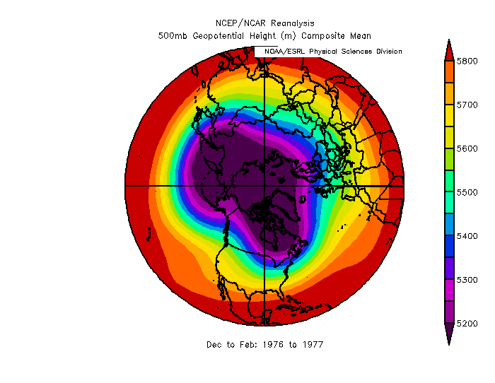
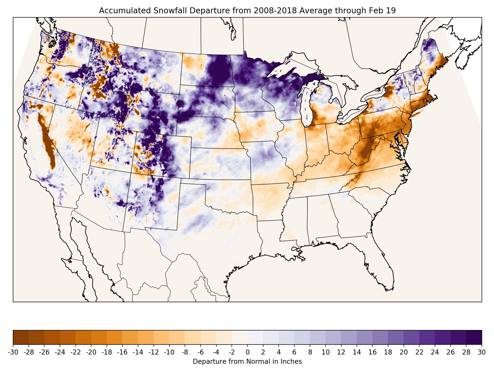
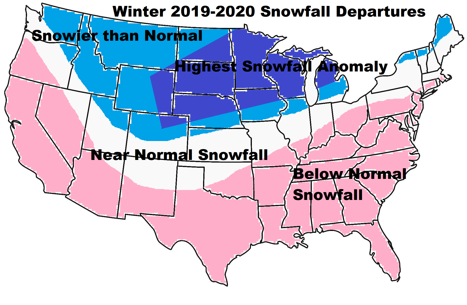
11 hours ago, Isotherm said:
This winter has continued the theme of "stagnancy" - that is, absent novel forcing mechanisms, we maintain a similar set of indicators, and thus, z500 regimes tend to repeat. For example, the SSTA profile in the Atlantic has been quite similar since 2017, which has been reinforcing the humid/warm summer signal in the East. This winter featured many of the same indicators as 2018-19, and as a result, the mean storm track followed suit.
These snowfall departures with respect to normal have a base period of 2008-2018, but still impart the general picture of snowfall anomalies to date [h/t Eric Snodgrass].
Underneath that image is my snowfall anomaly outlook for this winter. The season is not over yet, but I'm quite content to see the anomalies are highly congruous with my pre-season expectations. Upper-Mid-west and northern Maine jackpots.

Great job with your forecast... can you share the link (url) to the Accumulated Snowfall Departure map?
-
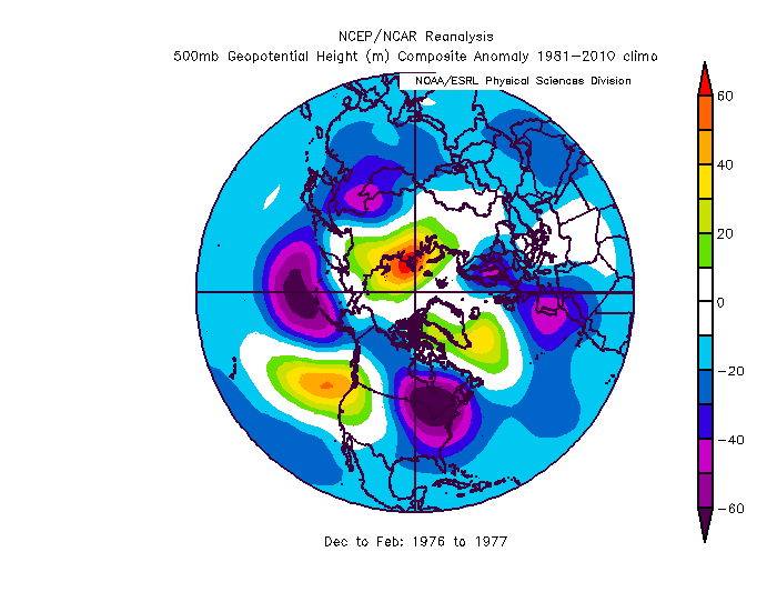
Hey Walt... didn't have time to play with the scaling but here are the 500 mb mean and anomaly maps for Dec 76 through Feb 77...
-
1
-
1
-
-
1 hour ago, Damage In Tolland said:
This year you have to favor warmest and not snowy outcomes. What can go wrong does and outperforms itself. My point is there’s something globally/ atmosphericically this winter that all of us and modeling has missed or is missing.
Globally (NH), we have gone through a remarkably long stretch of a relatively flat flow with zero blocking, no persistent large-scale amplified trough / ridge couplets; no real anchor features; true arctic air has not be a regular visitor to the middle latitudes anywhere across the NH. Why??? I have no clue. Even in many of our blah / ratter winters, there were strong features causing havoc elsewhere; this year not so much. The oceans are very warm on a widespread basis though and maybe the lack of sst gradients are playing a role???
-
1
-
-
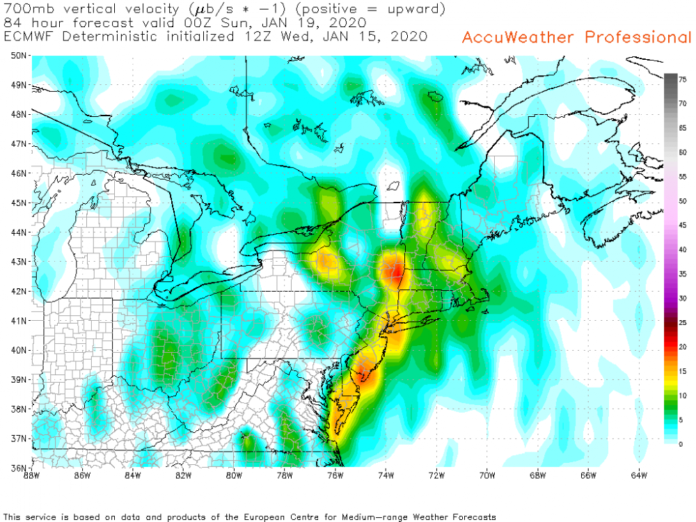
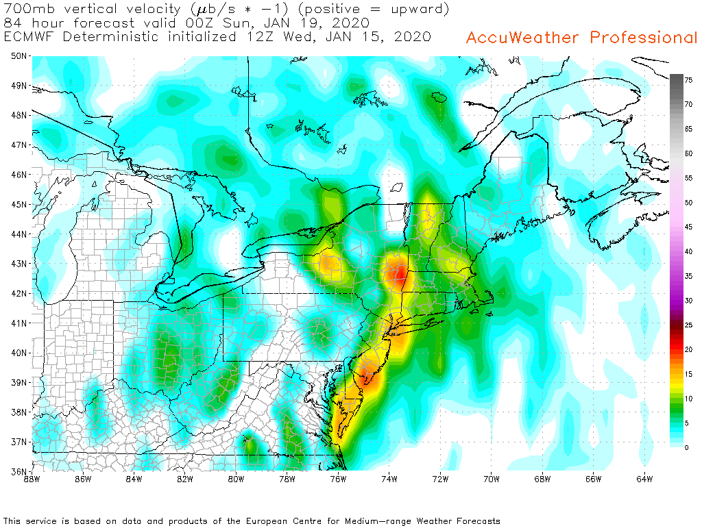
9 minutes ago, ORH_wxman said:
There's actually a pretty good crosshair sig on the GFS but it's still 72-84 hours out.
Can't see euro omega but the temps in the 600mb range are pretty nice which is often where that initial burst of lift is.
So it's possible we get some nice ratios but I'd be careful about counting on ratios this far out. I typically never forecast high ratios unless it's slam dunk and inside 36 hours or so.
Here is Euro Omega (700) at 00z Sunday
-
4
-
-
1 minute ago, Sey-Mour Snow said:
My observation it’s definitely steady light to moderate snow. Sticking to everything including roads. I’m about 6 miles SSE of OXC.
Ok... small, localized enhanced areas; just a bit to your north OXC showing 10 mi. vis... hope you pick up a solid cover; sfc temps not helping out in many places... thanks for ob


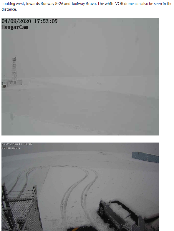
December 5-6, 2020 Storm Observations and Nowcast
in New England
Posted
I sent overall all 3 with amounts and elevations; right now only 3.5 listed...