

FXWX
-
Posts
838 -
Joined
-
Last visited
Content Type
Profiles
Blogs
Forums
American Weather
Media Demo
Store
Gallery
Posts posted by FXWX
-
-
9 minutes ago, tavwtby said:
dude I remember that, my birthday storm that year, got 2" of grap chicken stars soup stuff in Waterbury, while prospect got like 8-10" just a few miles away
Given the widespread hilly terrain induced snowfall differences across much of CT, including portions of Fairfield and New Haven counties, road conditions can vary tremendously across one town... Just another item in the mix that school districts try to determine the best course of action. I remember storms where you could literally have a normal school day on the south side of Wolcott, but it was a no go across the north side of town near the Bristol border. Unfortunately, there they don't cancel schools for just a certain number of streets. Tomorrow comes down to snowfall rates and whether or not DPW crews can keep roads mainly wet or a bit slushy if rates stay under 1" per hour. The answer should be yes, but if an area gets into solid banding for 2 or 3 hours then all bets are off...
-
8 minutes ago, EastonSN+ said:
I was watching TWC last night and a place in Arkansas has 2 inches of pure sleet!
While most on here understand, many folks forget how disruptive heavy sleet can be...
-
 1
1
-
-
16 minutes ago, EastonSN+ said:
Euro cut back again for southern CT.
Euro qpf actually increased from 6z considerably across CT; back to just under an inch across srn CT... this is all about how quickly a flip to sleet occurs; miss that timing by an hour or two and snow amounts are back to 4+ inches... Could be a crap load of sleet & ice???
-
 1
1
-
-
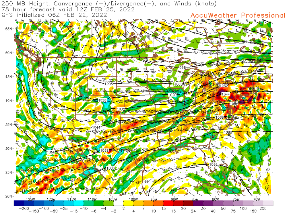
22 minutes ago, Typhoon Tip said:
Been hammering this facet ( I know ...) but, in addition to you being not only right, this
https://www.pivotalweather.com/model.php?m=gfs&p=300wh_nb&rh=2022022200&fh=84&r=na&dpdt=&mc=
...over -saddling the region with superb evac, **ADDS** to your assessment.
Dude, this is going to over-achieve ( I feel ...) - as a back office/water cooler muse... But unless these metrics resolve differently, this will probably outdo the QPF max zones because there will be impossible to pin-point uncertainties wrt to meso banding ... forced by organizing frontogen/UVM slots by that diffluent mechanical layout there.
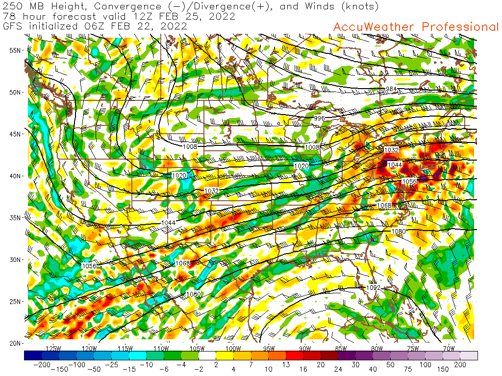
The convergence / divergence model plots are also indicative of maxing out qpf... both 300 & 250 mb model plots, as indicated in the 6z gfs run at 7 am Friday, show a strong signal for heavy precip totals..
-
1
-
1
-
-
38 minutes ago, Great Snow 1717 said:
3 snow/sleet events for the entire winter.....for those in the plowing business it has been a terrible winter.
Most, not all, of the snow removal / maintenance folks I deal with decided to go with a yearly fee this winter and are perfectly happy. I have discussions with my clients in Aug/Sept and discuss whether to play the odds of a yearly fee or a per storm contract. This year most decided to roll the dice with a yearly fee option, and are happy, so far with the winter tenor.
As for the litigation side of things, I deal with many dozens of those case every year. Juries are quite open to siding with the snow removal guys, if they can show a well-documented work procedure. I always recommend an after clean-up brief video, or at least pictures with a logbook of times of cleaning and treatment applications. Most juries understand the nature of Northeast winters and fully understand it is impossible to clean surfaces to perfection; especially when dealing with parking lots / driveways and walkways that were being used during an event. The key is to document, take pics and/or video each storm. It might sound tedious, but it can make all the difference when it comes to lawsuits.
-
2
-
-
14 minutes ago, CoastalWx said:
I feel like if it did not hit someone's backyard...it seems to get downplayed. If aerial coverage is weighed in, sure. But saying something "in the least plausible way" insinuates something limped into that category. I don't see how you can say that?
Agree... If you thumb through the KU book and use the MBY mentality as your guide, any one person could cross out about 70% of the events. We could rename the book from 'NORTHEAST SNOWSTORMS" to something like "NORTHEAST SNOWSTORMS FOR SOME; NOT SO MUCH FOR OTHERS?"
-
1
-
 4
4
-
-
53 minutes ago, dryslot said:
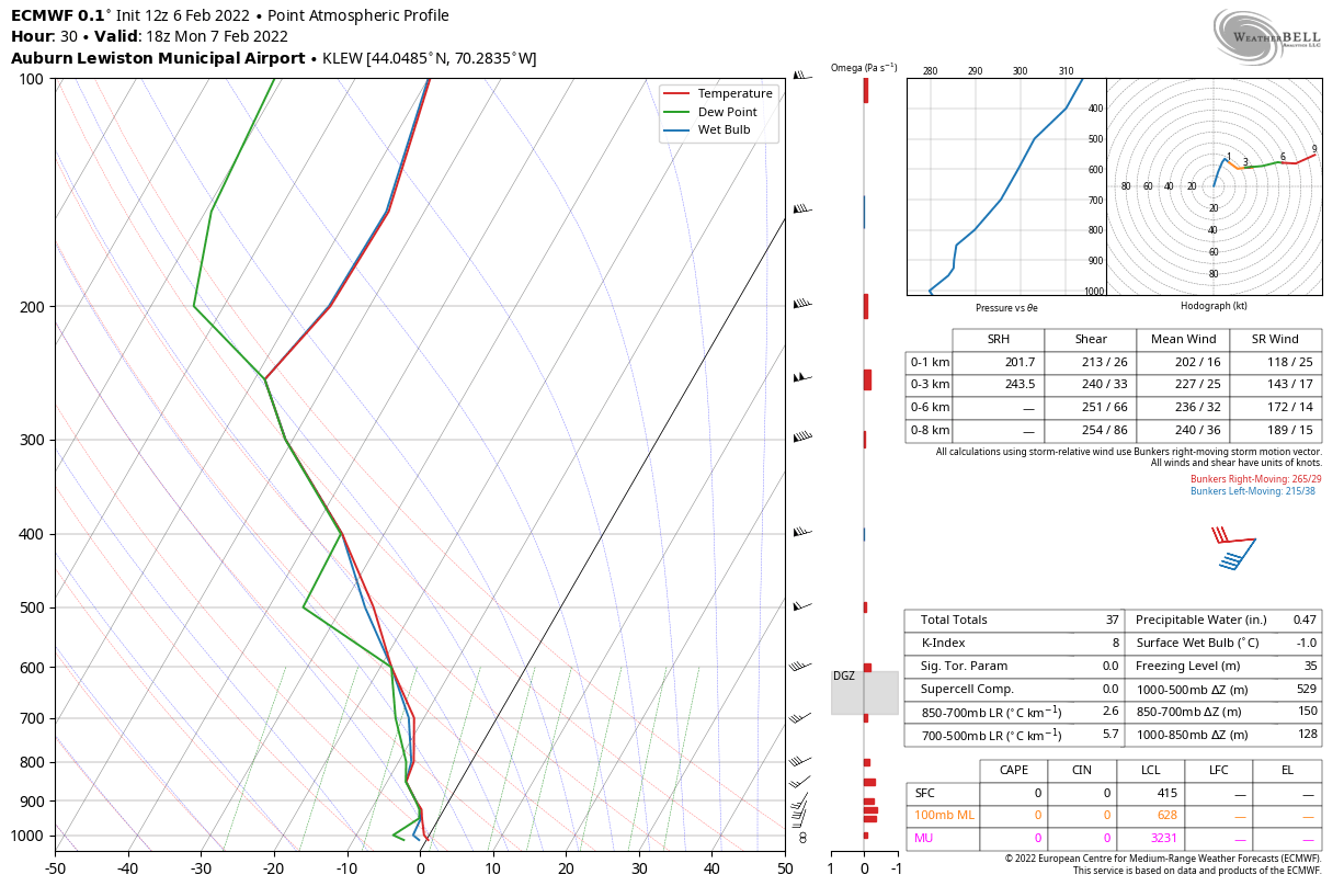
Need to see a sounding, Awful close just from a surface perspective that's a thump on the 12z Euro here of mash.
-
1
-
1
-
-
11 minutes ago, RUNNAWAYICEBERG said:
That’s why it’s better to not to watch. There’s nothing to see for us SoP. A little partying glaze here later this morning and they schools down, weak.
Maybe you should contact your local school board and volunteer your expertise to make the call about if and when road surfaces might become hazardous! And of course, give them 100% certainty about road conditions, sidewalk & parking lot conditions during the 2-hour window needed for a complete bus run on early dismissal days. Maybe also take on all the legal and insurance liability should you be off by a few minutes and an icing situation causes a bus accident... Make sure you coordinate with all other towns your town may share bus routes & programs with? Lastly, when they ask you about the WXA that is effect, tell them not to worry about it's just a NWS scare tactic. Of course, if travel becomes hazardous during the bus trips home, get ready for your phone to ring endlessly as parents scream at you that there was a WXA being in effect! Just some comments from a guy who has spent more than 30 years fielding questions and organizing conference calls with dozens (90 to be exact) of Superintendents at 4 am during potentially hazardous conditions. They all want to have normal days. But they will almost always err on the side of safety unless the confidence level of no chance of hazardous travel is high.
-
9
-
-
1 minute ago, tavwtby said:
no
lots of school around here already called it, I know Winsted and I think region 7, looks like the front is right on my doorstep, 32 and below at the NYCTMA borders, it's down to 37 here now
Yes, a handful so far; most within the group I deal with other than Region 1, Region 7, Winsted and Torrington have closed already; others I deal with are hoping that when we chat at 4 am there will be a slot to get in and get out before it gets bad ... Looks unlikely...
-
1
-
-
14 minutes ago, CT Rain said:
Yea I feel like the 12k/3k NAM are easy closing calls. Gets pretty cold pretty quickly.
Weird how the Hudson Valley drain tries not to bodily spill eastward into western CT?
-
Just now, CT Rain said:
FWIW for the ice lovers south of the Pike... the 00z NAM is quite a bit colder (and faster) than the 18z was.
That's all I want... just to make the morning school decisions to be easier and not second-guessed!
-
1
-
-
18 minutes ago, tavwtby said:
was just going to post, down to 40/40 with mod RN, after reaching 45 just a couple hours ago, I can feel the cold air coming, just hope it ain't ZR, I will take anything but
Keep posting obs through the evening; big help to me...
-
2
-
-
6 minutes ago, Damage In Tolland said:
Yeah same here. Under the powder there was 3.5-4” of glacier. Haven’t seen grass since Jan 5th. That will be gone . You may keep yours being in NW CT .
We will see... The shame of this winter, in particular January, is that we put together a very decent cold month; generally -2.5 to -3.0 departure. And we will very close pattern-wise to a big snow month, but it just did not workout. Unless you count the first 3 or 4 days of January, it was an unusual January in that it did not feature the typical Thaw period.
-
9 minutes ago, Damage In Tolland said:
It will be wiped out. These two days got much warmer than expected. Already into the 40’s. Runaway and others get their wishes
While this winter has under-produced given the temperature layout, I've had snow cover since January 6th! That is an unusually long run or measurable snow for these parts of SNE. Even during many of my past well-above normal snow seasons, the ground would get bare within 2 weeks... Many folks don't realize how common it is to have bare ground during the winter here in SNE. We rarely have long running (more than 2 weeks) periods of snow cover. Also, my current snow cover is glacier like; it's not completely disappearing.
-
6
-
-
40 minutes ago, HoarfrostHubb said:
I would think that is very likely. Ice and sleet are the bane of superintendents
Very much so...
-
16 minutes ago, Ginx snewx said:
Ray got screwed so it was meh to the other 5 million people

Does anyone know why the BOX PNS did not include any Hartford Cty totals, and for that matter none from Tolland County in their final issuance. Also, very few Cape totals even though there are many spotters there? Why post this map without any Cape data? When I review the PNS, it appears to be mainly CoCoaHS site reports, which usually state the distance to a nearby city center. Very few reports from just specific towns? Also, no longer a reference to trained spotter, media, etc...
-
1
-
-
18 minutes ago, Ginx snewx said:
Lol wut.
PNSBOX
CTZ002>004-MAZ002>024-026-RIZ001>008-012245-

PUBLIC INFORMATION STATEMENT
NATIONAL WEATHER SERVICE BOSTON/NORTON MA
150 PM EST MON JAN 31 2022

...BLIZZARD OF 2022 - FINAL DETERMINATIONS...

BLIZZARD CONDITIONS WERE REACHED AT SEVERAL LOCATIONS ACROSS
RHODE ISLAND AND EASTERN MASSACHUSETTS ON SATURDAY, JANUARY 29,
2022. LIGHT SNOW BEGAN LATE AT NIGHT ON FRIDAY, JANUARY 28. SNOWFALL
TOTALS OF 12 TO 24 INCHES WERE COMMON ACROSS THOSE REGIONS, WITH
LOCAL AMOUNTS UP TO 30 INCHES REPORTED SOUTH OF BOSTON. WIND GUSTS
REACHED HURRICANE FORCE ON CAPE ANN, CAPE COD, AND NANTUCKET DURING
THE STORM.

THE DEFINITION OF A BLIZZARD IS THAT FALLING AND/OR BLOWING SNOW
REDUCES VISIBILITY TO BELOW 1/4 MILE ALONG WITH WINDS THAT
FREQUENTLY GUST TO 35 MPH OR MORE. THESE BLIZZARD CONDITIONS MUST
BE THE PREDOMINANT REPORTED CONDITION FOR AT LEAST 3 CONSECUTIVE
HOURS.

WHEN REVIEWING WHETHER A PARTICULAR OBSERVATION LOCATION HAD
BLIZZARD CONDITIONS, WE CONSIDERED VISIBILITIES EQUAL TO 1/4 MILE
BECAUSE THAT IS QUITE LOW FOR AN AUTOMATED SENSOR TO BE ABLE TO
DETECT IN SNOW OR BLOWING SNOW.

THE FOLLOWING STATIONS RECORDED BLIZZARD CONDITIONS...

IN RHODE ISLAND...

PROVIDENCE (KPVD)...5 HOURS 18 MINUTES, FROM 921 AM TO 158 PM AND
FROM 210 PM TO 251 PM.

WESTERLY (KWST)...6 HOURS 16 MINUTES. CRITERIA WERE MET FROM 911 AM
TO 1146 AM, FROM 1153 AM TO 301 PM, AND FROM 420 TO 453 PM.

NEWPORT (KUUU)...9 HOURS 28 MINUTES CONTINUOUSLY, FROM
725 AM TO 453 PM.

BLOCK ISLAND (KBID)...6 HOURS 37 MINUTES CONTINUOUSLY, FROM
705 AM TO 142 PM.

IN MASSACHUSETTS...

BOSTON (KBOS)...7 HOURS 39 MINUTES CONTINUOUSLY, FROM
815 AM TO 354 PM.

WORCESTER (KORH)...8 HOURS 27 MINUTES. IT WAS CONTINUOUS FOR 8 HOURS
16 MINUTES FROM 749 AM TO 405 PM. CONDITIONS ALSO WERE MET FROM 432
PM TO 443 PM.

BEVERLY (KBVY)...6 HOURS 9 MINUTES. CONDITIONS WERE MET FROM 853 TO
1153 AM, 1225 PM TO 201 PM, 253 PM TO 353 PM, AND FROM 453 PM TO 526
PM.

LAWRENCE (KLWM)...5 HOURS 14 MINUTES. BLIZZARD CONDITIONS OCCURRED
FROM 1254 PM TO 245 PM AND FROM 331 PM TO 654 PM.

HYANNIS (KHYA)...AT LEAST 6 HOURS 33 MINUTES. BLIZZARD CONDITIONS
WERE CONTINUOUS FROM 704 AM TO 1232 PM, BUT THEN REPORTING WAS
INTERRUPTED UNTIL LATER IN THE AFTERNOON. BLIZZARD CONDITIONS
RESUMED FROM 505 PM TO 539 PM AND FROM 548 PM TO 619 PM.

MARSHFIELD (KGHG)...12 HOURS 0 MINUTES. BLIZZARD CONDITIONS WERE
CONTINUOUS FOR 10 HOURS 40 MINUTES FROM 435 AM TO 315 PM. THEY WERE
AGAIN MET FROM 335 PM TO 355 PM AND FROM 415 PM TO 515 PM.

MARTHA'S VINEYARD (KMVY)...9 HOURS 17 MINUTES CONTINUOUSLY, FROM
743 AM TO 500 PM.

THE FOLLOWING STATIONS EITHER CAME CLOSE OR WERE UNABLE TO
BE DETERMINED...

NANTUCKET (KACK) CAME CLOSE, WITH BLIZZARD CONDITIONS FOR A TOTAL
OF 4 HOURS 32 MINUTES, BUT THERE WAS NOT A 3-HOUR CONSECUTIVE PERIOD.

NEW BEDFORD (KEWB) MET CRITERIA FOR A TOTAL OF 2 HOURS 30 MINUTES,
BUT THERE WAS NEARLY A 3 HOUR GAP IN THE CONDITIONS.

CHATHAM (KCQX) MET CRITERIA FROM 816 AM THROUGH 852 AM, BUT AT THAT
TIME, THE POWER WAS LOST AND NO DATA WERE RECEIVED.

FALMOUTH (KFMH) MET CRITERIA BEGINNING AT 650 AM, BUT VISIBILITY
READINGS CEASED AT 746 AM. SO, ALTHOUGH WINDS WERE GUSTING ABOVE 35
MPH CONTINUOUSLY INTO THE AFTERNOON, A BLIZZARD WAS UNABLE TO BE
DETERMINED WITHOUT THE VISIBILITY READINGS.

SMITHFIELD (KSFZ) MET CRITERIA FROM 806 AM TO 827 AM AND FROM 853 AM
TO 956 AM, BUT THEN ALL WIND DATA WERE LOST AND THUS A BLIZZARD WAS
UNABLE TO BE DETERMINED WITHOUT THE WIND READINGS.

PROVINCETOWN (KPVC) HAD NO DATA AFTER 556 AM AND THUS NO
DETERMINATION COULD BE MADE.
My daughter lives about a mile from KFMH AWOS unit... I checked her ring cam every 30 minutes and for about 8 hours I could not see the house across the street. No doubt KFMH would have verified blizzard if visibility sensor did not fail.
-
10 minutes ago, CT Rain said:
The Euro/GFS have totally different evolutions in the northern stream and where to set up the confluence. To Will's point the high on the GFS is able to develop over QC with enhanced confluence at H5... while the Euro is far more amplified with the jet and the entire thing goes north and the high never presses into New England. Tough forecast.
Yep... With this setup and modeled differences, no need for anybody across SNE to suggest a confident forecast for a couple more days. At this time, I'm just running with the range of possibilities; suggesting a transition event, but pretty strongly staying away from an all or mostly snow event.
-
1
-
-
32 minutes ago, Damage In Tolland said:
Sure hope that’s the case with this. We don’t want 12-30” of snow pack wiped out in less than a day
I would bet against a complete wipe-out; at least in this area snowpack is very dense.
-
26 minutes ago, Damage In Tolland said:
Shabbs brought up good point on text . TX last Feb. Said euro got destroyed by all other models. Had them torching and we know how that one ended up . All depends on position of arctic front
From what I've seen over the years, Euro can be slow to the party in cold press events... If fact, historically, true cold presses with solid arctic high pressure involved, tend to press more than modeled unless associated with a much stronger low than modeled right now. Back in the day, the old retired NGM was the model of choice in cold press setups...
-
2
-
1
-
-
19 minutes ago, ORH_wxman said:
The December 2008 ice storm also started as rain in ORH....we flipped over sometime during the afternoon on Dec 11th, but it didn't really start glazing well until closer to sundown.
November 17, 2002 featured a very damaging ice storm that caused big time damage across northwest CT (Litchfield County), the higher terrain areas of western Hartford County and northern New Haven County... Tremendous tree and power pole damage. Started as rain during the afternoon on into the early evening before changing to freezing rain as cold air undercut the milder air sitting across the region; along Rt 69 heading from Bristol into Wolcott there was a stretch of about 10 poles snapped all in a row!!!
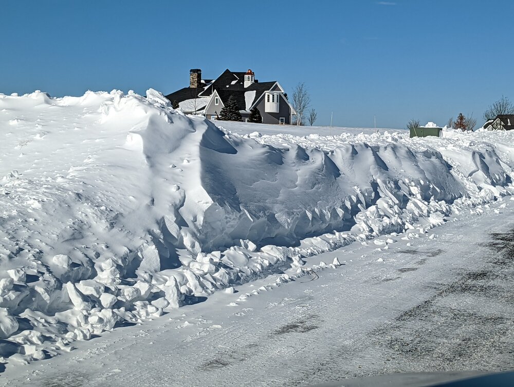
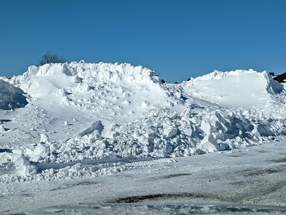
-
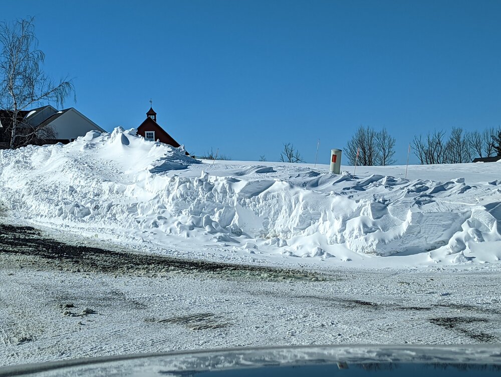
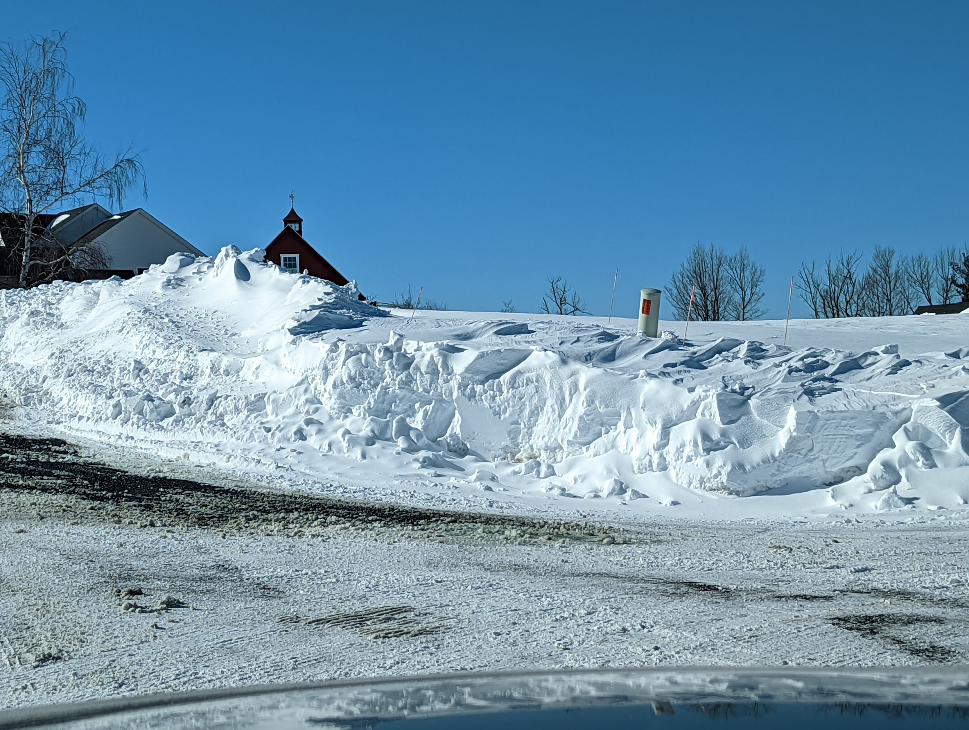
This is what it looks like after clean up at 1,160 feet in far western Hartford County (about quarter mile from Litchfield County line) after ~10 inches of snow and frequent wind gusts above 35 mph.
-
11
-
-
6 minutes ago, Ginx snewx said:
I am lucky. fenced-in 8 foot and level area. Very little drifting, tree fall or roof contamination plus I triangulate to double check.
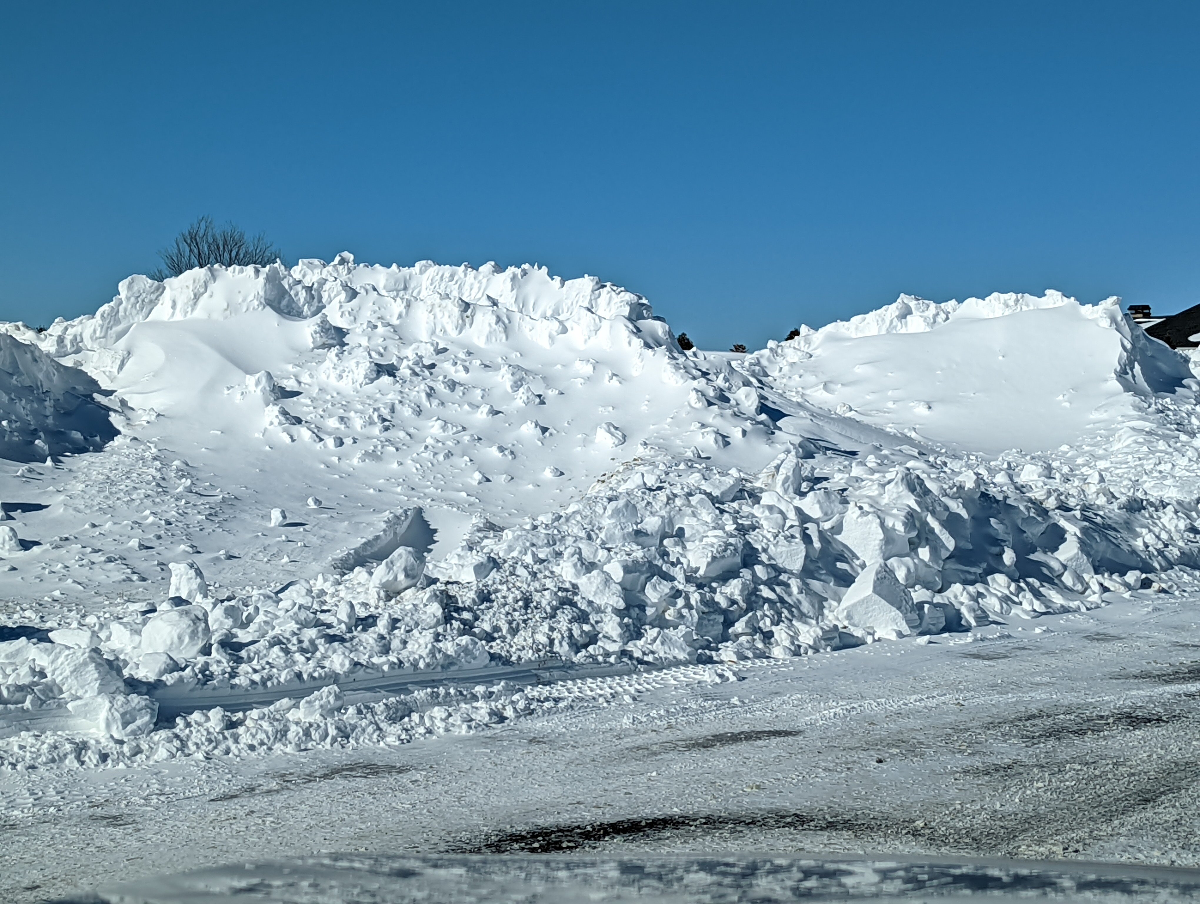
I'm guessing in a storm like this, under-reporting might be a bigger risk than inflated totals? (Assuming folks stay away from obvious drifting areas)
-
3
-
-
6 minutes ago, JC-CT said:
that was quite the interesting weenie band that just hung out over your way
Yes... It had looked for a couple of days like there would be a secondary band further west; I really didn't get into the best part of it. I think srn Hartford, eastern New Haven and Middlesex County had much better rates than I did. The eastern CT band was the sweet spot for CT. Horrible storm to try to measure snow totals, wind and shredded flakes? My guess we are going to see if lots of under reporting due to conditions.
-
1
-


March 9: Little Critter that could part 2.
in New England
Posted
Not what I was hoping for???