

FXWX
-
Posts
834 -
Joined
-
Last visited
Content Type
Profiles
Blogs
Forums
American Weather
Media Demo
Store
Gallery
Posts posted by FXWX
-
-
56 minutes ago, Ginx snewx said:
Some of the discussions in here have me baffled. I mean in recent ( under 5 years) we have had serious rain to snow storms in March, multiple rain to snow Anafrontal accumulating snow storms. If the lift is there it will bomb snow. I also read in an AFD about the roads being too warm to accumulate. Its baffling
The road temp question is always misrepresented and not assessed correctly by many... rates always win-out. Even last night with glorified snow showers and patchy areas of steady light snow we had to send out trucks to treat high elevation roads here in Burlington, as solid coating occurred. The potential for big rates easily out-weighs any road temp concerns...
-
35 minutes ago, Ginx snewx said:
Enjoy
.thumb.png.f0c99ce36e41696d562b3b1dd84cc8a0.png)
For a few days now, the global schemes have all shown the likelihood of surge of bitter cold moving into southeastern Canada during early March. It is not hard to envision a intensifying Maritimes low combining with a sharpening trough sweeping across southeastern Canada driving a piece of the bitter air mass south into New England. Whether or not the pattern across southeastern CT and the Maritimes allows it to happen is very uncertain. Obviously at this time frame, you bet against it. But I think there is a good chance a bitter cold air mass will indeed move into southeastern Canada. Whether or not it can be propelled southward into New England is an open question. But I certainly would not dismiss it; especially for portions of Northern New England.
-
2 hours ago, The 4 Seasons said:
perfect. thank you.
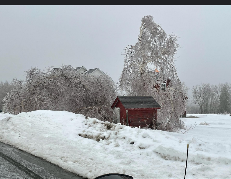
3.0" in Burlington at 1,140 ft... Had 2 pic (rule measurements) sent to me from Highland Lake area of Winsted showing 4.5"
-
 2
2
-
-
5 minutes ago, CoastalWx said:
Looks good for the hills by DXR.
The ridgeline from New Canaan to Ridgefield to Danbury getting smoked...
-
16 minutes ago, Sey-Mour Snow said:
Yes seems the colder trends coincide with faster arrival of precip which doesn’t allow surface to warm as much. SPC mesoanalysis surface wet bulb is very cold still.
It also puts the brakes on the warming taking temps down a notch or two once it sets in...
-
16 minutes ago, Sey-Mour Snow said:
Well then .. 12 HRRR.. Most mets would hope thats wrong in CT .. Although the inner snow lover would love to see that happen.. 2" per hour for 1-3 hours across much of CT as heavy snow causes dynamical cooling.
That would blast the lower Fairfield County forecast right out of the water...
-
36 minutes ago, Damage In Tolland said:
Man.. it’s legit S+. May get to 4”
New 1.2 since 5 pm; just touched 4" mark
-
1
-
-
Just now, DotRat_Wx said:
Hearing some CT towns thrown off by early coating
Yes... towns that did not pretreat and/or DPW crews were not ready to go; especially across northwestern areas of CT, need time for a full treatment, which takes early dismissals off the table... switched to remote learning day. Many towns were ready to treat and are fine...
-
24 minutes ago, Ginx snewx said:
Damn, radial?
~0.4"
-
Burlington, CT... 1,160'
-
5
-
-
1 minute ago, moneypitmike said:
My daughter goes to school in Marion--immediately off the Cape. I just texted her to enjoy her snowstorm. I hope I didn't jinx her!
Rates should overcome low-level warmth... they will waste a bit of qpf, but I would still expect them to verify moderate totals at least.
-
1
-
-
16 minutes ago, Ginx snewx said:
Graf

Steve, what's the url for that site?
-
1
-
-
12 minutes ago, CT Rain said:
700mb track on euro definitely pretty funky. Brings it all the way west into C NJ
Certainly weird looking... lots issues to still be resolved that will greatly impact final totals...
-
1 hour ago, Typhoon Tip said:
I have been wondering about this and I "think" I have a plausible explanation why we are seeing these aggregated clusterings of QPF showing up in some of the recent guidances, packed within 50 miles of coasts N of NJ -
I'm noticing as we are nearing the neared side of the mid range and about to relay off to the outer range of the short range ( ...phew, hate those kind of sentences ), the models are getting interestingly quite cold in the BL at all the major hubs, PHL-NYC-BOS-PWM.. I think we may be getting a bit of long-fetch immediate coastal lift over CF effects there - I am not sure even the depictions of the higher resolution Euro species would really be illustrating that in the l-level discreteness ... but it might be there embedded in the on-going din of everything that's going on in the model physics.
I just think with that deep longitudnal flow coming in normal to what is getting colder and colder in the guidance, there's likely to be some interesting QPF issues on the flop ( west) sides of those interfaces..
And I also wonder if said processing in the models may even be doing too much - as in over compensating for that interface. This could be causing some QPF shadowing to get exaggerated out in western zones where there's orographic effects then compounding.
Very much agree with those thoughts... I think yesterday you mentioned looking at the crude E-Wall site Euro maps. I often use that site as a simple overview of the large-scale features and what they imply before I dig deeper with the more "sophisticated" model sites.
-
2 hours ago, Damage In Tolland said:
Hey John! Yes.. thank you for chiming in here. We’ve been trying to explain that to weenies calling for an inch in CT and a foot in E MA. Qpf is tossed. It’s crushjob . They don’t look outside the box
Actually, many times I think there is just too much data (maps) to look at; sometimes its best to pull out the Kocin book and look at similar 500/700/850 setups and check out qpf distribution. Even just looking at the crude E-Wall euro map is a great starting point to look at the overall pattern...
-
3
-
-
2 hours ago, 40/70 Benchmark said:
Outside of the valleys, yes...
Yep... always some valley shadowing with this type of flow; extent and degree debatable... I'm never great on the valley amounts call; have busted both ways...
-
I rarely post, but thought I will throw my 2-cents in for the Monday / Tuesday event. I would run with an earlier onset for SNE based on my experience with these setups. Secondly, at this point in time, I would toss or at least not focus too closely on the modeled qpf maps right now; not only the snowfall junk maps; take qpf maps and put them aside for now. If the large scale Euro features end-up close to verifying; higher qpf amounts will verify further west than now modeled. Those 700 & 850 depictions and inflows are not going to keep big totals pinned across eastern SNE; 700 & 850 inflows certainly suggest to me that you should not under-play heavy totals pushing further into western CT & southeastern NY.
-
5
-
 1
1
-
 1
1
-
-
22 hours ago, powderfreak said:
Who is John Bagioni? lol.
Me! A private met, who's usually flies under the radar and rarely post here... Will occasionally tweet, but not a lot; last night's response to Kev's tweet, which I obviously misinterpreted, led to a bit of back and forth and inspired a mention about who I am on here, so thought i would fill in the blanks. Snow and/or rain totals from Burlington, CT (BOX PNS products) are usually mine. We are building a new house on the highest elevation lot in Hartford County (~1150 feet) and I will likely post more given the snow & wind gust climatology of that area. I've been a consulting met for almost 40 years and my company name is Fax-Alert Weather Service. Started company when fax machines were just becoming common in businesses and it was the primary mode used to transmit updates and alerts to my clients. Company name (Fax-Alert Weather) was based on mode of communication to clients at the time I started business. That mode of contact ended when email, text alerts and web services became the normal, but I kept the name since I had no desire to change business registration, IRS filings and the name recognition with all my clients. Currently, consult with 85 CT/NY school districts, several town DPW operations, snow removal and landscaping businesses, as well as 4 Energy Associations (Oil / Propane dealers), Wachusett's Ski Resort and Aubuchon Hardware Company. Also, deal with numerous insurance companies and law firms for forensic services. Check in occasionally to see what some mets one here (ORH, Coastal, Tip, Ryan H, OceanStWx to name a few) are thinking; also great to see younger generation guys like Wiz getting more involved and more experienced. Find inputs from others like Ginx, 40/70, yourself, and yes, even Kevin, worthy of following. Know Ryan H well and consider Ryan and Bob Maxon the best media duo in CT; the viewing public in CT is blessed to have them on air; especially during severe t-storm outbreaks... Also, nice to see my good friend Walt Drag posting more and more; about as good as it gets. Been around long enough that nothing really surprises me anymore; be it balmy Xmas periods, miserable springs or dud severe weather seasons... looks like I've more than answers the who is …. question, lol, but just in case I piss someone off again, everyone will know who I am... Stay safe and have a wonderful holiday season; don't worry about the snow pack; more is a-coming!!!
-
23
-
3
-
-
3 hours ago, weatherwiz said:
yeah I was just checking the 18z HRRR and it had 60-80 J of 3km CAPE...given the shear parameters that certainly may be enough.
Maybe I'm wrong and there will actually be some convection involved here. I think that's really the only way we materialize higher end winds out of this. Even still looking at bufkit (only looked at CT) it still seems to be struggling to really bring down significant gusts. But I mean if there is convection involved...it's going to be quite ugly. I just didn't see much in the way for convection outside of the insane forcing.
EDIT: actually 12z was a bit better at BDL in terms of mixing
The thing I would be wary of is assuming the modeling (bufkit) is 100% correct in terms of mixing? Plus in these types of only hint of convective elements would be needed to generate big issues; especially for eastern CT...
-
1
-
-
45 minutes ago, Ginx snewx said:
Dumb ass read what they wrote above
You mean folks are supposed to read and assess scientific reasoning and not just look at the pretty pictures? That would take too much time; lol
-
9 minutes ago, HoarfrostHubb said:
Any idea what is causing this radar return in CT?

Gravity waves...
-
2
-
-
13 minutes ago, WinterWolf said:
No my town will cancel and no remote learning if/when they do. They purposely made that clear here. Smart move imo. Let the kids be kids for god sakes.
Just realized what you meant...and I agree 100%.
Many towns will continue with normal snow days and then adjust if snow day needs get too great; also for a 2-day event many will do a snow day for day 1 and then remote learning for day 2.
-
Just now, powderfreak said:
Ha I honestly wanted to use the graphics to illustrate something to a friend. Figured they ran from like BGM to Dendy.
http://moe.met.fsu.edu/banding/
-
1
-
-
On 12/5/2020 at 5:34 PM, dryslot said:
I had it made.
Nice... I like the look and style... Nothing online the looks anywhere near as nice...
-
1
-
.png.07194c882abd807239aa719cf88f700c.png)


May 2021 Discussion
in New England
Posted
Normal is low 70's...