

FXWX
-
Posts
834 -
Joined
-
Last visited
Content Type
Profiles
Blogs
Forums
American Weather
Media Demo
Store
Gallery
Posts posted by FXWX
-
-
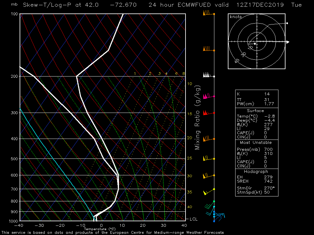
BDL coarse sounding from 12z Euro; valid 12z Tuesday...

-
 1
1
-
-
30 minutes ago, The 4 Seasons said:
that would be nice. I'm making a map right now, actually 2, one for ice one for snow. Leaning heavily on the ECMWF/NAM/Canadian, disregarding the GFS. My biggest challenge right now i feel is the immediate shore and whether they flip over to rain or get prolonged icing. Past experience tells me BDR/HVN/GON should pop above 32 into the mid 30s
I forsee widespread closures for most of the state due to icing, with the exception of the immediate shore may just have delays or nothing at all, unless it ends up being much colder there.
No disagreement with that... Ongoing winter precipitation events are almost always a cancellation, given desire of bus companies to stay off the roads when precip is still ongoing and opposition from DPW folks who do not like to have their trucks actively treating or scraping with kids standing along the sides of roads or at street corners...
-
1
-
-
16 minutes ago, Nikoss427 said:
When are we expecting this to start, Monday night or more towards Tuesday morning. I'm hoping we can squeek out an early dismissal Tuesday by starting this later. We're already up to 3 snow days in my district.
The early dismissal option is the only option that is not on the table. Late openings Tuesday or cancellations are the 2 most likely outcomes... Early dismissals are in play when an event is arriving during the afternoon, not when it starts the night before or during the predawn hours.
-
1 hour ago, The 4 Seasons said:
Some totals so far.

4.5 in Burlington
-
Just broke the 4" depth here in Burlington...
-
1.7" here in Burlington; mod/hvy; 32
-
2 minutes ago, It's Always Sunny said:
I still have yet to find a website (including paid) that provides ECMWF soundings. If anyone knows of them please let me know. In the meantime I usually have to have 6 windows open with different variables displayed to paint a picture so to speak.
AccuWx Pro
-
2
-
-
17 minutes ago, dryslot said:
Don't think many models were able to nail done those bands, But i wasn't paying much attention.
The lesson that you take away from this system, and it is a lesson that has to be constantly harped about, is that modeling will more often than not do poorly on the placement of these meso bands. They will show you the well known pattern features that imply significant banding should occur, but they will struggle or just completely fail on getting the location and often the intensity of the banding correct. The upper air components were screaming banding for days with this setup and folks were living and dying each model run on where the banding was being depicted by admiring qpf or clown snowfall projection maps. In the end, the take-away is use the modeled 500/700/850 forecast tracks & configuration to forecast the likelihood of banding but only give general hints at where it might end up. Then it becomes a nowcast deal as the banding starts to tip its hand; late yesterday afternoon and very early in the evening, nowcasting using mainly the SPC meso analysis page you could see how and where the banding was going to setup. I expect the models to miss the banding location(s) more times than not; we have seen it numerous times over the years. With this system most if not all of the primary models were screaming banding if you looked at the 500/700/850 forecasts. But it almost always comes down to nowcasting for the final outcome.
-
3 minutes ago, 40/70 Benchmark said:
Pretty good, but not done yet.
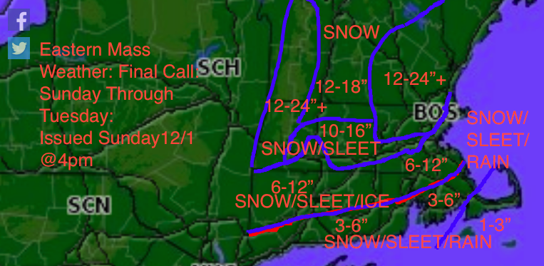

Map does not accurately depict totals across western Hartford County and eastern Litchfield County; I had 15 total in Burlington (western Hartford Cty and Harwinton in eastern Litchfield Cty has 14"... BOX has not updated my total...
-
1
-
-
11.5 new in Burlington; total 15"
-
11.5 new during evening / overnight period here in Burlington, CT... storm total 15.0 inches
-
1
-
 1
1
-
-
48 minutes ago, CT Rain said:
The people skewering us saying the storm was a bust even though they got 2" of snow and going to get some more tonight is hilarious.
We also had a 5"-10" band within 5 miles of the Mass border in N CT that worked out well and a 10"+ in far northern Litchfield Co. Overall... from timing to amounts it worked out fine. People are just nasty and miserable.
This "People are just nasty and miserable!" Been my philosophy for years; lol
-
2 hours ago, Damage In Tolland said:
Odds of a ratter seem 50/50. Lots of good mets are nervous about it
Can you name a few of the "lots" of good mets that are worried about a ratter?
-
1 hour ago, weatherwiz said:
ohh...I know that

but i meant how to physically add a location.
Like Steve had a white dot that said Castle de Ginx
A friend at school also has a white marker labeled WCSU.
Go to your menu; top left (3 bars) then go to radars and locations.. go to locations tap, upper right. At the bottom go to add a location. You can put exact location in, street number, etc. save and it will show it on the radar. Then go back in and you can edit it to show only a symbol or a short name.
-
1
-
-
13 minutes ago, powderfreak said:
I’ve only had a handful in my life but it also starts with the visual aura... I’d never wish that on my worst enemy. I just remember laying in a dark room for like 4 hours just wanting it to be done. Props to you guys that deal with that shit more regularly.
Had them on a regular basis through my 20's and 30's. No medication made much difference. For whatever reason the thing that eventually worked, is as soon as I noted the hint of the visual aura, I would down a coke (not diet) and 4 Advil's. If I migraine came on after that it was mild and short-lived. I have no idea why it worked...
-
1
-
-
1 hour ago, dendrite said:
Congrats
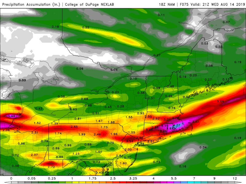
I have not been able to get into DuPage web site for 2 days? Have they changed their url?
-
1
-
-
46 minutes ago, weatherwiz said:

Crap! I'm still cleaning up from the Worcester redo tornado event of last week!!!
-
 2
2
-
-
On 5/11/2019 at 11:55 AM, dendrite said:
Love them. The only ones I may love more are indigo buntings.
Lots of activity this morning...orioles, rose breasted grosbeaks, hummers, catbirds, finches, etc. The only elusive feeder bird for me has been bluebirds.
Have bluebirds at my feeders; they like the mealworms (dead) that Lowes sells locally down here. First pair of nesting bluebirds in our yard has fledglings that are already sticking there heads out of the box. This brood will likely be on their own within another week or 10 days... Usually they will start another brood by mid-June.
-
2 hours ago, Damage In Tolland said:
April was AN

Do you have the url link to this graphic?
-
16 minutes ago, CT Rain said:
Just a sick fire hose coming in too. Going to puke rain tonight.
Will have to watch some areas for a dynamic flip tomorrow morning.
Such a volatile situation; hard to quantify and plan for what a flip would look like, if it happened at all and how it might impact conditions across northern CT; could run the gamut of impacts from zero issues to surprise slushy travel; if dynamic flip occurs across northern CT, what would you estimate the best timing??? thinking somewhere in 4:30 - 7:30 am period?
-
1 hour ago, CT Rain said:
Let's do this
No disagreement from me... just happy it will be a Saturday morning issue, not work/school day, in the high terrain areas of CT school Regions 1 & 7 districts...
-
36 minutes ago, 40/70 Benchmark said:
People just can't wrap their minds around how perilously close it is to a big hit. I agree that it probably isn't happening, but that isn't the point.
Count not agree with you more. Folks instantly make a jump to "there is no way this is happening or show me a model that calls for a region-wide blizzard" when the statement is just about how meteorologically close this is to a remember-able bomb event! Will it happen, probably not and yes eastern areas are closer to trouble than western areas, but the atmospheric setup is only a hair off from being a truly wild event. Again, I am not calling for it, but I can certainly appreciate the closeness of the pattern to a nasty event.
-
1
-
-
Just now, Typhoon Tip said:
Oh we wouldn't be expressing any consternation over what's going to happen at 130 hours if that were the case - we'd be counting up SNE's corrected season snow deficits
No doubt! As much as I am ready for spring, that type of setup with the potency of the upper dynamics & the nature of that air mass would have me saying, "ok, lets go out with a true bang!"
-
13 minutes ago, Typhoon Tip said:
They seem to be stabbing cold shots that roll out quick if one uses the Euro...
Like the first rolls out in 24 hours ...raising regional 850s from some -15 C day six, all the way to + 2 by the beginning of day seven... and with west wind in that look it's headed for the mid to high 60s. I've actually seen that look in the autumn before ironically -
Yep; angle of attack into southeast Canada and the westerly component does indeed suggest it will not hang around; big 24-hour flip if the cold does make it into parts of nrn New England; particularly Maine. Would be more interesting if the modeled flow was displaced ~300-500 miles to the west?
Jan 8th, 2020 Coastal - little critter
in New England
Posted
Is your actual ob or something that was passed along? I cannot find an airport visibility ob or a highway camera showing anything approaching moderate snowfall rates? I-84 / I-95 cams showing very decent visibility?