

FXWX
-
Posts
838 -
Joined
-
Last visited
Content Type
Profiles
Blogs
Forums
American Weather
Media Demo
Store
Gallery
Posts posted by FXWX
-
-
17 minutes ago, ORH_wxman said:
GFS still going with FROPA next Friday. That would be ideal for the ski resorts and specifically the event at Killington next weekend.
Given the very good snow making temperatures, in general, they would actually prefer a frontal passage with a mainly dry weekend...
-
Heavy sleet in Burlington, CT... Actually quite impressive...
-
 4
4
-
-
Snow flying in Burlington, CT
-
2
-
 1
1
-
-
3 hours ago, CoastalWx said:
Where does Kevin find this shit?
The Dark Web!
-
 3
3
-
 1
1
-
-
Note there is no quantification of what "winter weather" risk entails... Is it a coating, a couple of inches, a foot of snow??? Or is just some flakes in the air a a few pellets bouncing around? Meaningless graphic in me eyes...
-
1
-
2
-
1
-
-
8 hours ago, CoastalWx said:
While I agreed with general timing of the pattern transition, also thought it would likely trend later as we got closer. That is obviously not the case. The one caution I would urge though is be wary of how firmly New England gets into the solidly colder than normal zone. It is very common during La Niña events for the core of the cold be anchored well west of New England. The euro ens (above) and other products clearly show this tendency. While sitting on the eastern edge of the cold shield could allow for an active start to the winter storm season for us, it could limit our early season snow potential, as favored storm track could be through or west of New England??? Just a thought… I’d like to see the core of the cold anomaly positioned over the Midwest / Great Lakes region.
-
2 hours ago, CoastalWx said:
50mb is closer to the troposphere, and would likely have a better chance of propagating down to the troposphere. I can post 10mb too. I never look at 10mb to be honest because you can have the moon collapse and blow up there and nothing propagates down lol.
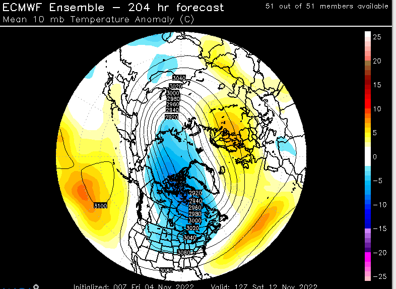
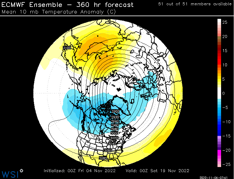
Might be my favorite quote ever about using 10 mb level... Lol... Actually put a smile on my face...
-
1
-
-
4 minutes ago, CoastalWx said:
Don't forget the drooling over deformation band placements.
Yes... And I'm sure we are leaving out several other favorite bones to pick...
-
8 minutes ago, CoastalWx said:
This is pants tent stuff if this were 6 weeks from now lol. For an ensemble mean that far out, pretty sweet look. We Miller B.
Then we would have to listen to 9 days complaints about whether or not the high would slip offshore to early, or block the northward push of moisture into nrn New Eng, as well as where the coastal front will setup; screw zones... etc... My head hurts just thinking about it!!! Lol
-
6
-
-
33 minutes ago, WinterWolf said:
Just too dam sad some peeps feel the need to cancel things…downright pathetic.
I still hear warm fall periods referred to as Indian Summer by mets... I use all the time during warm fall periods in my daily updates to my clients... Have never been approached about it having a negative connotation. You might be confusing the Columbus Day issue, which has been a sticking point in some areas given Columbus writings stating his thoughts about indians being the perfect slave, and/or being easily slaughtered.
Getting back to Indian Summer, the research I've seen references the fact the local natives indicated to settlers that there was time for more harvesting after the initial cold of early fall since it was often followed by a warm period(s); thus Indian Summer. Indians were aware of this tendency to see warm periods after early fall cold.
-
4
-
-
3 minutes ago, HoarfrostHubb said:
I do love it on my phone. Is there a computer version?
On a large computer screen (laptop or desktop) it's tremendous...
-
1
-
-
1 minute ago, HoarfrostHubb said:
I do love it on my phone. Is there a computer version?
Yes
-
2 hours ago, 40/70 Benchmark said:
Unfortunately, do you want to know what the real travesty is? This is probably the more profitable avenue for him at this point, since he had established a reputation as a prominent contributor in the field, he has a platform and can use the sensationalism as a vehicle for a tremendous volume of "click", which generates massive income.
If you have ever read the book on the Red Sox "Feeding the Monster", this is the equivalent of that within the meteorological industry.
Absolutely no argument from me! Not looking to get into all the well known specifics, but it is flourishing in many industries; public and private. It is all about maintaining a revenue stream regardless of truth or facts...
-
1
-
1
-
-
2 hours ago, 40/70 Benchmark said:
Its a shame what he has become with the rise of the internet.....he was at the top of the industry 20 years ago.
Agree 100%... He just moves on from one failed hype to the next... very predictable scenario... every year there is at least 1, if not multiple mentions of Hazel, the 38 storm and other historic events. Compared to a decade or 2 ago, his credibility is shot...
-
1
-
-
3 hours ago, SJonesWX said:
what a joke. anything to get clicks.
Don't worry some storm will form and miss by 1000 miles but he will use it to say "see my forecast had merit"....he is far more predictable than any hurricane.
-
3
-
1
-
-
2 minutes ago, Damage In Tolland said:
Wasn’t it supposed to be a harsh cold shot in SNE Friday with 50’s by day and freeze at night? Ryan has 66/44 for Friday
Nobody had freezes across CT Friday; there will be upper 50's for highs across most of elevated CT... Ryan's number likely reflects the highs for metro areas as well as I-91 corridor...
-
3
-
-
1 hour ago, wdrag said:
No answer to the Monday 8/29 post. Glad to see there is interest. Sometimes the pattern changes abruptly (witness Dallas a week ago with
1 foot+ after months of nothing).
I'm seeing via the 12z/1 ensembles a suggestion of a fairly large closed low developing next week either mid Atlantic or near the Ohio Valley.
I am confident it will happen but unsure whether we are initially targeted widespread 3 day 2"+ Sun-Tue night, or whether need to wait til next weekend
for flooding rains somewhere Ohio Valley to the mid Mid Atlantic. Worthy of monitoring trends every 24 hours.
For now: I wait, fingers crossed that the ensembles will continue drifting to a big closed low and am hoping that it will be affecting our area with widespread 2+.
I don't operate on hope and continue using water judiciously so the pool water keeps the skimmers going and some of the flowers blooming. Forget the lawn.
Will run with 24 hour trends on this...
Hey Walt my interest has certainly risen over the past 24 hrs for potential big totals across SNE... Hedging closer to Tue/Wed, but not trying to get too specific right now. Several overlapping, relatively weak features at the moment that in the past were tip offs to a big rain event. Been waiting for the great flip from drought to an excessive rain event to show itself. Will be interesting to see overnight trends...
-
3
-
-
29 minutes ago, Torch Tiger said:
September but ...

As depicted, that would be a fish storm...
-
 1
1
-
-
1 hour ago, Typhoon Tip said:
HFD is 88 with a W wind. Boston is 70 with an E
Tip... When you have a second, check your messages.
-
52 minutes ago, Ginx snewx said:
I can see a big pattern change mid month. More of a Bermuda high moist muggy but cooler cloudy regime. Maybe some Bermuda blues days but all eyes on the tropics. Should be an interesting second half as we break the droughts back.
Agree... Also think the long slog back towards more frequent widespread rain events for SNE... It wouldn't be a flip the switch pattern change to a wetter pattern, but I'm encouraged by what I see in terms of rainfall trends down the road.
-
3
-
-
30 minutes ago, weatherwiz said:
It was also in a really tough radar spot.
we need radar back at BDL!!!!!
Looking back at the velocity scans, I doubt there are many NWS forecasters that would have warned on that cell. I think calling it more of a landspout is correct; probably helped along by just enough terrain induced rotation.
-
1
-
-
22 minutes ago, weatherwiz said:
Clouds and the developing area of rain really killing things...then we have that cluster that developed in northwest New Jersey which will be moving into western Connecticut within a few hours. It's a nice looking cluster with tons of lightning) but it's probably at it's maximum intensity. Maybe some localized influences can work to tighten any rotation but the clouds/precip are yielding really crappy low-level lapse rates. Steeper low-level lapse rates would have gone a long way in additional parcel acceleration and yielded better (not necessarily in terms of numbers) low-level CAPE...better in the sense of it could be utilized more efficiently to assist with tightening couplets.
It's almost impossible in these types of flows to get abundant sunshine across SNE... Cloud cover is usually fairly widespread. That being said, nature of the atmosphere is still decent for some severe events from northern NJ northeast into southwest CT. SPC meso analysis is highlighting southeastern NY into southwest CT for an elevated spin-up risk over the next couple of hours. Given low lcl's I would closely monitor any organized cells moving across that area? Could see a non-warned event or a late warned event.
-
1
-
1
-
-
52 minutes ago, Typhoon Tip said:
Which run did you have in mind - like,... which specific run cycle.
The 00z and 06z look nothing like in the 15th to 25th.
Secondly,no one should using a model as a "snapshot" - ... I mean obviously...
Look, this isn't an engagement that has anything to do with Meteorology and everything to do with f'n around. You've been instructed, both kindly and condescendingly ( because folks are at a loss), and being an intelligent guy yet impenetrable to logic and propriety ... it is clear there is no interest in Meteorology. I am officially wasting my time typing and will now stop - LOL
continue to have fun. Life is short

"it is clear there is no interest in Meteorology"
Truer words have never been spoken!!!
-
1
-
-
2 minutes ago, weatherwiz said:
Drought and New England should never be used in the same sentence. These "drought monitor" charts are brutal. There is a difference between drought and dry soils.
Absolutely correct Wiz... One of the most useless discussions in New England weather forum is the drought, endless Stein chatter. Lack of exciting severe wx or hurricane threats or truly hot periods pushes folks to spend endless time on New England faux drought crap.
-
7
-
2
-
2
-

November 2022 OBS/DISC
in New England
Posted
My message to the energy groups I deal with has been the following: the cold second half of Nov. would moderate at month's end and early December would see the continuation of the moderating trend, but not a blow torch pattern like some of the most recent Decembers. While the Pacific will go through an ugly look for a bit during early December, I think some weak to moderate -NAO, or just some higher than normal heights across NAO sector will help keep Northeast moderation during early December in check; moderation yes; extended torch no; at least not on the scale of some recent Decembers. I think the pattern post from about December 10th onward to trend at least normal with the door opening back up for at least periods of somewhat colder than normal conditions. Right now, I think hype about December being lost are way off base. It may not be a December of yore, but second half will be decent, just not historic...