WxWatcher007
-
Posts
35,670 -
Joined
-
Last visited
Content Type
Profiles
Blogs
Forums
American Weather
Media Demo
Store
Gallery
Everything posted by WxWatcher007
-

Major Hurricane Melissa - 892mb - 185mph Jamaica landfall
WxWatcher007 replied to GaWx's topic in Tropical Headquarters
2:00 AM EDT Tue Oct 28Location: 16.8°N 78.4°WMoving: NNE at 2 mphMin pressure: 901 mbMax sustained: 175 mph -
Major Hurricane Melissa - 892mb - 185mph Jamaica landfall
WxWatcher007 replied to GaWx's topic in Tropical Headquarters
Likely the last VDM of the night. The eye size has been remarkably consistent. Product: Air Force Vortex Message (URNT12 KNHC)Transmitted: 28th day of the month at 5:02ZAgency: United States Air ForceAircraft: Lockheed WC-130J Hercules with reg. number AF96-5301Storm Name: MelissaStorm Number & Year: 13 in 2025 (flight in the North Atlantic basin)Mission Number: 22Observation Number: 36 ( See all messages of this type for this mission. )A. Time of Center Fix: 28th day of the month at 4:36:00ZB. Center Fix Coordinates: 16.73N 78.49WB. Center Fix Location: 142 statute miles (229 km) to the SW (231°) from Kingston, Jamaica.C. Minimum Height at Standard Level: 2,236m (7,336ft) at 700mbD. Minimum Sea Level Pressure: 903mb (26.67 inHg)E. Dropsonde Surface Wind at Center: From 185° at 11kts (From the S at 13mph)F. Eye Character: ClosedG. Eye Shape & Diameter: Circular with a diameter of 10 nautical miles (12 statute miles)H. Estimated (by SFMR or visually) Maximum Surface Wind Inbound: 156kts (179.5mph)I. Location & Time of the Estimated Maximum Surface Wind Inbound: 4 nautical miles to the N (8°) of center fix at 4:34:30ZJ. Maximum Flight Level Wind Inbound: From 99° at 149kts (From the E at 171.5mph)K. Location & Time of the Maximum Flight Level Wind Inbound: 5 nautical miles to the N (6°) of center fix at 4:34:00ZL. Estimated (by SFMR or visually) Maximum Surface Wind Outbound: 157kts (180.7mph)M. Location & Time of the Estimated Maximum Surface Wind Outbound: 6 nautical miles to the SSE (150°) of center fix at 4:38:00ZN. Maximum Flight Level Wind Outbound: From 242° at 162kts (From the WSW at 186.4mph)O. Location & Time of the Maximum Flight Level Wind Outbound: 6 nautical miles to the SSE (150°) of center fix at 4:38:00ZP. Maximum Flight Level Temp & Pressure Altitude Outside Eye: 12°C (54°F) at a pressure alt. of 3,054m (10,020ft)Q. Maximum Flight Level Temp & Pressure Altitude Inside Eye: 23°C (73°F) at a pressure alt. of 3,058m (10,033ft)R. Dewpoint Temp (collected at same location as temp inside eye): 12°C (54°F)R. Sea Surface Temp (collected at same location as temp inside eye): Not AvailableS. Fix Determined By: Penetration, Radar, Wind, Pressure and TemperatureS. Fix Level: 700mbT. Navigational Fix Accuracy: 0.02 nautical milesT. Meteorological Accuracy: 1 nautical mileRemarks Section: Maximum Flight Level Wind: 165kts (~ 189.9mph) which was observed 7 nautical miles to the ENE (58°) from the flight level center at 3:47:00Z -
Major Hurricane Melissa - 892mb - 185mph Jamaica landfall
WxWatcher007 replied to GaWx's topic in Tropical Headquarters
Thought it had a chance but I guess it leveled out. -
Major Hurricane Melissa - 892mb - 185mph Jamaica landfall
WxWatcher007 replied to GaWx's topic in Tropical Headquarters
Agree. Probably somewhere between 898-901mb and 155-160kt. Really glad they're going in for another pass. -
Major Hurricane Melissa - 892mb - 185mph Jamaica landfall
WxWatcher007 replied to GaWx's topic in Tropical Headquarters
Not sure off the top of my head. -
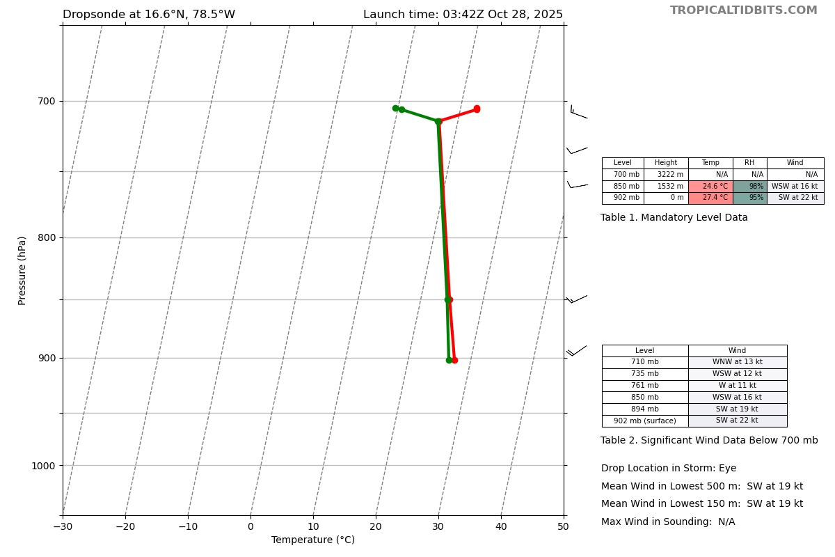
Major Hurricane Melissa - 892mb - 185mph Jamaica landfall
WxWatcher007 replied to GaWx's topic in Tropical Headquarters
Product: Air Force Vortex Message (URNT12 KNHC)Transmitted: 28th day of the month at 4:06ZAgency: United States Air ForceAircraft: Lockheed WC-130J Hercules with reg. number AF96-5301Storm Name: MelissaStorm Number & Year: 13 in 2025 (flight in the North Atlantic basin)Mission Number: 22Observation Number: 28 ( See all messages of this type for this mission. )A. Time of Center Fix: 28th day of the month at 3:42:00ZB. Center Fix Coordinates: 16.65N 78.52WB. Center Fix Location: 147 statute miles (237 km) to the SW (230°) from Kingston, Jamaica.C. Minimum Height at Standard Level: 2,247m (7,372ft) at 700mbD. Minimum Sea Level Pressure: 902mb (26.64 inHg)E. Dropsonde Surface Wind at Center: From 220° at 22kts (From the SW at 25mph)F. Eye Character: ClosedG. Eye Shape & Diameter: Circular with a diameter of 10 nautical miles (12 statute miles)H. Estimated (by SFMR or visually) Maximum Surface Wind Inbound: 164kts (188.7mph)I. Location & Time of the Estimated Maximum Surface Wind Inbound: 3 nautical miles to the N (4°) of center fix at 3:40:30ZJ. Maximum Flight Level Wind Inbound: From 97° at 152kts (From the E at 174.9mph)K. Location & Time of the Maximum Flight Level Wind Inbound: 4 nautical miles to the N (4°) of center fix at 3:40:00ZL. Estimated (by SFMR or visually) Maximum Surface Wind Outbound: 160kts (184.1mph)M. Location & Time of the Estimated Maximum Surface Wind Outbound: 6 nautical miles to the ENE (58°) of center fix at 3:46:30ZN. Maximum Flight Level Wind Outbound: From 154° at 165kts (From the SSE at 189.9mph)O. Location & Time of the Maximum Flight Level Wind Outbound: 7 nautical miles to the ENE (58°) of center fix at 3:47:00ZP. Maximum Flight Level Temp & Pressure Altitude Outside Eye: 10°C (50°F) at a pressure alt. of 3,052m (10,013ft)Q. Maximum Flight Level Temp & Pressure Altitude Inside Eye: 22°C (72°F) at a pressure alt. of 3,049m (10,003ft)R. Dewpoint Temp (collected at same location as temp inside eye): 14°C (57°F)R. Sea Surface Temp (collected at same location as temp inside eye): Not AvailableS. Fix Determined By: Penetration, Radar, Wind, Pressure and TemperatureS. Fix Level: 700mbT. Navigational Fix Accuracy: 0.02 nautical milesT. Meteorological Accuracy: 1 nautical mileRemarks Section: Maximum Flight Level Wind: 165kts (~ 189.9mph) which was observed 7 nautical miles to the ENE (58°) from the flight level center at 3:47:00Z -
Major Hurricane Melissa - 892mb - 185mph Jamaica landfall
WxWatcher007 replied to GaWx's topic in Tropical Headquarters
That was a big time dropsonde in the NE eyewall. Given the pressure falls and FL wind this is probably stronger than the current advisory. -
Major Hurricane Melissa - 892mb - 185mph Jamaica landfall
WxWatcher007 replied to GaWx's topic in Tropical Headquarters
Latest sonde: 902mb w/ 22kt wind. Melissa is on the cusp of going sub 900mb. -
Major Hurricane Melissa - 892mb - 185mph Jamaica landfall
WxWatcher007 replied to GaWx's topic in Tropical Headquarters
For us old timers -
Major Hurricane Melissa - 892mb - 185mph Jamaica landfall
WxWatcher007 replied to GaWx's topic in Tropical Headquarters
Hurricane Melissa Discussion Number 27 NWS National Hurricane Center Miami FL AL132025 1100 PM EDT Mon Oct 27 2025 Both Air Force and NOAA Hurricane Hunter aircraft have been investigating Melissa this evening. They found that the system is maintaining category 5 intensity with the central pressure near 903 mb and peak 700 mb flight-level and tail Doppler radar winds supporting 150 kt for the current intensity. The hurricane continues to exhibit a well-defined eye about 10 n mi in diameter embedded within extremely cold cloud tops to near -90 deg C. Upper-level outflow remains well defined over the system. Although such intense tropical cyclones typically undergo an eyewall replacement, radar observations from Jamaica do not show this occurring thus far. After remaining nearly stationary over the past few hours, Melissa now appears to be moving slowly north-northeastward with an initial motion estimate of around 020/02 kt. During the next few days, a mid-tropospheric trough is forecast to deepen near the southeastern U.S. coast. This should result in Melissa moving north-northeastward to northeastward with increasing forward speed through the forecast period. The official forecast is similar to the previous one and also close the tightly-clustered consensus and Google DeepMind guidance. The only significant difference in the track forecast compared to earlier today is a slower motion during the first couple of days, which delays the expected arrival of the core of Melissa over Jamaica, eastern Cuba, and the southeastern or Central Bahamas. Some fluctuations in intensity could still occur during the short period before Melissa reaches Jamaica. The primary influence on the hurricane's intensity during the next 36 hours will be the interaction with land. Some weakening is anticipated after the system moves over Jamaica and eastern Cuba. More substantial weakening is likely after the system moves past Cuba and over the southwestern Atlantic, where the vertical wind shear is likely to increase significantly. The official intensity forecast is close to the latest LGEM guidance. Key Messages: 1. Jamaica: Remain in your safe shelter. Catastrophic flash flooding and numerous landslides are expected through Tuesday. The eyewall’s destructive winds may cause total structural failure, particularly in higher elevations, leading to widespread infrastructural damage, prolonged power and communication outages, and isolated communities. Along the southern coast, life-threatening storm surge and damaging waves are anticipated through Tuesday. Failure to take immediate action may result in serious injury or significant loss of life. 2. Haiti and the Dominican Republic: Catastrophic flash flooding and landslides are expected across southwestern Haiti and southern portions of the Dominican Republic through midweek. In Haiti, extensive infrastructural damage and isolation of communities is likely. Tropical storm conditions are expected late Tuesday and Wednesday. 3. Eastern Cuba: Heavy rainfall with life-threatening flash flooding and landslides is expected to begin shortly. Life-threatening storm surge and damaging winds are expected late Tuesday and Tuesday night. Preparations should be rushed to completion. 4. Southeast and Central Bahamas and the Turks and Caicos: Hurricane conditions, life-threatening storm surge, and heavy rainfall are expected across portions of the southeast and central Bahamas on Wednesday. Residents should follow advice given by local officials and be sure to have preparations complete by Tuesday night. Tropical storm conditions, heavy rains, and a significant storm surge is expected in the Turks and Caicos Islands on Wednesday. FORECAST POSITIONS AND MAX WINDS INIT 28/0300Z 16.6N 78.5W 150 KT 175 MPH 12H 28/1200Z 17.5N 78.3W 150 KT 175 MPH 24H 29/0000Z 18.8N 77.4W 120 KT 140 MPH 36H 29/1200Z 20.7N 76.0W 90 KT 105 MPH...INLAND 48H 30/0000Z 23.0N 74.3W 85 KT 100 MPH...OVER WATER 60H 30/1200Z 25.8N 72.0W 80 KT 90 MPH 72H 31/0000Z 29.8N 68.2W 75 KT 85 MPH 96H 01/0000Z 38.9N 56.5W 60 KT 70 MPH 120H 02/0000Z 47.5N 40.0W 50 KT 60 MPH...POST-TROP/EXTRATROP $$ Forecaster Pasch -
Major Hurricane Melissa - 892mb - 185mph Jamaica landfall
WxWatcher007 replied to GaWx's topic in Tropical Headquarters
Dropsonde of 903mb -
Major Hurricane Melissa - 892mb - 185mph Jamaica landfall
WxWatcher007 replied to GaWx's topic in Tropical Headquarters
Not officially, but there is certainly a tangible difference between a hurricane with 160mph winds and one with 170/180mph winds. -
No hint of an ERC either
-
Major Hurricane Melissa - 892mb - 185mph Jamaica landfall
WxWatcher007 replied to GaWx's topic in Tropical Headquarters
Thanks. 912–>910–>907 is pretty substantive. -
Major Hurricane Melissa - 892mb - 185mph Jamaica landfall
WxWatcher007 replied to GaWx's topic in Tropical Headquarters
Anything close to that extrapolated minimum pressure on a dropsonde would be an impressive drop considering the relatively steady state pressures we’ve seen so far. -
Major Hurricane Melissa - 892mb - 185mph Jamaica landfall
WxWatcher007 replied to GaWx's topic in Tropical Headquarters
Thanks, fixed. My bad lol -
Major Hurricane Melissa - 892mb - 185mph Jamaica landfall
WxWatcher007 replied to GaWx's topic in Tropical Headquarters
Right for those lurking/not familiar with tropical—the intermediate advisories do not have a cone change. That happens at 5am, 11am, 5pm, and 11pm ET when the full advisory is issued. That’s also when we get the technical discussions. In addition, the width of the cone is based strictly on historical track error, which is defined before the season. What you’re seeing tonight is not uncommon at all for imminent coastal threats, especially powerful ones. They can drift/meander/wobble. The best way to track the longer term motion is to use radar and recon center fixes. All the way until landfall. -
Major Hurricane Melissa - 892mb - 185mph Jamaica landfall
WxWatcher007 replied to GaWx's topic in Tropical Headquarters
Agree. Like last night it probably needs to get a little deeper into the night for the winds to respond to what we're seeing with convection. Still no evidence of an ERC so I'm inclined to think we peak tonight. Maybe a touch closer to 900mb even (but staying just above). -
Major Hurricane Melissa - 892mb - 185mph Jamaica landfall
WxWatcher007 replied to GaWx's topic in Tropical Headquarters
It's been hard getting TT to work along with the recon sites, Jamaica radar, and satellite pages for me -
Major Hurricane Melissa - 892mb - 185mph Jamaica landfall
WxWatcher007 replied to GaWx's topic in Tropical Headquarters
Both recon flights moving in for a NE to SW pass. -
-
Major Hurricane Melissa - 892mb - 185mph Jamaica landfall
WxWatcher007 replied to GaWx's topic in Tropical Headquarters
Only 3 this year. There were 4 in 2005. -
Major Hurricane Melissa - 892mb - 185mph Jamaica landfall
WxWatcher007 replied to GaWx's topic in Tropical Headquarters
Well go ahead and bookmark this