WxWatcher007
-
Posts
35,700 -
Joined
-
Last visited
Content Type
Profiles
Blogs
Forums
American Weather
Media Demo
Store
Gallery
Everything posted by WxWatcher007
-
 There would be nothing wrong with that at all in a vacuum. A warning level snow and frigid Christmas can be painfully elusive as we've seen in recent years. However, we're halfway through an epic, and the expectation for the ending of an epic is never "solid" or "good". Double barreled low
 -
Absolutely. The ensembles are for forecasting. The ops are for cinematic drama at this range and the action is starting to get good.
-
Excellent run at this range. EPS should be really nice.
-
It’s even had some bad fails to get big heat too lately. Poor DCA.
-
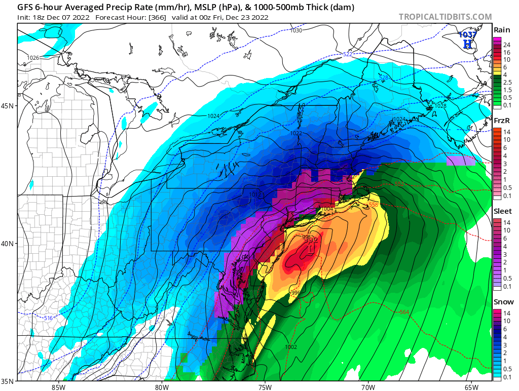
Deadbeat parents looking for last minute gifts spending Christmas in their buried cars on I-95. Oceanfront properties in Taunton encased in ice from sea spray blown in off the Atlantic like ICBMs. Jerry absolutely sloshed from a Crown bender and falling into snow banks on his walk through the neighborhood. TBlizz meh’ing the blizzard while on his toilet and then screaming for his wife as the ceiling caves in and buries him in slate shingles and paste. Police departments inundated with calls of middle aged men disrobing and shoveling driveways mumbling “is this what it feels like to live at 500mb”. We hope to see it. We pray to see it. We need to see it.
-
Oh how we pray.
-
I know. Just messin around. That’s a beautiful run though. ATL to Portland Category Four KU.
-
Back it west please.
-
Boston obliterated at 207
-
Snow into Atlanta on this run and riding up the coast (through 198) lol
-
Excellent. This one has been on models going back to last week. Long and persistent signal for something high end, consistent with the pages and pages of pattern discussion going back to late November. My bar is just a warning event here. Keeping expectations in check for now but the upper level pattern and airmass looks good at this range imo…
-
Me too lol
-
We’ve done enough of those around Christmas
-
Preliminarily ... a medium impact partial Miller B, Friday
WxWatcher007 replied to Typhoon Tip's topic in New England
Actually told my wife the other day that I might consider a truck because I’ve found with the new house there’s a lot more I could do with one. I’ve chased virtually all my big snow events in my car without snow tires, but I know its limits. Pushed it to the max in Buffalo but made it out fine. Elevation would be very tough. -
Preliminarily ... a medium impact partial Miller B, Friday
WxWatcher007 replied to Typhoon Tip's topic in New England
Dude -
If it doesn't produce snow, it better produce enough rain to flood my backyard, enough wind to put a tree through my deck, or enough cold to immobilize my car. Big dog or bust for next week.
-
Preliminarily ... a medium impact partial Miller B, Friday
WxWatcher007 replied to Typhoon Tip's topic in New England
Long at peace with this one. The setup is the setup. Congrats NW. Helps to have snow cover lol. -
100%
-
Good luck, everyone.
-
It's been on the guidance for a long time. Just happened across this gem on my computer
-
January ‘16 was extraordinary in DC. We kept waiting for the rug to get pulled and it never happened. I think it’s also worth noting that the Friday threat had been signaled for a while too. Models have done well highlighting potential so far imo. Placing my bets on a HH GFS run.
-
Yeah get that to the Atlantic please. My goodness.
-
Preliminarily ... a medium impact partial Miller B, Friday
WxWatcher007 replied to Typhoon Tip's topic in New England
If that did work out, most of the forum would have had at least one “wintry appeal” event. Stubborn to the end. Hopefully we get a few more ticks through tomorrow to put me in the game for a few. Tall order I know, but at the very least it’s good to see this be the second consecutive event that trends positive at short leads for parts of the forum. -
Next week looks nuclear. We don’t need to be the jackpot zone this far out, just in the game. It’s far closer at that lead time than Friday ever was.
-
Preliminarily ... a medium impact partial Miller B, Friday
WxWatcher007 replied to Typhoon Tip's topic in New England
Stubborn to the end