WxWatcher007
-
Posts
35,736 -
Joined
-
Last visited
Content Type
Profiles
Blogs
Forums
American Weather
Media Demo
Store
Gallery
Everything posted by WxWatcher007
-

The last hurrah? Putting all the eggs in the Tuesday 3/14 basket
WxWatcher007 replied to Ginx snewx's topic in New England
Right. I hope it’s wrong but I’m prepared for an LES type gradient because that’s what it looks like. It’d be horrific but it is what it is. -
The last hurrah? Putting all the eggs in the Tuesday 3/14 basket
WxWatcher007 replied to Ginx snewx's topic in New England
That would be catastrophic EOR. Dear Lord. -
It is what it is. Enjoy yours too lol.
-
36.7/35 with all rain still.
-
The last hurrah? Putting all the eggs in the Tuesday 3/14 basket
WxWatcher007 replied to Ginx snewx's topic in New England
Exactly. You just have to hope all hell breaks loose and you drop enough cement on the trees and lines that the grid collapses when the eyewall crosses. -
The last hurrah? Putting all the eggs in the Tuesday 3/14 basket
WxWatcher007 replied to Ginx snewx's topic in New England
Landfalling blizzard? Good luck out there. -
The last hurrah? Putting all the eggs in the Tuesday 3/14 basket
WxWatcher007 replied to Ginx snewx's topic in New England
That’s not bad for the WOR crew. Ugly for the rest of CT. -
We need a widespread 4+ in The Valley to get close to that, I think.
-
The last hurrah? Putting all the eggs in the Tuesday 3/14 basket
WxWatcher007 replied to Ginx snewx's topic in New England
Yeah, I’m long past ready to be done at this point. Punted in December. Watched people fawn over ten day virtual potential every week since. It’s like the clockwork orange scene but for four months. -
Echoing this: no matter what happens the folks that get crushed should post plenty of pics and videos.
-
That's f****** awful. Absolutely f****** awful.
-
38.4/36 Rain .22 on the day
-
The last hurrah? Putting all the eggs in the Tuesday 3/14 basket
WxWatcher007 replied to Ginx snewx's topic in New England
It really is. I’m mesmerized by the visible loop. It’s going to be a beast. -
The last hurrah? Putting all the eggs in the Tuesday 3/14 basket
WxWatcher007 replied to Ginx snewx's topic in New England
-
The last hurrah? Putting all the eggs in the Tuesday 3/14 basket
WxWatcher007 replied to Ginx snewx's topic in New England
If it’s anything like tropical I think it’d be 00z, which isn’t particularly helpful for the GP because forecasts are out…and they’re overnight runs. -
The last hurrah? Putting all the eggs in the Tuesday 3/14 basket
WxWatcher007 replied to Ginx snewx's topic in New England
Yeah I don’t really get it, unless this is more of a research flight. God knows we need to understand wtf happened with the guidance here. -
The last hurrah? Putting all the eggs in the Tuesday 3/14 basket
WxWatcher007 replied to Ginx snewx's topic in New England
Oh you’re good. Everyone else not so much. I don’t even care at this point. Let’s just get on with it. Good luck up there. -
The last hurrah? Putting all the eggs in the Tuesday 3/14 basket
WxWatcher007 replied to Ginx snewx's topic in New England
And with their leader finally capitulating to the king of awful winters, the patient winter weenies of Connecticut quietly fold. Welcome to the other side. -
The last hurrah? Putting all the eggs in the Tuesday 3/14 basket
WxWatcher007 replied to Ginx snewx's topic in New England
Then this will be the worst winter in the history of Connecticut. Not even close. 1935 Boston Braves level of putrid. -
43/37 Drizzle
-
The last hurrah? Putting all the eggs in the Tuesday 3/14 basket
WxWatcher007 replied to Ginx snewx's topic in New England
I really do think that outside of Kev land and NW CT expectations should be low, but there’s a reasonable range of outcomes that includes 4-6” of cement that causes major issues. It’s the toughest forecast I’ve ever done. -
The last hurrah? Putting all the eggs in the Tuesday 3/14 basket
WxWatcher007 replied to Ginx snewx's topic in New England
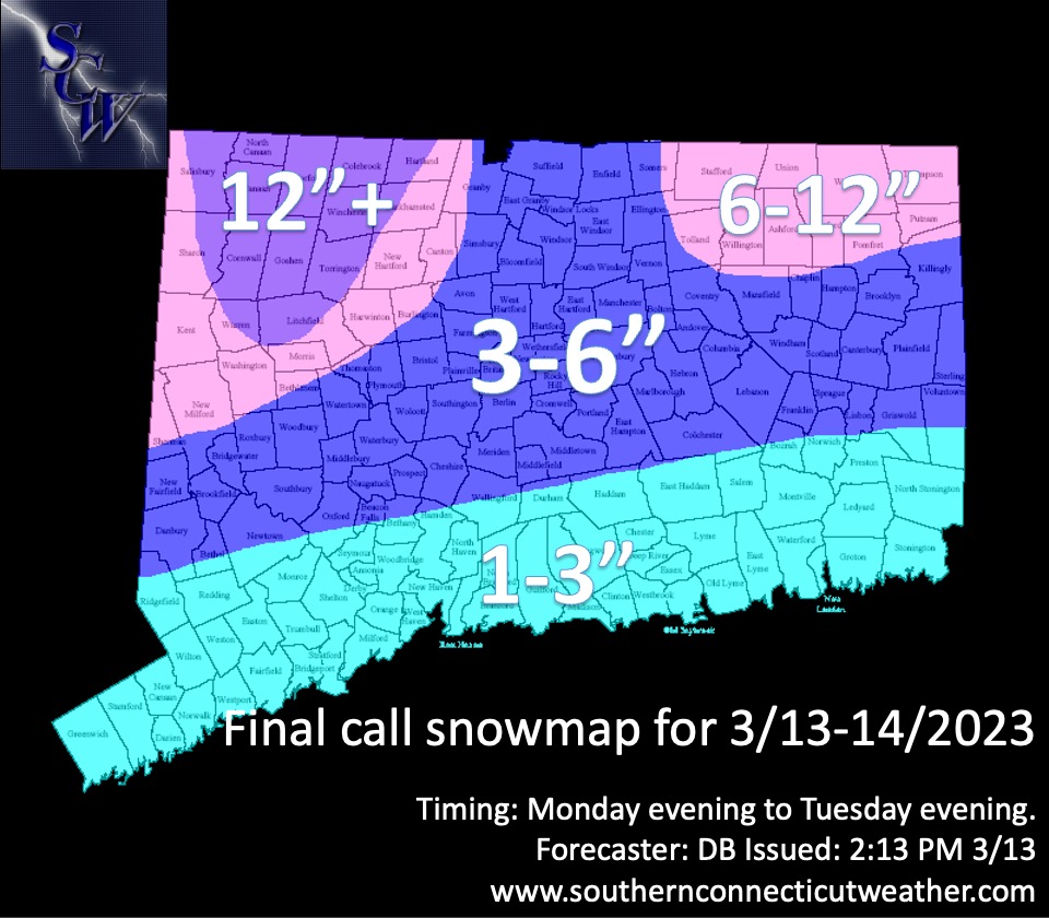
Last call. Cut back from 2-4 to 1-3 in the southern zone and expanded it north a bit. Congrats NW and NE. Chips fall mode.
-
The last hurrah? Putting all the eggs in the Tuesday 3/14 basket
WxWatcher007 replied to Ginx snewx's topic in New England
Chips fall mode. Done with the model crap. -
The last hurrah? Putting all the eggs in the Tuesday 3/14 basket
WxWatcher007 replied to Ginx snewx's topic in New England
-
The last hurrah? Putting all the eggs in the Tuesday 3/14 basket
WxWatcher007 replied to Ginx snewx's topic in New England
Yeah, you’d think it would be better based on the upper level depiction.