hudsonvalley21
-
Posts
4,228 -
Joined
-
Last visited
Content Type
Profiles
Blogs
Forums
American Weather
Media Demo
Store
Gallery
Everything posted by hudsonvalley21
-
May 2020 General Discussions & Observations Thread
hudsonvalley21 replied to Rtd208's topic in New York City Metro
-
Classic
-
Missed here too. Fell apart.
-
Special Weather Statement National Weather Service New York NY 645 PM EDT Sat May 9 2020 CTZ005>012-NYZ067-068-070-092345- Southern Middlesex-Northern Fairfield-Southern New London-Southern Fairfield-Northern New London-Northern New Haven-Northern Middlesex-Southern New Haven-Putnam-Northern Westchester-Orange- 645 PM EDT Sat May 9 2020 ...FAST MOVING BANDS OF SNOW SQUALLS WILL AFFECT PORTIONS OF THE LOWER HUDSON VALLEY AND SOUTHERN CONNECTICUT... At 640 PM EDT, National Weather Service Doppler radar showed bands of snow squalls extending from Bristol to New Fairfield to near Kerhonkson to Maplewood to Gibson. Movement was southeast at 50 mph. Winds up to 45 mph and visibilities 1/4 to 1/2 mile are likely with the heavier squalls. These squalls will be near... Cheshire and Bethel around 645 PM EDT. Newtown around 650 PM EDT. Meriden and Middletown around 655 PM EDT. Bridgeport and Middletown around 705 PM EDT. Shelton and East Hampton around 710 PM EDT. New Haven and Milford around 715 PM EDT. Chester around 720 PM EDT. Brewster and Carmel around 730 PM EDT. Cold Spring and West Point around 735 PM EDT.
-
Nice snow squall to our northwest. Let’s see if it holds together. Special Weather Statement National Weather Service Binghamton NY 344 PM EDT Sat May 9 2020 NYZ009-015>018-022>025-036-037-044>046-055>057-062-PAZ038>040- 100000- Northern Oneida-Yates-Seneca-Southern Cayuga-Onondaga-Steuben- Schuyler-Chemung-Tompkins-Madison-Southern Oneida-Cortland- Chenango-Otsego-Tioga-Broome-Delaware-Sullivan-Bradford- Susquehanna-Northern Wayne- 344 PM EDT Sat May 9 2020 ...HEAVY SNOW SHOWERS EXPECTED THROUGH THIS EVENING... Scattered heavy snow showers will continue through this evening. Localized accumulations of 1 to 3 inches will be possible across higher terrain, with a coating of snow possible at lower elevations. In addition, heavy snow squalls will cause rapidly changing travel conditions with visibility less than a quarter mile and slippery spots on roads.
-
BxEngine will be parked around the corner from you with the heat on high and the windows open. This model has that factored in
-
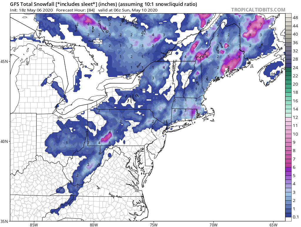
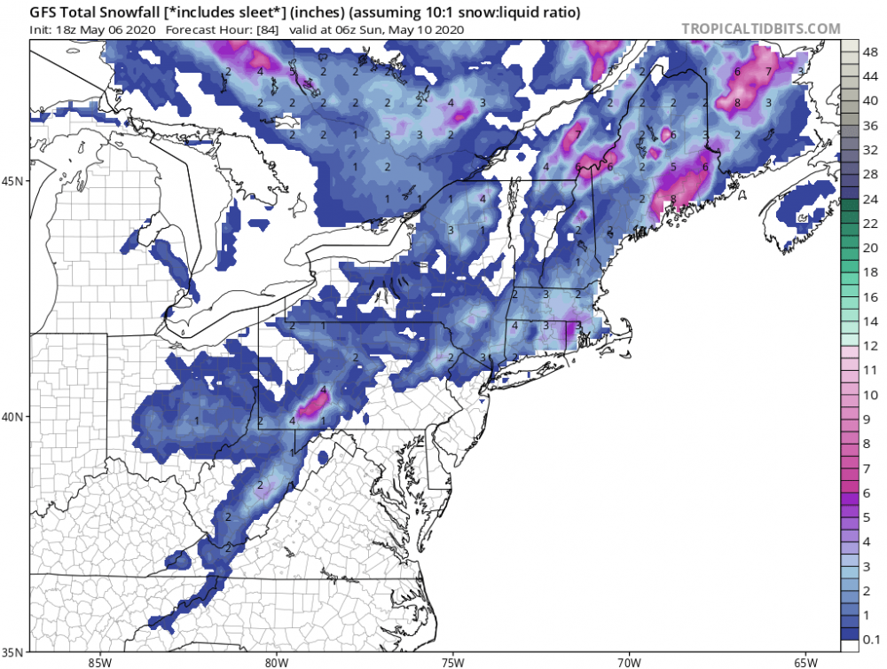
Might as well put this map too. Let’s go all in.
-
May 2020 General Discussions & Observations Thread
hudsonvalley21 replied to Rtd208's topic in New York City Metro
Maybe they could add a few more languages to the signs. It could be that these pictured future world leaders aren’t familiar with the languages that are posted. -
A very noticeable change from 24 hours ago, currently 49 degrees and a wind steady around 20 mph. This time yesterday 73 degrees.
-
1.22 in the Davis for the event.
-
May 2020 temperature forecast contest
hudsonvalley21 replied to Roger Smith's topic in Weather Forecasting and Discussion
DCA -0.7 NYC -0.8 BOS -0.9 ORD -1.2 ATL + 0.9 IAH +1.4 DEN +1.7 PHX +2.5 SEA +1.3 -
Same here, the furry little rodents hit my tomatoes too. Then the friggin birds hit the blue and raspberries.
-
Agree, I will be definitely concerning to go to beaches, sporting events, concerts etc. when things finally open up. What will be the new norm. We’ll see.
-
Not too bad, small place that can fit about 30-40 people. Weeknights are better no rif-raf
-
A bunch of the mom and pop restaurants and local bars are closed. Hope it won’t be long so they can reopen before they hit the point of no return. A buddy of mine owns a small tavern and is closed, he is back driving trucks. Down to 36 and some white rain mixing in.
-
All liquid here 37 currently.
-
That’s if they don’t beat you to the rabbits. Plenty of snowshoes here, Chinese takeout place closed the last couple of weeks due to the virus.

-
Good to hear you’re moving in the right direction
-
Wow, I haven’t heard of that condition before. Wishing her well and speedy recovery. Hope all is well with you Rjay.
-
Glad to hear the tests came back negative . Hopefully tomorrow will be nicer weather to get out for a walk or a ride on the bike cycle.
-
Good to hear your both feeling alright. Thoughts and prayers for you both and your tests coming back negative.
-
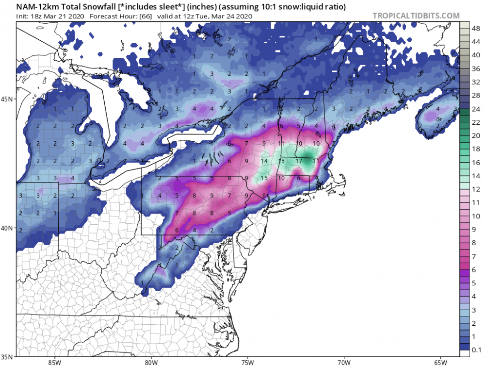
That should be enough to jinx it. I was going to put my snowblower away and open up the pool here is today’s 18z silly NAM
-
Something to watch instead of sports re-runs. We’ll see, stay healthy!
-
Well at least were in the same state URGENT - WINTER WEATHER MESSAGE National Weather Service Buffalo NY 1258 PM EST Wed Feb 26 2020 NYZ006>008-270200- /O.UPG.KBUF.LE.W.0004.200227T1200Z-200229T2300Z/ /O.NEW.KBUF.BZ.W.0001.200227T1200Z-200228T2100Z/ Oswego-Jefferson-Lewis- Including the cities of Oswego, Watertown, and Lowville 1258 PM EST Wed Feb 26 2020 ...BLIZZARD WARNING IN EFFECT FROM 7 AM THURSDAY TO 4 PM EST FRIDAY... * WHAT...Blizzard conditions expected. Total snow accumulations of 3 to 4 feet across the Tug Hill Plateau, and 1 to 2 feet for surrounding lower elevations. Winds gusting as high as 50 to 60 mph will result in severe blowing and drifting snow. * WHERE...The Eastern Lake Ontario Region.