Wxoutlooksblog
-
Posts
1,202 -
Joined
-
Last visited
Content Type
Profiles
Blogs
Forums
American Weather
Media Demo
Store
Gallery
Everything posted by Wxoutlooksblog
-
Not for Long Island and most of Queens. WX/PT
-
We've come around to many of the models now showing light snow for at least a time with at least 36 more hours to go. Additional changes possible/likely. WX/PT
-
We'll see it could also go the other way and the winter pattern could last until the first week of April, but I hope not. Some of the longer range climate models had a change to warmer in the east around mid March but they've been essentially wrong for most of the winter. WX/PT
-
I think the second half might be. WX/PT
-
I do believe that there's a likelihood that this comes back a bit. How much is the question. The models have done their typical fluctuations and in the end it is normal and typical for this kind of storm to come a little closer than the wide swing to the right indicated. WX/PT
-
I've seen 70s to near 80 and snow 3-4 days later. March is a time when the temperatures often swing wildly back and forth. WX/PT
-
My gut feeling right now is that it probably won't come back but I cannot draw that conclusion absolutely for a few more run cycles, probably 12Z tomorrow and 00Z Tuesday. At the moment all we have for hope is the NAM (which is not much) and a few outlier ensemble members. Everything else is a "not happening" and in the last 8 hours has been getting worse, not better. But in the passed we have sometimes seen an unexpected reversal in trends within the last 72 hours. So I wait until tomorrow night or Tuesday 12Z to sound the "all clear". WX/PT
-
I wouldn't be sounding an "all clear" for this storm until tomorrow night the earliest, Tuesday night the latest. WX/PT
-
If you get a trend back from Icon it will probably be 6-12 hours prior to the onset of snow (if there is any). Icon is not one of the top tier models. ECMWF is still the best, GGEM very good, UKMET good. I'd look for changes in one of those three models to signal a reverse in trends if it is to be. Icon and GFS would not be first to the punch bowl. WX/PT
-
Originally it was overnight Wednesday into Thursday with the bigger storm, now we are looking at a Thursday event. WX/PT
-
Nam is going to get the snow into NYC. At this point, that's all you'd want to see. Nam seems almost as good as 18Z. So it holds serve. WX/PT
-
Totally agree. I think we are still seeing the normal model fluctuations that we see before most of them narrow down to more of a consensus. Once we get to President's Day we should begin to see a more clear cut trend. They will probably continue to go back and forth debating the track and position of the upper low, the kicker, and the surface track for the next 24-36 hours. Right now, I think this can end up going either way. But it certainly looks better than earlier and than on the other models. WX/PT
-
Fluctuations back and forth of models' tracks are normal at this time-frame. It is NOT time to write off a very big storm for the NYC Metro Region. 2 days prior to the Boxing Day storm it was modeled to go out to sea. WX/PT
-
That's pretty common. A pattern establishes itself and the same areas get hit time after time in a given season. I still think this has a chance to veer back to last night's and yesterday's track. WX/PT
-
Given high pressure positioning and dynamics I'm a little skeptical of this "flip to rain". WX/PT
-
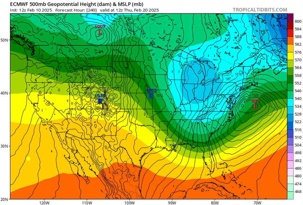
GFS doesn't make much sense. We have a closed upper low west of us. It pulls the low pressure system right up the coast offshore as shown by virtually every other model except the ICON. Even the ensembles support the track up the coast. Right now IMO the odds heavily favor it not that it couldn't change. It could. But we will watch the trends. This could possibly be a KU storm with potential for a foot or more of snow. WX/PT
-
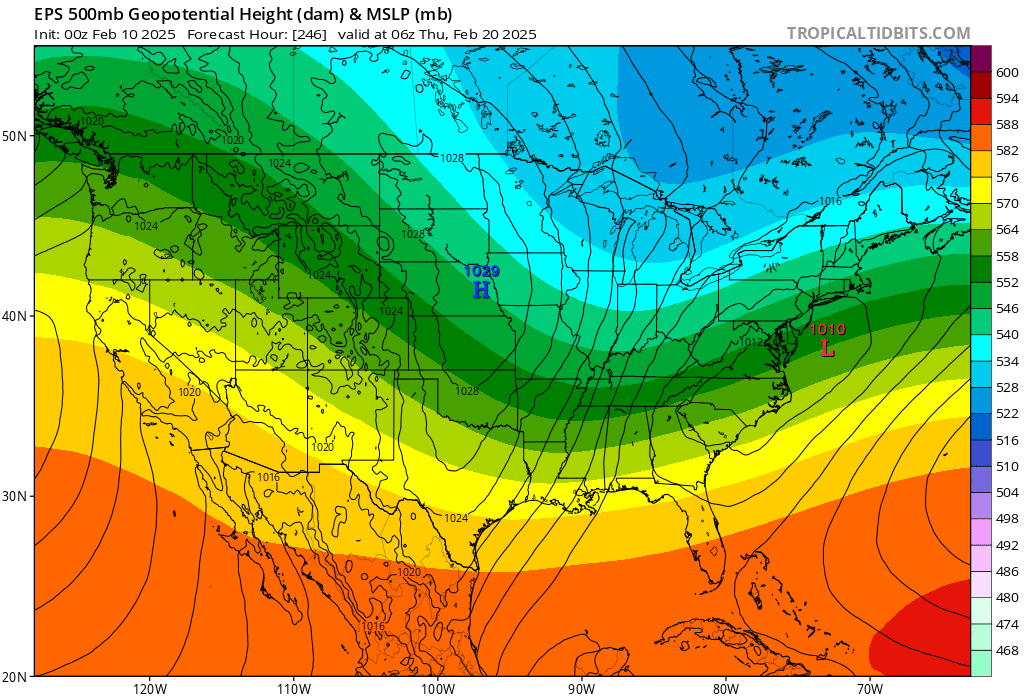
The Euro operational has a storm which if these maps verified (which they almost certainly won't) would suggest a major snowstorm possibly KU the 19th-20th. WX/PT
-
On most of the operational models at 12Z and 00Z now we are starting to lose the great pattern they had up until today. The only model holding onto it is the GGEM from which the storm right after Presidents Day might be suppressed way to our south if it even has a chance to develop. WX/PT https://www.tropicaltidbits.com/analysis/models/gem/2025021000/gem_mslp_pcpn_frzn_us_38.png
-
Heavy sleet in Douglaston
-
Pretty close to Cantore-Thundersnow though it's possible we just stay active with lesser amounts of snow for now and get a bigger storm towards President's Day. This is the best looking pattern we've seen in a while but I'd still prefer it if it were not so fast. WX/PT
-
Timing? Just as I drove by the speed camera on Northern Blvd on my way back from the gym in Great Neck I saw a flash. I think it was lightning as I was only going 29mph in a 30mph zone. Anyway 1" on my car in Great Neck and it looked like an inch on the ground in Great Neck, a little less here in Douglaston with light snow falling. WX/PT
-
Agree. 1-4"NYC Metro. 2 miles done 1 to go. WX/PT