Wxoutlooksblog
-
Posts
1,202 -
Joined
-
Last visited
Content Type
Profiles
Blogs
Forums
American Weather
Media Demo
Store
Gallery
Everything posted by Wxoutlooksblog
-
I'm looking for September heat and not finding it for the NYC Metro Region. We get a little ridging for a day or two in the east with onshore winds. Warmest weather Sept 11-15 probably over the top. WX/PT
-
Surprised not to see 2002 and 1991 mentioned somewhere in the top ones. WX/PT
-
I was away in Provincetown for a week. It seems every time the models show the pattern changing to much cooler here they then back off of it some a run or two later. WX/PT
-
Perhaps you missed my many subsequent posts in which my outlook on summer changed a bit. So far it has been a seasonably warm summer overall though overnight low temperatures have tainted averages upwards. But there has been no relentless heat only 3-4 day spurts of it. It is the high overnight low temperatures that help this summer to average out hot. Nevertheless you have back tracked to post in April or May which is quite a long time ago in the weather-world. And this weekend's weather was relatively cool at the coast (60s at night) but warmer inland. And such will be the case this week though temperatures should be about normal or slightly above overall for the first week of August. The second week looks above normal right now. But this is not relentless heat like the very hot summers. WX/PT
-
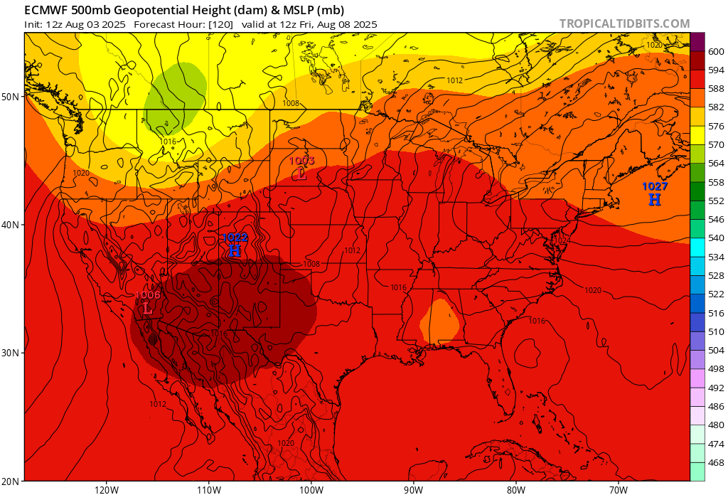
Lowering heights in the Great Basin and northern Rockies region should ultimately result in rising heights out east at some point during the second week of August. WX/PT
-
Doubtful locally except for EWR where it's almost always likely and some points well north and west. I would think Central Park 87, LGA 85, EWR 91. WX/PT
-
I'm going to partially disagree with a some things that have been said. Firstly, I think the onshore flow around the relatively cool HP is mostly this week. Then from what I'm looking at there is a fairly brief spell of warmer/hotter weather later in week #2 pending no significant tropical activity up our way. GFS thinks there will be some. Then it appears a fresh Canadian air mass drops southeast bringing possibly a spell of well below normal temperatures by sometime during week #3. After that I speculate purely based on the pattern that we may see one last or the second to last spell of heat as the ridge builds around on the return flow of that air mass probably not long duration but we'll see. All in all, it looks like an average to slightly above average August temperature-wise. WX/PT
-
July 2025 Discussion-OBS - seasonable summer variability
Wxoutlooksblog replied to wdrag's topic in New York City Metro
Totally agree with this. The heat just keeps on building back possibly into early September. In addition, I do not think the "cool down" is going to be quite as cool as it earlier appeared to be. WX/PT -
July 2025 Discussion-OBS - seasonable summer variability
Wxoutlooksblog replied to wdrag's topic in New York City Metro
I think it could be just noise but the GFS backed off the extreme heat a little at 00Z. NAM would suggest it's still on for Wednesday. WX/PT -
July 2025 Discussion-OBS - seasonable summer variability
Wxoutlooksblog replied to wdrag's topic in New York City Metro
Cancel my several days back post of mostly lower 90s the rest of the way with it now looking like this Wednesday in NYC could end up between 95-100. WX/PT -
July 2025 Discussion-OBS - seasonable summer variability
Wxoutlooksblog replied to wdrag's topic in New York City Metro
Way over performed my expectations. Certain locations will over perform today & Sunday if there is enough sun but Mon & Tues should get back to 90. WX/PT -
July 2025 Discussion-OBS - seasonable summer variability
Wxoutlooksblog replied to wdrag's topic in New York City Metro
Most of the hot weather from here on out appears to me to be borderline heat as in upper 80s to lower 90s not the kind of furnace heat we saw the last week of June. While I can't rule out one longer heatwave sometime in August featuring again, mostly lower 90s, I think the odds are slightly against it. I am concerned about a pattern which to me looks ripe for tropical development off of the southeast coast of the U.S. or in the southwest Atlantic. And we'll have eventually what I'd call a dirty ridge over most of the east up into eastern Canada during August with some upper lows embedded at times that could pull a storm northward up the eastern seaboard. I guess on Friday NYC could get up to about 92 or 93. WX/PT -
July 2025 Discussion-OBS - seasonable summer variability
Wxoutlooksblog replied to wdrag's topic in New York City Metro
Beginning to get a sense that NYC's hottest weather of this season may be behind us. It's frustrating that WAR showed early signs of becoming prominent in our weather pattern but the latest models practically disappear it putting almost all the focus on the western ridge more and more-so as time goes on. It could change but right now it's hard to see WAR getting back into the picture. WX/PT -
I am watching that for both severe and flooding potential. WX/PT
-
July 2025 Discussion-OBS - seasonable summer variability
Wxoutlooksblog replied to wdrag's topic in New York City Metro
Eventually I think there's a chance of that. More likely later on. WX/PT -
July 2025 Discussion-OBS - seasonable summer variability
Wxoutlooksblog replied to wdrag's topic in New York City Metro
I think we could turn that around a bit either later in July or in August. More likely in August. WX/PT -
I think most of these storms will probably continue to dry up prior to getting to me. Still there's a chance one sneaks through I think the later is the more likely. Tomorrow some peaks of sun and mid-upper 80s with higher humidity with the approaching cold front should lead to somewhat more widespread t-storm activity later tomorrow afternoon & tomorrow night. There's still just a chance that the bulk of the activity stays west and southwest of NYC only crossing through the area as it weakens tomorrow night. But it could hold together and give us a soaking too. We'll see. WX/PT
-
Great WAR late in the forecast period on Euro & EPS. Looks like lots of 90+ days on the way. We haven't seen this in quite a while. WX/PT
-
My 5th floor apartment in Douglaston facing west with open sky got so hot with the westward facing wall of the building and now an easterly wind I am running my a/c full blast to try to fully get the heat out. I ran it all night last night and probably will need to run it over night another night to finally get it comfortably cool. Then it warms up with plenty of humidity on Saturday. Unless we sneak a 90 in on Saturday, Sunday, Monday or Tuesday (and it's unlikely since winds will be out of the s-sw) I do not think we see another 90+ day in NYC until the second or more likely the third week of July. WX/PT
-
Possibly hot again by Sunday through Tuesday. WX/PT
-
Go out and celebrate. I was supposed to go to a cocktail party in Manhattan but decided to stay put. WX/PT
-
88 WX/PT
-
For the Euro we once knew, it is. I don't think it's quite as good today. WX/PT
-
I am doubtful that we hit 100. The pattern is too active with too many pop-up storms. Once the dew points get to a certain point lift in the atmosphere will easily pop storms. I am looking for 93 at Central Park tomorrow and 98 on Tuesday, 92 on Wednesday. WX/PT
-
EWR always hits 90 on marginally hot days. They should make it. But Central Park with 81 at 3PM and a high thin overcast is I think unlikely. Yes there could be a spike over the next 2-3 hours but I think mid-upper 80s would probably do it for today. Look for an extremely warm and humid overnight, however and temperatures probably to rise to 90-95 degrees by lunchtime tomorrow. I am comfortable going for a high temperature of 86 today and 93 tomorrow, 98 Tuesday. But we shall see how possible storms affect this. They should be well to our north mostly. WX/PT