FallsLake
-
Posts
6,318 -
Joined
-
Last visited
Content Type
Profiles
Blogs
Forums
American Weather
Media Demo
Store
Gallery
Everything posted by FallsLake
-
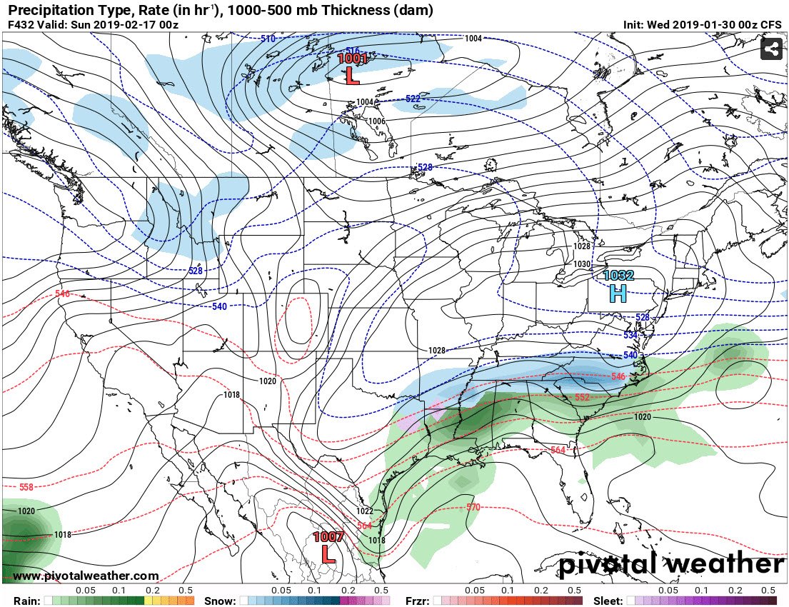
Hour 432 on the CFS is looking good :
-
Good...that may bring the snow. If you had ordered a snow shovel we would have been doomed.
-
Great game! I would love to see Brady win one more.
-
I keep saying this, but you guys are due. I actually think this is the perfect "forecasted" pattern to give coastal areas snow. Strong blocking with strong highs that can suppress the storm track way south. Then when something does pop, you guys snow. **also if it gets cold enough, it would be cool to see bay effect snow again.
-
Yeah, the upstate of SC up to your location have had bad luck the last couple of years. There's been numerous storms where you're suppose to get a big storm and it doesn't pan out. That's probably worse then the folks farther east that were never in the game to get anything.
-
I have no complaints, but there are folks in SE NC, SC ,and Ga that are in a long snow drought (maybe half the board??). I would love to see at least one deep south and coastal snow storm; even if I got shutout. It seems like its been ages since the last one.
-
Take a look at the latest FV3. But you might be a little too far north...
-
With the pattern change and with so much cold air moving into the US, I think we can only use the models out to about day 9. We're seeing big swings in the later days with each model run. The one big constant is the availability of cold air. It still may be early February until something pops, especially if we get unlucky with the day 10-16 period. But the euro weeklies and many mets think the rest of winter is going to be on the cold side. I think we're looking good. On a side note; many have posted what they would consider a good (A score) winter. I have four things: 1) Significant snow event (Check----already had the 12" in December) 2) Significant arctic outbreak, with at least a couple of sunny days with highs below freezing (looks like that is coming) 3) Significant winter event, which can be a mixed bad but has to limit driving, etc. (waiting) 4) Small winter event, which can be mixed bag but is picture worthy (waiting)
-
I think the thread and timing was fine. It'll still be an event for some of the folks on this board (NW NC / S. VA). Also we can't win them all; meaning we'll track storms and lose them. Winter can still make a come back. We've had at least a few fab Februarys.
-
At least I'll sleep better tonight; not waking up to check the 0z model runs.
-
Lol...I'm not giving up hope but we really needed todays models to trend better. Maybe (just maybe) we get lucky with the Mondays event.
-
I was told this is where the party is....
-
If things go like planned, this year will be a reversal of last; whereas we have a back load winter. Remember last February heat wave.
-
Happy New Years everybody! Lets hope we can score two or three good winter storms for most on the board.
-
Don't give up yet. As long as we flip to a favorable pattern by the end of January, we have a (good) chance. There were a few folks that predicted a back-loaded winter. Lets see if they end up being correct. **Wouldn't it be terrible if we didn't flip to a cold pattern and ended up with a repeat of last February.
-
If all that cold verifies for January (meaning some good blocking), there'll be some suppressed storm tracks.
-
It seems that when the p-type was snow and it was below freezing (making close to 10:1) it was actually very close. Some of those huge outputs (over 2" in the piedmont) was more tied to the higher QPF that was originally being forecasted.
-
You live in a good "zone". I remember you did well last year in that early January storm; whereas I got about an inch. Then we both did well in the late January storm. Folks south and east of Raleigh have missed out the last few years. I feel (in my bones) that's going to change this year; a coastal plain blizzard is in order.
-
It is amazing how that line sets up. I've been really lucky the last few years where I've been just north and west enough to get in on the good snow totals. In past years I've noticed that things even out somewhat with those "eastern storms" -- Fayetteville NE to Rock Mount. With those storms eastern parts of the Triangle do very well. I've seen it snowing hard just east of Wake Forest but nothing at my house. I think we're due for another one of those storms. And as other have said, I would gladly give up snow to see you guys score.
-
Still very light snow at my location. This should be it. Now the question is how much melting this afternoon. Then how bad will the roads get tonight with the refreeze. I think tomorrow morning may be the worse driving conditions of the event. Folks will see what looks like clear pavement but actually slide on ice. Get ready for lots of reports of wreaks. Edit: sorry I thought I was in the observation thread.
-
Man after all the snow we're getting this storm is not over (ICE): As this occurs, the forecast low level partial thicknesses in the 1295 to 1305m range indicate more icing can be expected SE of the heavy snow zone in the NW add N Piedmont. That would place areas from portions of Stanly and southern Davidson ENE in an arc through portions of Randolph, northern Moore, Lee, Chatham, Wake, Durham, Franklin, Vance, Granville, and Warren at risk for 0.25+ of icing later this morning into the afternoon. Surface wet bulbs support the area from near Troy and Asheboro to NW of Sanford to near RDU and Henderson in the 32 or below through the event. This will have to be watched closely as Raleigh will be right on the 31-32 line with 33 degrees just 10-20 miles east and south.
-
HRRR looks good for our area. 2z is out to be 12 and there's plus 6" totals through the Triangle. And it's still snowing.
-
^^and that's why we see jumps every few hour. As the models change their depictions the values are then pasted on to your respective grids.
-
Hey I really appreciate it! For others, here's the versions that were released: V1.0 - V2.0 The first version of the NBM was released January 6, 2016 in CONUS AWIPS 16.1.1, after Congress mandated that the NWS develop a blended model approach following Hurricane Sandy in 2012. This first version used 3 models (GFS, GEFS mean, CMCE mean) and covered temperature, wind, and sky cover over the CONUS (Continental United States) region two times a day. Version 2, released November 15, 2016 in CONUS and OCONUS (outside-CONUS) AWIPS 16.2.2, added coverage over Alaska, Hawaii, and Puerto Rico. V3.0 Version 3.0, released July 27th, 2017 (AWIPS 17.3.1) incorporated additional global and mesoscale models for the CONUS, OCONUS, and Oceanic domains along with running hourly and providing 1-36h forecasts. Several new weather elements were added to this version such as calibrated Probability of Precipitation (6-hour) and QPF, ceiling height and visibility, and weather, snow, and ice forecasts to name a few. An exhaustive lists of weather elements added to V3.0 can be found in NWS SCN 17-59. V3.1 NBM V3.1, which is planned to be implemented October 3, 2018 (AWIPS 18.1.1) will continue to incorporate additional global models (i.e.., ECMWF (deterministic and ensemble)) and mesoscale models (i.e., HRRR-Extended (1-36h guidance)) into its suite of model guidance to cover the CONUS, OCONUS, and Oceanic domains. This upgrade will enable the NBM to fill existing product gaps requested by the Aviation, Fire Weather, Water Resources, and Marine NWS Service Program Offices. To date, NBM data has been packaged in GRIB2 and only provided forecasts at gridpoints. NBM V3.1 will introduce a new text product (similar to MOS-station bulletins) that will provide NBM forecasts at stations. The data in these bulletins are the NBM’s nearest grid point forecast to the corresponding station. We will be generating four individual NBM text bulletin products every hour, each covering different forecast horizons. For a complete discussion concerning these messages along with an exhaustive listing weather elements that will be added to NBM V3.1 and their dissemination times please see the following NBM V3.1 SCN.
-
Earlier today my NWS grid forecast was set at 5-9" for Sunday (daytime period). It was reduced to 3-5" after lunch time. Now it's been bumped back up to 3-7". Again, I'm wondering what models they're using to create these output. Anybody know?