Typhoon Tip
-
Posts
43,285 -
Joined
-
Last visited
Content Type
Profiles
Blogs
Forums
American Weather
Media Demo
Store
Gallery
Everything posted by Typhoon Tip
-
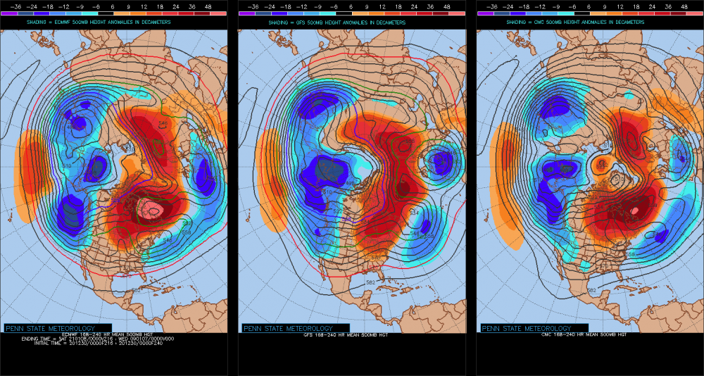
I have never seen this hemispheric layout before... It's almost a 2-wave rest state pattern. It just happens to have a couple nodes of ridging on the right, and troughing on the left to make it blurred, but that's about probably as close to a 2-wave structure as is mathematically possible given Earth geometry and mass-density/velocity ...
-
Significant upper middle Atlantic S/CNE mix/snow potential Jan 3+
Typhoon Tip replied to Typhoon Tip's topic in New England
'Course ... I will be the first to admit, 'live by the NAO die by the NAO' ... Not a huge personal fan of it as being as significantly 'forcing' - I still think a -NAO is equivalent to an "indirect Pacific" ...in that, the latter instructs the former, which then parlays in activity in that order ... but I don't wanna get beat up over it either . The 29th - if anyone recalls ... - had a promising look at D7 or so, but it too was contingent over the NAO's blossoming, which it was in the runs at that time.. But, every cycle immediately ensuing thereafter, gradually took more and more of the western oriented blocking off the charts .. until actually the opposite remained, and the 29th lost out in the shuffle... I dunno - it's a tough stochastic domain ... It's like the only field on Earth where the models can be wrong about a thousand*trillion tons of atmosphere in a single cycle ...massively changing its mode characteristic as a surgically intended strike on sanity ... heh Nah, but I think this has legs, this mode change.. that AO is dramatic and shares a large amount of NOA domain space.. Plus, this sort of concerts with the EPS previous NAO downward movement - it's been in the airs... -
Significant upper middle Atlantic S/CNE mix/snow potential Jan 3+
Typhoon Tip replied to Typhoon Tip's topic in New England
this run is behaving strangely .. It's trying to maintain the previous super-structure surrounding the advent of the NAO mode change throughout the D5-10 range of the run, but unlike prior solutions ...it keeps the 40 N train of waves moving at Maglev velocities ... That's buckin' for a progressive and retrograde pattern simultaneously - .. at least in concept. I'd be happier if this model would pick either rather than doing this ... -
Significant upper middle Atlantic S/CNE mix/snow potential Jan 3+
Typhoon Tip replied to Typhoon Tip's topic in New England
It may be the down stream handling of the flow ... It really appears to me like previous solution "force" an initially less than ideal S/W south, because of 'emerging' down stream blocking - like the former 'senses' the forcing ( previous runs ...) before it actually is there, and then it is ..and it makes sense that a vortex is situated between CC and NS... In this run, down stream delays just a bit and that delays the south suppression - But actually looking at this again .. .I think the impulse Will's noting there is being corrected perhaps too deep ...owing to what the Euro likes to do with S/W in this time range... and what that does is lifts the lead wave N...effectively detaching it from the baroclinic field along the MA --> weaker low in a marginal atmosphere heads this in the wrong direction. This run is mutable in my estimation - no worries... -
Significant upper middle Atlantic S/CNE mix/snow potential Jan 3+
Typhoon Tip replied to Typhoon Tip's topic in New England
sort of .. . That whole structure may be a snap shot en route to some destination ... That is probably true, because we "should be" seeing the N. Atln changes coming into emergence soon thereafter... anyway, that is a vague impression of a L/W axis out around 60 W or so, ... in terms of total wave spacing, it's in the ball-park. -
Significant upper middle Atlantic S/CNE mix/snow potential Jan 3+
Typhoon Tip replied to Typhoon Tip's topic in New England
That may also be open 'somewhat' to interpretation ..The Euro has the D. Str blocking a-bomb mushroom capping the flow by early on D7...in fact, is half way erupted by D6 already - it's sort of in the 'acceleration curve' of onset and ... you know, it's almost like there is a 'synergistic' to slow this bitch down that even seems to precede the 'westness' of the NAO.... Maybe that is the AO big brother watching lol -
Significant upper middle Atlantic S/CNE mix/snow potential Jan 3+
Typhoon Tip replied to Typhoon Tip's topic in New England
It's funny ...I actually like those.. I mean, I was back in the day geez.. 1997 even? wow, this Golden State Weather site was launched back then ...graphics et al were a primitive tech solution for delivery anyway, but that was actually considered a beautiful rendering compared to the pre internet DIFAX days ... haha.. Now that was primitive - but it was like those? Back between print out and internet ubiquity there was a period of machine-specific graphics handlers ...and the DIFAX charts *(AVN ) were black and white like that... Since I grew up Meteorologically in that realm...I kinda sorta like those because it's something I'm used to reading and associating to ... you know, real world deterministic needs and so forth. I look at those and they make sense immediately to me. Buuuut, having said that - agreed, they are primitive by today's standards no doubt. lol -
Significant upper middle Atlantic S/CNE mix/snow potential Jan 3+
Typhoon Tip replied to Typhoon Tip's topic in New England
It relates to that last bullet point(s) ... I was elaborating on the rather jolt halting in the total synoptic wave translation speeds, and that tandem hemispheric "flashing" in of the -NAO over the western limb of its domain space - partially instructing backlog, partially related to slowing overall. That is all happening like over the next 3 panels after this image above lol... so, yeah, you're caution is certainly warranted, and much of this is predicated on the slowing hemisphere actually succeeding ... It's not going West given that success... If not, up in the air as the pun goes. The other aspect tho is that the models ...pretty much none indicate a west motion with that deep layer wave space - regardless of the downstream train crash. Sometimes it might okay to nod to weighted consensus, too - it's hard since errors have been noted. -
Significant upper middle Atlantic S/CNE mix/snow potential Jan 3+
Typhoon Tip replied to Typhoon Tip's topic in New England
I think we do fine from Philly all the way up ... I mean, sans shore communities/or weird offsets.. urban heat island this.. or unlucky that.. But if we are talking just in general thermal field/synoptic dynamics, this probably is an isothermal blue snow at 33.5F 2-meter T's ...and then 30.5 in interior SNE at maturation - Granted, these are initial calls ... so, subject to change - but if I was gambler, that's what it looks like here initially. Euro will be interesting here - -
Dec (Edit: Jan1/..2 ) multi-faceted ptype mess potential...
Typhoon Tip replied to Typhoon Tip's topic in New England
It’s funny sometimes the peregrinations of these ‘threats’ I mean when this thread started out it looked just like this right now ... we spent a day day and a half 2 days on life-support, now we’re right back where it all started - granted it doesn’t always work out this way ... -
We only have 5 days before this starts formulating ...and 6 before go time... and this is kind of coming in the shadow of Jan 1/2 concern - I think it is time to get this out. Fast flow - sorry...gotta work with the time, friends. The main deterministic headaches for the robustly coherent signal ... Jan 4th + are ( and I am encouraging other Mets well-informed enthusiast inputs in this increasingly adaptive mid/ext range) : - Baroclinic recovery along Eastern Seaboard and immediately adjacent west Atlantic: If the January 1/2nd event sweeps the better baroclinicity more east, that it's another scenario where the mid range was overly assessing cyclonic/total wave amplitude ( it's an under the radar aspect I've noticed where the models seem to see 'events' out in time like the moon coming over the horizon at dusk like it's this looming celestial event!) - Rapid succession of Pacific wave input in a transitioning pattern; that does offer a bit of headaches for timing and placement .. We can be delivered faux stability across many cycles when surveying events in the late mid range+. But then.. something gets tasted into the grids, and boom: the models spit it back out a busted ravioli due to negative/destructive S/W space interference in an otherwise favorable super structure, and we taste the waste. ( hate that, knowing history is being avoided) Something to watch for... this Jan 4 set up is very fragile folks.. There are really not more than 2 ...maybe 3 ( depending on which member one uses) isopyses describing the trough... It is interesting though that there is till a 100 kt 500 mb jet max(s) ..and that intrigues me. - Virtually every member of the GEFs carry a trough through 80-70W with itinerant surface placements ..albeit still within consideration for said areas, upper MA/ SNE/CNE ... Don't mean to leave NNE out but this does presently look more southern oriented - stand by - Duration: I am intrigued by the explosive onset of -NAO. As modeled it is biased over the western limb of the domain space, which is key to orchestrating what happens after Jan 4.. I am not sure this thing really exists as fast as the GEFs camp tendency to progression as a separate model bias rule to the 'real' progression that is being lost in this transition - the former holds on a bit too long and carries things away too far East as a plausible emerging error. This almost smacks as Feb 1967 weirdness but not as a redux... just as general layout, we have an antecedent fast flow that is relaxing abruptly ( I suspect so...), and that immediately "strands" whatever is ongoing ... Think of an asshole careening thru and intersection and leaving a snarl and going on blithely unaware... The blocking/trainwreck near D. Straight pins and starts pinwheeling beneath..and there may still be residual Pac S/W schrapnel into the backside ... at relative scales, any one of which may be substantive to induce/ignite anew along the Del Marv to Benchmark cyclone conveyor. I suspect by weight what has really evolved to be a striking -AO enhanced Hemisphere. It is unclear/intensely suppositional whether the NAO subordinate polar field index is actually being forced to do the AO's bidding ... What I suspect is happening - personally - is that the relationship between those two is in fact "indirect" ... I think the AO is/has become so demonstrative it is effecting the large scale R-wave/planetary mode ...and that is one that is relaxing the velocity surplus that we've plagued with ...really going back multiple seasons actually.. Bit of uncharted waters here for that alone -we haven't been dealt this sort of arena ..or 'blessed' perhaps depending how this plays its cards...
-
Dec (Edit: Jan1/..2 ) multi-faceted ptype mess potential...
Typhoon Tip replied to Typhoon Tip's topic in New England
I think the secondary is real.. It's in the Euro... It's in less than popular/conventional model types ...they're jumping into the ante, not away...and, it is theoretically sound - Just imho - But, it's not a like a 1978 Miller B extravaganza here ... we're talking about modest mid level support for it, and BL resistance just barely being enough ( hence the fine art) ...so, provided no industrial farts act like chaotic butterflies downstream of the Petro complex up there near Hamilton Canada ... etc etc.. -
Dec (Edit: Jan1/..2 ) multi-faceted ptype mess potential...
Typhoon Tip replied to Typhoon Tip's topic in New England
I'm not sure I would frankly ... 'course, I have the biggest ballz of all event posters because I have no where else to go but up in life...heh... No, it's not unusual for the models to "see" the BL resistance/inhibition to cyclonic/warm intrusion only nearing an event, with more coherency and as I just opined... even the Euro with -10C at BTV over to mid Maine at 850s a mere 24 to 30 hours prior to saturable isentropic lift ... ...is a lot of long words to suggest that a cold profile has precedence for materializing out of models when the cold is arriving, not rotting ... The nascence of this may have been and probably was because of BL resolution ... moved out too quickly - thing is... some of these late runs ... seemed to hint 12z yesterday, bust has been trending more pronounced, have inched the +PP position up N ... backward relative to the modeled total translation of the event. Subtle but crucially ... that adds more said BL resistance and plus with 850 mb turning ENE-E at your latitudes near Brian and up by you... that means it is moving parallel to an elevated topography and that will force that layers ascent and that's a positive feedback at keeping the lower levels critically colder... The Euro also shows now a better backside 850 mb temp collapse ( -2 to -3C ) on the backside of that escaping middling secondary, which means it may have snowed to ping to upsloping snow upon exit. It's a fine art ... yup. But, I could see this thing staying snow at least longer for somewhere between the PF-Brian-Dryslot-Phinny axis of evil -
Dec (Edit: Jan1/..2 ) multi-faceted ptype mess potential...
Typhoon Tip replied to Typhoon Tip's topic in New England
Probably also more of a symbolic thing ... but, I noticed growing up around this latitude of interior eastern SNE ...over the many, many ...many years ..that icing events between ct-vt/nh latitude seldom entry as ZR.. There is more typically 2 to 3 inches of matting then a switch ... while the shrubbery and wires and tree limbs slowly begin to 'glow' if by day, or prism urban lights by night, the surface of the snow may even accrete enough that you can walk on the lawn. We all have our moments that stick out along the time-lines of our lives. They're just curious little nuances along the way that ... you just don't really avail an opportunity to share, so they're kept along. I remember a calm dusk on an Xmas Eve a few years ago, up in Dunstable. My sis' in-laws own a huge spread of land. It was cold. 23 F calm wind, the steam vapors seemed to want to fall from the chin rather then rise. The trees were still moderately burdened from a glazing event some two days prior, and the pasture's 3" inches of snow sheened the fading light. I took the moment for a solo walk out there, and it really would have been a crime to Nature's handiwork in any other ambience than cryo ... Almost heartbreakingly beautiful ... and just then, 'goo-goo goo-goo' , excuse me if I don't know how to spell the sound of ice report from over a lake or pond surface ...but the field actually spoke to me in that same exact way. I had never experienced anything like that.. As a first it was sort of outre - but since, yeah it makes sense that can happen; the flat expanse of a field of Earth, lane over by a 3" of snow pack then 3/4" of ice cover, probably would exact the same phenomenon. I'm getting artsy and nostalgically ahead of my self here ..still, I also recall so many times, almost all ice events seem to be forecast by TWC and NWS and the local stations, as transitioning to 39 F rain, prior to my education and knowing exactly why they would eventually bust too anxious to erode the cold... Whenever I'd see that I grew to almost expect, ..even getting excited that ZR was prooobably going to last longer than those anticipations ... Until I grew up and started connecting ice with consequence of no life and no power and well..heh, icing lost much of its cache with me but that's another discussion - But this smacks as one of those sort of deals where the ice lingers a bit longer, particularly now that we are getting the better meso expression in these recent runs - -
Dec (Edit: Jan1/..2 ) multi-faceted ptype mess potential...
Typhoon Tip replied to Typhoon Tip's topic in New England
Yeah, that's what stuck out for me first thing this morning... the tendency for that secondary - so much for not having a meso low, huh. You know ...that did strike me a little dubious before. I mean a little voice in my mind was thinking it's almost impossible not to have one given the total synoptic structures in this. To lay in a -10C 850 mb air mass as far S as nearly the NH/MA border just a mere 24 hours prior to the warm front kissing NJ, yet the models were selling only a vague curved PP around the boundary like that...? mmm So..two cycles, boom boom and they go right thru the meso look into a higher latitude quasi Miller B ...interesting... The reason I did not mention that before is because I was too pre-occupied with the 500 mb going so far west. That's strange too frankly - the core of the vestigial S/stream wave that rides up the ridge is so far west, that it almost argues for sequencing through a new wave space to finally get it through our longitude... I just kept focusing on that facet ...wondering if/when the other shoe would fall and we'd just up and lose this whole thing and have it morph into something else entirely.. But, that's not happenin' either... As it were, this entire thing is ending up excessively sloped in the atmosphere... I think now this thread's merit/relevancy has been returned based on what I see... And, we shall see... I'm not like giddy 100% for a moderate ice "event" ..but, I think the light to mod impact mix mess (S-N) idea has been taken off the c-19 ventilator and is breathing under its own power again... -
Dec (Edit: Jan1/..2 ) multi-faceted ptype mess potential...
Typhoon Tip replied to Typhoon Tip's topic in New England
Heh looks like icing “event” tries another go at it .. this ICON run back situates the high up N just enough to impress this as running into a polar wall. This suggests within 50-70 S of the snow is mod IP/glazing -
Dec (Edit: Jan1/..2 ) multi-faceted ptype mess potential...
Typhoon Tip replied to Typhoon Tip's topic in New England
Acknowledge runs coming in a degree or two colder over last couple of cycles… But this was still never going to be about snow in Southern New England and probably not even up to Manchester New Hampshire just keep that in mind - mix/ice. But typically these things do start out with aggregates for at least a small while I’ve seen IP columns be 10,000 feet deep -
Jan 8th just needs a southern stream injection and look out! ... as is, starved but that's an intriguing n/stream mechanical presence/handling there on this v16 run
-
Where is this warming event being observed - what source. How is it being defined.
-
heh...devil's in the details on those ending Euro frames.. yuck -... It's raining in NF on a long shore easterly beach eroder flow, with a low pinned under that block, ... in January Meanwhile, late March 850 mb thermal tapestry for every S of 50 N everywhere...
-
That GGEM run actually has three distinct Pac impulse rippling along in succession right out to the end of the run. Any one of those could do it ... It's an interesting look by the Euro, GGEM .. .the flow is 'relaxed' in the sense of height gradient - so the velocity saturation is alleviating for a change! Yet, the wave spaces them selves remain in a rapid progression.. It's an odd behavior.. That Euro block looks dubious up there... It almost looks like a 'latent heat landfill' ... The whole region between NF and England is like the land the atmospheric patternization forgot... So, It's formulating a soft gradient NAO black out of western Atlantic cyclongen exhaust.. mm okay... think about that. you go 564 to 570 dm height node with only three standard isohypses surrounding it before we find any kind of nadir ...that's a little dubious for a core winter month. It just seems everything is 'what the f' these days - man
-
You know ... if you glide your mouse over the 20 some odd members of the GEFs ... you can ' kind of tell ' how they want to build the actual Z depth height structure...but for some reason, most ( but not all..) settle for 'COL' ( or absence of pattern at all ..) ... That gives the allusion if you will, of a 'placeholder' ? Kind of like on stand-by in case they need to build one lol... I don't know...this last 10 years of management up there over that surface area of the Globe is intriguingly ill-performed and problematic if you ask me. The Pacific should be where the research is focused... sure, as the primary cold and S/W ejecta loading pattern(s) obviously begin there... But, when the flow is fast between Hawai'i and California ..then slows nearing the OV at mid latitudes over N/A ...I have come to find that precedes the N. Atlantic ridging - not sure if that's also useful up in the NAO domain ( D. Str. and Greenland and so forth...) but I bet there's a larger wave mechanical/Rosby argument for that. hm ...and once it is there.. .that "backwardly" fold the flow ...blah blah. Anyway, the flow has been fast - gee ya tink... - along said axis so ...
-
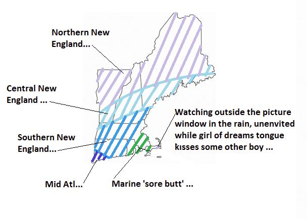
I understand what we are after with these layuts... but using these geodetic boundary -type maps to formulate some sort of weather-related idea of "central" verse "northeast" has always been annoying - For the purpose of what we do in here in the gawk-support group, ranging to professionally disciplined endeavors at NCEP... There is no way NW Middlesex is Northeast, when S of there is Central ? ya know ... We should create a map that's sort of climo around ptype tendencies, for snow enthusiasts... maybe have it overlaid with mean 32 F dashed line(s) where needed... It would probably be arced...
-
Dec (Edit: Jan1/..2 ) multi-faceted ptype mess potential...
Typhoon Tip replied to Typhoon Tip's topic in New England
Yeah... if no one minds... I'd like to swap the title to be Jan1/2 ...this has morphed in timing to be smeared in favor of NYD and over night into Saturday morning, so we should reflect that -