Typhoon Tip
-
Posts
42,349 -
Joined
-
Last visited
Content Type
Profiles
Blogs
Forums
American Weather
Media Demo
Store
Gallery
Everything posted by Typhoon Tip
-
Fwiw - the operational GFS look similar, but it's ensemble mean ( GEPs for that matter, too ) have been trending more coastal. This is the scatter plot range for this sort of early .. long lead outlook/risk assessment.
-
To me that ( bold ) is above median/climate probability ...pattern reshuffle. yeah. There's going to be event(s) 'precipitating' ( haha sue me!) following out of that... Models will wander a bit at this range - duh. Some runs more onto it, then fade...bring it back. ...blah blah. But I think the D7-ish is the first of the plausible scope(s) of interest. As far as cutter versus coastal... I dunno - that's again going to be speculation. Everything is at this range... But with the NAO going away, that does sort of leave room for Lakes cutter. I would look for the N-S component of the larger R-wave amplitude as the PNA index is rising this week. If that emerges with a lot of N and S ...that means that we dig earlier in the trough sequencing with that 130 hour S/W coming through the West... That would tend to signal DTX routing. The Pacific will instruct the future details as to where the ridge and trough axis align, and goes without saying... at D 6 to 8 range that can vary 1,000 naut miles in a single cycle. I mean you hope it doesn't for headache's sake -
-
try not to get bogged down/hopeful based on details - just some friendly advice, for the general reader. The purpose is recognition of certain markers/metrics of large synoptic envelope, those that have parlayed favorably in the past. This is one of those times... How that will manifest in the "giddy" department, ...that's days off. That said, there is no harm in speculation only, as to how details may emerge ...modeling cinema therein support or against...etc. By the way, the GGEM trended at 12z ... really close to coalescing closer to the coast... In fact, that giant open nucleus you see over central and southern NE is a smoking gun for problems resolving at this time range. One run among many... but illustrates that point:
-
Tru - but ... I don't care? I don't. I just like this method because it has worked ...many times in the past, for 'early detection' What actually comes of it? yeah...it could be a siggy coastal storm as I intimated. It could certainly be just a colder - more convincing - pattern. But I am higher confidence that there is a pattern reshuffle on the doorstop here, and it starts entering the picture over the course of the next week. The system on D7 fits that mode-change statistical correlation for storminess. Basically that whole post could be summarized in those two bold statements. However big or fast moving, or whatever aside. So, we'll see.
-
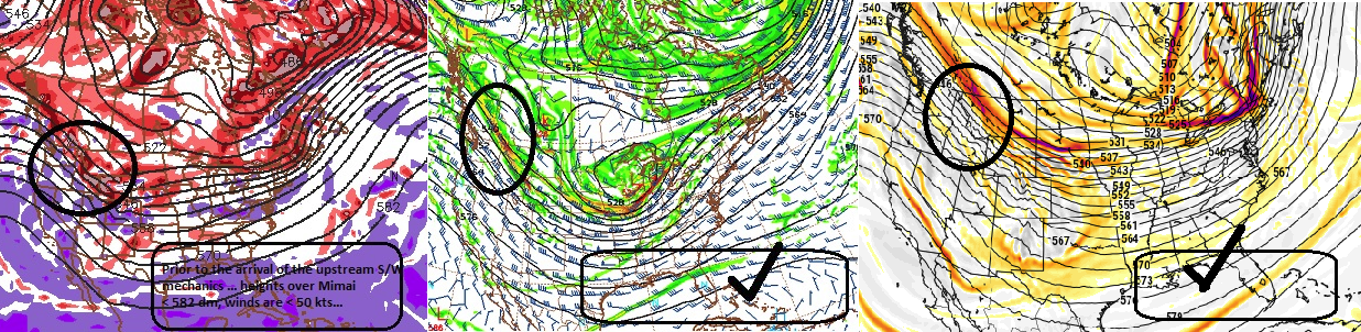
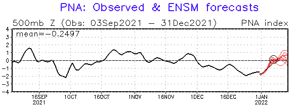
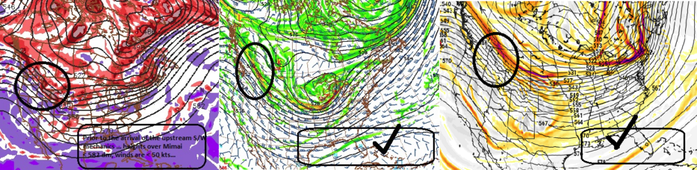
Confidence should be higher for this particular coverage, than any other preceding so far this cold season and time frame for the purposes of early detection. Focus is January 6-7-8 What was was merely zygote yesterday, overnight down right embryonic with an early heartbeat. As the for the specifics of this eastern N/A mid latitude amplification... it would be set to materialize in the D6 to 8 range... more likely centered on D7. SO, there is inherent risk in attempting a deterministic forecast for this love child. Yup but ... this isn't an impregnated crack-whore here. This is well-to do wealthy couple of families with good genetic pedigree, doing an arranged marriage with two early adults that actually find one another attractive - ... i.e., this child's prospects for actually being born are pretty good. Longer analysis: Multi sourced agreement was very zygote yesterday ...as others were/have been commenting. There better 'looks' materializing in each respective model type run cycles, spanning the last day's worth. At the time ( commented on this late in the afternoon ... heavily concerted agreement among the GEFs -based telecon for the -PNA to recover toward neutral. I believe Scott might have also mentioned the GEF improvements ...etc. Last night that become exceptionally pronounced! The EPS at a glance would appear to support this idea in principle, of a -PNA release in lieu of a more seasonal looking PNAP construct to the flow as we end week one and head into week two ( I don't see the EPS numerical equivalent/calculations as I am a cheap douche that doesn't like paying for something that we can all see just by having a clue and looking at the height distributions among the various mass-field domains... but that's just me). The impetus in this show-and-tell is that is a WHOPPER correction event implication there. That is about as concerted agreement among the ensemble system of members as is mathematically possible. The first 7 days, ending roughly on the small annotated circle you see above(right), shows essentially 0 deviation along that very intense rise in the index - I'd almost go so far as to characterize that as a 'whiplash' event - something is snapping massive disruption thru the previously semi-permanent stasis in the Pacific North-American circulation manifold, and that kind of disruption almost has to incur some sort of balancing/restoring event. Commonly referred to 'Archembaultian in following from her science back in the day. Meanwhile, the operational guidance versions are all in what is really for this time range a pretty spectacular agreement regarding the principle components for this early detection. Sorry to emphasize that like I'm yelling ( lol..) I just want this as a learning chance for how these things can sometimes beat/win against the early doubt machine of the typical long lead, model fantasy storm. This one ... mm, isn't that. This aspect above is crucial as we head through the week - we need to see these larger scale concepts gain continuity in the guidance. But therein, they are also rooted ( if not just exquisitely well timed..) within the same frame work of that impressive PNA jolt further above. I've referred to this in the past as the "Miami rule" - I've come to find that it does pretty good as an index finger rule. This is about as detailed as I will get at this range, but as a significant S/W is being ejected through the west, we look to the SE U.S. and adjacent Gulf/Florida skies and off the SE U.S. coast. If the heights are at or above 582 decameters over Miami Florida, and/or the balanced non-interference geostrophic wind is over 50 kts... negative interference is in play... as the S/W in question begins damping and reducing mechanical power as it descends toward the Tennessee Valley. These annoted frames above, show that this is not the case. Which in its self is ...really pretty f'n remarkable considering another avenue of discussion. Bottom line, since this would-be system is emerging as one rooted deeply in a strong statistical correlation (Archambault), with the above PNA mode changes, this significantly weights confidence ... far more so in my perception comparing any other system so far that may have appeared favorable this year. No need going into how well those turned out, huh. As a conceptual aside: I also recall a sentiment I proposed last week or so ...regarding pattern gestation lengths. Seldom do patterns lock for longer than 90 days. The system is inherently too dynamic to all for that to happen, with too many competing forces in Earth's total atmospheric engine to do "Red Spots". In fact, the mean pattern time span, ...as we used to discuss in FAST way back in the day... is about 45 days. Patterns may reload... but they will almost invariable go through a 'reset' or some sort of R' rollback/progression for an interim. Or, the new paradigm sticks and represents a more fundamental change that will in its own right last for several weeks. This PNA mode change appears to be connected to changes in the EAMT - can't recall the Met poster who brought this out last week with some nice animations, but this is suspiciously timed with that, and may in fact be a planetary wave# event.
-
Does seem that way. But I also wonder how common they ever really were? Tempted to say 300 yr mean is 1::4 or 5 but the last 10 yrs have blown up multiple signals regardless.
-
Which is still abysmally mank infested misery outside. The Great Winter Of Zero Redeeming Value. At this rate I’d rather it 50 above normal.
-
Basically … a general shit winter with an interlude or two of tacit favorability La Nina’s are supposed to be front loaded winters. Yet another ENSO climate failure … It’d be really funny if the winter is back loaded or even mid
-
I suspect depth of -PNA trough has more to do with the superposition of the longer term La Niña occurring with a normal intraseasonal pattern forcing from Asia through the Date Line Those would be in a powerfully constructive interference in tandem … The HC expansion is a whole scale base line state of increased(ing) hgts within the deep subtropical latitudes. It doesn’t modulates patterns in the same way as it’s evenly distributed as lower latitude canvas over which these other intermediate (pattern) and longer termed (La Niña) aspects take place. That’s the present papered facets on HC expansion. I have personally advanced hypothesis that its increasing the gradients at mid latitudes during the winters; so in an indirect sense … faster flow can affect Rossby waves distribution and so forth but even if that were the case and that could be proven … it wouldn’t stop what’s going on with a PNA trough now - that’s (again) likely an intraseason pattern constructively interfering with longer term La Niña tendency, two things overwhelming everything else -probably
-
Yeah... it shows the sensitivity - it seems endemic to fast flows to do this. It's almost as though a more standard flow rate is more resistant to change
-
For what it's worth the GEF based telecon spread is cold UNfavorable from the AO/NAO, and given that they share domain space, and appear to be moving in tandem, might be a strengthening argument that they are coupled into the same forcing. That would materialize as a negative height anomaly tending to encompass/ lap over both. My guess is between the NE Canada. However, the PNA ...as others have surmised by graphics, is concertedly entering a modal change from -2 SD with some members even modestly positive by as near as D10. Note, we don't need to have the mode diametric before restoring events begin taking place,... If by indirection, this might be cross-guidance "nodding" ... ( at least ) wrt to some of the Euro products. I'm also not sure the EPO won't pop negative either, given to the EAMT relay way out there. It seems that could happen at any time in the next 2 weeks.
-
Well... compounding factors... There's no one-size-fits-all index controlling the number of inches we're not getting, but are taking LOL But I completely jive with the bold, sure. Any -NAO biased over the western limb of the domain space .. yup, that can overwhelm by compressing the heights south through the Lakes and Mid Atlantic. That will speed up the flow. Remove that and the flow is still fast, though. It has been... regardless of solar, ENSO, PDO ... dogs and cats living together.
-
Well ... we can't think of the Earth system as having a silver bullet factor - like the HC is causing all this, or the La Nina is causing all that... The climate system is an on-going cocktail of influences... some more at times, given the favorable setting to act. That's A B, the compression has been an issue across all winters now going back a decade, the majority of times, and that was regardless of ENSO state.
-
I don't do that. When it comes up...such as Will's ( correct) observation, that there is blocking at high latitudes and the oddities in the results here...etc, then it becomes relevant as any possible aspect of speculation. I don't go out of my way, and I can prove that. I don't really care if folks accept this gunk, or pin it on me...? But "everything" in the above context, is bullshit just the same.
-
Really ... this is entirely the whole package of cause-and-effect circuitry of the Archembault paper. Yup. Status quo means balance, thus rest. Something imposes change to a system, the balance is off ... in order to get back to balance = storm. That's it ... That is why all modes --> modality, regardless of whether it involves NAO this ... PNA that... WPO this ... EPO that.... If these are in stasis, and something disrupts the status quo ... = storm. I'm just entering that the H.A. stuff is applicable to all of nature, really ..certainly to the nature of weather restoring.
-
I remember you and I having this conversation last year, when this HC stuff was young. You were asking me about the 'effects' of it during the respective ENSO climates? I remember speculating that it may be more of dimming factor for El Nino's. The reasoning was entirely intuitive, mind you. HC and it's effect manifold is all still on the discovery table anyway. The papers/climate I've read about it seems to be open to debate... That said, the La Nina is a stronger easterly trade scenario. And HC expansion has an easterly trade mass, regardless. ... So it it is easy to see where I'm going with that. El Nino on the other hand enforces a break-down in the trade momentum... etc etc --> warming waters moving E across the Basin in the generic sense. That would be intrinsically in conflict with said HC momentum/assumption. ( again agian again ..we are juggling 'tendencies', not absolutes - people read this stuff ( if ever lol ...), and tend to think big ).
-
I know this is annoying mantra at this point... but, imho the HC shit is imposing. It manifests as greater gradient --> speed saturation of the flow. Basically then situating blocking over the top, which intrinsically is a wave signal from the N forcing the jets south, means those are competing forces. I think what we are seeing in all this 'destructive/negative interference' is at minimum, partially related to that competition. Just a furthering concept: CC has added 3 to 5 dm to the total integral of the tropical/sub-tropical Walker circulation since 1980 - according to survey/climate papers back in 2018 - can't imagine that's gone the other way since... And that may seem subtle, but it's like with the sun? It's like where .1% dip in total radiative output of old sol, has a big response in the atmosphere here on Earth. There's a relativity to it, because that .1% at the sun's end becomes a rather large issue for a tiny world that is sensitive.
-
Well yeah… I was trying to throw central New England folks a bone. Funny thing is if the Gfs corrects another tick like the one it just did then we’re probably getting ice down to the pike And west of Methuen. lol. Jk
-
Look at how narrow those fields are. Testament to compression I guess This whole b-c passage is kind of like a pseudo H.A. correction event. The lower latitude ridge is really in process of progressing east - so there’s action at synoptic inflection, so to speak. It’s just is getting crowded by the eager trough arriving. One can wonder if the trough slows down just a little bit and timing am I actually open the door for a little bit more of a New Jersey model type low.
-
I still think that’s over baked with that follow up southern trough thing… The thing is … it can happen. Yup but there are more reasons to be suspect of that. Ridging in the southeast is one but the other… How many times have shortwaves been over amplified by the GFS in that time range. It did pay off in the last system remember the euro actually had it no event till 36 hours out even though it turned out to be crap and rain and whatever, GFS it saw it first. I’m really more interested in the lead stuff trending colder like Phinny and I were tracking.
-
I don’t think that southern stream feature has much of a chance frankly unless it ends up correcting much more powerful. Not impossible but less likely perfect reason to have it go ahead and happen where it’s just strong enough lol. Otherwise hgts are so high over adjacent southeast that as a it comes in it’s just going to compress the flow/speed shear will absorb it.
-
Don’t forget the winter between April 11 and June 5th …
-
But isn’t that bad for soil chemistry the following farming season? I thought frozen ground was better for keeping nitrogen closer to the surface… Which would be particularly useful in a year where there’s less snow because snow is the nitrogen fix; so if you have less of it you don’t want it percolating down deep below root levels. It’s one of those things where I kind of understood it but didn’t dig very deep when I read about it in all honesty
-
Plus I wonder … you can also get an initiation of upslope snow happening pretty quick when cold air floods in and pushes a wet airmass up the topography etc. ANAs are mid-level mechanics though where there is still strong jet running parallel to the boundary over pass-through …. pulling moisture back across the boundary interface usually some 8000 feet up. Other aspect to your point is that your higher elevation up there may allow the precipitation actually make it to the ground because a lot of times what’s going on is that the models are not seeing evaporation going on below the fall column under the ANA area so they got fallacious QPF
-
Yeah I’m not convinced we ignore that down into central NE until 72 hrs no. Could end up a longer duration transitional ptype event. I gotta think you’re snowing in NNE above that boundary because that’s pretty cold near by southern QUE/SE Ontario so the thermal gradients would be packed.