Typhoon Tip
-
Posts
43,440 -
Joined
-
Last visited
Content Type
Profiles
Blogs
Forums
American Weather
Media Demo
Store
Gallery
Everything posted by Typhoon Tip
-
It's trending better... The lows surface and aloft are trending more progressive, such that it's grip on the region is less. The impetus of that is that the 'trend' may not be finished. I'm also noticing a trend to be higher in latitude, too. That Euro is two days tops...more like standard month of Anus
-
Yes ... Norways - good call
-
We 'started blooming' those about 10 days ago but they were in no hurry. Took about a week to get to the full splendor. Lilacs opened up and have infantile leaves with embryonic flower pods, and the brambled hodgepodge of neglected shrubbery across the road are all green with small leaflets too. The bigger trees ... only the sugar maples and reds are flowering. But the other maple and oaks think a nuclear holocaust must have happened. just sayn' this for reference as I'm like ... 70 mi due S as the crow dumps on windshield from your location here along Rt 2 in N Ma
-
It'll be interesting to test that... I mean the "gloom" is not showing up too well in the FOUS/NAM grid. There may be a sneaky layer in between the sigma levels given, but the ones given are < 50% RH after 12z... which are 900, 700 and 500 mbs. Thing is, ...we are only 3 weeks from entry into solar max time of year, ...*IF* the moisture layer is that thin, the sun's likely to punch through that ... It'd be that satellite looping where it melts away from west to east toward the coast ... circa 20 ..21 z. Also,.. the onshore flow is very light after 12z too. The momentum/pulsed arrival appears to be Saturday night through dawn. After that, it's 3 kts mid boundary layer flow over Logan ... Granted we are talking the NAM here, but that would imply more variable in the region.
-
Hope springs eternal from the eternally optimistic I guess, but the artistry of that scene for me would be interminably improved if not for that clump of shit looking black mass of ugliness that lines the pathway
-
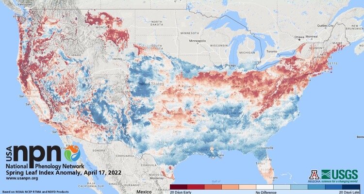
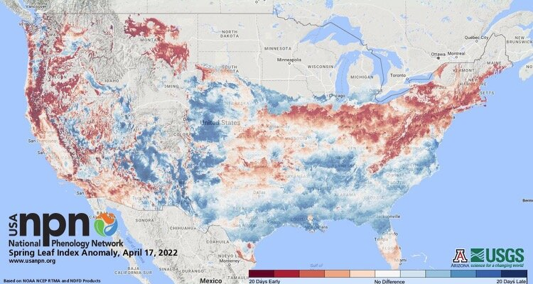
May be some color interpretation differences ... but I don't see many pixels on that chart at that far end of the spectrum. Looks rather mid way ... so 10 give or take? Otherwise, even so yeah .. .not sure how the source - from the USGS if that should matter to anyone - goes about tabulating the data or enough so that an algorithm would paint such a dense, noisy presentation - it's also now 5 days ago since that chart date, but that was as of April 17.
-
this is like a "foliage gradient pattern" this spring.. I've posted this ... several pages ago so won't drub it up ( when no one will look at it or comment anyway - ) but the phenotype anomaly monitoring shows above/early greening going neutral neg central into NNE.
-
well... I wouldn't say that either. The post is that there's hope - not much more for now.
-
Hmmm • La Niña conditions are expected to continue for the next several months, with a third La Niña winter beginning to become a distinct possibility
-
It's edging east in subsequent Euro runs, tho ... I realize that doesn't fit the narrative of casting April to hell and believe me, my sympathies! heh... But just sayin' objectively. Subjectively, I think that trend continues. The reason why is that the flow appears to keep speeding up as late mid range gets nearer. It's like the models are in a rush to seasonal slow down, while not warming it up LOL. anyway - if the flow corrects, that'll probably do two things. Alter the distribution of the NAO ... bump that feature more E.
-
Looks like anyone below ~ 700 f elevation went < 32 last night. Definitely a drainage factor with that surface high cresting directly overhead/thru the area over night. Interestingly ..the 850 mb turned continental prior to dawn, and will be above 0 C across the entire area by mid afternoon. We are not likely to mix the BL to that adiabatic depth, but... 900 is also in the +6 to +4 range ( SW-->NE), over WSW flow and > 70% sun ... Today should have some bangin' diurnal recovery.. I'm wondering if we may even approach 35 F in some cases.
-
"Seems" ... the fabled portrait of the American clay - haha. It would be nice to know what is and isn't actually ahead. Maybe there is a species-specific delay. But the phenotype analysis actually has a premature greening in the general smear fwiw -
-
I'm not very personally confident the Euro's 12z solution will even be there. I realize I spent time opining ( ..or 'whining' either way heh ) about the -NAO retrograding earlier. If the retrograde doesn't happen as quickly as as the previous runs ...that cut-off rhea wheel might end up farther out to sea like the predecessor just did. Note, the feature closing off S of NS D5-7 has gone from nearly right over us, to 1/3 the way across the Atlantic as a three day correction. By the time the D8-10 one is closing off... it may end up corrected E too. Plus, the Euro's alone - there's that... I mean that not that anyone said otherwise. But yeah, as is? oh my god
-
I'm not sure that is a BD front after discretely nerding out over charts. It looks like a warm front from the OV slams to a halt near ALB and just doesn't come any farther E before the ridge collapses and the air mass rolls underneath. It may actually BD farther S down the EC - hah... you know it's bad when we're creating BD air mass in our back yards instead of arrival.
-
has anyone ever taken a technical assessment/eval at Codingame.com ? Wondering what the questions - it'll likely be true/false and multi-choice for database - will be like. Thing is, I'm a notoriously bad exam taker. I could copy and past the correct answers into the correct fields, and I'd pull down a D- ... I'm kinda annoyed they are asking me to do this. They reached out to me for this gig... It's not a headhunter, either - the company did. I come from a certain technology manifold that is similar, but not an exact fit. They know this. So I've been through 3 rounds of interviews ( Zoom), aggregating 4 and half hours worth, and now they send me this tech assessment link at the above url... I'm like WHY! You look me up and waste a day of interviewing to prove I'm not a fit? ... 'Course, I'm just pissy because I hate taking test, too. Still, a- nnoying
-
Ha! ...I think that's in the AMS glossary -
-
this is prolly real stupid but what is 'SA' ?
-
Unlikely ... just like all other years where late blocking occurred, it'll likely break down circa mid May ... sending a heat wave across southern Canada. What happens after has typically been ( for us...) above normal JJA, where the greater anomalies were in the nighttime lows. That happens because the the cT air mass of summer is being charged more and more as a consequence of CC. It's actually happening all over the planet .. if interested. Climate science is showing that the ballast of warming is indeed in the nocturals not falling as far... due to higher WV. The other aspect is singular heat wave events that are > SD than seasonality.. .but as harsh and headlining as those are in big media, they don't add up nearly as much as the slow drip add-in of the night time lows being persistently above normal in just about every direction. Long of the short, expect an early heat wave in late May to mid June, followed by 87/75 much of the way.
-
Oh man... those GEF teleconnectors are just putrid for spring/warm enthusiasts. I was hoping things might correct some but if anything they keep elevating to even more misery if anything. Then... I think back over the last 5 years ..and how at least 2 of them had snow flurries in May. So what's gonna happen with a -2 SD NAO that's retrograding toward the D straight region, while the PNA flips from negative to positive sign? Even if this doesn't produce an interesting late snow ( the most likely result - ) there's nothing about the recent climate patterning/seasonality, combining the present state of the telecon outlook, that looks very promising. mother f'er, how I hate this dumpster geography at this time of year.
-
there's two through D10, tho - In fact, there may be a procession of 'em thru week 2. It's complex ..but subtle change in the total hemispheric circulation mode, from the central Pac, all the way around to Greenland ... is likely to trigger a -NAO eruption. At first it is over the eastern limb of the NAO domain, which is probably why the first closed low that rattles around underneath it...ends up out along 60 W... Just far enough E, we are spared a gruesome Saturday. Then, blocking is retrogrades over a painfully slow 7 day period, ending up over the west limb/Davis Straight... That induces the next stranded wave to rattle around 70 W - the one is the one you're seeing for later next week. But there are in fact, two over the 10 days. The models have been picking up on that total behavior, ens and operational version, for a week - it's likely to happen. 'Sides, as I've opined ( when not bitching about it...) it fits an emerging persistence about springs in general over the last decade, to observe late blocking. Whatever happens, the -NAO is likely to occur and f-up any chance for real pithy warmth. Both the GEFs and EPS ... garland the 70 N region with tendencies for positive height anomalies, while tendency for lower along 40 N, over our side of the hemisphere... right through the first week of May. During that time, the 'correction vector' is pointed at the rhea end of the spectrum. Doesn't mean it will be that way all the time, just that in any situation where the indications look 50/50 ... put money down on the shit side.
-
Wouldn't care to doubt any of that. But what we take what we can get, and if Fri - Mon end up that way, it shows a chicken shit pattern can sometimes come into range more chicken salad. But as far as the next three weeks, it doesn't look good with blocking in the means pearled out along the 70 n region of this side of the hemisphere. If that works out, stretches like Fri/Mon are rarefied.
-
This doesn't look terrible, Friday through next Monday to me... Not looking over the GFS and/or the Euro synoptics. Both park the surface pressure pattern/ridge squarely overhead, with 850 and 925 mb thermal layouts that would easily support low 70s at this time of the solar calendar. Sun would be the only limitation...But +7 at 925 mb in dry partly cloudy is still getting us into the mid 60s. I thought/previously it looked like BD hell but that's not what's being modeled through that period at this point. Stepping back further, this is a classic spring 'omega block'... Every once in a blue moon, that sets up with the ridge right over one's location, with the conjoining a-hole vortexes too far E or W to effect. Could it be, this is the proverbial blue moon? I guess the set up is too transient to be a block, per se.. but through those 4 days it lasts -
-
I'm sure when this April's 'state of the climate' is published later in May, it will be in the top 5 warmest Aprils since chisel and hammer. Yet, this region of the N/A continent will not only be the coldest region relative to that above normal month/planet, it will almost singularly be weighting the average down ... owning 90% of the offset ballast. There is something about springs in the last 10 years, where this continental folding/-NAO domain shit kicks in late, that picks on this region of the globe. Seasonal lapsing ... It's been happening regardless of ENSO this, solar that.. N. Pac this ... over the last decade. I know why it is - I think - but ..no one will read it if it is written, so I won't. That said, it may not mean snow flurries in May, either. But for warm enthusiasts, you're likely not going to see 1976 or 2002 - even though those year's springs were also led by a NINA
-
Why does having a child change one's temperature preference?