

Typhoon Tip
-
Posts
43,440 -
Joined
-
Last visited
Content Type
Profiles
Blogs
Forums
American Weather
Media Demo
Store
Gallery
Everything posted by Typhoon Tip
-
You have to consider the air mass's source-origin ( straw man). Draw a line on a map from about Portsmouth, NH to Willimantic, CT ...anywhere west of that ~ demarcation, a NE wind is not bad or necessarily 'cold' in this scenario. That gradient/trajectory is pulling down from a region exhausted of cold, and is in fact capable of warming under both May sun, and tending to be d-slope. East of that approximate line ... there is more modulation by the ocean...but even here, this air mass is not like an afternoon aggressive sea breeze, where the air temp that's moving west is a direct SST processed air mass and thus reflects the Harbor temps. Long of the short ... despite the onshore look of the gradient through early Wednesday, those interior/west zone will make out for some nice afternoons, as the gradient also gradually eases and the skies get more and more clear. Already markedly improved sky conditions... Morning vis loop suggests it may also evap further (trend) and really just expose us to more sun even today.
-
00z NAM lowered ceiling RH substantially from BOS to ALB tomorrow. < 50% connotes clearing.
-
These are as a result of dry air layers penetrating the rain seeded sounding. Evap cooling off the surface of hydro meteoroids can cause them to freeze. It’s not the same as as a winter sounding. This occurs just about once every spring when large differentials between T and TD … having wet bulb below freezing. I’ve seen it do this as warm as 50 F at the sfc. Light rain with sleet pellets mixed in. Usually it happens at the onset. This now is happening as dry air invading after the fact.
-
Not going to happen either.
-
Still holding a 78 to 88 ( top down) type look from Thur - Monday ... That occurring would certainly be a stark jolt for a region that's pinged a roasting 73 only three times since March. Not sure a buy the Euro's steady diet of BDs Thurs on... Takes risk at this time of year, I know - but it appears to artificially lower maritime heights/bully in, which is a bias for that model in the mid range... That's what causes that to happen.
-
The low is filling as it is also moving S ... Wind dies for both reasons. Tomorrow might be nicer than we've been advertised. Not warm by any measure, but we have broad sky lights opening up here in the interior N of the Pike...a trend that's likely to continue and be more pervasive tomorrow given where all's heading.
-
52 here with occasional breeze but the winds slackening off in the last couple of hours ..albeit slowly. Mowed the lawn, then took to clean up ... raking/thatching, minor landscaping and so forth. Even at 52 was beading sweat at times. It's really the perfect temperature for doing that kind of yard toil - even 70 with sun would be sack sticking, eye stinging, back soup with probably weed toxin welts itching shins and forearms like a pox festival... It's dry and no high sun. Perfect for doing that kind of work. you should get out there -
-
Occasional Thoughts on Climate Change
Typhoon Tip replied to donsutherland1's topic in Climate Change
Not to celebrate it but it is fantastic as an image ... lots like this too around California and the surrounding west..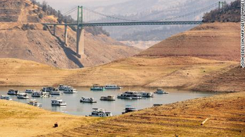
-
A thinning tendency is eroding S through the denser canopy. Showed up at the region doorstep right around 12z ..and looping sat since, you can see it eroding SW through N-E zones. There's still 300 mb milk and mare noodles stringing out over top, but you can see the 700 to 500 mb layer is calving backward - probably that dry air. Models did well to time that.
-
That models is at minimum ... figuratively inventing reasons to eat away at the temperatures at the end of the week. ~120 hour oblong U/A structure, I bet money, is an artificial construct of whatever bs they're doing for controls in the machinery of the Euro. If it's going to all turn out tepidly warm instead of mid 80s, so be it... but the atmosphere has to realize a lot of nuances the Euro appears to spontaneously inject into the synoptics out there. Seldom when a model gets cute D5-7 do the dailies go on to reflect those details. It seems like a scenario where the 4-D 'noise' smoothing isn't working too well. Maybe because the ridge is top heavy and the whole domain is inverted - somehow that turns that off.
-
It's actually really pleasant here today... No shits yet - Ayer pinged 65 ... now 64 with clear air and zip wind. The only detractor is the pal cast with orb sun only dimly visible. But at least it's dry. It's just nice, no more, no less. As the low south passes by we'll freshen up the wind, but I've seen this before ... That wind may not penetrate that far inland. The low is filling as it descends S after 12z tomorrow.. That'll impart 35mph gusts into the city, but by the time you hit Arlington/Waltham, it's lost momentum. Flags are waving, not snapping. Get out toward I90 and there's even calm moments. I'm not sure how pessimistic it really turns out N of the Pike given to winds tending to relax, rain never getting there, for areas W of 95 through tomorrow night.
-
GGEM on board for Thur - Sunday big time reversal in sensible weather... Daily thickness swells from 564 at dawns, to 572 dam, with +14 to 17C at 850s through the period in both guidance, with only convective debris at dawns yielding to lowering ceiling RH before TCU refire in afternoons. ... probably 85 to 88, but 90 not out of the question in the GFS.
-
Ha ... 'little uneasy adding the fore and aft days to that stretch ...just based upon unrelenting persistence to f'up warm signals this spring. But yeah. I like the 16.5 C at 850 mb Saturday 21z as the mean between NYC and y'all central folk up there, with a DPs over 60, and mottled QPF.. It's indicative of TCU fun, too. It's literally, not just figuratively deep summer, right down to the smell of the air - which we haven't even sniffed yet.
-
12z GFS looks like full-on summer, next Friday through Sunday
-
Cat paws if not a mangled 'chute or two in the Poconos tonight...
-
00z GFS says 'late not denied' on warm anomalies finally getting in here ... Late Thursday through the weekend as everyone can see there. 06z GFS, not so much...cancels it out entirely. Two runs, two distinctly different synopsis from Wed on this next week. The models are not really required to be hugely correct at this range - although, they had better be when there's a 959 mb low sitting between Cape May and Cape Cod, with a 1045 mb high N of Maine.... of course! But that 06z GFS never gets the ridge axis to pass through at all.
-
Sunday would be the better of the two. Not sure Saturday if the 300mb RH allows enough solar to offset an onshore flow/ 60 at Portland. The N extent of the U/A diffluence fan is above that latitude, and it's >80% all day tomorrow. 855 -500 is dry... < 50% along the sharp gradient in SNE like you say, but that has upper deck spoilage written all over it. And with E wind of Labrador's blue balls ... good luck with 60 at PWM on tomorrow. But, ...not gonna say it can't. Sometimes these upper ceilings are not handled as well as the main UVM region of the atmosphere beneath.
-
Those that hail from SE zones would be insufferable under that OE band ?
-
Looked to me like the Euro trended S fairly significantly ... Not out of it, no - but doesn't appear to even wet the roads in HFD-PVD at closest pass. I really don't give a shyte about this coastal thing, frankly. I was pretty certain there'd be something smearing east out of the OV over this weekend - it's been on the charts for days and days actually... What's pissin' me off is what the models do with it deep into next week. It's a weak low, but strangely giant only in the spacial metric - enough so to proxy the weather from Florida to Maine... stealing the entire first seasons warm ridge from finally getting these large stemmed deciduous trees to finally leaf out.. - a nnoying. Anyway, another bump like that by the Euro and Sunday ends up turning sunnier. Still likely dealing with an E tube of Labrador fart but we'll see.
-
Right, right... should be a nice dreamy inspiring 56 F down by the water front -
-
It may just be a slow cook ... KFIT and KASH are both at/within 5 of the machine guidance of 70 and 69 respectively. I guess if we make 68 at these sites it's not too bad. Typically on the day like today at this time of year ...this has bust the other direction written all over it - for whatever reason, that won't likely be the case this time. ...while the world continues to put up warmest this that or the other -
-
Two schools on that ... 1 ... The NAM is squarely in the 60 hour window for NW bias with coastals. There are other guidance still S with rain on Saturday, enough to wonder if 06z/12z were just bias runs. 2 ... The climate of this spring has presented a leitmotif in verifying miserable ... relative to all possibilities in play that could/would have allowed for something better. The verification found the worse weather relative to the input. A persistence I am not sure won't just repeat here... Not a very scientific approach - no. But, it's hard to knock consistency.
-
Where's this warm air today ...? It's 11 and 57 here ... It's not doing 70.
-
06z GFS is more sensible with that thing. I think the transition time ... Sunday through next Tues/Wed is too conserved by prior runs. They are/were exaggerating the momentum that ends up in that thing - or just plain exaggerating it's spatial dimension. It lacks too much baroclinic gradients going in, and subsequently is normalizing after the fact. It's probably not as capable as the 00z versions were at menacing an impact so pervasively. It's a tedious difference, but one with huge ramifications for sensible weather: It's either fair and a warming trend vs complete rectal spray out of an exploding whale corpse. One or the other ... hard difference. Can't turn the flow SE at this time of year for any reason and ever have any other outcome than justifying leaving this area of the country out of frustration.
-
As an aside, ... air mass supporting snow May 20th on the 06z GFS... no problem - right? 4th warmest spring in global history - still snowing in New England a mere month before the Solstice. Makes perfect sense. Something I've noticed for years...how it seems NASA's state of the climate publications since the year 2000, ~ 2/3rds of the months ( guesstimate) have a relative bottom out of temperatures if not over New England ... within distance of this region. There's something about how CC is driving the Pacific relay over N/A ... causing the continental folding - like a planetary scaled Kelvin Hemholtz wave. Stronger westerlies lagging later in the years... is going to go N due to corriolis as it encounters the western N/A topographic barrier... After which, the coupling at large scale drives exaggerated compensating mass flow SE into SE Canada. It may not represent on a daily chart - per se ... But it's like an 'implied' systemic vector forcing that expresses sort of insidiously. We end up above normal here, but not as much as other areas of the world per-annum.


