

Typhoon Tip
-
Posts
43,440 -
Joined
-
Last visited
Content Type
Profiles
Blogs
Forums
American Weather
Media Demo
Store
Gallery
Everything posted by Typhoon Tip
-
It does look as though it is running out of momentum, doesn't it. It's still identifiable on hi res vis loop, scouring out the fractal CU.. But it has clearly slowed/begun having trouble getting west of Monadnock-eastern CT elevation axis. I'm not sure if that's dependable the rest of the way, today. Maybe, but the models didn't really do too well with that behavior, with a mid day deceleration taking place like that, with the NAM ( for example) on previous runs showing no hesitation careening it right down into NJ, unabated. One thing I am noticing ... again ( it showed up yesterday but at the time I thought it was just 'noise' in the models), they've closed off the 1016 pressure contour over SE NH/E MA...with actually d(P)'s nearing -2mb farther up toward PWM later in the afternoon. That's telling me that that this initial pulse was not as well back-built as these guidance illustrated on prior runs. Without pressure rises contiguous up the way, the source is cut off... That said, the pressure does begin to rise again near PWM ( up in lower Maine) later this evening. That would likely require a secondary push tonight if that occurs. But these are only 2 mb variances so... 74 here ... temp actually came back 2 degrees. Winds lightened off too. It's actually deliciously pleasant right now.
-
This could have used an air quality alert statement...
-
Yeah you can just sense looking at that, it'll want to fill into the region behind the front as the day gets on ... packing in eventually. I have to say, this is probably the more vivid example of a BD phenomenon in its purest form, I've seen in many years. I may not be qualitatively exactly right about this, but it seems overwhelmingly like our BDs have been more hybridized in character ... Sort of lost in other stuff, or perhaps wimpy in general. This? wow - I mean pollen plowing pulsed gusting. It was really through here like a gust front off a thunderstorm. The delineation in wind direction and in very short order, the temperature response, was just as quick. Also - in that satellite loop abv you can see that line extends out into the ocean by a considerable number of miles. I wonder if that's a subtle marine problem for vessels/'white squall' out in the Bay waters... I mean if your in a small schooner or some prone vessel, and then it leans over from out the blue sharp wind shift/acceleration.
-
Just offering a little perspective on this. It's all a matter of perspective. At this time of your, many are anxious to get on with the new season, to feel summer's exuberance and vitality, the weather-type events that are 'supposed' to come with, and all that jazz. Which at a minimum, the expectation of heat is a part of that. But come late July, when we're pretty fed up with it ...say three or four failed heat waves from now ( 91/95/89.4), and it's become annoying and it's lost it's novelty. The lawns are beige. It'll be a 91 maintenance grind and your out there having to do something in it, ...just how much would you wish at that moment this sort of jolt cold correction would blast through. Yet at the furthering end of the spectrum, when we are damned with a fascinating icing scenario, and risk going to 32.4 and losing the nature's art work, how much as winter enthusiasts we suffer the horror of watching the cold air fail.
-
Time sensy but check out this sat loop - this is fantastic! https://weather.cod.edu/satrad/?parms=local-Rhode_Island-02-24-1-100-1&checked=map&colorbar=undefined
-
Uh ... why are you asking me that? The mean T between PWM and PSM is 57 , overcast and ENE wind... You should wait awhile before yanking that chain - little anxious there LOL I mean the time tables have been outstanding modeled - pretty fantastic actually... This may be the first time I've ever seen one of these bad boys really match so precisely to guidance. 12z NE zones... probably 18z down near HFD... NYC/N NJ by late day/dusk.
-
mm I doubt it... The 3K res may be too much, but this spins the wrong way. lol You're temp is going to fall into the low 50s by dark, most likely. There is a band of clouds settling S, aft of the boundary. That will cap matters alone, but ... I gotta go ahead and suspect that the higher res models having 95+% RH in the BL...portends a pretty solid strata deck with even mist possible. We're not getting out of this...
-
Yeah ..that's usually the case. I've had a personal mantra since about 1993 ... if you see any semblance at all of a BD you go ahead an assume it will be faster and more potent by factors
-
Boundary's like a snow plow, only pollen
-
It may actually be more raw and worse feeling for Boston metro arieas and E/SE Mass, because the air is coming with more oceanic mixing - the peninsula effect ...it'll be cooler. But also, as the layer deepens a little, there is likely to be a genesis of strata mank, so it's not likely to stay 60 -
-
Lol, get ur long pants and light jackets ready.. BD front just passed Boston/Logan location. The temperature went from 82 to 62 in 14 minutes, and the wind is gusting to 33 mph from the ENE. Reality cometh!
-
Once or twice in 10 years I've seen a BD on a three day map...correct in near terms and ultimately hold back to being stationary up in southern Maine. Otherwise, no ... There's a reason for that. It's the lower level resolution of the models, and their limitations in understanding the boundary layer conditions - exactly - as the cold ocean, the mountains west, and the coastal plain ...all interact at the very bottom of the atmosphere. It's fuzzy in that region. Adding to that, cold air by physical law, will always travel under warm air because of its higher specific gravity. So, you put cold air in a fuzzy layer, the models are thus more apt NOT to see it properly... What that all means is ...it is far in a way more likely that a cold BD air mass will be missed, than seen - such if they are seen, the forcing for them must be obscene. A little hyperbole, but just very large. In other words, the uncertainty is always sloped in favor of actually getting them.
-
Mmm not really ... That's coming down along a steep azymuth but not from the NE or E. I mean it's all a silliness anyway - a cold front's a cold front. They go by one's location, one's location gets cold. Front. Nature doesn't care. LOL. It's all stupid... But BDs get a little distinction in that typically fronts move from west to east, .... or in the least have west component embedded in their motion. But BD's really do purely move with east component that deviates their motion from pure N. They can happen anywhere. But this region is particularly prone to them for a few complex reasons - That example you provided has too much west component to be "backing in" - at least from that look. But as an homage to the silliness of it, that front probably is a backdoor event, out in time, further south along the EC. It'll at some point run out of W-E momentum over New England, and then pivots around it's self down over NJ and starts moving SW for PHL/DCA....
-
What does the state of China's cultural have to do with the fact that the U.S.'s is unacceptable and teetering with intolerability - and gunning down children certainly qualifies to anyone sane. Nothing - ..that's the answer. Means nothing to say China is a shitty place, too. 0 logic China can be China all it wants - has 0 bearing on our seeking a societal state that does not do what transpired last week.
-
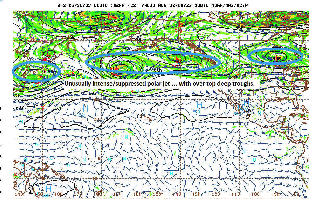
Wednesday may be a rock-bottom day. wow at the shear magnitude of that gloom - 12z NAM has Logan 48 or so Wednesday morning at 8 am under putrid gray skies. Really only gets to about 53 there before those strata rains come in toward dusk. Not sure how far inland that appeal claims ....but, seeing as the boundary clearly surpasses NYC's latitude...with sharp temp cuts upon NE wind shift around 8 pm tomorrow night, this is intending to inundate. Even ALB sees the dense Labradorian miasm spill west of the Berks/Greens, and all locations have problems with cloud layering and trapped/isolated cold in the regions Wed night, while strata rains pass through. Maybe we can at least get an 1" in the tills... This is a highly unusual total hemispheric look through these first 10 days. -AO has become an overwhelmingly dominant signal in the guidance. It gets very complex, but the suppression south of the westerlies, around the entire northern Hemisphere, as is portrayed in all ens some sources/means therein, and is triggering high jet velocities to weirdly south latitudes. That mechanically induces R-wave structures, a behavior that is lagging unusually deeply into the climate season, when they are typically breaking down. As above, the Pacific has an usual 'firehose' jet configuration coming into the west coast with a very vast trough over the top/embedded nadirs... Normally, that would send heights higher over mid latitude of N/A but we are not seeing that happen. The blocking at 60 N is forcing the main westerlies jet S, keeping modest negative anomalies across the expanse of the mid latitude continent, instead. It's just not very summer like. That Pacific above looks like a late October or early November circulation construct, with onset velocities --> R-wave coherency.
-
Yeah, I haven't looked at the soundings, but guidance rip-read looks like a standard good ole fashioned BD the way the majority. ....Rudely butting in.
-
I've lived in the region for 35 years give or take ... I'm inclined to agree that rarely do they bang their way in - just based upon anecdotal experience. However, there have been exceptions. One notable one ( Ryan out in CT has posted rad and write-ups about it) was a fascinating supercell that developed on the BD boundary out over western Mass.. It traversed over the Springfield area, with large hail, then continued to move almost due S bringing large hail accounts through the state of CT. Gulf balls accumulating in gutters to curb height - but I also write fiction as a hobby so that part may be embellished some LOL. I do specifically recall lots of damage reports to windows/automobiles, though. The hail was damaging. I remember the event vividly from afar. I was a student up at UML. We cased that out and got some lecture efforts out of the deal. I remember the radar of the time had DBZ's ... 75 or something like they turned the dish around and zapped its self. Huge returns... very deep in the atmosphere. 45+ K tops on the over shooting domes easily. That boundary cut off a high 90s heat chance for eastern areas, btw. I'm just musing the past occurrence here. I don't know what's going to take place tomorrow...probably just a conversion into low ceiling doom, with indoor lighting turning on by mid afternoon over eastern SNE.
-
Looks like it slams back screen doors, snapping flags and knocking 14 F off your temps in the first 1/2 hour of passage ~2 pm on Tuesday. ..Actually where you are it may be less pulsed or noticeable like that...but a ENE breeze over the canopy and noticeably cooler during that time frame, nonetheless. NYC by dusk.. Up here, we're done by 9 am ... Worcester by 10am. Wed morning, everyone dawns under slate gray Labradorian vomit in an unsettling 50s chill. But, you'll at least partially break out where you are circa late morning, and probably still make the low 70s that day. So not too bad. As for eastern SNE, they're persecuted until the mid week main frontal thrust just resets the whole mess and we start over, synoptically. That cinema or something similar is our regional destiny. Hell, if you look at the GGEM ? In principle, there's some semblance of a Miller B type low ... Blocking in eastern Canada, stops the Lakes low, and a portion of its mechanics shears off underneath, and a weakly responding low over upstate NY relocates/develops along and E of Long Island. That's Miller B... Acceptance of a stolen summer week and just setting sights on the longer range ... which ironically, looks uninspired and boring, is our reality. Anything else is fake news .
-
Get everybody out there for a wondrous spectacle of natures awe to at last gawk at their own deaths oops
-
Can you imagine if a dday meteor was hidden in the awe inspiring oohs and ahh … Then it’s like ooh ahh whoa oh ah um hey-uh SHIIIIIT !
-
That BD air mass is really shallow, too. It's looking like some kind of freak set up where even for BD physics, this thing may get all the way down to the Del Marva no more than 2,000 or even 1800' along a floor slab of air. Look at the pressure contours carefully and it can't even spill over the White Mountain cordillera - it's not even as deep as the mean altitude of the topographic divide. That's what the NAM doing anyway. It's possible this is trying to thin in the guidance... The Euro looks like it waits until 15z or even noon on Tuesday to really momentum the boundary through Worcester, continuing along a trend to slow it. It matters for convection and of course temperature distribution. It's also overrunning strobe lightning over NNE as the flow hooks rich heat over top/overrunning
-
Unstable hemispheric scale - We see there is a suspect TS astride the SE coast, otherwise, it's a four nodal trough/ridge arena over eastern Canada and the lower Maritime, which looks reasonably balanced... But, this massive L/W trough from the Date Line to California out over the Pacific punching into the Pac NW. It's unbalanced. There's more negative in the integral than positive, just eye-balling that is obvious. Things will necessarily balance better than that. Either the trough in the Pac weakens...or the ridging at mid latitudes balloons in the E. Could be a panel away from moving into that look, too
-
Man ... on the 1 to 10 UV index that's gotta be about an 11 out there
-
That is interesting... Like Chris' just said, convection passing SE through Maine and the BD fans back SW as it's leaving. Looking at the synoptics more discretely my self, it appears the BD's position in time - on this run anyway ... - is very sensitive to those convective responses/forcing actually taking place. There's actually two accelerations in the BD from convection. The first being the one he noted, but between 18 and 21 Z there appears to be another convection burst from mid Whites' to Coastal NH, and the outflow then nudges the boundary even further SW. That can all certainly happen in a vacuum of any other considerations, but ... those convective aspects have to verify. I was also looking at the LGA and ALB on the grids and those locatons are in the low to perhaps mid 90s while Boston is 54 F by 21z Tuesday on this NAM run. 40 to 45 F spreads is getting excessive even for a BD, this late in the year. I've seen that extremeness during April... It's almost June though.
-
I was wondering about maybe a 3 to 6am MCS, runnin' SE down the roller coaster. showers/storms maybe more organized, just not well handled in the runs - like. Eastern sections are doomed - maybe we can get some entertainment first.


