

Typhoon Tip
-
Posts
43,440 -
Joined
-
Last visited
Content Type
Profiles
Blogs
Forums
American Weather
Media Demo
Store
Gallery
Everything posted by Typhoon Tip
-
huh... I guess that storm took FIT off line?
-
I know - I get it. and truth be told, in the '2 possibilities' scenarios, I've noticed the hot one seldom gets the call ha
-
Right right ... already can see it it with the blazing hot vortex being jammed in by the GFS.
-
... and I can remember so many summers when 95 was just out of reach. 94 twice...92 a dozen times and lots of 88s.. That kind of summer can even be above average if the 86's are heavy loaded and the nights are mild. I think this is a special event. It's interesting - how does it compare to that heat around 20th-26th of July. I think that whole week was above 90 in more so in the interior, and Logan was tainted but ... I can't recall the dailies. Logan did pop 100's cherry on that Sunday
-
It's an interesting argument whether this thing is acting like a BD or a FD. PWM was 91 when the wind abruptly flipped from W to NNE to E spanning a half hour. They're under 70 now. Satellite looks like the boundary is extending W-E cutting through the heart of CNE ...making steady progress S. Suggests that as this continues to press S against the will of the ridge ... locations will likely spend five minutes with a N flow and then it kicks around to the ENE. I should add ...for those along the NH/MA coasts... I don't know if inland stays more NW or whatever. man..in the meantime, sun is back out in rage since the rain and it's 86/76 ... Not sure if the 96/72 before the wimp thunder was better or worse
-
I think that's gonna be a 99 today .. just sayn' It depends how the C term is rounded. the 2:05 ob arrived 37 C. The previous 1:54 was 36.1 which gave the 98 value after conversion. Logically, do the round decimal up regardless of range? I dunno.. But if 36.1 somehow rounded to 37 - that is catastrophically stupid policy.
-
They'll round it... The ASOS was 37 as reported at both Iowa State and NWS GRR's interface, so that works out to 98.6 and should round up -
-
Logan made 98 ... That's prolly gonna do it as they're about 10 minutes away from TCU field with undercutting outflow... Probably a gusty shower too... This stuff went by here with insidiously dark scary skies that produced 20 mph winds and light sideways rains with gentle thunder. Weird. Sun is out now. Much cooler... it was 96 prior and it's 78 now. I mean 78/75 ... but baby steps.
-
Went from 90 to 39 in 1998 on March 31 over the Merrimack Valley/UML ... That was the Michael Jordan of BD fronts - Another epic one was back in 2002, when I worked a gig at the 900 block across from BU on Comm Ave in Boston. It was 94 with scattered TCU casting shadows over the city sky line at 1pm; it was 45 at 5pm, with slate ceilings and mist particles when I left the office.. This is a short 2nd to the Michael Jordan BD above... It's not 'liked' - haha.. but one can appreciate the power. That's what I mean by spring... PF is right though..I've seen some interesting icing gradients in like Novie or Dec, when it's 28 F in ageo drain in S NH but it's nearing 60 at HFD. Autumn is the other season more typical.
-
I think that's more of a pre-frontal DP sweep ... ( but what's the difference -right?) But if WPC's got any clue ( not sure ) the boundary is still draped through NY - N VT. Looks like I got a cluster of heavy showers racing down Rt 2 here. There's a visible wind shift subtending to SE NY from that, but it is moving way faster than the synoptic features really can - so I think maybe DPs tank behind that. Not an uncommon aspect to have DPs run for their lives when a cfront's coming.
-
Incidentally ... it looks like the BD as 're'manifested and is trying to move SW again... It's really more evident out in the GOM, with wave-form strata along the leading edge... but I wonder if that is attempting to sneak in prior to the front door for coastal NH
-
I think it more apt to say it is a wild gradient for August ? not trying to tamp down your expression - it is an impressive gradient, regardless. But that is actually pretty common in spring around here - "down here" may be more apropos. Like, I've seen the 40 F differences across even short ranges, between Lawrence Massachusetts, and Hartford CT on some hapless screen door slammin' nonsuspecting day in May, many ... many times. In fact, ALB at 83 while it is 38 F at the end of April's - I think I've seen that at least a handful over the decades. Not sure what the return rate for butt boning BD "extremes" are, as opposed to just the standard dildo ..but I know that 30 F variance between HFD and BOS is rudely fairly common.
-
95 BOS ? if so we have a winner!
-
I'm tentatively more hopeful moving forward through mid month. Regime change that looks to have more wet opportunities -we'll see. But if we do succeed a deep layer subtropical sourced connection up the EC ... it would be a neat trick to get through that without rain chances. Even if no organized QPF surges, the lower heights SW while we transport warm humid air N, would likely cause locally corrective downpours with more total areal coverage. Except for Tolland of course.... Could be a Cat 3 hurricane hooking E of Willamantic and Tolland puts up 0.00
-
Despite the panicky morning cloud patterning... Logan's 14:54 93 is two ahead of yesterday at that same time. Wow... Just two more and they bump 1911 to 3rd place for consecutive -
-
I opined the same over the last couple of days...
-
Could indeed be the beginnings of the seasonal "pre-lapsing" phenomenon. I'm hands-throwing expecting a synoptic -scaled October snow potential, or at minimum an atmosphere capable of hosting one ... Folks might have noticed an emerging leitmotif yup... I think this for the time being is more of an App. stalled trough that decays into a shear axis spanning these next 7 to 10 days. So probably more like S of SSW coastal DP flow. But the "act" initially of how the atmosphere is putting us into this immediate transition, yeah it does smack of what you're implying like an early suggestion of intent LOL.
-
They'll be in a pub with tall boys this afternoon then late or unusually quiet tomorrow morning with hang-overs. I was on house-painting crews back in the day ... like waay back there - 20 something's - and we didn't "waste" a rain or heat free pass afternoon. No way - woo hoo.
-
Just from orbit ...I don't know how easy it is even see 80. I mean the climate numbers show that's rare, but I wonder if some of that is just Earth. I mean, comparing other hot regions across the continent... outside of the SW, it seems even in Oklahoma during some of those heat blasts from earlier this summer, they were getting down to 81 ... 106/70 or something whack and then 81/75 at 6am the next morning... back to 105 I suspect it's just hard to do that around here and we chasing something that's even less likely observed than the elusive 100 F high.
-
I was wondering if in addition to frontal cloud capping ( at night ..) there is also some WC compression ahead of the boundary that assists, too. But of the two, probably the ceiling factor is the more directly measurable -
-
it doesn't help that there's a forecaster that lurks in that office that loves him/herself some colder adjectives, having [apparently ] lesser reasons required to get there LOL "Unseasonably chilly" - let's let the still potent, < 15th August sun work through a clearing from a 65 platform? I think it will be cooler - it'll be interesting to see how much so. Like "seasonably cool" is a kind of reserved turn of phrase for the way this looks that is available to the forecast vernacular. I suppose in his defense...it's denser clouds - not just summit capping - just N of the region over SW QUE so if that evolves in and you upslope... yeah. But right now it looks like sun is winning on the hi res loops.
-
The sun's doing it's magic... The skies are opened up considerably over the last hour - as mentioned might be possible. Still lagging across southern VT/NH - they're hillier terrain likely helping that, as those clouds appear like standing wave-form on the looping sat. It may just take long for to overcome. But the temps are responding very quickly. BED is actually 5 ahead of yesterday at the same hour... 83 vs 88. 88/73 but I haven't compared to other sources for rounding nuances. Doesn't matter. Point's made.
-
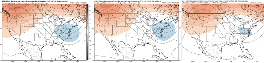
Soo... we're on the doorstop of a coherent regime change again. This one will be fully integrated. From top down and bottom up, it will be definitive. This trough careening along the 50th parallel of southern Canada, turns right as it nears 90 W ... From there, really plumbs down the 80 longitude line. By 200 hrs, the EPS/GEFS/GEPs ... other than very minor idiosyncrasies , these sources are remarkable similar - both in this scalar presentation below, but as that ~ time range comes and goes in their respective cinemas. A-priori experience, combined with climatology, ...tells me this period may be evolving into a "Bahama Blue" pattern. Defined by a coastal parallel flow, they may last a week. What happens is, the summer polar jet reaches it's highest latitude, and that leaves the region beneath in a quasi stationary tug-o-war between WAR exerting west, and this trough above.. - which actually in the process of retrograding toward 90 W. That situates the Eastern Seaboard in a regime featuring deep subtropical air mass training up via a conveyor that straddles the coast. On a personal note...that is one of my favorite pattern types. Days are steamy warm, but seldom big heat. More of the 86/76 variety. The sky-scapes can be a cloud geek's paradise, with topaz blue, adorned by bright white towering CU streets - just like a Bahamian sky might imagine... These will be narrow, fast moving, and can bring very heavy, albeit very brief downpours and then the sun reappears mere moments later. The temp and DP don't seem to move much. This type of regime has only set up maybe 10 times in 30 years ...but, I've seen variations similar to it. It's not either or. I've always wondered... what that would be like if a Cat 4 hurricane was nearing the SE Bahamas during. But alas... in my decades on this world I have never seen that happen... A flawless non deviating conveyor from Nassau to Mt Washington would constructively lend to a high confidence major impact with very limited dispersive solutions to offer any reasons for distraction. I don't know why - is there something about that circulation type that is inconsistent with general TC development/maintenance. Maybe in establishing one, physically makes the other less likely. Anyway... not sure bona fide BB pattern sets up ..but this above looks to match past observation that eventually clicked into place. There are likely individual members that go into the means above, showing more more parallel flow from the S along the EC. We'll see if it works out.. But either way, the era of the western heat expulsion into a flat trough with arid continental flow, transporting transparent CB ..otherwise, high heat, is on its way out.
-
Today may break the 95+ Logan streak, based upon early morning hi res satellite loop. We can't do it without more sun - obviously. I've seen hot weather encased below a cloud deck before but that's usually 88 when that happens. To get to and sustain 95+ spanning an afternoon, I strain to envision any circumstance where that is even possible in this region, when wanly lit by faux shadow insolation. Not impossible yet... it's early. The next hour will be critical. And as the sun rises higher it may normalize the RH that's trapped in that 750 mb layer up there... - if an air mass could ever bounce, this is definitely that type of air mass. So we'll see.. CT? no problem - their doing it. In fact, the same hi res loop shows just what I was talking about, and as the sun is climbing it appears to coincide with their sky trends.
-
I thought yesterday's morning low also was a nuanced butt-bang at that location because of the thunderstorm that rolled through 7:30 the previous evening... If that hadn't happened, that was definitely a candidate overnight for lofty low. It's been a record breaking journey that still managed to get nicked... I guess most heat waves are taxed some how some way, at this latitude and continental/geographic circumstance, either way.


