

Typhoon Tip
-
Posts
43,417 -
Joined
-
Last visited
Content Type
Profiles
Blogs
Forums
American Weather
Media Demo
Store
Gallery
Everything posted by Typhoon Tip
-
Guys there is a semi permanent warm pool there that’s emerged over the last decade that’s been shown to resist forcing by either the ENSOs, or seasonal wind stressing.
-
The “looking stellar” aspect of November (than waning out ) is kind of really what’s been going on as part of the climate change signal, with the folding hemisphere/early meridional expression stuff that’s being papered. … said papers being mathematical. As we get into December January February the hemisphere reaches its highest compressed state so the wind velocity in the interface between the Farrell and Hadley cells (steepest mean) reach their seasonal strongest… And that stretches the x-coordinate —>reducing planetary wave numbers …. which tends to pancake or offset rather, the meridional autumn… I was snarky last page… But in a more levelheaded approach I really don’t have a good feeling about this winter as behaving much different than the last several - which really all have kind of taken us through that journey every year with early blocks and high convoluted flow types tending to end up being fast and more “sheery “ I do acknowledge some caveat emptors, however. … willing to see how it plays out One, still not completely sold we’re not gonna have some kind of interference with normal stratospheric chemistry —> thermal disruptions due to volcanism over the last year. How and or if that even does so is available to question. I haven’t found any specific empirical evidence that the stratosphere was infused but who knows… Two, I’m also curious about the GRB that just took place - deep field astrophysical phenomenon. Though it was 2.5 billion light years away this actually set records for the most intense x-ray and cosmic ray burst ever recorded - not sure if that distinction is relative to that distance scale. But that’s what’s being reported. There was a defined ionospheric modulation when that event swept through our solar system. It’s long but known that sudden stratospheric warming events modulate TEC from the bottom up … Strong enough GRB event might “cleanse” some ozone population out if the PV column high up in the stratosphere anyway …
-
Once November hits I throw in the towel on warmth though… Mostly it’s just knowing that it’s inevitable. I mean you’re going through the solar nadir over those next three months so there’s no use in fighting it lol. I like my winters frontloaded… steady diet of unusual cold and sustained, and dappled with surpassing significant snow events from about November 5 through February 5th … Then, equally as “realistic” … it’s 80 to 101 with stratospheric hard on convection towers until the following 3-strike EC ‘cane season. … totally could happen dude.. No but really front loaders are unfortunately rare. 1995 blah blah was king … but there are some other decent ones. Like those great Decembers back in the aughts, ‘07 and ‘08 and ‘10. There’s probably others going all the way back that at least get you to a C+ grade for early expression. But by in large the heft of all of them suggests we have to wait until after Christmas. And now with cc mucking around with stuff who knows how that’s going to distribute things
-
“Noooo winter for you … ONE YEAR!”
-
Mmm .. wondering when this either a … breaks toward a more seasonal warm anomaly -or- b … really commits to the more ominously near/at historic anomaly it seems tempted to go toward. This two weeks reminds me somewhat of late Oct thru the first 10 days of Nov 2020 … An early meridian flow/cold signal sloshed the other way. The cold even produced yet another in the growing numbers of Oct snow events nearing Halloween. Week later …historic warmth nearing or exceeding of 80 as late as the 10th … really surpassing the Indian Summer mystique It was actually an extraordinary “behaviorally significant series” … unsung do to the Pandemic’s capturing attention. Do people recall the 2,500 pg thread ? - don’t remind us … yuck. So anyway we’re not gonna get a snow event out of the trough side of it this time but we are doing in principle similar kind of large scale sloshing. Also… wondering if that Euro’s meandering thing astride the EC out there might take on some phase transition ?
-
Could actually end up exceptionally warm next weekend if that surface +PP escaping E can reorient itself for more continental conveyor. models are doing what they typically do in the spring with an early Ridge signal… They send the sfc high east north east of Boston such that we spend the entire ridge with a chilly stolen East flow
-
Terminating planetary waves at high latitude/altitude (basically the end game of WAA..) triggers PV perturbations. But the two other factors play an important role there, too: the wave number at mid latitudes is one - A lower number implies more zonal bias limiting merdional transport. The other being chemistry in the trapped PV as summer wanes to autumn. The latter is robustly enough correlated to UV/solar as those WL break up ozone. Ozone is thermally conductive and when WAA plumes interact arriving via wave advection slowing the wind velocities …triggers the warm burst/intrusion - the two are positive feed back and the PV fractures. That’s as it relates to SSW. The reason I’m mentioning this stuff is because there are recent studies/mathematical models showing that as the polar field is warming faster than the rest of the planet there’s a tendency for the Vortx to break down with more meridional structures emerging so it’s kind of hard to parse out what is caused by just fluid mechanics versus how much is that really EP originating out of the subtropics. Those seem to be disparate mechanism? Yeah I guess either way the culprit in the discussion is the A the G and the W regardless.
-
70 here
-
I'll betcha 50 bucks I'll be more right than wrong, ...even after "subjective review" tries to refute what is obvious, too - Climate change is affecting winter. ..badly. Winter season forecasters are not adapting to that, or enough, either way. The way it is affecting is it is causing surplus of gradient, regardless of ENSO. Regardless of polar index modes. In fact, the later appears to only add to it when those negative modes happen to be offloading over on our side of the N. hemisphere. Heights from Old Mexico to southern GA ... tend to stay 3-5 dm higher than the previous 300 years of climate inference. These are reproducing observations spanning 10 years at this point - other than outlier like 2015 Feb...which spikes along curves is also part of the business. Sometimes persistence is a forecaster's friend. Knowing when 'she wants to break up with you' ? That's another story - eventually, they all break your heart. But that's the problem... you're not getting pattern persistence in winters. We've been seeing disruptions in winter pattern footprints - particularly in one regard: very hard to maintain a pattern bias. Mass field changes occurring in short duration time spans. That stochastic aspect at large scales is causing a storm in January ( yay!) to be a week near 70 if not historic 80 in Februaries. Snow in October... with 78 F high temperatures on May 15 with hydrostatic heights of 538 dam! ( that's a weirdly odd, that synoptic combination of metrics). The fact that our mix event flop vector appears to now be wet, not white... Combinations of a varied spectrum of observational oddities, from sensible backyard, to more pan-dimensional/super-synoptic, can't be satisfied using the inferences that are still employed from the previous more stable climate - before the hockey stick got underway. But I don't put out seasonal forecasts... I wouldn't dare in a public venue like the Internet weather-based social forum, particularly now, when the winters are being affected by a warming world - ooh sign me up for that vitriol! The convention of "stellar attention to objective reasoning and acceptance" that goes on here isn't really very conducive. Plus, none of this means we can't have a better year, or even redux a 2015 something... It's a matter of said objectivity merely knowing the odds of doing that any given year ... is going down We'll either be below normal snow and above normal temperatures. Or ... we'll bootleg our way to normal snow from a lucky coastal and windex events, with a smattering of front enders that switch to 33 rain instead of icing... with temperatures still finding a way to be above normal if by decimals.
-
As far as it's 'believability' ... there is a reasonable coherent -EPO puse, albeit lower resonance, up there NW Canada toward the end of this next week. -EPO entries do send a reasonably good fit to lower heights west of Chicago, first, anyway. But the "lower" pulsed -EPO at this time of year... mm. It may be too weak to instruct an eventual cold load across N/A on whole as is in the trends ... So I'm imagining we may end up triggering a pattern reversal that sort of stalls, instead. Leaving us in some sort of more or less Nov 2020 look.
-
The modeled larger synoptic evolution, as we head into week 2, is beginning to remind me of a similar evolution that took place between about October 26 through November 11, 2020. Not an exact analog, but bears a lot of similarity nonetheless. I'd even caution, the signal may merely be fought by biases in either the Euro or American sources, in the present model trends - both of which would tend to damp the scale/dimensions of eastern N/A mid latitude ridging at a D8 - 13 range as their normal tendencies. Long words for, 'this could smooth toward a warmer episode.' It's a specter that's been in that time range now for like 4 or 5 days ...really since it first came over the outer temporal horizon of the guidance, and as we get closer...if it started to look more like this ... .... I would not be surprised.
-
I wonder if this will be the first winter in history, in which 70 F was reported at least once during all three months of Dec, Jan, and Feb. ...then of course we can't touch 40 in March... but wouldn't that be hoot.
-
Let’s set some late heat records after an (at least) elevation snow next week. Ha
-
GFS went quite warm looking in the extended
-
Jesus Christ what the hell does somebody have to say in that particular subforum to get banned. Was it from Darth Sith’s heart.
-
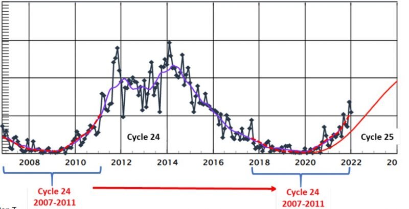
Yeah what I was talking about with the last two solar cycles being in a 23 year nadir is nicely demonstrated there.
-
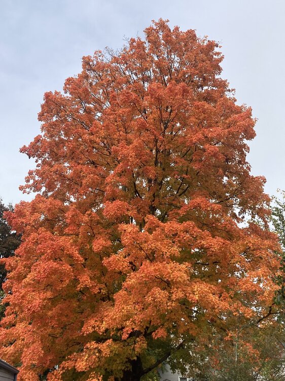
Sky’s day glow. Sun orb dim viz. Dead calm. 63. If the sun actually comes more fully out it’s gonna be actually spectacular with the colors out there
-
In an unrelated observation I don’t think I’ve ever seen my lawn look this beautifully green and pure in essence of that particular color tone in the 10 years I’ve been associated to this property – and that’s amazing considering two months ago in the height if all the drought futility
-
Yeah this part of interior northeastern mass rarely experiences meaningful wind in a southerly gale scenario - or results least. Nashoba “Valley“ so much of it glides right over the top the friction inversion. Despite being in the low 60s ( one might think at this time of year that would be warm enough to mix ) all night there wasn’t one audible gust over the rooftops.
-
Fwiw -
-
Right and so if we hang up the AO in a negative state this winter that would be a breakdown in that correlation. But none of theses are 1::1. duh.
-
Interesting… And just adding to the conjecture – in keeping with the threads title. But it’s funny how we’re in an era ( I mean like over a decade in length ) where these longer-termed, broader scaled teleconnectors seem to correlate less obviously, at times failing coherence… It’s been occurring greater frequency than their mutual correlation coefficients What I mean by that is… ex: the AOs meander away from QBO correlation. Or these extended span of times during winters whence the apparent circulation mode of the westerlies decoupled from the ENSO state. Etc. Pretty sure there is a multi decadal AO that follows the solar cycle – seldom do I hear it discussed in here but the correlation is out there … I’ve seen it graphed and written. It’s positive, such that when the solar is down the AOs tend negative and vice versa. We’ve definitely been down in a solar extending along … I think it’s a 23 year oscillation… The 11 year mins were embedded in that 2ndary differential … such that they were more min than normal min () if that makes any sense. Yet since 2000 the sign of the northern annular mode has averaged positive? that might be a long winded bad example lol But it also seems a lot of negative AOs failed to deliver cold, as an after thought so I guess the overarching theme to this whole thing is that it’s adding headaches to using linear correlations to project what the indexes may do based on historical inferences and analogs, because the emerging hard-to-ignore unstable domain borrows from confidence
-
Word
-
Do you think that might’ve been a little bit of terrain enhanced? The wind trajectories were sort of SSE pretty much thru the 700 mbar. Maybe not appreciably strong but that was a pretty high pwat air mass being humped over the terrain. Ha Kind of gross but where it humps it dumps
-
So it looks like if anything the models were too wet? I didn’t pay too close attention to this because it didn’t look that extraordinary to me. I mean the deep pinwheel over the great lakes/associated trough is for the time being sort of stationary while trying to send this lead side frontal construct through us… I mean the dynamics and mechanics were what they were but it seem like you weren’t really differentiating the field enough for it to be an extreme event– that’s just sort of a canvas for this. Admittedly with shame… I looked at the NAM FOUS once we were inside of 60 hours at ALB/LGA/BOS. As a quick and dirty technique I’ll just average the triangulum between those points off the gridded QPF. I don’t recall seeing values very much north of 2“. I mean obviously that is a crude method in today’s era of reasonably accurate meso analysis at less than 40 hours that can expose embedded heavier activity etc whatever …basically this was a slow moving warm conveyor transporting saturable air under attenuating mid-level mechanics… That synoptic appeal combine with those grid numbers was good enough for me


