

Typhoon Tip
-
Posts
43,417 -
Joined
-
Last visited
Content Type
Profiles
Blogs
Forums
American Weather
Media Demo
Store
Gallery
Everything posted by Typhoon Tip
-
We take that ... It's marginal and at this range, it is even money. After having passed through a dreadfully awful circumstance by then, where very little (is likely) happened ( although the 2nd refuses to completely disappear and keeps sort of trying - ) at all, uncertainty is a better companion then no love. That event is happening more from the polar branch of the westerlies as a Pac delivered impulse, ...perhaps crucially, after the compression of that TPV has rolled out and left. Once that happens, that opens the door to better logistical chances.
-
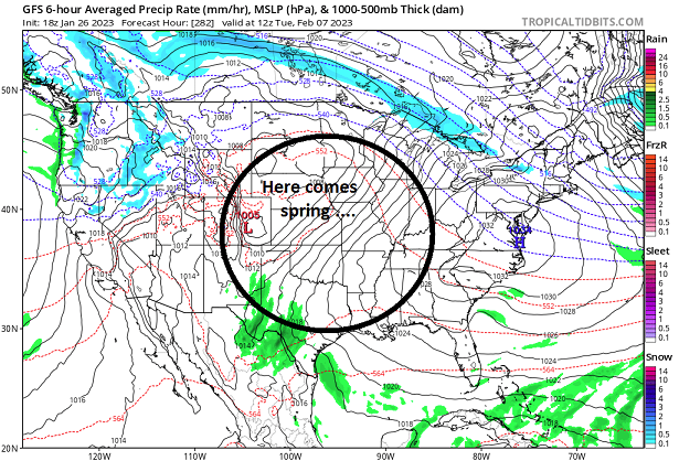
This deep TPV event wanes pretty fast out there between the 3rd and the 5th of February. Towards the end of that transition period, the GFS ejects at wave into the E. That is not an "as bad" look, because the elephant ass has left the trampoline arena, allowing other aspects to dent the flow ... ( heh, kind of hung up on that metaphor lately I admit LOL ) Anyway, I really feel pretty confident that this pattern change has arrived, and much to our collective chagrin? ...it is abysmal. Deal - I mean, really... .01 QPF spanning 10 days of the GGEM model ( and the Euro wasn't far behind). The rain shadow of the Andes is one of if not the most formidable dry damned places on Earth, and that region gets that much from dew/frost condensation. We're attempting to pull off, at mid latitude N/A during the stormiest climate time of the winter season mind you ..., competitive results with the Andean rain shadow. ...astoundingly bad... really - So there's some hyperbole in that above. In essence? it's certainly fair enough. I really feel we need to get through this cold plume variant pattern and the elephant before much is going to take place. This predicament synopsis is wholly prohibitive.
-
If the Euro and some of these other guidance type/cycles are right about next Friday night I'd suggest you do so with ease .. Hm, it's possible that is a windier scenario holds it above the current 2-meter outlook. It doesn't stick around, either. The air mass comes in sort of Montreal Express, and then the high pressure quickly moves east and the wind just veers right back around from the SW in a lot of these depictions ... Considering the standard 10% reduction on amplitude for cold air at this range, combined with wind motion? may hold it 1F at 3 am that night in reality Right now the 2-meter is about -10F along Rt 2. we'll see
-
Yet...should be able to set some personal record drive distances in -10 F lol
-
Pretty much ... ...while fighting the tendency to be less than objective about that. lol - it's hard.
-
Well ..heh. I guess it's a subjective vs empirical evidence question. Going back to circa November 29 and telescoping the month of December, given the synoptic and super-synoptic vision of the day.. that woulda been a helluva "good period" But it turned out to be patently, vastly under performed ...relative to that - although enters the subjectivity somewhat there, because the historic Lake cutter bomb toward Xmas in a purist's Meteorological perspective, makes that all worth it. For consensus in here? - such virtuosity is fleeting at best. As it were ...that period did not do much at all ( for three weeks of 'good period'!) to appease the New England forum consensus. We then marched through a mid winter hiatus between so-called good periods, ...finally sniffing this one out 2 or so weeks ago. Impatience ran amok but here we are, and the pattern change arrives(d)... and it's just unfortunate that what is modeled in the dailies, and observable in these super-synoptic circumstances ...both appear indelibly destined to another period that will set up good wrt to conventionality, but deliver less that what that convention would argue it should. Which ...it's fair enough to ask if maybe these guidance' are just going to far and that something is in there. One could certainly advance the notion, the models tend to over-amp the late mid/ext ranges... If the models are too plump with the elephant ass N/stream, that may offer a shorter duration lead correction to something. It's right in the climate hot seat for activity/winter storms over these next 10 days, precisely when the models are trying to sell almost 0 QPF during ... But we've done this/that before... 2012 passed through this period with highs around 45 and partly sunny every day, too. At least this time, we'll be cold... Cold is a good foundation... etc. There's hidden arguments despite the convincing aspect of a season's worth of conditionalized sore butting ( lol), not exactly setting us up with the right frame of mind to uncover. ...egh. 'nough of that.
-
It may be adding big word choice to say, but I just prefer to call it a destructive interference regime. Also, progressive, suppressive ... passive aggressive ...whatever we wanna call it, the flow is vastly too compressed with high velocities. The former aspect would need to be overcome to get much to evolve over the next 10 days of this. The latter aspect would then (likely) limit further, because system profiles would favor faster narrower/shearing type structures. Converged delimiters ( negatives ). The operational GGEM and Euro manage 10 days with .01 base line atmosphere ( it'll frost that much!), with one 24 hour period of -20 to -30C 850 mb Montreal Express. 10 days with nary nada - it's really rather remarkable.
-
GFS made an attempt at bringing the 2nd back … it became forgotten once the 1st showed up and stole eyes. But the 1st then disappeared and the one 24 hrs later’s trying to reappear. Needs work tho. Fast volatile flow of low deterministic value. It’s possible we succeed in passing thru a buck shot minor event pattern but you’d think with the 31st, 1st, 2nd, 23/24, 25/26 all at one time or the other cycle showing up … one would be real enough.
-
This 10 days is basically 1980s
-
it's always a good sign when half the uncertainty spread of your ensemble mean is actually fighting over the sfc PP of the "high pressure"
-
Fwiw (not much...) but the new ICON solution likes the notion on the 1st of bringing NYC seasonal snow total higher than Boston's
-
Ugh.. lord with these teleconnectors. They are in a numerical equivalence to a significant event (signal ~ the 2nd to 7 ..8th), but the actual spatial means are not - usually, one corrects toward the other but it seems we're nearing that time and that is not happening. The -EPO leads a +d(PNA), which means the EPO is progressive in nature. That's a cold loading and more favorable regime to storminess (eventually) over eastern N/A, compared to the retrograde EPO variant - which loads trough more semi-permanently into the W and we roast yadda yadda. Despite that progressive EPO, ... .we are getting nothing but compression/destructive interference between the large and small scales.
-
if you're seriously asking ... heh, I don't know how we can separate the two - an elephant's sitting on a trampoline flow, vs that Miami rule... The mashed compression masks any identity of the latter. Miami rule is a rough means to assess S/W strength corrections as they descend down an otherwise seemingly favorable total +PNAP flow construct. If the heights are higher than ~ 582 over Miami, and the geopotential gradient is steep there prior to the S/W descending SE of roughly the Dakotas...whatever the models are doing along the EC with said S/W, to energize the mood in this social media, plan on that mood feeling betrayed - it's a matter of how much or how little... heh. It's more of an operational weather trick
-
Yeah so...the problem is the compression and the hurried velocities of the flow during the week to 10 days. The models don't typically perform very well when the flow is high velocity, because the flow is too integrated. Looser more open flows with greater hydrostatic gradients - that's where organized storms are handled better. But when the flow is highly integrated from larger to small scales... small wobbles in run-to-run placement of larger features directly causes large constructive or destructive interference... It can mean total disappearance and then reappearance across successive model runs. That's why one run has the 1s...the next run doesn't, but focuses on the 3rd... then scrubs both in lieu of the 25th on the next... then it's back to the 23rd, sans the other two... and that's really what these last several model cycles are doing. The question is naturally which, if any, are real? The 00z GGEM liked the 1st for a flat fast progressive wave. That structure of that system is actually not a bad solution in this hurried trajectory and tendency for compression. In its solution, said compression is just relaxed enough to allow the wave to squeeze through with enough conserved mechanics to get a light to moderate event through the region. The other guidance destructively interfere to oblivion. The 23-25th system is still there but 00z/06z GFS can't get the flow to 'kink' N of the compression axis in the TV-MA region so we stay boring cold and dry. Euro seems to have even less 1st ... but is suggestive toward the 5th-7th again. The end of the Euro run enters a new era of relaxing flow as the elephant N/stream lifts into the maritime region of Canada... but that's of course at the horizon of the guidance so cannot really be used deterministically - it's nice eye candy though lol. Looking ahead... the flow will likely to relax... but, I'm also concerned that as it does, we'll see a pretty profound correction in the total flow structure ... visible in guidance by then, that is ... unfriendly to winter enthusiasts. There's valid reasons to assess that as having more probability to occur than a cold reload at this time.
-
Having passed right through the next 10 days of our only hope by providing no hope, the GFS then says ...
-
yeah ...it's discouraging ... If the antecedent relentless failures this winter were not the case, it'd be less offensive knowing that has to all be the end of these model runs.
-
huh, ...that's the same 4/5th wave the GGEM lifted up, too. Two models latching onto a signal in the D8+ range in 2023 ? that's like a dimmest kid in class winning the chess tournament
-
I don't know if there's any continuity and it's not an aver to any potential but the follow-up wave ejecting wave through the west has promise too - it's got an aft ridge for a change, and the elephant's stampeded off the maps by then... ha
-
looks like the Euro's trying to finagle a S/streamer maybe but yeah ... this N/stream elephant ass routine can go to another planet if it wants to - ugh
-
man... I'd be lying if I said wasn't becoming discouraged by this. This signal is very real but ... it just seems nothing is trending into it - GGEM did ... I guess
-
That extended GFS was really plummeting the AO... Even throws a -NAO bone in the form of a retrograde... I like that for the panache of it. Not huge gradient, while a suppressed storm track, are two factors collocated in time that you'll find not uncommon around the times of bigger events of lore. What I don't like about it ? the fact that it's beyond 300 hours - ... I may also have a problem with being 'checked out' too but would likely be willing to negotiate if presented by the right sales pitch lol
-
Oh it will - we both know that... I've seen these molecular slowing air masses countless times at that range and it ends up ... 70 ... 80% of the magnitude or less worst case, if not half. You know, it's not just the cold waves. Storms too - there's not a lot of real sciency value in the following statement, ...other than perhaps some predictable model error ( maybe), but ...I've come to understand that you take whatever is in a model beyond ~ D5 and lop amplitude off of it. In fact, it's almost like 50% required D10s. .25% required, D5s ... sort of a diminishing returns ratio/ wrt time like that.
-
at this point ? - perhaps puts us out of our misery
-
That's what we used to call a "Montreal Express" ... it's a particularly nasty delivery because it's so direct. There's a little down slope, but other than that - which is overwhelmed by that magnitude of cold anyway... - the delivery avoids the subtle modulation of the continent and/or Lakes from deliveries that arrive first west and then come east. There's not a lot of time or means to moderate the cold plume - it's like hello 60 North! 00z ICONoclastic model had that at the end of its run, but backed off considerably on the 12z. The 06z GFS had it but not as arresting as this 12z version. GGEM has the Feb first week storm ... and really just offers and entirely different landscape in that D8 -10 range. Not sure about the Euro ... All and all, support is technically not so great? but, we are heading into this pattern that's been on the table since the late Hadean Epoch ( it seems...) which can offer either a GGEM or a GFS extreme... Probably - we hope - something in the middle.
-
That spread behavior you described has been a sort of how the longer term results have played out. So, trend awareness alone would naturally lend to that thinking... it's hard to knock persistence, particularly when it is persisting regardless of all super synoptic flavors. It hasn't mattered what ENSO this, or AMO that, or PDOs or Presidencies ...that's just what's happened. We know both existentially, and by the verified numbers ... cold tends to arrive more 'spiky' for briefer stays, returning to a more modest above normal base-state ( we're talking tendencies). That's kind of a crass quick and unpolished way to portray... Still, being -4 or even -6 during 7 days of early February, some how some way ending up +2 on the month is a troll posting boon era. However, there are reasons to go warmer, that are more physically connected to reality than the sniper fire that's sans substantive logic, by someone clearly without a sex partner or much of a life otherwise. La Ninas have a correlation with warmer than normal springs - it may not be as differentiably identifiable last year and year before ... due to a separate phenomenon occurring that's masking it? That's very complexly related to seasonal book-end blocking that's become more prevalent in autumns and springs over the last 10 years - yuck. Other than the Xmas through mid January period, the hemisphere has been well coupled to the Nina. I'm not sure how to reconcile the blocking stuff above, with the a La Nina that may or might not be well coupled as we head through February. But...lurking in the back of my mind is that I've seen it be between 75 and 80 F in February, 3 times over the last 7 or so years. Though here have been some snow events in Marches over the last 10, these warm intrusions have begun taking place with more frequency. Some of these different trends are competing ...both within themselves due to so-so consistency, and against one another. Right now... CPC's analysist are indicating the MJO is constructively interfering with the La Nina, and that favors the warmer eastern N/A in "2 to 3 weeks" as they put it. The numerical teleconnector projections ( I haven't seen last night's) have been consistently showing a shallow +PNA bounce between the 2nd and 7th... beyond which there is this settle back into a +AO/+NAO...neutral PNA that goes off the horizon of those progs. The trends/ n terms = warmer tint, then adding that... it doesn't want to end well.


