

Typhoon Tip
-
Posts
44,236 -
Joined
-
Last visited
Content Type
Profiles
Blogs
Forums
American Weather
Media Demo
Store
Gallery
Everything posted by Typhoon Tip
-
July has arrived ... the Meteorologically defined mid summer month
Typhoon Tip replied to Typhoon Tip's topic in New England
Oh, you meant 72 hrs/Monday... sorry Scott I thought you guys were talking about the generality later next week. woke up with a headache this morning - -
July has arrived ... the Meteorologically defined mid summer month
Typhoon Tip replied to Typhoon Tip's topic in New England
don't be surprise if the whole thing evolves into a second installment of Bahama Blue circulation type, too -
July has arrived ... the Meteorologically defined mid summer month
Typhoon Tip replied to Typhoon Tip's topic in New England
Couple deg cooler T tomorrow but a couple deg warm DP 94/72 was the max here in Ayer … typical garden DP padding … most NWS sites were bouncing between 69 and 71. 90/74 tomorrow -
July has arrived ... the Meteorologically defined mid summer month
Typhoon Tip replied to Typhoon Tip's topic in New England
I wouldn't trust the spatial layout so much ... Have to keep in mind ... especially beyond D7's ...the noise of 31 members or more tends to artifact that flow into a perennial layout, which features a modest ridge in the west and a flattish trough in the east - as a basal state. Throw in July's thermal component and that "tugs" ( for lack of better word) the member-mean too far west. But, by the time the D10 to 13 is say, D5 and we still end up with occasional ridge nodes neat St Louis, as well as sometimes WAR's for a reason. The noise masks the individual members that would have been right about heat expulsion east - cast in point, this 12z operational "member" at 300 hours ...bullshit by virtue of range, but it's definitely decoupled from the GEFs mean noise -
July has arrived ... the Meteorologically defined mid summer month
Typhoon Tip replied to Typhoon Tip's topic in New England
Boston Light's up to 70 F ... S.C. buoys also near +- 70 F SST. That's a fast recovery in the past 2 weeks, right ? I could have swore we were held up in the low 60s -
July has arrived ... the Meteorologically defined mid summer month
Typhoon Tip replied to Typhoon Tip's topic in New England
I don't pay as close attention to the temp idiosyncrasies wrt the NWS sites as you folk but it seems to me just over the years in general, that site has difficulty getting to 90 anyway. I mean not impossible, just that the 1000k/sigma elevation takes the 50 mb slope off the bottom of the sounding. I bet down town by the convention center it's over 90 -
July has arrived ... the Meteorologically defined mid summer month
Typhoon Tip replied to Typhoon Tip's topic in New England
I just think society et al doesn't take "heat" seriously. I mean it's gotta be buffalo balls hot before they even consider, while it's the number 1 killer of all direct weather threat categories. But particularly in this day and age ( otherwise known as 'end times' ) when this shit's statistically growing mortality ... I mean we're writing paragraphs about negative CAPE that kinda sort maybe has enough power to burst a severe gust when the real pervasive threat is all around. I think it's kind of condensed version of why CC takes so long for general civility to start reacting to it. Heat is invisible.. .humans, for all their conceits, are not much greater in evolution than the capability of 'monkey see monkey do' - if we can't see it ( same vein) we're not taking it seriously. -
July has arrived ... the Meteorologically defined mid summer month
Typhoon Tip replied to Typhoon Tip's topic in New England
I think there should have been at minimum a heat advisory issued. This was clearly going to be like this, and yesterday snuck HI's to/over the 95 threshold, too - not sure I'm with NWS on this one. -
July has arrived ... the Meteorologically defined mid summer month
Typhoon Tip replied to Typhoon Tip's topic in New England
right ... cuz brain amoebas'll put us out of our misery - -
July has arrived ... the Meteorologically defined mid summer month
Typhoon Tip replied to Typhoon Tip's topic in New England
After having sampled the sear on a stroll down to the end of the street and back ... the rapidity of the sweat bead materialization, along with the appeal of that blue flaming sky through which penetrates a relentless sun ... ( yet, not a single f'n zephyr to be found), I can honestly say I have to go back to June of 2021 to match this is pig's ass appeal. 93/72 -
July has arrived ... the Meteorologically defined mid summer month
Typhoon Tip replied to Typhoon Tip's topic in New England
90/72 averaging home sites within a mile of my location. HI presently = 98 FIT's 88/68 ... Most NWS sites are 86 or 88 as of last hr using MesoW but that resource hasn't been doing the 5 minute intervals lately - unless they've changed the interface unknowing to me ...which is possible. Anyway, otherwise, the 10:50's 'll be out soon. -- actually it is showing the 5 m intervals now. wasn't yesterday My guess is FIT will be 90/67 or 91/67 ..they tend to be pretty close to my numbers. Hot day -
July has arrived ... the Meteorologically defined mid summer month
Typhoon Tip replied to Typhoon Tip's topic in New England
I think it's circumstantial the more I look at this. I mean what you're saying yeah, but we also have really no way to evac the present theta-e mass over OV to NE region that's stagnating. I'm looking at the 582 non-hydrostat and it really fails to convincingly move E-S, despite the trough so it's not really a typical synopsis. It's a deep (ish) anomaly pressing into a theta-e anomaly, with cyclonic curve flow that has mid level speed shear. I'm starting to come around -
July has arrived ... the Meteorologically defined mid summer month
Typhoon Tip replied to Typhoon Tip's topic in New England
actually -
July has arrived ... the Meteorologically defined mid summer month
Typhoon Tip replied to Typhoon Tip's topic in New England
Is there some particular technique or just tech that's behind that assessment - other than synoptic experience? I realize there's an odd-ball anomalous buzz saw setting up N of Lake Superior and the non-hydrostats align parallel flow, so yeah...training can be inferred and so forth. But there aren't enough fingers to count on two hands over the course of a weather year how many times I see a parallel flow - why is this D5 so ominous? lol, it's liable to be right just because I'm asking but still -
July has arrived ... the Meteorologically defined mid summer month
Typhoon Tip replied to Typhoon Tip's topic in New England
"No idea who you are but I hope you don't cheer on winter storms/ ice / etc. Because those injure and unfortunately kill more than these floods. " That is what I responded to. By providing the hard statistics in a bar graph, that was to inform that 'winter storms/ ice / etc' do not 'kill more than these floods' Not sure why you're typing 9's and 7's and 1' but okay - -
July has arrived ... the Meteorologically defined mid summer month
Typhoon Tip replied to Typhoon Tip's topic in New England
Son... what the f* are you talking about. Your statement from before was flat wrong. -
July has arrived ... the Meteorologically defined mid summer month
Typhoon Tip replied to Typhoon Tip's topic in New England
GFS has a 'synergistic heat bomb' ... perfect timing of a S/W/'sonoran' heat released right into a L/W synoptic ridge eruption ... Big one too, with non-hydrostats approaching 600 dm! Thankfully for their sake ( and probably those of us downstream), this is at the end of an operational GFS time range where is seldom realized. But I still find it interesting that these synergistic events are an elusive phenomenon ... difficult to forecast as they don't always materialize out of seemingly similar synoptic metrics - yet this run manifests one nonetheless... -
Yeah this is a developing story - ... instrumentation/validation ongoing or not. Phys.org has been reposting para science (among a broad spectrum of others) on climate change for years. They don't 'change' the report content. And they also link to the source. So it is what it is... https://phys.org/news/2023-07-monday-global-hottest-day-tuesday.html For those reliant on invalidating ... bear in mind, if the curve is ascending, at some point in time, a given moment has to be the warmest ever. Otherwise...the slope of the curve is descending - ... If Monday or yesterday was not "caught in the act" ... tomorrow or the next day probably would have been.
-
July has arrived ... the Meteorologically defined mid summer month
Typhoon Tip replied to Typhoon Tip's topic in New England
85 /71 HI 89 ’10 after 10’ gives 94 … There may be some dewpoint recession during mixing but I don’t know if it’s gonna be sufficiently to stop the heat index from rising into the upper 90s if the temperature gets close. And we don’t even need 94 if it gets up to 91 or 92 on the dewpoint 70. not sure why we don’t have at least heat advisory’s in place even if it’s not pandimensional, it should be in locally headlines. -
This is kinda cute ... the hottest actual day in history - https://phys.org/news/2023-07-monday-world-hottest-day.html
-
July has arrived ... the Meteorologically defined mid summer month
Typhoon Tip replied to Typhoon Tip's topic in New England
They mention it… But I wonder if they’re gonna end up a little bit low with the heat index for tomorrow - they think it’s gonna stop in the low 90s. both the GFS and the Nam are offering temperatures 89 to 92 with dpoints between 68 and 73 for an average HI of 98. Perhaps they don’t think these metrics are going to come together, but they also seem preoccupied with the flooding throughout which they should be… I won’t be surprised if in the morning update they put up a heat advisory. -
July has arrived ... the Meteorologically defined mid summer month
Typhoon Tip replied to Typhoon Tip's topic in New England
False fyi-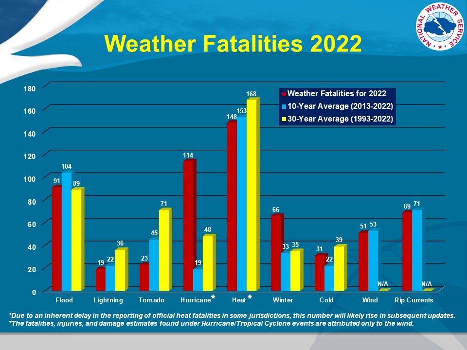
-
July has arrived ... the Meteorologically defined mid summer month
Typhoon Tip replied to Typhoon Tip's topic in New England
That NAM solution came in quite hot. Not sure the populous is really used to what 92/74 feels like -
People must have access to MJO models that are not found thru CPC’s web resource because there’s not much suggestion there at this time.
-
July has arrived ... the Meteorologically defined mid summer month
Typhoon Tip replied to Typhoon Tip's topic in New England
It's interesting because this isn't really a 'BB' circulation manifold but where ever the 4th of July was not ruined deliberately by metaphysical/super natural powers ... that is the affect, nonetheless


