Typhoon Tip
-
Posts
44,236 -
Joined
-
Last visited
Content Type
Profiles
Blogs
Forums
American Weather
Media Demo
Store
Gallery
Everything posted by Typhoon Tip
-
-
July has arrived ... the Meteorologically defined mid summer month
Typhoon Tip replied to Typhoon Tip's topic in New England
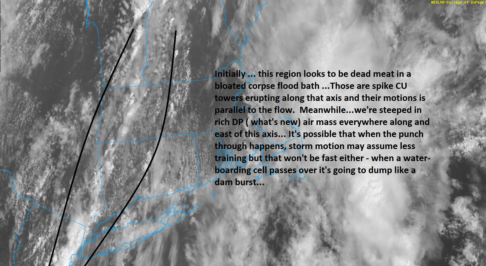
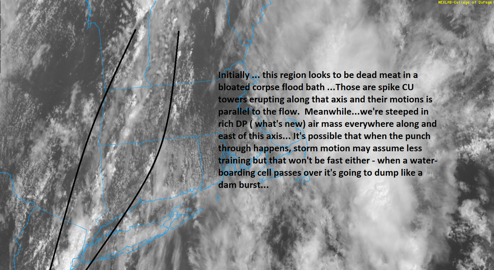
It's been consistently that way. It seems to be eager to quasi close off the surface pressure pattern ... like an echo of a coastal low - albeit weak. One run of this model even had that with fair skies - seems to suggest how it handles hydrostatics more so than from processing. -
July has arrived ... the Meteorologically defined mid summer month
Typhoon Tip replied to Typhoon Tip's topic in New England
... all healed up an released in time to be buck shot by a hunter this autumn -
Looks like that missed the early July passage
-
July has arrived ... the Meteorologically defined mid summer month
Typhoon Tip replied to Typhoon Tip's topic in New England
The NAM has been much more sensitive with surface synoptics on that day... It keeps folding the sfc pp around such that the coastal plain from Maine to NYC is basically in a quasi bd air mass - but it's really like it's a "dry coastal low" - even in the sky. I mean it may be partly sunny at ORH at 18z on some of these NAM versions, with a NE breeze holding Ts to the upper 60s to mid 70s ( low els). The GFS has less of that, and allows more of a static or COL low level/variable flow with probably more humidity. Thus more instability. Not sure... the NAM has superior resolution. But, the NAM also has a propensity to be overzealous with anything resembling cyclostrophic circulation manifolds in the general axis from Richmond VA to NS... I've talked about this in the past - when it has one of those savory snowy coastal inundation in the 72 hour range, and is farthest NW of most guidance, as a typical winter bias. This smacks as some weird vague sort of echo of that bias happening in this troughy summer pattern. -
July has arrived ... the Meteorologically defined mid summer month
Typhoon Tip replied to Typhoon Tip's topic in New England
Sort of ( here) ... it's like we shaved 5 to 7 F off the DP but we were so overwhelmingly anomalous the last 3 days or whatever, being 66 DP seems a lot cooler. That and the temperatures are also hanging around in the 70s this hour. We need a WNW wind d-sloping 55 DP air with +15C 850s, to send the T up to 86 under an unimpeded sun. -
July has arrived ... the Meteorologically defined mid summer month
Typhoon Tip replied to Typhoon Tip's topic in New England
that was probably exaggerated by an anomalously wet summer/soil moisture issue. Interesting... yeah, that would make the severe criteria for wind perhaps lower than normal before that kind of impact begins to occur. -
July has arrived ... the Meteorologically defined mid summer month
Typhoon Tip replied to Typhoon Tip's topic in New England
No … because apparently it’s going to be 82/58 in clouds of these needling mosquitos so dense they’re going to have to extend the air quality alerts -
July has arrived ... the Meteorologically defined mid summer month
Typhoon Tip replied to Typhoon Tip's topic in New England
It's called either a strong coastal storm, or the rarer yet .. a TC -
July has arrived ... the Meteorologically defined mid summer month
Typhoon Tip replied to Typhoon Tip's topic in New England
Interesting... now that I look a the GFS' 850 mb synoptics over the 06z run it's corrected pretty significantly hotter during that time range. -
July has arrived ... the Meteorologically defined mid summer month
Typhoon Tip replied to Typhoon Tip's topic in New England
Finally ... a hot Euro solution in the east. Not sure I trust it, but D8-10 would be near 90 eventually to 96 through the period. So being that it's D8+ it's obviously not very dependable. It's there nonetheless and I don't recall +20C+ SW heat release air ever being modeled to expand into across the mid lat continent, yet this summer. The GFS won't give up on the trough in that range, so no go. Instead sending new cold fronts ... It has persistence on its side. -
Occasional Thoughts on Climate Change
Typhoon Tip replied to donsutherland1's topic in Climate Change
Humans are too much so constrained only by what they can directly observe. “…the biggest problem with humanity's acceptance ( though that's changing, finally - still not fast enough) was always the abstracted nature of climate change. It simply doesn't directly appeal to the physical senses. If you tell a person to move off the train track because you happen to know a train is coming around the bend very soon, the person doesn't react to move off the track. No. They first hesitate to observe the approaching locomotive - then, they might move depending upon the result of confirmation. However, obviously if they are warned to move off the track while the train is clearly visible and is audibly unmistakable, they don't wait to gather in their senses in the matter they move f- off with certain haste. Humanity is like that with climate change. We're in this ominous period of looking around and listening, trying observe a phenomenon that only until quite recently ... was utterly unknowable beyond climate statisticians and advanced predictive modeling ..etc. -
July has arrived ... the Meteorologically defined mid summer month
Typhoon Tip replied to Typhoon Tip's topic in New England
know what would be cool to see ? Take a slab of that air mass from sfc-700mb level by 10 miles in every direction, and plunk it down naked in the middle of the Antarctic continent. Coke and popcorn show, huh - -
July has arrived ... the Meteorologically defined mid summer month
Typhoon Tip replied to Typhoon Tip's topic in New England
https://www.cnn.com/world/live-news/global-heat-wave-weather-temperatures-07-18-23/index.html I was tongue-in-cheek over this in the climate forum ... um, who decided 160 is 'considered the upper limit' ? I don't doubt there is an upper limit but 160 is used to slow smoke-roast a full bird turkey. Jeesh. -
here too in all honesty .. but in the shadow of 'what could have been' it was annoying -
-
I'm really curious to know how this theoretical 160 deg F has been determined ... CNN - "Southern Iran registered a heat index value — the apparent “feels like” temperature to the human body — of 152 degrees Fahrenheit on Sunday. Heat indexes of 160 are widely considered the upper threshold of what humans can endure." https://www.cnn.com/world/live-news/global-heat-wave-weather-temperatures-07-18-23/index.html Because you can slow smoke-roast at full bird turkey at 160 F ...
-
Folks may not remember but we spent a couple few days when that was some 7 days out, where the runs were plotting 970 mb lows on the Del Marva ... It really only committed to a Cleveland Super Bomb redux track until like 84 to 96 hours out... Then, as the arctic intrusion across mid latitude continent made a lot of press (that probably doesn't get remembered to well in the shadow of the enormous LE blizzard over NW PA/W NY) by the time the low pulled N into Ontario and the cold did the old under belly route, it was sort of modifying already. The cold we got was not very impressive. The cold with that weird 20 hour deal in the first week of Feb was probably the only headline we earned that entire wretched season. I cannot confirm or deny ENSO was the culprit last year ... and given the context at hand, I'm inclined to say it was only partial... etc. Just the same, I am more than happy to have finalized the divorce proceedings with that particular three years of history -
-
sorry, that first sentence made me laugh - it's like 'yeeeah, all that, and, it sucked anyway' I know that's not what you went on to describe in that. You know, Will, even before the ENSO questioning became so, I can remember arguing in the early days of Eastern ..some Jesus 18 years ago ?? are you f'n kidding me. I remember arguing that the polarward indices were as important for the NP-GL-NE regions of the continent. Some seasonal outlook of yesteryear, NCEP finally said, "it should be noted that the northern plains, great lakes and new england regions are prone to intraseasonal time scale variations of the polar field indices which cannot be determined at seasonal time leads," it was an hallelujah moment ... I don't really admittedly get into seasonal outlook. I suck at it. Because employing the above facets, one can be completely sound in their rational, and then something WILL happen seemingly by creepy design LOL.
-
Doesn't matter to me who is/was or what, it only matters going forward - I just want folks to stop engineering these seasonal forecasts based on ENSO "in a vacuum" as you so eloquently stated. But it doesn't even have to be in a vacuum, per se. I mean you know this ...but it's all weighted - in other words, how much of, can be reliant from ENSO versus - that's where the real art is going to be drawn. The new norm in seasonal forecast approach cannot be so reliant. etc etc
-
July has arrived ... the Meteorologically defined mid summer month
Typhoon Tip replied to Typhoon Tip's topic in New England
Plus ...spc's upgrade to slight for severe - just sayn' -
July has arrived ... the Meteorologically defined mid summer month
Typhoon Tip replied to Typhoon Tip's topic in New England
-
Lol. I’ve been saying it for about 15 years… But yeah I’m sure others have too.
-
July has arrived ... the Meteorologically defined mid summer month
Typhoon Tip replied to Typhoon Tip's topic in New England
Mosquito population explosion over the last week. -
Cyclical or Natural Predictable Climate Change Forum
Typhoon Tip replied to ChescoWx's topic in Climate Change
Jesus Christ “AGW” is a planetary integral. UHI’s are negligible in comparative scale yeah … big cities are why there’s marine heat waves threatening to collapse the oceanic biome, why there are methane hydrate blowouts erupting through Siberian permafrost… ,state sized ice sheet calving events and measured oceanic circulation velocity shortening because of flux disruption in the thermal haline mass distribution. This may be more directed to the straw man but I grow tired of reading or hearing this from people - like the ethical scientific ambit doesn’t know the difference and must be conflating UHI effect with the whole world - got it. By the way, UHI has increased right along with CC. Just like heat waves have also increased in duration and zenith … If anything AGW is causing UHIs to grow hotter … not the other way around -
July has arrived ... the Meteorologically defined mid summer month
Typhoon Tip replied to Typhoon Tip's topic in New England
Yeah right. Let’s get a PRE up here to really put this summer out of reach