

Typhoon Tip
-
Posts
44,243 -
Joined
-
Last visited
Content Type
Profiles
Blogs
Forums
American Weather
Media Demo
Store
Gallery
Everything posted by Typhoon Tip
-
Wake Me Up When September Ends..Obs/Diso
Typhoon Tip replied to 40/70 Benchmark's topic in New England
Looks like we had circulation recapture take place with O -
This is great news ... I was hoping to see this content, "...are increasingly incorporating longer-term trends that do not reflect interannual ENSO variability. In order to remove this warming trend, CPC is adopting a new strategy to update the base period.... ...the ONI values over the most recent decade will change slightly because of the inclusion of more recent data." I mean I assumed they weren't idiots. Lol. yeah, cool
-
Wake Me Up When September Ends..Obs/Diso
Typhoon Tip replied to 40/70 Benchmark's topic in New England
There's an unusual amount of blight/Septoria that's in the canopy of a lot of species, not just Maples... My lilacs wilted brown and downed by early August. Now, they are budding again and even put out a feeble bouquet or two. Never saw an autumn bloom from this species lilac - some do but not this one. It almost reminds me of the 2nd green up in 2011 November post the Octo snow. It's as though the organism is trying to eke out a growth cycle before the sun's really gone I was reading that there is an unusual plague of it because of historically high DPs this summer. So, a lot of trees are going straight to brown. It's probably still present. Even our "dry" days up until just this recency have been like 64 dps. -
Wake Me Up When September Ends..Obs/Diso
Typhoon Tip replied to 40/70 Benchmark's topic in New England
It was also about 8 mb too weak with initialization of O this morning... My thinking is that a stronger 0 will consolidate the moisture ... well, basically just change the synoptic landscape. The idea of ejecting the isentrop lift plume really is/was a residual warm front but the identity of that is in question when it is attached to a developing TC. The other models are weaker with that lead stuff and they are also deeper with the O -
I have a question regarding how NOAA determines it's anomalies wrt these SSTs. Are these based on historical, empirical data averages alone? This is different than RONI. I'm asking because it occurs to me that this El Nino should have the CC -attribution negated from it.. I think RONI covers a bigger manifold of relative metrics? I'm just wondering if the warmer canvased SSTs then situating 1 C of real El Nino, might look like 1.5 but really just be the 1
-
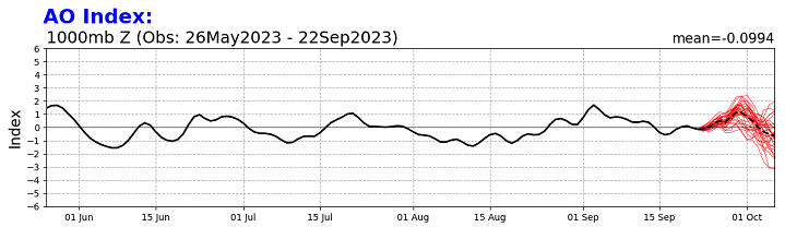
I'm sure you're likely versed in this but for the general audience ... This positive AO projection from the GEFs-based CPC source is a relatively new telecon modality. If it has legs, you want that at this time of year - if your rooting on recovery rate of sea ice Also ... land-based cryospheric concerns while we are at it. Like I've said in the past, the rate of recovery along the Siberian to Canadian archipelago sector, wrt to autumn land-snow/cryosphere appears to be a better correlation to N/A American Dec temperature. Now, ...that's just one in many correlations in the pallet. So that is just a coarser sort of perspective. But positive Arctic Oscillations, while being a warm signal for the mid latitudes beneath the 60.. .70th parallels, is actually a cold and stormy one above amidst the arctic domain itself. This is a new modality ... it may strengthen, or it may not have legs and settle back. Frankly, as we tip deeper into the cold, ... the correlation between AO and warm ENSOs begins to favor the negative AO. But for now that's not yet significant. If the positive AO strengthens some it might be interesting to see if there is a gain/acceleration, however small or large notwithstanding, that temporarily exceeds the normal seasonal growth that occurs post the sea ice nadir, wrt to sea ice. And while we are at it, do we observe land snow pack advance in those polar regions.
-
Wake Me Up When September Ends..Obs/Diso
Typhoon Tip replied to 40/70 Benchmark's topic in New England
Well ...yeah, but don't take that as gospel. "Leaning toward," has some wiggle room. As model evaluators vs that existential aspect, it's a bit of an 'art' because experience doesn't dictate the future. Then on the model side, we have to understand that the models do not actually "predict" the future. I know that sounds a bit weird considering that they are projecting scenarios outward in time. That certainly looks like a prediction about the future. But what they are failing/can't really do, is predict the "emergent" properties of motion and momentum in time. They only use physics to predict what those would be IF there were no emergence of new forces along the way. If the future did not have interacting forces causing new permutations, the models would probably be exceptionally correct out to exotically long leads. But, as nearly an infinite number of counter-actions arise, some are positively interfering (re-enforcing), while others are negatively interfering (terminating) with one another. This is very similar to "fractals" in chaos mechanics. Some fractals self-terminate, others go on to dictate a pattern modulation... As far as the ensemble individual members, they are using slightly different physics in each member. So, those are referred to as 'perturbed' ... The physics they employ have some experimental bases for being valid, so they are allowed to offer scenarios that could take place in a plausible manifold of outcomes. But usually, the ensemble mean will (thus) perform better than any individual member. The operational (deterministic) solutions use the those physics that are best performed. -
Wake Me Up When September Ends..Obs/Diso
Typhoon Tip replied to 40/70 Benchmark's topic in New England
at some point you just have to move on haha. cuz despite the cleanliness of our efforts, we'll go through this exact same game next Sept/Oct, with the same people posting those red(blue) colors apparently basing a NARCAN(dopamine) dose upon them. -
Wake Me Up When September Ends..Obs/Diso
Typhoon Tip replied to 40/70 Benchmark's topic in New England
I'm staring to lean more blocking, myself. I think there is some synoptic oomph for imposing isentropic lift over the region on Saturday. But even it would seem more intense SW, vs NE zones of SNE. By Sunday morning... I could see this trend in the models to "split" the overrunning momentum E, while the residual Ophelia is held back closer to bombing eastern PA/NJ with a flood threat. Obviously we've all been onto this weekend's synoptic shenanigans, no need to readdress. But I just think along years of experience with these evolving deformation axis, roughly ALB to BOS ...and they usually end up correcting the moisture to a pretty sharp gradient as far as what ends up in buckets. -
Wake Me Up When September Ends..Obs/Diso
Typhoon Tip replied to 40/70 Benchmark's topic in New England
Plus ( for the 187th time ...) ... those categories don't 'ruin' winter - so to speak. They don't quantitatively define the extent of any anomaly. They literally just mean, there is an above normal chance for above normal. Nothing else. This point is either tactically evaded ... or, not understood despite the explained 187 (est lol ) remedial course work. Even a Down's student would get it by now for f'sake I mean seriously, can this point get across once and for all ? If the winter averaged .01 F above normal, ...guess what? that product NAILED it! But .01 above normal with an actually coupled warm ENSO hemisphere would bury everyone alive N of Jersey. Now... it is just unfortunate enough that 'above normal' could also mean the warmest winter in history. Sure. But for now the 188th time ( est ) ...that product does not ruin winter. It only says 'chances of above normal' and nothing else. It should not be used as NARCAN ...nor divisively by those that want to yank short brown ones - either way. -
Wake Me Up When September Ends..Obs/Diso
Typhoon Tip replied to 40/70 Benchmark's topic in New England
2nd in unredeeming only to April -
Wake Me Up When September Ends..Obs/Diso
Typhoon Tip replied to 40/70 Benchmark's topic in New England
That models are there to offer plausible scenarios. It's up to the operational Meteorologists (forecasters) to determine the likeliness of any given solution, or the consensus thereof. In the early days of modeling, there was much more bandwidth for "reasonable doubt" Forecasting relied upon more of a combination of the model solutions together with experience and/or particular insights of the forecaster. However, in more recent/modern eras, modeling has improved enough that the forecaster doesn't need to be as much of an 'artist' in shorter lead times - in fact... sometimes now, particularly for < D4(ish), more and more forecasters still attempt to out fox or think the models, and end up eating it for having doubted. The speculation game ( using education, experience and intuition) in forecasting has shifted more toward ~ D3, increasing days 4 or 5, and almost completely necessary beyond D7s. -
Wake Me Up When September Ends..Obs/Diso
Typhoon Tip replied to 40/70 Benchmark's topic in New England
posted some thoughts in the tropical thread re the region east of Florida and implications up the coast. -
So NHC has declared the region some 200 miles E of central Florida as 'Potential Tropical Cyclone 16" I mentioned that region several days ago but the question remained whether whatever comes of it would be purely tropical or some venture along the spectrum to a hybrid type genesis...etc. Still out there. But, judging by the high res imagery and so forth, that looks as though it'd couple to the sea surface pretty readily - so I'm leaning tropical more so now... Having said that/if so, it would change the picture a little up along the upper MA /SNE regions for this weekend. I suspect what the global models are doing is peeling off a bit of warm IB and leaving behind what they "think" is hybrid phased weakening cyclone somewhere along or inland between the Del Marva and NYC to then meander thereafter through early next week. However, *IF* a singular and [probably] more intense/intensifying actual TC occurs, that probably invalidates a lot of that mean synopsis. You could end up with anything from a "Bob", to west impactor, to a curve away with no impact... something else other than these erstwhile solutions.
-
https://phys.org/news/2023-09-riddle-varying-inflow-arctic.html
-
Wake Me Up When September Ends..Obs/Diso
Typhoon Tip replied to 40/70 Benchmark's topic in New England
I noticed that this morning too, kinda like a 'seasonal step down' . Problem is... the deep layer pattern is sort of non-committal. Cross that bridge ... I've noticed more and more so the 'over top high pressure' scenarios in the runs, tho. -
Wake Me Up When September Ends..Obs/Diso
Typhoon Tip replied to 40/70 Benchmark's topic in New England
ha... if we want to get down to it, drizzle f's up just about any outdooring -
Wake Me Up When September Ends..Obs/Diso
Typhoon Tip replied to 40/70 Benchmark's topic in New England
uh oh -
Wake Me Up When September Ends..Obs/Diso
Typhoon Tip replied to 40/70 Benchmark's topic in New England
below the sniff line -
Wake Me Up When September Ends..Obs/Diso
Typhoon Tip replied to 40/70 Benchmark's topic in New England
yeah, hoping for the NAMian penchants for being too far NW -
Wake Me Up When September Ends..Obs/Diso
Typhoon Tip replied to 40/70 Benchmark's topic in New England
Dangerous flood situation ... one whose total circumstance began to materialize way back in June. -
Completely out of left field ... I was just talking to a neighbor about autumn's onset and when the colors will arrive. The oldest tree on the block is this small-leaf sugar maple that's like nearly 100 foot with nice symmetric canopy, having a diameter some 70 feet. Huge. It's just ever so slightly tinge-ing on the top edges. Despite that size... a tree guy ( on the property for another issue ) was saying a while ago, 'despite that size ... most trees in the area that are that big are actually not more than 80 or 90 years old - because of ... 1938.' Heh, I always thought that big sucker had to be one of those 250 year old guys. Anyway, when I mentioned 1938, she said "...Took the roof of my house." Guess she inherited it from her grandparents. 'Took the roof off' Hmm so Ayer Massachusetts is something like a 100 miles N of the south shore of SNE, in the heart of the Nashoba Valley, no less. I think the elevation at town hall is all of 220' above sea level. That's pretty cool to think that the wind was capable of peelin' roofs this far away from a landfall some 100 miles a-yonder. An homage [probably] to how fast while most importantly ...still powerful it was when it careened onshore LI, yet still possessing enough power to saw trees in half and impart building/structural major impacts up this way. To me it really underscores the assumption of safety fallacy around here ... Because the "structure" of civility, codependency on multiple facets, is quite apples to oranges comparing 1938 to modernity. It's almost like less development back then, makes the magnitude incomparable - there's vastly more to lose, now. 'Magine a 1938 redux + some amount of CC-attribution quotient ?
-
Wake Me Up When September Ends..Obs/Diso
Typhoon Tip replied to 40/70 Benchmark's topic in New England
Yet we can’t find a river in flood. -
Has any seasonal outlook ever ‘cast the winter as much below normal snow fall with temps above normal? seems not but who knows. You wonder if no one has ever gotten that right … yet it characterizes more winters than half in the last 30 years. Lol
-
https://phys.org/news/2023-09-china-global-merged-surface-temperature.html


