Typhoon Tip
-
Posts
44,241 -
Joined
-
Last visited
Content Type
Profiles
Blogs
Forums
American Weather
Media Demo
Store
Gallery
Everything posted by Typhoon Tip
-
seems there's always 'big winters' coming from some source or even aggregate cluster of them. I figure it for being colder than summer at this point... There are competing signals in my mind - seein' as anyone et al gives a rats ass. 1 ) early and late season blocking becoming more prevalent - related to CC forcing circulation modes - are independent of ENSO this, PDO that ..., since 2000. This tends to promote early cool snaps that are sufficiently cold to be 'winter like' if not supportive of cryo hemisphere. But they are transient extremes ...tending to waver back warmer than normal. Basically, the late Oct - mid Dec may succumb to this aspect, and thus ... only seemingly well correlated to ENSO - driving the faux attribution. At other times, not well correlated looking. 2 ) ENSO warm tends to be wet and warm early, and cold and snowy late? check that... I thought's what it was. But the points of number 1 may interfere with that on either ends. 3 ) the mid winter circulation mode of the hemisphere may become velocity saturated with approximately 6 to 10 dm more height gradient between the 60th and 35th .. basically along the seam of the HC and Ferrel latitudes. This has also been a recurrent theme in winters over the past 20 years, regardless of leading indicators. When that happens... it forces the R-waves into configurations that don't match the historical inference for pattern forcing back whence. These modem winters have greater variation and temperature extreme between N and S latitudes.
-
Yeeah... < than 5 days is open to dialogue/skepticism. I mean it's no longer futile to engage in that analysis. You know I had coined the phrase 'predictive event horizon' - meaning that position and intensity forecasts beyond that point in time/extrapolations were so open to variability as to be essentially no skill. We've gone across that. We can begin to shed some solutions which narrows the goal posts
-
'Statistical interpretation' is a kind of interpretive art, too. I mean, from a much larger perspective ... does Lee count in our 'return rate' ? Unless we want to bake the concept of being exact to region in our return spatial domain - but that's less realistic. Is nature too messy for that? What I mean is, it's like wiser to suspect that if one were to observe ... say 5 TC's over 50 years, that were above the 90th percentile of having dodged all the reasons not to come here, those that struck were all part of those 5 - not all 5 did. In the end, I wonder about the futility of the return rate stuff, at all. I mean, you could get 1938 to happen twice in 10 years, than not see it for 780 years, then have it happen 8 times in a some future two -decade span, one might be inclined to think that means every 108 years. mmm It really means that every once in a time span, there is a flurry of them. Moreover, the setting/cause for the flurries seem to be random distribution.
-
At this point I'd be seriously happy with that - anything to scour out this scunge stasis of atmosphere.
-
Wake Me Up When September Ends..Obs/Diso
Typhoon Tip replied to 40/70 Benchmark's topic in New England
What might take a bit of 'philosophical thinking' to get this idea across, will definitely trigger deniers to scoff ... but the Lybia catastrophe may be entirely human caused. Some may read that premise statement and immediately go to civil engineering planning and pull many ideas from under that heading and so forth. And they may not be wrong. But this exceeds that in larger orbital perspective. First, humanity's modernizing technology and industrial era driven ability to ever increase the manifold of conquering-over-nature potential shows up to unleash it's power over the surrounding natural order, by constructing huge dams in what really is for all intents and reasoning, a dessert environment. Whereby supporting a civility that would inevitably become large for benefiting from that same anthropomorphic modulation model, that required areal expanse. It requires lots of infrastructure of all kinds to support, built over a big exposing region - a region that is dessert should not require a concern for flood erosion? That's absurd. But, all the while ... that same anthropomorphic model has been taking place all over the world for the past 200 to 250 years ( since the ~ IR (industrial revolution) ) ... slowly imposing an unintended change along the way. Among the ambrosia of ways in which that was merely only unable to be seen; climate change was only seductively silent. The history we bought a ticket upon has deposited humanity upon the island of Liliput, where we are now overcome ( perhaps overwhelmed being apropos ...) with needing time to codify these changes through a scientific process to prove, when we are running out of time. Meanwhile, the Liliputians of consequence rise in multitudes in every facet of nature we look. It's an interesting metaphor - Here's the thing. This is two seemingly and utterly different human promoted vectors through history: Lybia's rise from the sands of time, coming to a nexus with a marked increase in the observation of these so-called "medicane" phenomenon - just one of the fast becoming untenable ingredients in the ambrosia... And we can be sure medicane increase in frequency is still being sent through the attribution math, no doubt. This really creates an allusion to two, human made vectors, set into motion hundreds of years ago, that would come to an inevitable collision along some future date. We gone and create a civilization mecca that is vulnerable to a type of phenomenon so utterly (originally...) unlikely in that setting of the planetary system, and then drove the climate to impose that unlikeliness. -
Wake Me Up When September Ends..Obs/Diso
Typhoon Tip replied to 40/70 Benchmark's topic in New England
... with enough seasonal lag to supply Venus with its thermal budget. -
Wake Me Up When September Ends..Obs/Diso
Typhoon Tip replied to 40/70 Benchmark's topic in New England
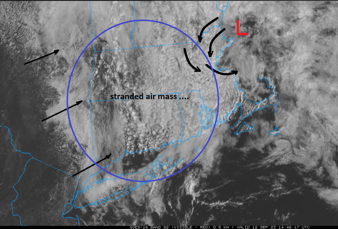
There's an attempt to move PA/NY air over New England ( left arrows) but it is too weak. Looping this image above ...this area E of the elevations is 'trapped' and although still around 70 with DPs, is still having trouble eroding away below ~1,800 or so feet. Weak meso-low also NE of Cape Ann has imposed some circulation/BD effect into NE zones, too. All and all... an anatomy of a gloomy piece of shit morning.
-
It's actually more interesting that the climate based and official (NHC) aren't terribly better, either. That's possibly telling as to this one's 'historic-based irrelevancy' ... nice way of suggesting 'bias' in general.
-
Ha ha ... lol, just got done wondering if the HAFS-A and B were better solutions for the time being.
-
I almost wanna do a surf chase ... I haven't done that in years. Not really there for the storm itself, but just to ogle coastal impact.
-
I kind of like these recent runs by these HAFS-A and "B Aligning track that's a compromise, they bend back but also ...weakening dramatically - as they should - for passing N of the G-string out there and spending some 250 naut miles over mid 60s SSTs. They still bring a 975-ish low somewhere N or NE off the outer arm of the Cape, but filling pretty quickly, the wind field is probably not really being experienced very much more than 5 miles inland - and considering the stable land air source being pulled in, it's lifting a lot of that edge moment off the deck at the beaches themselves. something like that... This thing's bigger more obvious discussion headline really should be about the 20 ft curling bombs with white foam momentum running up and over shore roads. Maybe even foisting a boulder or two up onto the street. (taking liberty with description here)
-
Mid upper level vortex appears to be rotating at a disproportionately slower speed than the llv. I'm wondering if by some small but perhaps crucial amount, this thing's low to mid level structure is modestly uncoupled.
-
Don't disagree in general. The 'stress' of (shear+ EWR)/2 results in functional citizen that still has PTSD triggers. LOL. Anyway ... I have almost never seen a hurricane achieve the same wind max post a EWR, regardless of particular case stresses. They are almost always slightly to more obviously not as deep in the pressure well, while also slightly to more obviously weaker with wind fields. But here is the interesting thing - they are not "weaker" cyclones. By spreading their cyclostrophic energy over a broader area, post EWR, they actually have the same or even greater ISE. There's a physical reason for that, which can be explained in relatively simple terminology. The EWR is a way to spread the gradient out in all directions. If a hurricane reaches a deep well in the atmosphere at a small to mid-sized t-cyclone, this can become too intensely unbalanced against the ambient atmospheric pressure surrounding the storm. The centrifugal force that 'opens up the eye' is overwhelmed. But the ongoing storm's momentum/mechanics are conserved ... so a resolution to this problem is the EWR. By widening the eye, no longer exceeds some critical ratio of surrounding pressure medium with respect to the core - and the circulation stabilizes at a larger size - lower wind velocity, around a larger circumference achieves the same ISE ( or even more) but is 'balanced' against the surrounding storm medium. So it is a bit technical ... but I tried to tone it down. So, ...this is where your shear showed up. It sort of intervened at that critical vulnerable time. The storm got larger, but the core disruption can't find the post EWR stable attributes because it's partially uncoupled within the total circulation manifold - this part is a bit more suppositional. Doesn't mean Lee won't 'reconnect' and fall back in love... ( 115 is a better relationship than I've ever found!) But it's moving slow. I wonder what the thermocline is in that region and if it can whirl around at 110 mph forever without it up chucking colder water and choking in its own vomit.
-
06z Euro looked to have bumped E a little
-
The issue with the Euro isn't really hugely bad model performance - or that which is perceived to be before the fact, ha. It is that we are hyper focused on very small variance in position, because that actually matters (this is a philosophy/reality post). A 200 mi shift E vs W is the difference between partly sunny with a gust to 25 or 30 mph from the N along the beaches, ...upwelling cold water and ending the swimming season, vs lashing the eastern zones with sustained 38 and gusts perhaps to storm force, and possibly also becoming a primed flood risk as far back west as ORH-CON. However, this is still D4.5 ... so, 200 mi of error at D5 is actually 'better' than the performance target by NHC themselves. So, calling out the Euro as a big piece of useless shit and saying 'what's happened to the fallen' angel and whatever is an over-application of fault finding due to the former. People want two aspects: accuracy now (that can't really be assured), and elation at the possibility as it is illustrated in the model runs. They are very good at sniffing out 'false illustrations,' but that is no different than a NARCAN rescue arguing with the life saver for ruining their high. So they trash the model ... There should be real evaluation that isn't too excoriating at this range - not yet. If the Euro persists with this solution and shorter than 72 hours, and then fails... then it becomes a matter for more rational analysis as to what went wrong.
-
Heh... right. But my previous was really an attempt at 'seasonal symbolism' ... The point of 1938 antecedence is like that year was Russian sort of roulette. They clicked the trigger one too many times. Maybe we're doing something similar this year. I recall we've discussed at a couple points along the way, this propensity to reload the +PNAP ( not necessarily the same as the "PNA"). At a very foundation level ... that tendency is perhaps a precursor. I was just looking at a chart someone has posted in the Climate Change forum that described the summer temperature departures and no surprising, This nicely reflects expectation for/when having a +PNAP reloading summer. Like, gee - where's the trough, Waldo. Meanwhile, the modest warmth along the East Coast and New England is more indicative of ... well, what we are observing right now: we are on the E side of that circulation mode and we are stuck in a 'sultry wet summer'.
-
Wake Me Up When September Ends..Obs/Diso
Typhoon Tip replied to 40/70 Benchmark's topic in New England
Oh I know. I wonder what the return rate is on a dessert coastal country getting 20” of rain -
Wake Me Up When September Ends..Obs/Diso
Typhoon Tip replied to 40/70 Benchmark's topic in New England
‘Catastrophic’ flooding hits Libya as dam collapse washes neighborhoods into sea, say officials … thousands feared dead… Attribution science’ll have a field day out of that one … tho admittedly, Libya being a desert region does send a moment of pause -
Wake Me Up When September Ends..Obs/Diso
Typhoon Tip replied to 40/70 Benchmark's topic in New England
I hope in the winter we get a shield of exotic inches/hr snow that just crawls it’s way -
I seem to recall reading once years ago how the 2 weeks before 1938 was described as ‘unusually wet and sultry’ Now granted, sultry is rarher outmoded as a word usage in present culture … But I believe having so many persistent dewpoint days over 70° with daily run-ins with flood warnings and stuff qualifies as similar to that same turn the phrase
-
Wake Me Up When September Ends..Obs/Diso
Typhoon Tip replied to 40/70 Benchmark's topic in New England
I’ve never seen so many days with DPs 70+ in September -
Wake Me Up When September Ends..Obs/Diso
Typhoon Tip replied to 40/70 Benchmark's topic in New England
CC -
Until the 18z got that memo …
-
I was kinda hoping we'd stall an arc of 48 dbz tropical mode rain right through a region with +300% of the seasonal budget already in the Earth ... just sort of have it sitting there blithely twitching away for hours and hours...
-
I was just wondering what the rain totals there would be After the summer we've had ... ? dumpster boats