

Typhoon Tip
-
Posts
44,240 -
Joined
-
Last visited
Content Type
Profiles
Blogs
Forums
American Weather
Media Demo
Store
Gallery
Everything posted by Typhoon Tip
-
that evolution looks unlikely ... just sayn' -
-
Occasional Thoughts on Climate Change
Typhoon Tip replied to donsutherland1's topic in Climate Change
https://phys.org/news/2023-09-life-threatening-events-world.html "The model showed more places experiencing heat events that would not be considered survivable under the wet bulb test as the planet grows warmer. A global increase of 2°C, for example, would result in 25% more places experiencing such events. Those increases, the model showed, would sometimes be in places not accustomed to such heat, such as parts of the East Coast and Midwest in the U.S., and in central Europe. " -
Getting close to that time of the tropical season where I start hearing that voice in my head begging to just get past this p.o.s. journey and make it winter already. LOL
-
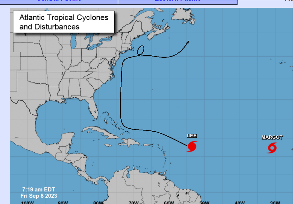
Ho man... 'cane enthusiasts can't win. The next one by the GFS looks to get even more agonizingly close yet still missing -
-
mm. I know what your getting at but there's probably dubious morality there, too -
-
I posted about this subject matter in the tropical thread ... but, if this transitions the western semi-circle winds will lift off the deck and it won't be very memorable.
-
Regardless of any wind/rain aspects ... the primary draw in terms of this thing's entertainment value may be the surf/beach erosion.
-
Occasional Thoughts on Climate Change
Typhoon Tip replied to donsutherland1's topic in Climate Change
Ha... it may be entirely serious and credible ... haven't looked. But just the turn of phrase, 'block out the sun,' when in deference to 'not meeting climate goals' sounds like a Wiley Coyote solution - -
I mean... whence the transition happens, or we are just flat out dealing with a nor'easter ...there are a couple aspect immediately/physically taking place that limit wind - particularly on the western-NW arc. The air is stablizing in that sector, with cold entrainment cutting under the TC's circumvallet. That lifts the wind field off the deck ... hasta la vista style. The barotropic model remains well ( better..) mixed with plenty of 'momentum transfer' and well ... TC are a lower tropospheric coupled model solution - particularly preferential to the warm ocean; that is in fact considered a quasi-coupled machinery. It really it's a miracle of nature on Earth that all that OHC can have a machinery available to directly exhaust that yato yato yato scaled heat storage. Anyway, baroclinic systems are not coupled nearly as proficiently ...though the warm sector itself can certainly do interesting things when the Warm conveyor belt is gradient pinched into a fire hose and a squalline then mixes that down. I've see 60 mph winds along those ribbon echo babes October before.... rare though.
-
It depends on why the wind field is expanding - I sense that folks are forgetting how the barotropic PGF layout realizes wind, compared to extratropical storms or those transition(ing)(ed). I'll go ahead for the sake of diplomacy assume folks are thinking this system transitions quickly to a deep ETL - If the 'expansion' is because this is transition ( quicker ...) into an extratropical low, then the PGF expands farther out from the center, but you also get other jet mechanics going - like CCB like features and so forth associated with thermal gradients. Which you need those if you are going to realize higher wind on the W-NW arc while the cyclone is passing by to the SE of your location. If the system remains barotropically intact as it is moving passed, there will be less wind experienced, relative to the pressure gradient on the isobaric layout, do to the motion of the storm counteracting the inward restoring air flow
-
It was never impossible (fwiw) despite all the heavy handed negativity and hand throwing in general. It’s likely to not happen. But when that seems apparent folks tend not to be very interested in discussing what can still happen to realize x-y-z … If they don’t see it on the actual model looping cinema … leads to no dopamine jolt and the whole thing is damned to hell. Lol
-
Yeah, well I think the take away is that we’ve got some increase in mop-end going on wrt what was before a better consensus for the extended timeframe – which perhaps that should have been expected at some point. The consensus might have been a false herring at D 9 just maybe … We’ve all seen day 7+ agreement fall apart with coastal storms and/or every aspect of meteorology for that matter not just with tropics. What it all means who the hell knows
-
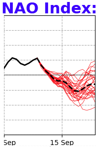
The problem with the Euro run ( for me ) is that it's not impossible that a position may be end up found more West than guidance (as of late) has been depicting all along. ( Not a forecast ...) I discussed this a few days ago, the idea of the 'super synoptic' signal. It's a signal that is not carried ( necessarily ) in the physically materialized model runs, but is carried by the non-linear wave function. That's basically the distribution of probabilities for emergence, based upon forcing that cannot be scene. This is real in wave mechanics, despite sounding quare-root of -i It's also referred to as transitive forcing. The way that works is ... A typically promotes the occurrence of B, which in turn does C ... That's the linear wave function. Non-linearirty occurs when A-->B causes E, but doesn't seem to register an observable forcing on C or D in between. The idea of Lee finding a position left of 70 W and getting caught up in a trough circulation ...even if transient and needing to be timed just so ( making it less likely if not too unnerving for the forum haha), that's what that is. It's when "E" emerges because of what is going on between Japan and Chicago. I'll go ahead and side with lower probability of occurrence ... because there are other techniques just as useful - such as... other models agreeing. Lol. But, that super synoptic signal has been there, and ignored, by the operational runs all along. I've seen these signals not physically materialize. But I have also seen these materialize in short order when everyone gave up. What I am seeing to date is really the NAO handling that's f'ing this all up... This is just not materializing in the operational runs nearly as much as it could (if not should), and if so, ... where is it? east or west limb. When has the NAO ever been handled on a D7+ chart very well. I was and am perfectly content to sit by and downplay this as a low or non risk to the U.S. ... Like I said, sometimes these signals ... -NAO could be east biased. PNA could but E, too... still being +PNA/-NAO, but in whole, the signal means the coastal bombs for NS. Or like last December.. the +PNA massive HA signal was west situated continent, and it ends up over Buffalo. Sometimes you get the bare, sometimes the bear gets you.
-
Seems like guidance et al wants to rush the next one into contention, huh Whence Lee completes its agonizingly obvious ... by then we're already got an impressive TC possibly approaching the 'key-slot' Which by the way, Lee missed that to the NE - just sayn'
-
I'm not under the impression that the greater guidance envelope really saw this coming - the CB pulse routine actually tends to happen when a cane moves over cooler interface waters and is in the process of being cut off from fuel. Obviously ...it's not over marginal SST/OHE, but something ( dry air entrainment ? ) must be interfering.
-
Wake Me Up When September Ends..Obs/Diso
Typhoon Tip replied to 40/70 Benchmark's topic in New England
The eruption that swept out of CT through outer/metro west of Boston during the afternoon, yesterday, produced some of the more frequent lightning I recall in this area for many, many years. There were overlapping flickers, with thunder cacophony that seemed to fuse into a one continuous rumble at times ... minutes in length. Really something. As the storm was winding down, the back hanging anvil was raining positive bombs, too. Some of them were once per 15 sec intervals. These were not the single loud cloud echo away variety - there were several expressions per... It's like the sound created a picture of a lightning bolt that must have been "blinking" for extended time. -
It's been doing that coughing CB's routine this morning
-
This thing looks like it's getting pummeled by shear. Look at all the CB turrets moving from S-> N... and as that's gotten more momentous during the day ...this structural issues have come about. If that's true, not sure that was very well modeled. See? The models are wrong about something .. .lol
-
Nope, never did. I'm impressed for two reasons: ...the consistency from get go - many days. Picking this up at D12 and never deviating - granted, there are more days to come. Wrt tropics no less. The other aspect is a bit more abstract - this is all going on in a hemisphere where the AAM was switching from + to -, also reflected in a mode flips of both the PNA (positive) and NAO, (negative) this next week. That type of relay opens the door for trends to take place in the materialized guidance ... nope.
-
Telecon spread still says it's possible
-
If this goes on to do what the GFS general theme over the last 32 cycles ... has been unable to deviate from showing, this will be a first in modeling history that any guidance was so exactingly correct from 13 days lead ... - or whatever/how-many days it's been. That theme has not deviated enough to consider any other track - not really. Gee, we wonder if it will pull that off when it shows a coastal bomb in the winter.
-
Inside channel/ preview of expected 11 am track guidance ...
-
928 mb 140 kts
-
160 mph
-
It’s comical how that hard right has never changed in the runs now for three days while they move everything else all over the place - thaw shall not pass!


