

Typhoon Tip
-
Posts
43,369 -
Joined
-
Last visited
Content Type
Profiles
Blogs
Forums
American Weather
Media Demo
Store
Gallery
Everything posted by Typhoon Tip
-
It was a Flop... February 2024 Disco. Thread
Typhoon Tip replied to Prismshine Productions's topic in New England
It's an interesting plug into a field that is non -earth sciences related, but is human sociological - ...the irony, to understand the following op-ed requires nuanced open-mindedness. I call it "the great socio-technological experiment" Basics: at no point in human evolutionary past has the advent of technology been so effective at modulating lives at a personal level, than these last 100 ...and in particular, 50 years. And that change in the populate, integrates the populous. Where this goes in terms of cause-and-effect is about as complex a field as Quantum Mechanics - if one understands at a rudimentary level, fraught with "uncertainty" ( lol ). There are pros and cons in how technology "enhances" ... but is is definitely enhancing for better or worse. There's a vast envelope of subtle ways in which that is evidence that ... pretty much given the daily life inside the Industrial bubble ... no one is set up to even consider. That, and the process is so gradual. Until the gross version of that enhancing comes along ... Like, "social acceptable boundaries" are no longer sufficient to stop a gun weilding mad person. Or, besieging new information in a overstimulated population leads to fear --> contraction of belief systems --> nationalistic modes and traditional non/progressive acceptance ... And it is not just a personal scaling -related matter. It's taking place at a species level. There are feed backs like brain dimensional shrinkage. Yeah dude. Capacity in general and lowering I.Q.s. There's papers about this. Adding failure of common intellect, there's less hope that a general bulk populous would stop a village idiot from rising to power ( ) See, the problem is an evolutionary one. At least as far as what evolution means to us. It's creating a "paradoxical dilemma" of sorts. Simply put, evolution leads inexorably to the inability to evolve Simply put, dumbing down. I like that. Conveniences lower the "weight training" of a "species' muscle." Through the arrival applied innovation(s) softening the challenges needed be overcome in order to survive, we unwittingly slow, if not stopss, the Darwinian crucible. It's function was not to provide us with the ability to endow ourselves with the best orgasms of reality we can find - that's just how we are apparently using it. Darwinian motif not only purifies over successive generations of trial and error ( where failures fade and successes breed), but through that challenge emerged newer sophistication and newly arriving aptitude(s). The decline in this latter aspect is symptomatically described by the subtle example of "losing the ability to nuance" Everything in nature ( I've come to find ...) is really analogical to some other aspect. Just like a single electron goes around a proton ... planets go around starts. These are not coincidences. The Universe is the greatest con artist in a way. The idea here is that we are distracted from seeing it; as nature merely cloaks the same model underneath colorful cloths, the pretty patterns actually blind us from seeing the reprisal of perhaps just a handful of original motifs. When we start thinking along these lines ... it really opens up interesting speculations. Like take the fact that 99% of all species that Earth has ever manifested, no longer exist. Perhaps our example here on earth is a reprisal of some yet to be determined fact that say ... 99% of all species the cosmos has ever created also no longer exist. An explanation for the "Fermian Paradox" might fall out of that ( the paradox goes: 'if the cosmos is teaming with intelligent life, or life at all, where is everybody'). Perhaps they've all simply evolved themselves right out their own evolution. Creepy. Aside from the obvious, that does not bode well for any species in existence right now ( lol ), that might just be an analog for what is out there in the cosmos. The universe is nothing more than a great cemetery. One species on Earth ( that we know of empirically ) has ever been capable of asking these questions, much less created technology capable of plumbing the incomprehensible scales of time and space in an attempt to answer the question as to whether we are alone in this thing. Hm? And, if they are passe', what %age of those species were even technologically advanced? But ...here's a thing: ultimately we are dealing with numbers so incomprehensibly large they escape and affective/effective meaning ...so therefore, in any pragmatic sense, were are looking into infinities. And by definition infinite probability insists that some other tech -advancing species like us ( more or less) must concurrently exist. If 1% of the "cosmic life" still survives the "99% gauntlet," that 1% is still an incomprehensibly large number. So this becomes as much a philosophy problem too. -
It was a Flop... February 2024 Disco. Thread
Typhoon Tip replied to Prismshine Productions's topic in New England
HAHAHA ... and here it only took, ... 15 years of engagement? -
It was a Flop... February 2024 Disco. Thread
Typhoon Tip replied to Prismshine Productions's topic in New England
that's how we all know we're reduxing 1978 now .. Thank you for your sacrifice, and congratulations! You are now a member. You cannot be a considered entry into the weather event seeking league of extraordinary hearts, until you've passed that mandatory hazing ritual by god where for some bizarre uncanny parallax of universal events... it is imperative you are away during the precision temporal bounds of the biggest ... whatever happened in the genre coveted as most dear. Just ask Jerry ... he'll explain it to you lol -
It was a Flop... February 2024 Disco. Thread
Typhoon Tip replied to Prismshine Productions's topic in New England
Probably "as is" ..sure. But that "ridge" could end up being less of a full latitude R-wave signature, and more of a blocking node as we get closer - if that happens, we relax the field underneath. That's what happened in the early Feb days of 1978. I saw 06z GFS and remembered other guidance taking turns ( more or less...) and then it dawned on me - wait a sec. Low and behold, it's number 2 on the CPCs list ... umm... not shit. I'm just speculating here. This is not a forecast. I'm also not really trying to up the potency of the d-drip ( LOL ) either. It's just that that we're not making this shit up - CPCs has it there because it is true. Now... granted the analog has that on the 8th, which was after that storied event was already winding down, ... the 'idea' of it is certainly similar genetics. -
Probably take 1/2 to may 2/3rds of that 06z Euro snow product there ... No qualms with 'where' ... but 10::1 seems a stretch in these thermals
-
It was a Flop... February 2024 Disco. Thread
Typhoon Tip replied to Prismshine Productions's topic in New England
If you're a winter storm enthusiast ... you may want to pay attention to how the 31st/3rd period modulates over future runs... Having a recurring theme in the runs ( note the 00z GGEM, too ) of a powerful diving JB jet, while still loading ( altho less, still positive) +PNA tendencies across the continental footprint ... I mean, it's just not dismissible quite yet that something would evolve. That's been occasionally hinted across all of them at one point or another, recently. Euro... Even extrapolating the ICON. This was always a 27th thru the 5th period of interest fwiw. -
It was a Flop... February 2024 Disco. Thread
Typhoon Tip replied to Prismshine Productions's topic in New England
Yeah...I'm behind in this thread ... But, that's all I meant. something like that -
this kinda reminds me of the first of those two Dec 1996
-
It was a Flop... February 2024 Disco. Thread
Typhoon Tip replied to Prismshine Productions's topic in New England
Feels like signal that there’s going to be a very early spring… -
It was a Flop... February 2024 Disco. Thread
Typhoon Tip replied to Prismshine Productions's topic in New England
heh... here's the arriving +PNA, annotated box below I've been noticing that the models are en masse transporting the PNA configuration into that region over the continent. Bizarre ... They start manifesting the +d(PNA) well enough ( basically now...) but before it can mature they dislodge the ridge and transport it to that location and park there. Meanwhile, I don't know wtf to call that Pacific because the ridge around 140 W completely shuts down any polar or southern stream jet(s). It's all weird -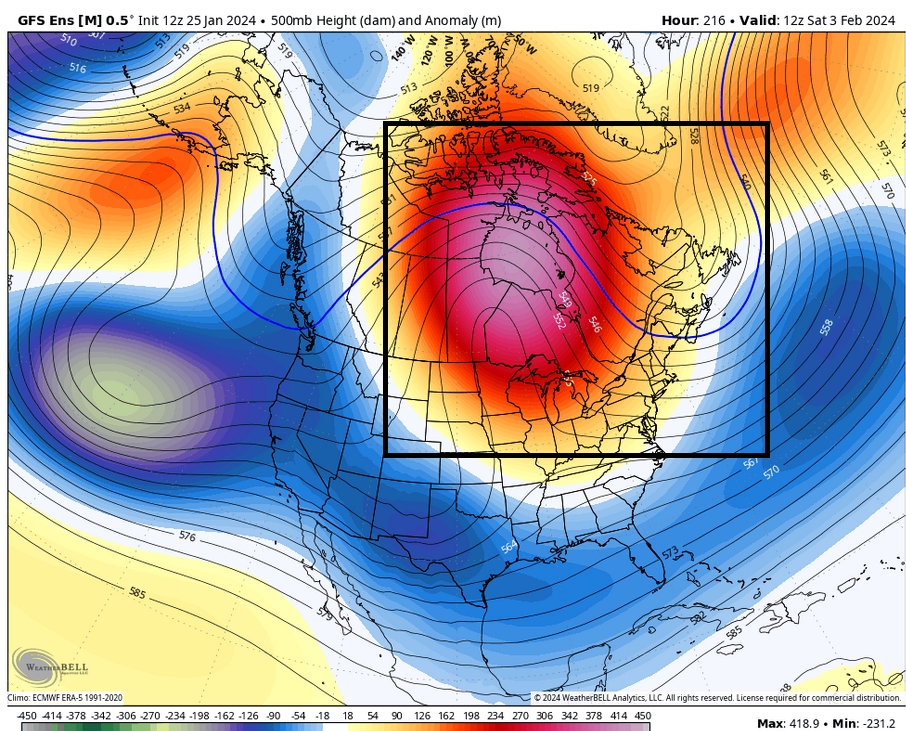
-
I'm not sure some of you made the right read off the Euro - just saw it. It's really not farther S than the 00z run. It's faster along the same latitude - or too close by comparison to make any difference .. not worth the bi-polar reaction ( nervy neurotics for the low haha). This run is in fact slightly deeper than the 00z run - but .. me really enough to matter there either. The only difference here that sticks out to me is the areal expanse of QPF. It's just drier - though it is not abundantly clear to me why that is the case. So be it... That's suspicious. I don't think this run "caved" to jack shit really considering these aspects are so unchanged. The QPF not being as distributed is debatable as even real. This run over all has really bad continuity so ... it's not abundantly clear this run should be used just because its bad and appeals some weird abandonment issues.
-
I love a good conspiracy like the next guy heh... but I mentioned that sentiment a couple years ago myself, but at the time it was an eye-brow raise based upon what I read; they are in the process of a core changes in the way the model is processed - AI/ and even QM hm... It would be more like they're giving us a beta version they know full well isn't as good but is still competitive, as a calculated trajectory. Then they release some kinda quantum computing extra double top secret version which is truly supreme ... for supreme cost. Who's with me! hahaha
-
Heads down at work today but on lunch the GFS looked N of prior run cycle ...which I guess that was 06z
-
It was a Flop... February 2024 Disco. Thread
Typhoon Tip replied to Prismshine Productions's topic in New England
Other way around ... the GFS, in fact ... all global models tend to over amplitude in the mid and extended range, and as the features get nearer upon future cycles, they correct downward. -
It was a Flop... February 2024 Disco. Thread
Typhoon Tip replied to Prismshine Productions's topic in New England
That has been a noted/repeating theme spanning many seasons. 2015 hits that successfully, but that appears to be an outlier when objectively considering the numbers, and overall impression, created by the last 20 years. Variances of increasing range at both intra-monthly and even intra-weekly in time scales, has been increasingly characterizing seasons. Regardless of all leading indicators - in other words ... regardless of whether those correlate hot, cold, wet or dry, those haven't mattered. That trend alone, logic says 'don't be as reliant.' Which is the flip side of the same argument, 'how can one rely on correlations (the way previous generations could) when they are based upon a D(climate)/DT ( for assist that means "change of climate" divided by "change in time"). That makes the previous climate less relevant. I guess there's art in how much so - Anyway, I'm saying all this because right now the 'leading indicators' would suggest we perform better winter in February. So... ( using this word twice in a hour) with the leitmotif of excessive changeability, whatever is causing that ( we all know what the f that is -) ... and for that matter... the El Nino is weakened while the PDO continues. I could see this Feb having another one of those seemingly out-of-place balm weeks. -
06z Euro may verify, it may not ... But the GFS is still exhibiting transitive influence from a more aggressive arctic/polar branch of the westerlies diving SE through the Maritime region NE of Maine. The previous Euro runs have that jet at less mechanical strength, also positioned crucially some 200 mi NE with the axis. Those differences appear to be almost entirely why the Euro gets it closer on the 00z run; also the storm benefits by moving into an opened up larger development space within which to deepen. The GFS circumstance does not provide as favorable an arena. Basically ... the storm reels to confluence as it nears. It encounters a small development space and the 'transitive' aspect is the shunting S. You have to set both runs side by side at hour 102 or so, and toggle back and forth until your eyes see it - it's very subtle but this thing is medium intensity as the trough wobbles across the continent and then it either runs into a backward exertion wall (GFS). Or, it opens up into a more favorable region of cyclogenesis (Euro) - by circumstance somewhat N. Flip a coin. It's reminding me of that RGEM coup storm a little. Leitmotif this winter is that any snow at all has to be a tedious dental procedure to get the models to admit it. Maybe this time they'll finally be right and we miss... Hey, the thread was capped at mid confidence for a reason. And we did intimate this event could fail, too. But we'll see
-
Bad idea
-
It was a Flop... February 2024 Disco. Thread
Typhoon Tip replied to Prismshine Productions's topic in New England
Jokes aside … folks should be prepared for the possibility of a heat burst in February. -
It was a Flop... February 2024 Disco. Thread
Typhoon Tip replied to Prismshine Productions's topic in New England
yeah...and so it goes, let's blow the roof off the top of the charts now struggling to quantize how the physics in the models are eating a steady diet of climate change heat fluxes ... lol I doubt this happens but it sure is cool looking. I like how the atmosphere strikes oil over San Diego -
It was a Flop... February 2024 Disco. Thread
Typhoon Tip replied to Prismshine Productions's topic in New England
First for me... Never before seen 582 dm heights over WV latitude during the first week of February -
It was a Flop... February 2024 Disco. Thread
Typhoon Tip replied to Prismshine Productions's topic in New England
That sort of look evolved last month I recall... We were gawking at the blocking indicated - and equally as astonished when it sort of failed to produce. Although we did get the 10-14"er out of that period ...even tough it was pullin' teeth to get the models to admit it was happening until the RGEM schooled the Euro ( zoink) -
It was a Flop... February 2024 Disco. Thread
Typhoon Tip replied to Prismshine Productions's topic in New England
I know - it's like every index is negative and positive at the same time. -
It was a Flop... February 2024 Disco. Thread
Typhoon Tip replied to Prismshine Productions's topic in New England
The CFS "toy" model has a very cold look with cyclic S/stream injects through early to mid February. -
It was a Flop... February 2024 Disco. Thread
Typhoon Tip replied to Prismshine Productions's topic in New England
Lol, the MJO desk is currently suggesting warmer than normal spreading over central and eastern U.S. during early February ... with a potential river event into the west coast. SO basically a -PNA on steroids. That's the correlation of the MJO - they're not predicting that. I'm curious to see how that evolves because the telecon projections suggest differently for N/A -
It was a Flop... February 2024 Disco. Thread
Typhoon Tip replied to Prismshine Productions's topic in New England
The MJO doesn't force patterns. It offers a constructive interference factorization - which also by that convention goes the other way. But the planetary wave signal is vastly dominant. I've seen respective MJO wave ...even robust ones, not demo/fail correlation on the pattern over N/A often enough. MJO writers down in NCEP often refer to it as either in constructive or destructive interference with x-y-z aspects going on during the forecast periods in question. just sayn'


