Typhoon Tip
-
Posts
43,367 -
Joined
-
Last visited
Content Type
Profiles
Blogs
Forums
American Weather
Media Demo
Store
Gallery
Everything posted by Typhoon Tip
-
It's a trivial symbolism, really. To actually have a big heat signal land on the most intense solar week of the solar calendar year. I mentioned it for the sardonic value. There's nothing particularly qualifying beyond that. Although ... hm, as an afterthought, there's a reason why our big dawg numbers tend to happen post July 10. I bet if we graphed all the heat waves ( regardless of their notoriety or extremeness in the scalar sense) we'd find that the inter quartile density is probably between July 20 and August 10 or something like that. I may not be wrong - heh...admittedly anecdotal. But I've experienced too many busted heat wave forecasts and or unintended butt bang intrusions from the Maritimes due to poorly modeled circulation modes in Mays through early July's to believe that higher sun angles actually coincide with big heat around here ( our version of what big heat is...). By the time the mid summer arrives, those weird last minute ghosts of the previous cold season all but completely vanquish from the hemisphere, allowing the fragility of heat to succeed.
-
Too early for me to 'think' or suspect one way or the other. This is maxing out on D9 or 10 in the guidance that don't show a transitive heat suppression, like the GFS ( which always does come shit or shine, anyway...). Which D9 or 10 is inherently less reliable - though that can be offset some by heavy signal suggestions... Still, 10 days away isn't really helpful to determinism. The idea here at this range is only that we have a robust signal for warmer than normal pattern evolution over the eastern mid latitudes. I will add that the heat in the foreground ( this weekend...) I had not been paying much attention to. The pattern didn't draw my attention to being very important in that regard, all along, as it looks like seasonal maintenance oscillation with a warm thrust head of a cool front. Convection? why not. If it got a bit touchy with heat and humidity for transient time of it, it's not worth tracking error as far as how much - welcome to June. The thing later next week has multi source telecon and multi source synoptic cinema backing. But we've seen this in the past end up just being a warm sector. We have to keep in mind as fellow nerds and dorks ( haha ...) no one cares so why are we talking about this? But beyond that ... the models tend to exaggerate everything in that range. It's an interesting adaptation by the technology, et al, because big events, hot cold wet or white, tend to also materialize at longer time leads than said maintenance or garden variety departures. The upshot being ... the models will seldom miss big dawgs that way. It's just that they cry wolf, too
-
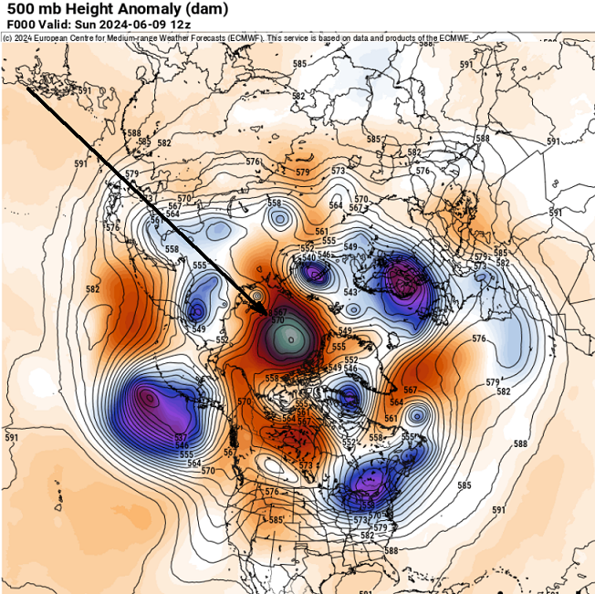
Did anyone else notice this sneaky oddity ? 576 nodal heights over the North Pole -
-
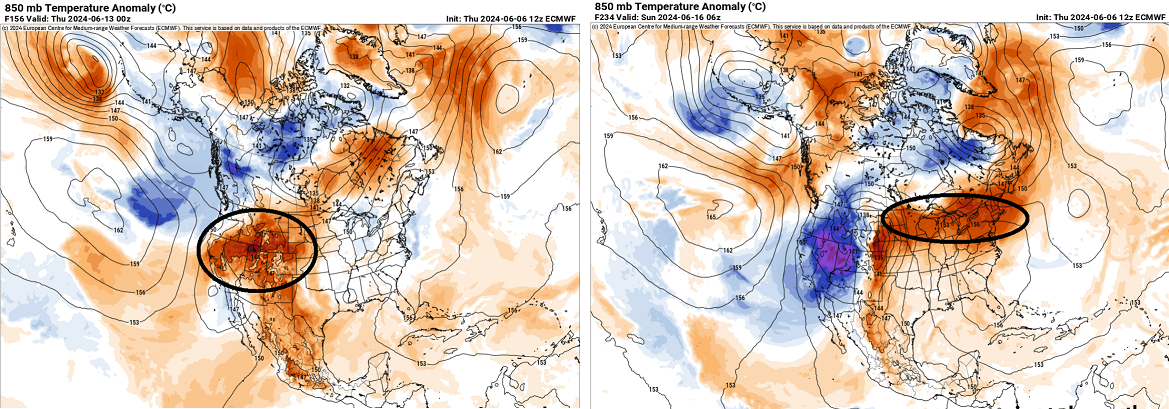
It's funny ( perhaps in a not so ha-ha way ...) how if anything, I've noted the 2-meter temperature renditions for all operational models in the D4+ range, are almost always NOT representing the actual 2-meter temperature. They seem to stop the extrapolations short of the real surface, stranding the high temperatures as much as 4-6 below what the synoptic metrics would arguably support. < D4 this is less obviously so, but they are always too cold at the surface in winter cold loading events, and too cold in the summer during heat loading for time periods beyond. Not sure why... The Euro has 23.5C over NYC D9 or around then, with WSW wind coming from Pheonix AZ, under a 850 mb Sonoran thermal shock ... 97 Okay. I mean that's plenty hot. LOL. But that's like a 810 mb tall BL mixing depth and probably a 104 if all that other juggernaut sets up like that. It does put up a 102 on D10 tho, which is the haha because the above vitals are still bangin away. Obviously, we're not talking about a prediction from this time range - we're just running over the parametric gunk.
-
Warmest implication as provided by the foreign operational models I've personally seen in several years ... The op GFS is blocky up over Greenland, driving a polar jet down through the middle Maritimes. This is an aspect that it wasn't engaging with prior to last nights runs. We'll see, but that's an outlier comparing to its ensemble mean, which does not engage in nearly as much (if any) +anomalies over the N NAO domain. The model is in fact an outlier to every model source technology there is, fwiw. This model seems to go out of its way to engineer heat suppression, I've noticed, as one of it's bias charms - it's not a good choice for ferreting out heat departures in the longer ranges because of that. That said ... it doesn't make it wrong every time. The ensemble means are impressive from all three sources; though they vary some with particulars, the principle sell by all three is for a class in +PNA --> -PNA instructive SW expulsion of kinetic air layer, into a highly coherent eastern positive anomaly. Pretty text book... doing so on the solstice is just an eerier bit of another impressive timing bonus.... This is all going back a week or more with broadly applicable techniques, and now ...the last three day's worth of runs with coherence. It's really more about being this clearly signaled, this far in advance.. We're still talking about beyond D7 or 8.
-
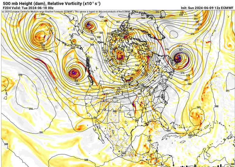
Hello Euro with heights closing in on 596 centered over the Del Marva. First time since we began ferreting out this pattern change have the Euro and GFS been agreeing in principle about magnitude in the E
-
The latter is probably the best way to go for now. Climate would infer heat false alarms in June modeling is probably more common than they are actually realized. We sometimes do get big heat numbers in May and June ( 1976 freak April). Obviously you know this... but the return on that doesn't match the frequency of model signal selling during this time of year. [enter reasons here ] our big numbers more apt to verify after the 4th of July Right now the the +PNA is scheduled to at least neutralize really this week. In fact, all the telecon sources are nose diving the index from an impressive +3 SD ... all the way to neutral by Wed? yeah, holy shit. But it stops descending around -.5 and then bounces around neutral-negative for a week. That's technically some kind of mode switch, but is it enough? The spatial layout(synoptic) of the ensemble means from all three, GGEM/EPS/GEFS, have +hgt anomalies N-NE of HA, with concomitant -hgt anomalies encroaching on the Pac NW and eventually western N/A. The natural telecon down stream is +hgt anomalies erupting over the eastern mid latitude continent. But this latter aspect ... for some reason the models are being coy with that. Some of them even attempting to not raise heights once in awhile which highly suspect. The operational versions of these have varied from shunted heat to more signficance with poor continuity. Yet again... after backing off, the 12z GFS comes right back with a textbook SW U.S. to NE conveyor torch ... This 200 hr outlook was originally supposed to be by this Friday, so we're also observing some can kicking too
-
may be able to salvage mid afternoon on... yesterday the fast moving convective/CAA clouds diminished at 6ish pm, and we had an 1.5 solid hours of warm sun. This 4 week window in the solar calendar can do that. Sat has a rapid motion with thinning already approaching the west side of ORH hils
-
We've had this kind of look at this sort of time range in the extended... it should be a D6 by now. seems like I've seen this at this range for 5 days now -
-
Yeah we've been talking about this for over a week now... I guess we need to see a tweet to be impressed with it? LOL It is interesting to me though, how we can cover a phenomenon until the dead horse wasn't just beaten but vaporized, ...then the tweet rebroadcasting kicks in like its this awesome thing. haha. Anyway, there is a pretty significant seesaw in the Pacific mid latitude circulation mode that's above normal confidence. Above normal because every ensemble system there is not only spatially represent the change, but this is also reflect in the numerical teleconnections. Negative height anomalies N-NE of Hawaii are replaced with positive heights through that region. That heralds mode change +PNA to -PNA. Now... those with a modicum awareness in this field might proffer that the PNA becomes less correlative as we get on with the warm season, and they'd be correct. However, if the shoe fits ... It's not a "0" correlation either. The data is overwhelming when its every source. The operational runs have been variable about what to do with it. Generally display above normal temperatures, but they haven't really pulled the trigger on a big dawg dome. The above symphony songs like its possible, but ...a more tepid result would also fit inside that scaffolding - an ending statement I am sure the KFS model will take to heart and resonate with fully.
-
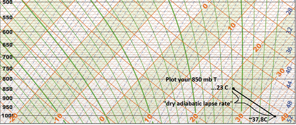
Here's a blank skew-t/l-p diagram (below 500 mb) to assist the sounding/sigma elevation to sfc relationship, provided the atmosphere is mixed to the sigma level. ( (37.8 X 2) - (2/10 X 37.8 ) ) + 32 --> (75.6 - 75.6/10 + 32) = 100.04 However, we are not at 1000 mb sigma as our surface altitude ( sigma is the elevation in pressure coordinates)... You can go ahead and add/assume a higher pressure than 1000 mb, which if you run the dry adiabat for estimating, you'll derive something more like 103 to 104. But here's the thing, the "2-meter" temperature also is typically a super-adiabatic layer on sunny summer days... so that adds a little there too. Art: When I use the T1 temp off the NAM FOUS grid, which is ~ 980 mb at LGA and BOS, I figure that's needs (usually ) lengthening that extrapolation by 20 or 25 mb, which adds 5 to 7C to the T1 temperature ...particularly in and around micro locales that are climate red spots. So 22C at T1, is really more like 28 or 29C over your drive way or walking across the street downtown or parking lots. Like today. 22 C and we're 84 (28.x C) west of Boston of interior eastern Mass.
-
Day drinkin?
-
temp blew up here. bolted to 86 when that cloud deck slipped off a couple hours ago.
-
we were playing disc golf most weekends all winter - it was actually preferably nicer than traipsing around fairways under hot sun... but, the ticks were being flicked off every every other outing. all winter long
-
wonder if this will be one of those summers where this is always on the extended charts
-
Operational runs are backing off the implications they carried yesterday. We'll have to see.
-
Yeah ... I distinctly recall, that was the version of the GFS that was particularly awful in handling boundary layer thermodynamics. Folks might remember that 37/30 during 3" of QPF Nor'easter earlier that March. That storm ended up 33/33 cat paws... but because the 37/30 looked so egregious... many thought ( including self ) that there was a chance that was setting us up for a blue monster. But instead it just kept raining at 33 ... 34. Very frustrating event for late winter enthusiasm. We did eventually get a blue bomb later that month but ...anyway... later in the Summer, that ridge with 606 DM non-hydrostats was putting out those 110s over eastern Mass, in the GFS runs, and as you say, we corrected the DPs up to reality, and that sucked the temps down. One thing about that ridge event/heat ...96/75 -like, there was no and/or only very weakly coherent SW heat mass release. I've always maintained that we might have been robbed our 'Pacific NW' notoriety but the fact that we had to home grow heat and not get the table set gave us towering heights with room to spare..
-
Nasty heat wave on that GFS run
-
Wasn't paying attention but it's 75/70 here with sun now coming through now.
-
Right ...and the end game is open ended ... From this range that far side of that is beyond the 'probability horizon' - it's just an expression I came up with to describe the temporal boundary, beyond which is equal probability for any given result is even. N/S ( no skill ) as it were. Depending on the pattern contention/degree of confidence - which can be derived statistically tho complex - determines that range. You can sort of intuitively see it though... In this case, every source that provides telecon spread, unilaterally neuter the PNA and now are tending to even reverse into a negative ( though modestly...) beginning in 6 days and then knowing model error in general, sort of sells the pattern evolution toward that look on the front side for low money.
-
Classic Sonoran/SW heat release phenomenon in the Euro
-
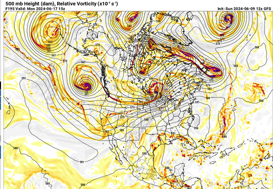
Heh... helluva signal materializing now in the operational compendium. They're all over 590 non-hydrostats spanning over the eastern mid latitude continent beyond D7. 588 dm canonical big dawg is broad and expansive and N of our latitude. Heights approaching 596 in anticyclonic axis over WV ... Wouldn't concern too much with details ( obviously ) at this range, if the gist of that scaffolding is correct, that's going mean the biggest heat wave we've seen up here in New England in some years - at least per my own recollection.
-
I don't know how anyone would be daring to assess anything less that hostile hot or inimical to winter ever again with the way CC's not only winning in that debate but flogging heads with its trophy. LOL
-
Could use rain here at this end of Route 2. We just spanned 5 consecutive days of near or over 80 days, with low side DPs, under and anomalously obstructed insolation. During solar max, that's a rather high evaporation rate. Ground water is still elevated no doubt - but just for surface purposes.