

Typhoon Tip
-
Posts
43,366 -
Joined
-
Last visited
Content Type
Profiles
Blogs
Forums
American Weather
Media Demo
Store
Gallery
Everything posted by Typhoon Tip
-
3 minute W oughta do it
-
someone's gotta ping 100
-
Not to be a dick but I have felt it worse. That late June 2021, the one that fried my kitchen refrigerator and blew out my window AC on the same afterfuckumnoon was right up there. It was 97/79 as I recall on the average/Davis' one of those afternoon in that 3 days stretch. But yeah, this is pretty awesome. 98/76 here and 96/75 on the MODIS ob at the Oxbow and there is less breeze than yesterday- so very little ventilation amid 110+ HI is a miserable picnic
-
heh looks like failed leaners to me so far
-
we're about on par with yesterday relative to hour but it just edges worse today. I'm wondering if the DPs are just 2 to 3 clicks warmer and that's the difference. might have to break down here and spin up the AC before end of work hours. something i don't like to do. fan isn't cutting it.
-
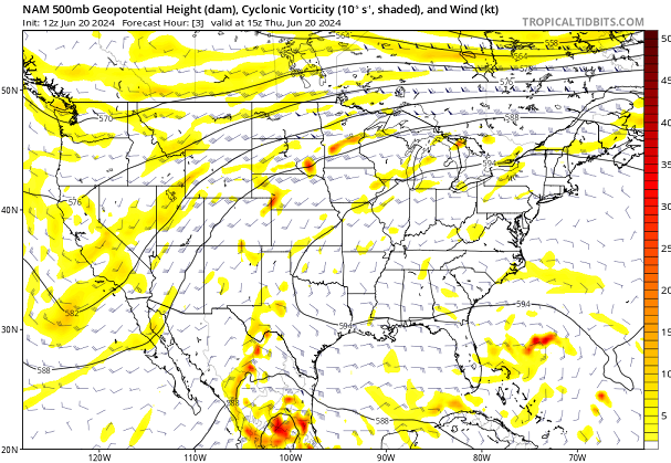
NAM keeps the boundary along Rt 2 ...sort of diffusing it a bit, too but the time spent with E wind at Logan has been shrinking, and is shrunk down to just 4-6 hr pulse and it's weak on this run before coming right back around S. But this is trended(ing) ...unknown if it's finished doing so. If not, there's a chance this frontal positioning was bs all along. I've never frankly liked the model position ( all of them ...) given that it looked like it was too far ahead of the height receding - we'll see.
-
Finally seeing some towers albeit small... thing is, the heat's so intense that things can go quickly. Like a small couple of pixels white cu is an anvil in two frames. Hunga Tonga–Hunga Haʻapai style
-
yeah, I can't tell in these light wind/high heat deals. the homes sites ( 5 of them ...) about 1/2 mi from my pad, two of the are 80+ and 3 are 75 to 77... Yet FIT is 73. I guess it is more miserable at our homes then these ASOS? I'm not sure I buy it that they are all bad sensors but who knows -
-
Do you think that DP is legit ?
-
Yesterday we already saw terrain towers by now.
-
it will .. but, they are moving along and the sky is cleaner over western MA, eastern NY so it's not likely to limit substantially enough to tell much of a difference.
-
yeah, I was just looking at that obsessive drilling of the front thing - why are the models doing that? It's not just the NAM... The global's had been arriving the boundary way ahead of any mid level support as well. Yet, looking at WPC's sfc analysis, there is a front aligned roughly the ST L seaway to DTX. It's both stationary and attempting to advect in segments - so albeit slow it is there. I think physically the boundary should limp and probably lose identity, until the deep layer mechanics improve but we'll see. I mean you look at this and the last thing that leaps to mind is a front even where it is - however closer inspection... if you look closely N of Lake Superior you see a subtle confluent structure to the isohypses. I think the models have been playing that featuring up a bit. There does seem to be a subtle tendency to back off as get closer... so we'll see
-
just saw that ... ha. It seems to be growing like fungus in a petri dish on vis loops. Heat's fragile. one errantly wrong timed cirrus plume is a hundo killer.
-
welp ...88 FIT and 90 here as of 10 am ... "10 after 10" is interesting. Dps at local garden sites on Wunder are routinly 74 to 77 ... FIT is 72 ... but MODIS has the Oxbow site about 2 mi from here at 68 ... It's hard to know. Just figure 72 and be done with it. I wonder if we turn the wind slightly W when we get to max and mix, if so.... we click Dps down a little and temps get the triple deed done. actually edit, OxBM3 is 73 dp
-
Yup... been following. Next ridge roll-out/flex may occur starting ~ the 28th of June +. May be a hot summer in the works here. Although every year seems to be some positive anomaly comparing to climate anyway lately. But I mean even relative to that. ( as a side thought ... it almost seems to me that we should also be comparing the model depictions, and verification (both) against the average departures. In other words, against d(climate) - possible the average SD during d(climate) being most important. Because it seems to get lost when everything is +.3 to +3 to +33 and every possible decimal in between. ) Anyway, there's a coherent R-wave signal for a wholesale hemispheric nadir around 120 W that is ending up as the residual/rest state in all ensemble systems, after these mid range attempts to change ultimately fail. This began to formulate, about 2 weeks ago, when we began posting/warning this heat wave was out there. So long as that footprint stays the same, I would be inclined to suspect all fronts and troughs kicked E across the continent have a higher chance of downward amplitude.
-
Notwithstanding that notoriety there but .. it's 3 F ahead of yesterday per hour at both FIT and here 12 miles away as the crow flies comparing to yesterday, and both FIT and locally were 97 for highs. Hmm
-
Making America great again …
-
I guess one more day of this then we head into wavy boundaries and thunder chances for a few days. Gotta say tho … theees an underpinning -PNA that looks to persist. It may not take too long before we set up another dome.
-
97 was the high here without the asshole of a city up wind ...just sayn' with 97+ and FIT/ASH/MHT I'm not sure the temperature nuns are necessary?
-
Yes... thunderstorm debris from Brian ( his chicken poop caused it )
-
97 ..wow Upper 90s/75 dp... HI > 110
-
96 woof
-
nah... until browning kicks in it's all just hyperbolic
-
and BDL ...
-
jumped to 90 here... Same at FIT We seem to have removed the delay factorization

