Typhoon Tip
-
Posts
43,366 -
Joined
-
Last visited
Content Type
Profiles
Blogs
Forums
American Weather
Media Demo
Store
Gallery
Everything posted by Typhoon Tip
-
yeah...smearing Beryl's road kill up along a quasi stationary boundary that's paralleling the flow for optimum repetition
-
The last several runs of the operational GFS have been above normal temperature. But that run in particular had like every day 89 with a handful of days at 105 … The mean was like 94 …93 something like that. That’s why I said in the aggregate. I’ve often thought an interesting metric would be to calculate the number of hours above 90 and the number hours over 70 … or find the curve and integrate the curve to find out which heat waves have the greatest “IHC”-or integrated heat content.
-
May be the hottest single model run I’ve ever seen for aggregate in that 18z kiln run
-
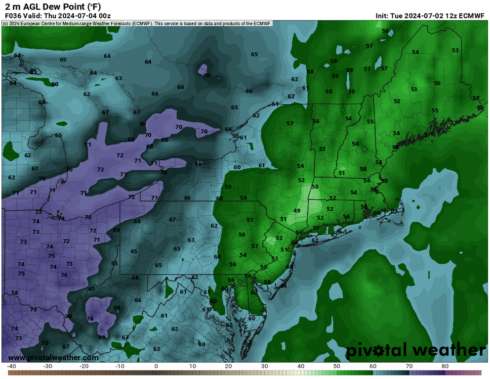
Some of the highest "modeled" DPs I recall seeing up in this region of the continent ... 75 to 80 from the interior Del Marva to ALB and BOS late tomorrow through early Tuesday. Temperatures are not even that remarkably high, yet 500 mb hydrostatic heights are almost 580 dm and in fact are down around PHL to NYC. That's about as dense with theta-e as it can really be -
-
I don't know about weeks n weeks... but there's a heat wave (seasonal ) signaled Mon-Wed this upcoming week. probably 90 to 95 in range
-
Yeah I'm not sure I'm biting on their surface layout just yet with that 500 mb look. That looks like front(s) stalling west of ALB and establishing the gradient ( weak ) SSW-NNE along the I-95 corridor Mon-Thur. Plus theta-e pooling
-
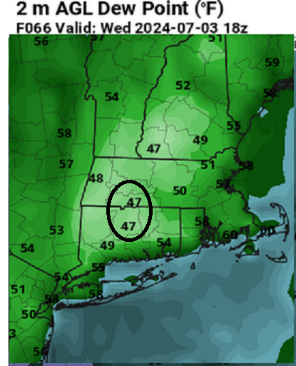
Yeah ..I'm willing to bet the DPs are in general not being handled quite right given that deep layer synoptic look there. Should be a little higher than the upper 60s. Euro really struggles to keep 70+ through the area in quasi Bahama circulation mode and the GFS seems to hold them down a little too. we'll see But that could all be the case without Beryl
-
Here's tomorrow PM "dewy" dps for the general audience
-
it's in your imagination... we're still in the solar max until August 2nd or so
-
whatever it is ...it's growing on decking surfaces around the shaded elementation. It may not be black mold exactly, but the stuff in my bathroom worries me. I keep looking for it and have a hot bleach water mixture on stand by - it seems to kill it almost immediately. I have an exit fan in the bathroom but it's old and needs to be replaced. I want to have a match blow out at the base of the door when the fan is on to make sure it's actually trading air and moving outside - not sure what's in there is easy to the task. I'm scheduled to have mini split conversion for heat/cooling on the 22nd of July. Psyched for that. .. But my buddy had those put in and says they do have moisture settings so dehumidifying option - it's my first venture into this tech so we'll see. Need to replace the exit fan either way - with that and the mini splits should be better for moisture controls. CC's a bitch.
-
It's been the leitmotif going back a few summers. Early heat or early heat threats then decaying into a semi-permanent trough or weakness along 90W ... We end up blocked off from continental heat while stuck in a soup pump. Haven't even been many Bahama Blue patterns for it, either. Just shit sultry DP miasma packing east of Apallachia. Strong argument for central air with techy moisture controls because I've been seeing more and more of these mid summer black mold blooms like on outside fixtures, and have found it in the corners of my bathroom - insidious nasty filth. ... I'm seeing signs that's trying to set up yet again
-
Should be in the mid 80s around here today folks. I noticed this often enough in the past ... it seems around 9 am the day's opinion becomes official. LOL.
-
Phoenix Experiences its Hottest June on Record
Typhoon Tip replied to donsutherland1's topic in Climate Change
Bold above: Part and parcel in the synergistic heat wave phenomenon, which differentiates from seasonal heat wave climatology. -
Interesting... because I've noted an early bias toward a quasi +AO rest state. I mean not huge, as that would imply. I'm not sure what thresholds are like prior to August 8th -10th ... which is the hemisphere's solar maximum. Post that, we're dimming rather fast up there. But prior to, it might be that +AOs have better retention capacity after early August, and that the +AO we've seen ( low amplitude ) is just not enough? hm
-
no... well that too, but I mean where the dp is driest
-
I feel like my point in sarcasm from the day before was made fairly well. Whenever you see risk assessments elevated east of ALB ... assume the scenario finds challenges to realization. There's that ... but in this case, I don't think the mid level lapse rates were helping matters. There was some organization into small linear segments but watching rad loops, it seemed the situation was a hybrid between that level or organization and just pulsing. Better lapse rates and perhaps a little more direction component to the total bulk shear... if we'd passed that over/through that 90/75 things would max better. Timing that 12z delivery over SE NY was useless too... We were vil choked across much of the area and doomed from the get go.
-
It's remarkable ...
-
Occasional Thoughts on Climate Change
Typhoon Tip replied to donsutherland1's topic in Climate Change
https://phys.org/news/2024-06-extreme-summer-climate-weather.html You know... just an extending comment on this article above. I was particularly intrigued by this statement/excerpt, "... Very large and strong heat domes, like the Northeast event—which reached higher into the atmosphere than any previous June event— " I was suspecting that this was true - relative to climate. We've seen excessive ridge heights tower to nearly 600 dam in the past, but not prior to July. Certainly ... not to 40 N. I hadn't bothered to find any sources that keep track of that metric, historically. This article indirectly makes the comparison/assertion. But what makes this interesting is that in the case of June 2024, this heat dome did not appear to receive an inject of elevated kinetic air layer from the west. I've referred to these type of phenomenon as "Sonoran heat release" - a geographical region that is perhaps more usefulness as an identifier. Probably just southwest heat release would be more precise. ... anyway, there is an all but codified hallmarked synoptic evolution that transpires, leading to a release event. +PNA traps air in the SW that is subjected to very high daily insolation. We can get a feel for this by looping WV imagery on satellite, during the +PNA mode, and noting the anticyclonic motion to the atmosphere over that region of the continent. Changes upstream in the Pacific than send a d(index) significant enough to alter the signature over the downstream continental mid latitudes, effectively bringing a heights falls toward the west coast --> dislodging the erstwhile trapped ultra hot air layers and sending them down stream. If/when that happens and the NAO is entering or is in a stasis +NAO ( rising escape latitudes of the westerlies, as well as tending to make the flow zonal through the Canadian Maritime ), the combination of these hemispheric scaled changes teleconnects to geopotential ridge eruption over the eastern mid latitude continent. We saw this series leading the June 2024 heat wave, but interestingly ... there wasn't a very highly charged air mass available from the SW in this case. Idiosyncratically, there was an early quasi monsoonal response taking place during the 'ejection phase', and this interfered with daily clouds and convection over the source region in keeping the 850 mb ~ lower. It's really the difference between the more common 97 type high temperature results in June 2024, versus "hot Saturday" in 1975, or the July 2011. This historically hot ridge ( or "dome" ), really left about 5 to 7 pesos on the field... Notwithstanding, the attribution aspects with CC were never really tested (imho) with the June 2024 event. A perhaps limited "syntergistic heat wave" is what really took place from the TV to NE regions. Simplest conclusion, it could have been hotter! Not only that, there is an identifiable series in the pathway to making that happen that appeared to be missing. -
Occasional Thoughts on Climate Change
Typhoon Tip replied to donsutherland1's topic in Climate Change
Now in addition to counties in PA ... the conspiracy has apparently reached the ECMWF CO's modeling operations branch ... .. because look what they've done. They've gone and diabolically seeded the model to hide any and all negative anomalies that would make this outlook even menial to climatology -
Wow... I don't think I've ever seen a "B" hurricane this intense. I'm sure it's happened before ( right? ) certainly not that often -
-
Agreed -
-
Nope... over. that's the nature of the premature convectulation - now, watch CB bums fade into the eastern horizon the rest of the way, after the sun comes out in another 2 hours and it's 5 pm
-
getting light butt bang rains along rt 2
-
Operational GFS is at or > 570 hydrostats from D3 to D12 on 06z ... Almost that long on the 00z. Both are showing a low more WAR than other guidance, too. May just be a peregrination ... the ensembles have a -PNA in the foreground but tend to neutral way out there - but clearly ... the coherency and correlative usefulness is entering the seasonal low from the looks of things. Enjoy your tornados today!
-
This warm sector means bidness yo 77/74 here at dawn. Even FIT is 70 DP at dawn with a 77 over top. ORH 73/72 Arubian air mass.