

Typhoon Tip
-
Posts
43,360 -
Joined
-
Last visited
Content Type
Profiles
Blogs
Forums
American Weather
Media Demo
Store
Gallery
Everything posted by Typhoon Tip
-
December 2024 - Best look to an early December pattern in many a year!
Typhoon Tip replied to FXWX's topic in New England
early feb 2023 -
it's what that could be, yup ... in fact, if you cinema the chart you can track that/those as they get booted east through the continent - i was just pointing this out in previous post. the difference there is that if wave is not trackable and the height impression is more statically positioned, it's more likely to be an artifact of the ensemble noise.
-
no, i meant an event - but the point is ...the ceiling is higher than normal. that's still not forecasting anything specific though. the pattern aspect is greater than normal confidence for this time range, do to a collection of sources ... i call this "teleconnector convergence" ... that favors the genesis of events even more. just as a primer, whenever you see a large scale change in the pattern basis, like that which is clearly being demoed now by all three ens systems ( eps/gefs/geps) to take place between the 30th and some unknown time beyond ( in a similar time span) , during such period that is when events are more favored to materialize. within that facet, there are some markers in the eps ensemble mean at the time, and that's when it gets more interesting. any one of those wave spaces that times through the continent, while that canvas is going on, has a +d(amplitude) implied. that's what the eps had yesterday, which i annotated ... it had a s/w injected through the west, and it was getting a huge positive feedback from the aforementioned background pattern change - a change that correlates to events. i suspect you want a clear and concise declaration for a big event ? it should be okay to address the potential of one materializing without being held accountable to one. I'd probably would have started a thread/conferred doing so if i thought i had that worked out. in fairness, i'm interesting in the 31st ...and how it may set the table for the 2nd/3rd, but the vision is way too primitive for now. anyway, that's what the 'massive' adjective was about. it is just because the relative scale and degree of the background pattern change, being that it is highly positively correlated, that means the ceiling is higher than normal.
-
no apology necessary ha. just that folks have sort of a 'constructive memory' - if anything, it's good to point all this out, to avoid that 'mechanical engineering' lol
-
it's amusing ... but also - i'm not on the big storm train? not yet, anyway. i'm on the favorable pattern train, luxury accommodations, too, but just for the pattern. as far as specific events the may come about, the nearest one that may emerge is ~ 31st, which as of the time of previous words was 10 days away; thus, to rule out the 31st is a bit braver than i. considering the panoply of different tech sources + personal experience + personal techniques) ..divided by 3, it really averages out to a period of interest that begins around 31st, but really also has a blurred ending... i've been saying 5th or 6th, but really the pattern carries on right to the temporal horizon of the ens mean, both in the spatial layout as well as the telecon numerical derivatives. the latter, btw, signals the 31st still as of this morning reviewing those... the one for the 2nd/3rd is actually slightly less supported, and there's not really a signal at out for the 6th there ... however, the spatial/ synoptic and super synoptic ( this latter contains aspects such as trends and even 'intangibles' for lack of better word) suggests a correction tendency toward emergence - that has to be speculative for now, unfortunately.
-
December 2024 - Best look to an early December pattern in many a year!
Typhoon Tip replied to FXWX's topic in New England
prediction ... we'll get a significant system on the charts for the 1/2nd ... then, the 5th appears, and starts to take over for a few days. the 2nd perhaps almost disappears in lieu of 5th...then, on dec 30 at 12z the 2nd comes roaring back and the 5th is still there but it just looks like something's oddly pulling at it. then the 18z is the same-ish... but the 00z makes a sudden all out bomb out of the 2nd and the 5th is shredded... or, reverse that order - i mean, that's the song and dance, not what Tiger' just snarked - -
yeah i've been noticing that too but i'm interested in if that stays that way. pointing out the obvious, the eps and geps go out that far and don't present that much recession of the height medium. i've also seen that correct back upstairs as it nears. so as is ... that's not something i've seen really in some 9 or 10 years - perhaps 2015 is the last time. sufficed it is to say, that would slow the flow down and allow things to amplify up under as oppose to a race between stretching and deepening rates... edit: upon closer eval ...yeah that flow over the gulf and across florida has higher compression potential than we've seen in recent seasons. the old "miami rule" works, having the 582 south, with a big enough isohypsotic gap that the winds are not already buzzing a s/w eating 50+ kts before anything has a chance hit the se coast. again, i've seen that medium down there correct back upwards from this range in the past. we'll see.
-
December 2024 - Best look to an early December pattern in many a year!
Typhoon Tip replied to FXWX's topic in New England
yeah ...my 'period of interesting' is the 31sth thru around the 5th or 6th ... the whole interval is heading into the basement. yesterday i liked the 2-6th - already posted but I'm shortening it a little out of deference for the nao uncertainties. that cinema above was more to point out that the background/super synoptic ( non-linearity ) of the pattern is so conducive that even the ensemble mean is amplifying the first critter that dares to pass through that domain. that structure is nuts for this range. but also, even if it is that first wave ... i'm not about to begin any debates on the temperature at this range anyway. the -nao may be handled poorly at this range ( positioning that far S is suspect a little frankly ...). point is there's room for correction, perhaps the obvious statement -
December 2024 - Best look to an early December pattern in many a year!
Typhoon Tip replied to FXWX's topic in New England
the 12z eps mean was really just fantastic it even targets a critically timed wave space injected through the western ridge, then ... into continental arena of rapid d(mode) ... at 324 hours. it's actually got continuity off the previous run cycle, just more coherence on this rendition. the gefs and the geps have at least the overall signal too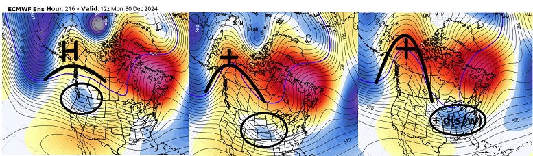
-
this is one of the most extraordinary constructs you'll ever see out of an ensemble mean for this range and current modeling technology/capability ...
-
December 2024 - Best look to an early December pattern in many a year!
Typhoon Tip replied to FXWX's topic in New England
not sure where to put this as it may actually segue around the 30/31st ... i lean jan 2nd but i'm pretty sure if i put this in that january thread it will be get missed. from a purely telecon inference, there is a huge signal for the first week of january for actual winter storm. i get it that the epo is diving and so forth as others have also noted ... but i'm not talking about just cold or a cold pattern signal. i'm saying that there's a potential for something massive over the eastern mid latitude continent between the 31st and ~ jan 5 or 6. so obviously the coherency isn't very good so there's not much to comment or speculate after that. it could be a big ordeal, or perhaps a series that cumulatively exhaust potential, but it's been a long while since a teleconnector convergence projection. i can see several different correlating modalities, converging on jan 2 - if having to choose -
that would be the one. I had lived in Rockport, Ma the previous year, a time when I gathered my first experiences witnessing the thunderous power of the north Atlantic. There was really only one coastal storm during that winter I was there, but that was enough to get me really hooked on the phenomenon of storm wind, combining lower barometric pressure, turning the sea into a monster. Creepy cold abyssal walls of camouflage green that rise up to a knife edge just before folding over with such force that when standing upon the beach, feeling quite insignificant before that specter, you could swear you felt the tumult seismically under foot. I'd never seen such sights before ... having grown through adolescence/early childhood in southern lower Michigan. I was all about crispy tcu's and tornadoes. I witnessed an EF3 tornado, on Tuesday, May 13, 4:30 pm, Kalamazoo. A dimmer switch stole the daylight over the preceded 20 minutes. Then, the WWII era air-raid horn started blaring. The sitter yelled for me to come into the basement - I looked at her with the expression of a sociopath, turned and ran instead toward my favorite thunder-cloud clearing. Lol. There I saw the cone, perfectly smooth subtended about half way to the ground beneath from my rough 1.5 mi vantage. It looked like swarms of bees were rising and falling in pulsating masses underneath - and it's quite true about that sound... I'd only add, it's not really just like an engine test adjacent to an aeronautical proving ground, but it had this like shrill, as though the wind itself was shrieking out in pain. It's fantastically arresting - nothing else matters when you are child bearing witness to something like that. And it was the best seats in the house! I was in that wind void region, ahead of the RFD, and having the inflow jet a few hundred feat over the tree tops, providing a relative calm to see how effortlessly the blithe beast discards whatever it is that fate happened to put in its path. Mainly what I saw was single story urbania being ripped into the vortex. 7 people lost their lives that day. I sometimes reflect upon that moment with that visage of carrying on in that not-so distance, that I probably was witnessing actual death take place. Oh, and for that little act of sitter defiance I earned myself a week of grounding - a ruling that would be later commuted. Some punishments are just to futile I suppose .. 2 years before that ... the Cleveland Super Bomb. I was not here for February 5-7, 1978. But the January 26-28, 1978 event that took place 2 weeks prior, I can honestly say I have never experienced anything of winter rage that nearly compares to that in the decades since living here in New England. But ... in defense of New England, the 'maintenance winter storms' of winter season, are vastly more common and produce greater entertainment value in aggregate - by a considerable margin. This is in no means attempting to strike up a competition between the two... it's kind of like trying to compare Mike Tyson in his prime with a Rumble In The Jungle version of Ali. Beside, .. from the accounts of Harvey Leonard ( whom I'd later privilege to intern with) and others that grew up in this region, Feb 1978 was probably more like a twin seasonal thing... probably should consider 1978 a GOAT year and just call it a day. So, I was not completely miss-understood regarding winter storms when I arrive out here to the eastern tip of Cape Ann in the mid 1980s. But the whole ocean aspect was something I really wanted to get back to after my family relo-ed again to Acton during 1987. Having friends still in town up there, it was an easy arrangement to dork may way back for the big storm. As it were, we really didn't suffer a lot up there. Some small boulders and a large yield of seaweeds hurled onto the streets of Front Beach at high tide. And of course ... lots of heavy spray and mist pelting along sea facing shops and edifices that line the shore fronts - like what you see on t.v. I'm not sure how Marblehead and Hull and LI Sound and the Jersey shore did... My memory has an impression that Jan 1987 was the highest storm tide event ( though ..) until the December 1992 event.
-
that looks like an odd suggestion of an El Niño stj undercutting a whopper La Niña EPO
-
Ok but why? lol
-
12/20-21 Clipper/Coastal Nowcast and Obs
Typhoon Tip replied to Boston Bulldog's topic in New England
The nam was too aggressive this morning … But it did have the right idea yesterday with a couple of run cycles being northwest of other guidance -
yeah ... females are awesome ? what does that mean
-
we've actually been onto that and other aspects surrounding the increasingly enso uncoupled periods of vaguely correlative hemisphere's, going back many years in this subforum actually. agreed -
-
that's one helluva a cold signal in the super synoptic projection - like to see the mjo swing around... but i'm willing to bet it unfurls in the rmm guide given time. that latter aspect is interesting ... as much as the phase 5 [apparently so ] neg interfered and kept this +pna lower frequency, that may be an indicator that the overall timing of the forcing is in sync on the left side/Americas
-
yeah, again .. i don't disagree. in fact, most nam variations are risky usage outside of convective initialization - hidden secret. this is a meso-beta scaled consideration below. just in this one handling arena, where is near coastal thermal compression/intense hydrostatic gradient ...etc. when q-g forcing (-omega) runs out over top... the problem with an overall gradient rich flow regime ( i.e. tending to stretch the x-coordinate ) the globals will tend to outpace the cyclogen response in the lower troposphere. it's obviously a resolution issue below the boundary pause, where the nam is likely better resolved, it has a lengthier lifted condensation and more proficient latent heat release ...adding to uvm. better/quicker/deeper uvm response leads to the nam just being faster with cyclogen ... even just marginally so that tends to scrunch the realization closer to the coast when that happens. i would also argue it is why the nam has a nw bias at 60-84 hours... it's could be at other times over assessing that instability.
-
yeah i here ya. you know ... sorta supposition but, i've been yammering about this subtle progressive bias in the gfs for years. it's really almost down to the nuanced level, but it's there .. always tending to pull or stretch at the x-coordinate component of the wave function. i think it's ultimately related to the same reason that compared to other guidance, by d10 it's typically cumulatively colder heights on the polar side of the westerlies ... even if only by 2 or 3 dm, but i've seen it be as much as 10dm in trough nodes. that overall integrates just enough annoying more gradient to cause the balanced the g-winds in the westerlies the girder to the ferrel trade latitudes to have necessarily more speed...etc. i remember snarking many pages ago ... if there's ever a situation that requires a west correction the gfs would likely be the last model ever admit that. heh. i'm not sure it is 'the last' in this case, but seems to have waited until pretty late the game here. interesting
-
12/20-21 Clipper/Coastal Nowcast and Obs
Typhoon Tip replied to Boston Bulldog's topic in New England
looks like there's an amorphous cf as anticipated - it may become more defined ...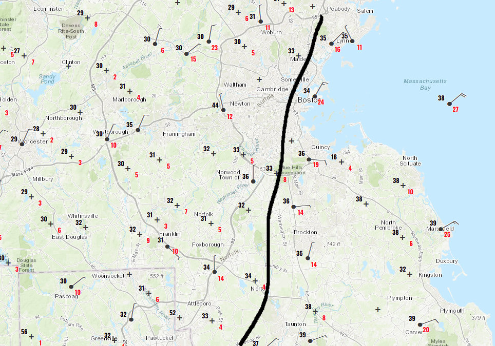
-
I tend to agree ... i outlined a few meteorological aspects a while ago that goes into the why-for the (bold ^ ) tact is advisable. altho, i do suggest the NAM physics are very good for these low level hydrostatic gradient deals - just to add. the gradient/steep elevating frontal slope enhances rising motion along the up-glide that's triggered under what looks like might be under done q-g forcing in that area. we'll see.. but whether this means more low sfc pressure resulting, farther nw of previous guidance clusters or not, there's classical mechanics of qpf blossoming between central jersey to se nh. also noticing a 300 mb entrance fan to assist with that over central ne
-
12/20-21 Clipper/Coastal Nowcast and Obs
Typhoon Tip replied to Boston Bulldog's topic in New England
this particular statement is only symbolic/jest but man ... the sky has that look! seems like it's been many years since that patina gray density dimmed the daylight so ominously over an actual gelid air mass such as this. and on this side of christmas - -
oh, there's a obs thread ... i guess we should move all this over there? whatever i guess. Will, does that rad up date in this frame or do you have to post that -
-
yeah thx Will that confirms my idea there - as far as i can tell... there's obviously a jet streak running out s of that central axis of rotation, again ... roughly sw pa, but there is sooo much potential along that axis between cape may and the waters s of cape code that i'm curious about that eddy mechanic traversing over that region. the left entrance of the jet max (s) may be more activating of cyclogen response rather than being completely guided by the right side/entrance region like the globals


