Typhoon Tip
-
Posts
43,360 -
Joined
-
Last visited
Content Type
Profiles
Blogs
Forums
American Weather
Media Demo
Store
Gallery
Everything posted by Typhoon Tip
-
Eye candy art time

-
Run is better behaved but obviously at this range no hopes should be set
-
these are the ones with mass field modality support 1/2 8/9/10 (negotiable at this range )
-
slow evolving epicosity on the telecon inflection event out there at 8/9/10 tho
-
luckily for me that run is laughably badly handling the local hemisphere and is unlikely to bear reality then
-
that’s an ugly handling around the 7/8/9/10 actually.
-
no it's not always one or the other. just in deference to the outlook "if" it were to succeed that's also for the whole month. the current climate back ground connotes less probability for those cool sides and/or a diametric month like your describing there. that looks like a bombastic lay. they're right that being on the polar side of the boundary would be a whole different world, but i don't believe acceptance of the current climate leans one in favor of that
-
in fact ...we've well established that february is capable of shock and awe warm departures, particularly over the last decade of them ... with multiple different years in the span hosting febs with 70s even an 80 on a couple occasions... ( nothing wrong with 30+ anomaly high ). i would consider that outlook fair warning -
-
i don't believe the current climate footprint should reasonably imagine a verifying cfs outlook working in favor of winter enthusiasts.
-
yeah ..there may be a few interpretations. all i know is we got 13" with some sleet on top in acton ma. by late afternoon the next day, we were driving around town like normal.
-
1993 was a triple stream phase. in fact, the geometric wave space was arguably in phase from the latitude of the arctic circle of the nw territories, to the nadir of the trough as it was spawning the zygote circulation over the western gom. i like to metaphorically compare it to a 'rogue wave' event in the atmosphere. that's that thing that occurs in the open ocean, when surrounding waves suddenly decrease in space significance, while this one towering giant lurches up that is sometimes 3 or even 4 times the height of the previous mean trough to crest wave heights of the surrounding sea surface. this is thought to be what took down ships around bermuda, as the g-string current would cause huge wave crests when northeast gales are in that region - favoring the genesis of rogue waves. edmond fitzgerald etc anyway, the atmosphere's a fluid medium that obeys fluid mechanics ... which is wave physical. maybe it's not so much a metaphor
-
okay, following up ... this was never high confidence for snow, guys - there's no 'sinking ship' really. reading is a problem in here. it was described as very marginal, with snow perhaps 'collapsing toward the coast in the last 1/2 to 1/3 of it'. and, at the time .. was largely based on colder trends from various guidance sources that occurred yesterday. i did say the bold (abv) to Scott. well ... that's summarily what happened, unfortunately for snow enthusiasts. it trended back warmer. oh well... i mean, these were/are minor trends oscillating on either side of marginal, and this is what you get. there's still a non-zero chance this could amplify and end up more se again. fwiw, the ggem is persisting with potent look that offers a decent nor'easter. it's not a snow vs rain discussion point, but having a sub 990 mb low approaching from the s, and ending up in the boston harbor as a 982 mb is noteworthy for those that are interested in the meteorology of it. granted ( haha ) not the most popular model in the tool box, no.
-
1993 was too far inland imho - .. i'm butting in here. not sure what we're talking about. haha ... but if we're discussing impact relativity. 1993 was really more of burst of heavy snow that was comparatively rapidly recoverable along the 95 corridor/coastal plain east of the apps cordillera. the snow did not collocate so well with population density/geography, as well as that 1899 appears to have accomplished. part of my bringing this up is because 1993 always pissed me off. that was 10 days of d-drip bliss only to have the best heroin land along the roof top of the Appalachian chain? f* that i was down here in acton ma, about 30 mi w of boston as the crow flies, and we got 13" crusted over with 1/2" of sleet. i realize the specter of the storm and it's particular vitals, et al, were quite possible goat ... but it didn't seem from phl to bos like that was really our storm.
-
isn't hfd one of those climo sites/thermometers that y'all are trying to indict as needing calibration ? i'm noticing that altho december is ( so far ) below normal at the 4 sne majors, it's not hugely convincing. .ranging from -1 to -2 or so. so yeah, it's fair. perhaps not a bad achievement in this day and age when getting a month to neutral seems to be a challenge but hfd is just -0.5 so precarious. i'm wondering if that's suspect? i was also wondering if might get warm enough during these next couple of days to pull that -0.5 to neutral - i guess now that it is the end of the month, there's a lot of weight there and it'd take a lot to move the needle so prolly not.
-
of course ...with a look like that it 'seems' to finally be more correct with improving performance, huh lol
-
yeah … the eye candy has its entertainment value and it’s fun … i don’t think that’s our system heading towards the 11th tho …i think we need to watch this period here
-
we have a difference of opinion on that. as is... the hills of n ct up to the monads and across se nh is a colder signal - marginally so.. but I'm also not taking this model literally I'm correcting based on plenty of precedence and pure experience with that sort of look. the chartage painting blue qpf is more of warning really. heh. we'll see. it won't take any warming or that interpretation doesn't fly - no issue with that...
-
agreed on the trailing vorticity feed tho - mentioned that above too. forcing an inverted trough and squalling
-
yeeeah wouldn't worry about gfs 2-ms or even the 950 mb to sfc interval at this range, not considering that wholesale synoptic evolution. that low is moving along climo path with ( at least in this guidance ) a sufficiently cool 1300' thickness - also probably an underestimated hygroscopic cooling factor, laid in from the 30th system backside air mass. wind backs nne in the interior in that and any marginal sfc air will turn blue with lift over top, forced by negative tilt causing bend back frontogenic .. etc these aren't certainties... no. we're just talking my interpretation of those synoptics. also, i'd note that marginal 'blue snow' scenarios tend to look that way in the low levels at this modeling time range. the isothermal sounding isn't seen until it almost happening.
-
it may be more nyd afternoon into the evening hours. also, 33 .. 34 type snow event so elevations probably helping. looks like you'd do well there, from about where you are through the worcester hills/monadnocks into s nh. se of that axis is probably cat paws over to big aggregates before ending. but along the axis described, that could be burst lasting 5 or 6 hours at moderate rates. it's just the 18z, but since in principle it's decent enough continuity from the 12z it's a likeable trend for y'all winter enthusiasts.
-
interesting uppers there... we're still inserting wind max for some time after main cyclogen and pass off and it's forcing an inverted trough and squally snows to lag back for a considerable length of time.
-
18z GFS with a higher side moderate event from hfd to ash out of this potential event ... clear generation of CCB/mechanics there spanning 6 to 9 hours, possible even ending with cob webs off the eaves if right
-
ha hahahaha ... 'cosmic tip'
-
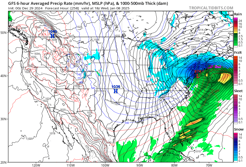
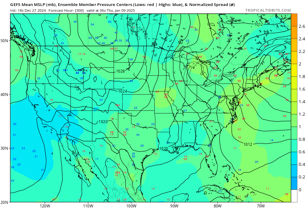
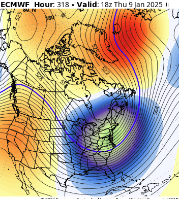
the 7th ... heh .. may be just a juggling and logistics thing in the runs, not sure, .. .but the best fit for timing the telecon modalities out there is the 8/9/10th of January. then this arrives in the 12z eps mean? .... yeah, i think y'all might want to wait a day. anyway, this is about as deep as there will ever be a signal at 300+ hours from an ens system. i was actually going give some time to this in that thread i started this morning but figured it'd be too much. this is like real wild territory there
-
i thought he was talking about the 1/2nd ? either way, the op was on the western edge of the envelope with the 1/2nd. doesn't matter much ...the mean was still only snowing ( maybe ) during the ending 1/3rd or so .. but like you were saying, there's colder variants arriving from other guidance. boy, 126 hours ... seems the model all-over-the-place-ness is worse this season. i think it's the low frequency waves in a high speed flow issue